

EastonSN+
-
Posts
7,917 -
Joined
-
Last visited
Content Type
Profiles
Blogs
Forums
American Weather
Media Demo
Store
Gallery
Posts posted by EastonSN+
-
-
-
2 minutes ago, RU848789 said:
Meh, still the least snowy model and no improvement vs. 12Z. Also, with modest rates and temps above 32F, this means difficulty accumulating during daylight (sun angle starting to play a bigger role now) and even after dark if temps are 33-34F, as per the model.

Still if it's the least snowy model that's not bad. If it comes in heavy enough it will accumulate the city could get one to three.
-
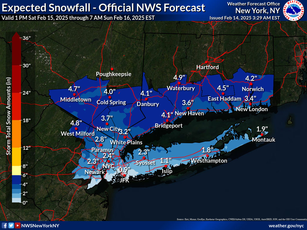
Euro snow map pasted it in New England forum. Looks really good. Central Park 2 inches and 2 inch line kind of goes through Long Island.
-
 1
1
-
-
-
48 minutes ago, wishcast_hater said:
Chaos to Clarity: Snowstorm Caboose Could be the Big One!
Snowstorm Caboose is a new one.
Phase 8 induced snowstorm Caboose.
-
1
-
-
The Delmarva has been a magnet all season long except for the one storm that targeted Florida with the heaviest snow (never thought I'd ever say that).
-
2
-
-
7 minutes ago, LibertyBell said:
There are winters where a storm like this would inevitably come north.....
Difference is this is not a slow monster pushing against confluence. In this case there is a kicker storm pushing the flow therefore it doesn't have a chance to push North. So a little bit different than situations like 2003 and 96.
-
1
-
-
Canadian took a step back.
-
1 minute ago, LibertyBell said:
I remember there was some discussion about this but it was awhile back, maybe even a year or two ago. I would suggest looking for keywords IO and IOD and Maritime Continent. The funny thing is that there are people reading this thread who participated in that discussion but they haven't responded.
This is exactly why I don't understand it's like the topic is avoided for whatever reason.
-
1
-
-
Amazing hit on the GFS for the Delmarva. What a winter for them. Let's see if it holds.
-
1
-
-
Actually liking this weekend for a light to moderate thump more than the 20th (closer and no suppression risk).
-
2 hours ago, EastonSN+ said:
LOL I raised this topic a dozen times in the subform looking for anybody to opine. You are the only one to acknowledge that it was ever spoken like it was some kind of voodoo, or the answer is too dangerous for us to know.
I keep saying the Indian Ocean is rising in temperatures so we should see an increase in phases 1 and 2 which in the heart of Winter are very cold phases. This is likely why January was so frigid because it was a high amplitude phase 1 and phase 2. That's Indian ocean temperatures.
That being said we thought the Indonesian high water temps would lead to a semi-permanent 456 phases however that has not been the case at all this winter.
@LibertyBell lol still waiting.
-
1
-
-
The 6z Euro snowfall map has been posted in New England forum in case anyone's interested. Has one inch in Central Park. Eastern Long Island on a North shore gets 2 inches. CT shoreline is three to five. Westchester county approximate two to four.
-
2
-
-
4 minutes ago, Typhoon Tip said:
Heights over western N/A are the challenge. This situation leading and during the 20th needs that component to improve, otherwise this will be another modeling challenge over the week with both spatial-temporal aspect, and just spacial synoptic interference issues.
It's a bit frustrating because from what I am seeing, the basal hemisphere is a little less compressed ( less is definitely better! ). You can see in the 00z 500 mb height cinema of all three, Euro/CMC/GFS, how the SPV fragment really tries to tuck into the S/stream, but because the flow geometry lacks that meridian restoring ( better ridge west --> constructive depth feedback in the east), the situation ends up stretched looking with the triggered cyclone escaping ENE in the CMC/GFS. The only real difference between the Euro and these misses is the Euro actually gets the thread through the needle's eye on 00z stab.
But again ... the flow overall is -d(gradient), and so if a ridge were to materialize over the west, that whole downstream situation would be slower/more proficiency compared to these bottle rocket smear troughs of the last month
Good analysis from Tip.
-
3
-
-
2 minutes ago, LibertyBell said:
Don't forget the warming Indian Ocean. I've seen it mentioned here and there (usually shortened to IO).
LOL I raised this topic a dozen times in the subform looking for anybody to opine. You are the only one to acknowledge that it was ever spoken like it was some kind of voodoo, or the answer is too dangerous for us to know.
I keep saying the Indian Ocean is rising in temperatures so we should see an increase in phases 1 and 2 which in the heart of Winter are very cold phases. This is likely why January was so frigid because it was a high amplitude phase 1 and phase 2. That's Indian ocean temperatures.
That being said we thought the Indonesian high water temps would lead to a semi-permanent 456 phases however that has not been the case at all this winter.
-
2
-
-
3 minutes ago, LibertyBell said:
It's a reflection of a proximal location on the north shore of Long Island that does really well in snowfall too. Mt Sinai and New Haven are both local hot spots for snowfall. They fit together like two pieces of a puzzle, did you notice how the northernmost part of the central CT shoreline matches the northernmost part of the central part of the north shore of Long Island? They were part of the same landmass before the last ice age.
I actually envy Long Island during the big coastals as the northerly wind in northeasterly wind cause snowfall to be a little more intense due to the sound.
-
1
-
-
6 hours ago, brooklynwx99 said:
EPS is very amplified. what a look
btw, that isn’t a SE ridge linking with the -NAO… those are height rises downstream from the amping vort

To any/all in the subforum. Don't want to keep breaching this topic, however, just need any explanation from anyone on what the differences are between this depiction where the SE ridge is NOT linking to the NAO compared to the instances BlueWave pointed out where it is.
What do I look out for to tell the difference?
Maybe Bluewave and Brooklyn agree on an independent 3rd party meteorologist to provide an opinion. Such opinion would be binding in the absence of manifest error.
-
1
-
-
1 hour ago, snowman19 said:
Still no change at all IMO. Next week is either a hit or suppressed/OTS
Completely agree when you run the animation on the op runs you see the confluence rotating down from the Northeast right as a storm approaches. Have to hope that's a bit weaker in the storm a bit more ampt.
-
2
-
-
4 hours ago, LibertyBell said:
It occurred to me that you moved to the jackpot area of the March 1888 Blizzard, Chris,
Just a couple years too late LOL. I believe that was a good spot for 1978 as well and of course Nemo. Three of the best storms in history for that area. They did pretty good in that bust of a storm in 2015 was over a foot there.
-
 1
1
-
-
18 minutes ago, wdrag said:
NO new thread for a wintry event 2/19-22 til late Thursday - 2/13 at the earliest or until ensembles come together again. Too chancy on a miss
I am usually positive thinking however not feeling good on 2/19 to 2/22. The confluence is strong.
-
2
-
-
1 hour ago, LibertyBell said:
Maybe there is a difference with an east facing beach vs a south facing beach in SWFE (a southwest flow is land based when the ocean is to your east, but comes off the ocean when the ocean is to your south.)
Barrier island so water east south and west.
-
1
-
-
1 hour ago, LibertyBell said:
Yes, some of these storms from the 80s sound very familiar. note-- the amounts were slightly higher back then (colder)?
WINTER OF 1984-85
Feb. 5, 1985 - The biggest snow of the winter began this evening and continued through next morning, accumulating 5.7". 3.3" of the snow fell tonight. This came three days after a snowfall of 4.3". After this snow just 0.2" fell for the rest of the winter.
WINTER OF 1985-86
Feb. 11, 1986 - The second 4.5" snowfall in the past four days occurred today and occurred between daybreak and noontime. These two small snowstorms accounted for most of the winter's thirteen inches of snow (half of the typical amount).
Thanks for these. Always hard to tell if would be that different today.
-
1
-
-
9 minutes ago, LibertyBell said:
The gradient is different with each storm.
For SWFE it's north of here
For suppressed systems it's south of here
This area does not benefit from gradient patterns because these kinds of tracks don't give significant snowfalls in this area.
Add to that for coastal areas being near the ocean makes it even worse for SWFE
I think there's two points being discussed. The storm track is the issue where it's cold and dry warm and wet 1980s style.
There is another point about it being too warm suddenly which I think is where the debate is lying where some are saying we're losing out on gradient storms because it's getting warmer but yet people are seeing snowfall on the beaches of the Gulf of Mexico. I am not saying this myself but some may be saying if we are suddenly too warm on a gradient why isn't New Orleans or Washington DC too warm for a gradient.
I think as Blue Wave mentioned we have a current fast flow which favors weak waves to the South and amped up waves to the lakes which would explain what's going on the best. This will change at some point hopefully soon and we'll get storms like we used to but who knows how long we have to wait.
-
1
-
-
15 minutes ago, LibertyBell said:
inland regions are less susceptible to gradient patterns aren't they?
That's not the case Ocean City Maryland got destroyed this year. Literally pictures of snow accumulation on the beach.

Discussion for a probable 2 or 3 winter storms/events between Tue Feb 11 - Sat Feb 15. OBS threads for each will be added as needed.
in New York City Metro
Posted
Borrowed from the New England forum