

EastonSN+
-
Posts
9,109 -
Joined
-
Last visited
Content Type
Profiles
Blogs
Forums
American Weather
Media Demo
Store
Gallery
Posts posted by EastonSN+
-
-
9 hours ago, MJO812 said:
Its not cold
I think some of you are a bit dramatic.
How do you know what I consider cold? Is there a defined temperature for it to be considered cold this time of year?
Yes if we lived in Alaska I may not consider it cold.
-
13 hours ago, SnoSki14 said:
AIFS showing mid 80s to start April. Anytime there's some ridging we hit record highs, doesn't take much at all.
Great, I hate this cold and dreary weather.
Happy we had our 2nd above average snowfall winter this decade. Already ahead of the 1970 through 1999 pace (4 in 30 years).
-
19 hours ago, Brian5671 said:
I thinkthe last time I had more than an inch of snow here in March was 2019
We got 1 to 3 March 9, 2022.
Its every other decade. 2030 through 2039 will likely be similar to 2010 through 2019 which was a great decade for March snow).
-
21 hours ago, MJO812 said:
Not even an inch of snow for March. Terrible ending to a great winter.
Cant complain since we had winter from December right through end of February.
I found it interesting that only 4 winters since 1970 had 5 or more inches of snow for both December and March.
Its usually one or the other except for extreme winters like 93/94, 95/96, 02/03 and 17/18.
Even the great winter of 13/14 was a shutout in March.
-
 1
1
-
 1
1
-
-
3 minutes ago, Brian5671 said:
No cold anywhere all the sudden (outside of Canada)
Yeah looks like the PV consolidated
-
1
-
1
-
-
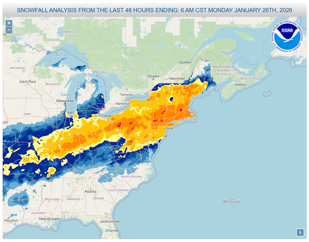
On 3/13/2026 at 12:16 PM, SACRUS said:
March 1993 storm
Wanted to share from SACRUS in NY forum.
-
A- Easton CT.
52.7 inches.
I grade purely on snowfall, with A+ reserved for 60+.
-
1
-
-
A- Easton CT.
52.7 inches.
I grade purely on snowfall, with A+ reserved for 60+.
-
1 hour ago, PhiEaglesfan712 said:
December (2024) and February (2025) were near normal. January being well below average made the winter BN.
This December, January, and February were all well below average. The first time since January, February, and March 2015. Of course, that was followed by a near record warm May.
December 2024 and February 2025 were officially below average.
-
17 hours ago, donsutherland1 said:
Generally cooler weather will prevail through the weekend. Following a soaking rain on Monday, a shot of much cooler air could arrive on Tuesday. Lows in New York City could fall to the middle and upper 20s with highs in the upper 30s and lower 40s on Wednesday and Thursday.
However, with the AO likely to remain generally positive, the cool period likely won't be as prolonged as had been the case during this past winter's cold regimes.
The major weather story next week will be the super March heatwave that will build in much of the western U.S. March monthly records are likely to be smashed in numerous cities.
The ENSO Region 1+2 anomaly was +0.9°C and the Region 3.4 anomaly was -0.1°C for the week centered around March 4. For the past six weeks, the ENSO Region 1+2 anomaly has averaged +0.80°C and the ENSO Region 3.4 anomaly has averaged -0.23°C. Neutral ENSO conditions have now developed. Neutral ENSO conditions will continue through at least mid-spring.
The SOI was +26.18 today.
The preliminary Arctic Oscillation (AO) was +3.365 today.
Based on sensitivity analysis applied to the latest guidance, there is an implied 76% probability that New York City will have a warmer than normal March (1991-2020 normal). March will likely finish with a mean temperature near 44.9° (2.1° above normal).
Supplemental Information: The projected mean would be 2.4° above the 1981-2010 normal monthly value.
Two years in a row of below normal Dec, Jan and Feb. Followed by above normal March.
-
1
-
-
23 hours ago, nycwinter said:
ahead of the storm in the northeast we had arctic cold, those are days long past by for mid march.
It was called a 100 year storm so unlikely to see again in our lifetime if they are correct.
The arctic cold was extreme for March even back then. As long as we keep seeing snow in April we sill still get snowy March months.
-
1
-
-
1 hour ago, donsutherland1 said:
Central Park: 78; LaGuardia Airport: 79; Newark reached 80.
The craziest part of that month was NYC received a 4.4 inch snowstorm in a sea of warmth
-
1
-
-
9 minutes ago, WeatherGeek2025 said:
72 at the park today!?
I think the record for this date was 77 in 2016. Can we break?
-
8 minutes ago, SHELEG said:
What about Feb 2018?
8 minutes ago, Brian5671 said:I would have thought Feb 2018 had an 80 in NYC?
Close on February 21 2018 it hit 78 (old record was 68 in 1930 which stood for 88 years!!!!)
-
 1
1
-
-
When will we break this one:
"The earliest in the year that New York City had a high temperature of at least 80 °F is March 13 which happened in 1990."
-
1
-
-
Not saying winter is over. We still have another window. However add another myth debunked to the list:
Debunked:
We no longer see benchmark storm tracks.
Added to the following Debunked myths:
Western pacific ocean temps mean constant MJO 456 phases.
NAO always connecting to the SE ridge.
Ocean temps mean the SE ridge is unstoppable.
Fast flow is now unstoppable.
Clippers are extinct.
-
4
-
-
1 hour ago, PhiEaglesfan712 said:
This is the Central Park in March 1994 leading up to the event:
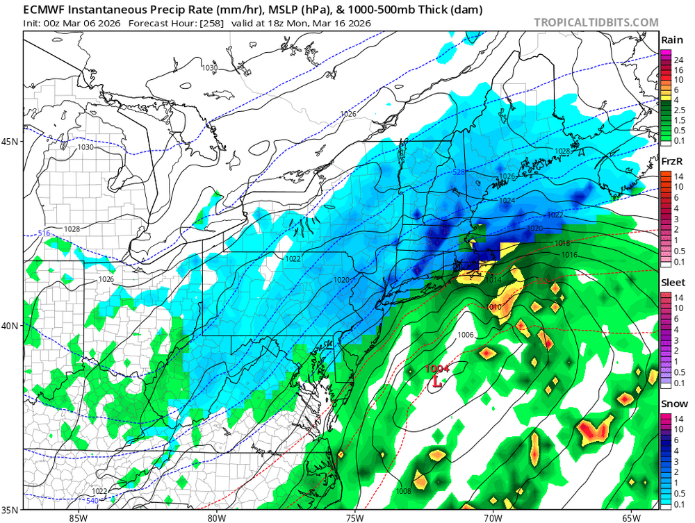
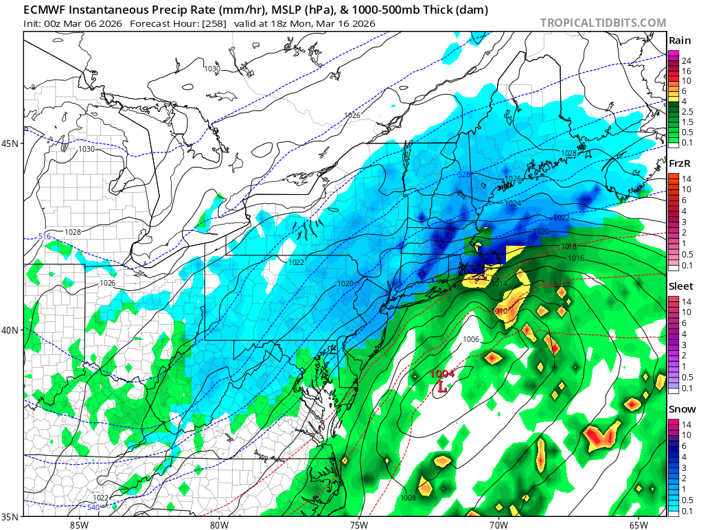
1994-03-01 38 24 31.0 -7.8 34 0 0.00 0.0 2 1994-03-02 30 26 28.0 -11.0 37 0 0.40 4.0 2 1994-03-03 35 27 31.0 -8.2 34 0 0.62 1.0 7 1994-03-04 48 30 39.0 -0.5 26 0 0.00 0.0 7 1994-03-05 45 34 39.5 -0.2 25 0 0.00 0.0 5 1994-03-06 42 30 36.0 -4.0 29 0 T T 4 1994-03-07 50 33 41.5 1.3 23 0 0.00 0.0 4 1994-03-08 48 35 41.5 1.0 23 0 0.12 0.0 1 1994-03-09 36 30 33.0 -7.7 32 0 0.29 T T 1994-03-10 46 32 39.0 -2.0 26 0 1.62 0.0 T 1994-03-11 47 31 39.0 -2.2 26 0 0.00 0.0 T 1994-03-12 46 26 36.0 -5.5 29 0 0.00 0.0 T 1994-03-13 52 33 42.5 0.7 22 0 T 0.0 T 1994-03-14 54 41 47.5 5.4 17 0 0.00 0.0 T 1994-03-15 55 41 48.0 5.7 17 0 0.11 0.0 T 1994-03-16 45 24 34.5 -8.1 30 0 T T 0 1994-03-17 37 21 29.0 -13.9 36 0 0.02 0.3 T 1994-03-18 33 25 29.0 -14.2 36 0 0.26 2.8 0 Highs were in the 30s, 40s, and 50s in the lead-up to the snowstorm. That is nothing like we have this year. Highs are going to be in the 70s the next few days. Unless you live in New England, you are not getting a snowstorm from here on out. The ground is just too warm and the sun angle is too high.
February, but in a sea of warmth we had a snowstorm. I mean 60s and 70s and it snowed.
It all has to do with intensity, track and cold air. Basically all the normal ingredients we just lose some light snow during daytime ability.
-
In keeping with the 1970s comparison;
1.) NYC hit 70+ three times in March of 1977:
March 10: 70
March 29: 78
March 30: 75
March 31 close with 69
2.) NYC hit 80+ three times in April 1977:
April 12: 85
April 13: 85
April 22: 83
Can we get as warm as 1977? Would be nice for a change.
-
1 hour ago, snowman19 said:
After the transient St. Patrick’s week cooldown, the ensembles are showing a big warmup coming again around the Equinox. If this is correct and the WPO goes positive along with a positive EPO, a big warmup is coming around the Equinox. There is nothing to stop it either….there’s going to be a raging +NAO and a +AO
Even it its 1 day all we need is a snowstorm to get NYC to 50 and Providence to the all time record.
A long window would not even matter that late in the season.
-
1
-
-
Way out there but this next window is the last to:
1.) Get CPK to 50 inches
2.) Give Providence their all time snowiest winter!!!!
Unlikely given that March only had 5 inches or more when December had the same FOUR TIMES since 1970.
-
This is interesting.
Only 4 winters starting with 1970 through last year had over 5 inches of snow in both December and March.
-
1
-
-
8 hours ago, PhiEaglesfan712 said:
Not really, recently all of our cold/snowy winters seem to be consecutive: 2002-03, 2003-04, 2004-05; 2008-09, 2009-10, 2010-11; and 2013-14, 2014-15.
Not recent, and the 2nd year was only 29.4 barely above average, however you can include 77/78 and 78/79 (77/78 also had 2 KUs, one of which mixed with sleet like this year and the other a bomb cyclone like this year).
-
10 hours ago, The 4 Seasons said:
I'd still like to know when, if ever, Jan 25-26th is coming. There are some pretty puny Cat 1s in that list so i have no doubt its obviously higher than a Cat 1. Has to be at least 2 or 3. I dont know if theyll ever do it, if they skipped right over to Feb
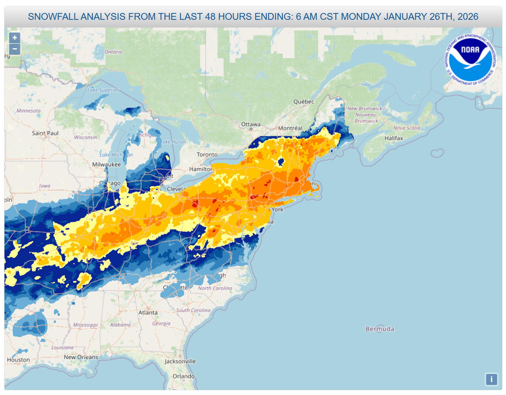
Thats a large area of 8-18 over major US cities
Yeah the effected population is off the charts and definitely more of an impact than the blizzard. It is odd that they have not released it yet.
-
2026-2027 Super El Nino
in Weather Forecasting and Discussion
Posted
I will be honest, I am looking forward to energy savings. Also, 2 of the last 3 super events had a KU event. Conscious that this is a very small sample size, however I would roll the dice winter with the active sourhern jet.
Perhaps I am just greedy after the tri state area experienced 2 KU events this past winter.