

EastonSN+
-
Posts
6,846 -
Joined
-
Last visited
Content Type
Profiles
Blogs
Forums
American Weather
Media Demo
Store
Gallery
Posts posted by EastonSN+
-
-
4 minutes ago, SnowGoose69 said:
Remember the usual rule, 20-30 miles N of where most models show...most show best banding between around TTN and Toms River roughly so perhaps you focus on Perth Amboy/SI south to about Lakehurt for the best chance of banding here as of now....S shore of Queens/Bklyn/W LI might be able to get in on it with a slight north shift
I live in SW CT!!
-
3k snow map is more Robust.
-
 1
1
-
-
59 minutes ago, donsutherland1 said:
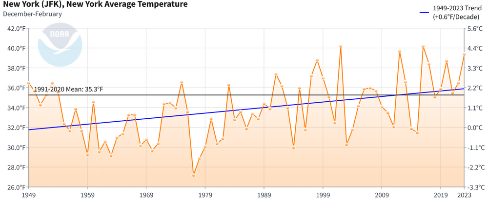
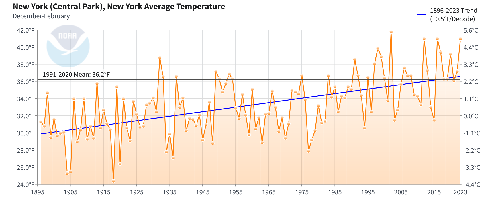
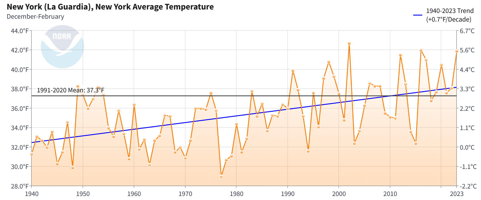
While the region will see light snow late tonight into early tomorrow and a brief shot of colder but not exceptionally cold air, Central Park remains on course for its case with two consecutive winters with an average temperature of 40° or above. The closest such two-winter period was 2015-16 (41.0°) and 2016-17 (39.3°). LaGuardia Airport actually had winter mean temperatures of 40° or above in both those winters. Central Park's period of record goes back to 1869.
40° or above winters are largely a recent phenomenon in the New York City area and the region's winter temperature has been warming.
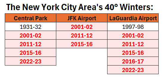
The periods of record for the above stations begin as follows: Central Park: January 1869; JFK Airport: July 1948; and, LaGuardia Airport: October 1939.
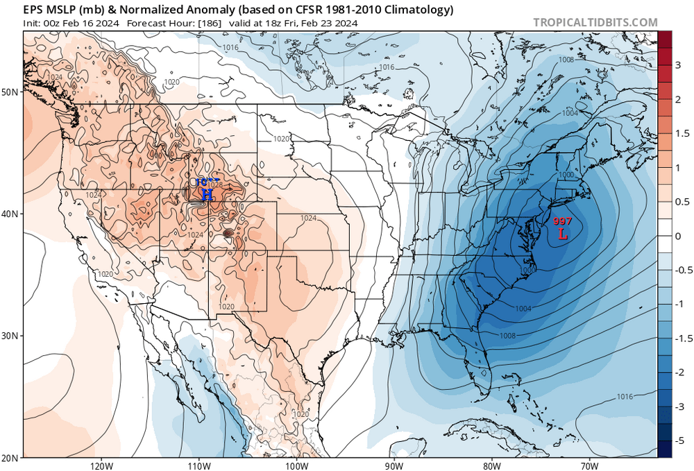
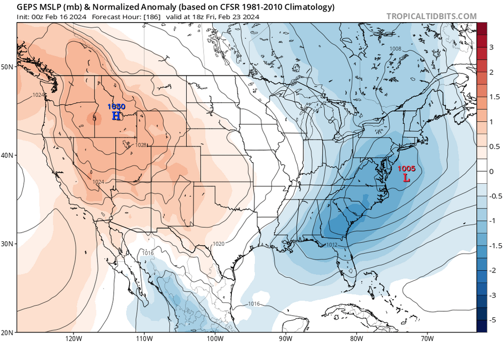
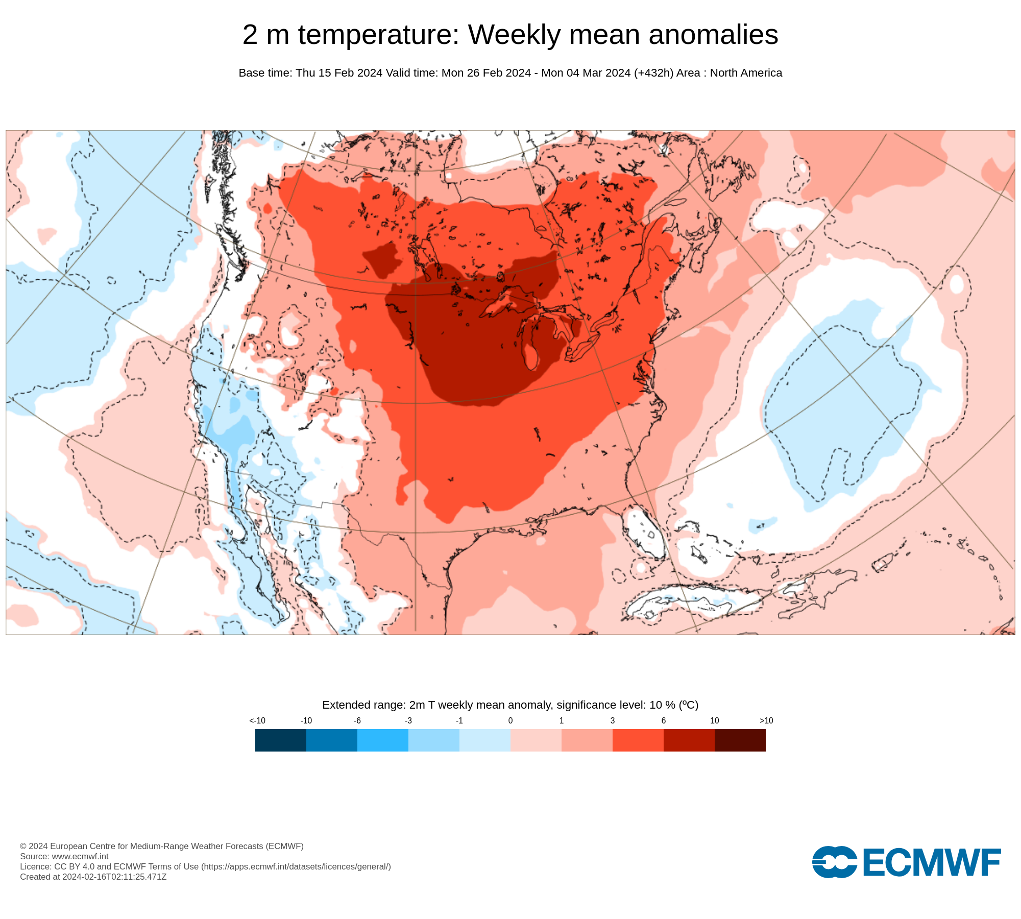
Previously, the CFSv2 and ECMWF weekly guidance were in strong agreement that a colder, but not severely cold pattern would continue into at least the first week of March. However, as the month advanced, that support on the guidance collapsed and a late February warmup more consistent with strong El Niño winters gained support.
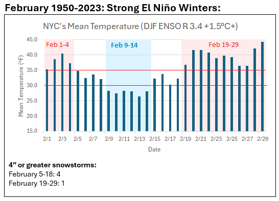
The latest weekly guidance shows a very mild close to the month, which makes a 40° or above winter average temperature likely at Central Park and LaGuardia Airport. Both the 2/16 0z EPS and GEFS show February ending with high temperatures of 50° or above.
ECMWF Weekly Forecast:

CFSv2:
All three locations are experiencing a sustained warming of winters:
Central Park:
JFK Airport:
LaGuardia Airport:
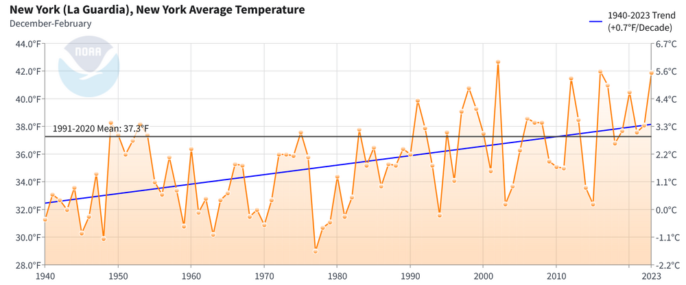
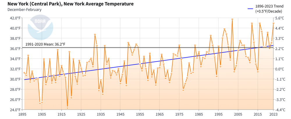
As the warming continues, 30-year mean winter temperatures will likely cross the 37° threshold at which Mid-Atlantic locations south of the New York City area experienced a long-term decline in seasonal snowfall. Through Winter 2022-23, the 30-year average winter temperature in Central Park had reached 36.2°. Following Winter 2023-24, that figure will likely stand at 36.5°.
The climate models suggest that New York City will reach the 37° winter temperature average by the middle 2030s. That would result in 30-year seasonal snowfall declining to around 20". The very recent low snowfall winters are likely a combination of a bad cycle within internal variability and consequence of growing background warming. Therefore, it is possible that New York City is in the very early stages of a transition toward a lower snowfall state. Even in a lower snowfall state, there will still be snowy winters, but those winters will become less frequent. Winters lacking much snowfall (10" or below) will grow more frequent.
As for this winter, it remains to be seen whether Central Park will record its first case of two consecutive winters with less than 10" of snowfall. Many strong El Niño winters have seen at least some measurable snowfall in March. Since 1950, there were three that did not: 1966, 1983, and 2020. 1983 had measurable snowfall in April.
Thanks Don. It will be interesting for CPK, if the clipper can come just close enough, they will be extremely close to 10 with a little more than a month to go. Pattern is hostile after the 26 however there seems to be one more threat before it arrives.
-
The winds aren't exactly off the water, however, this is where warmer water temps/higher dew points can help us!
We lose a little snow on a storm like the last, we gain a little potentially in a storm like this.
-
1
-
 1
1
-
-
17 minutes ago, EastonSN+ said:
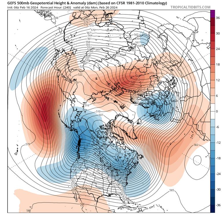
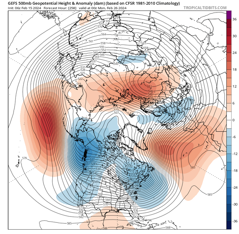
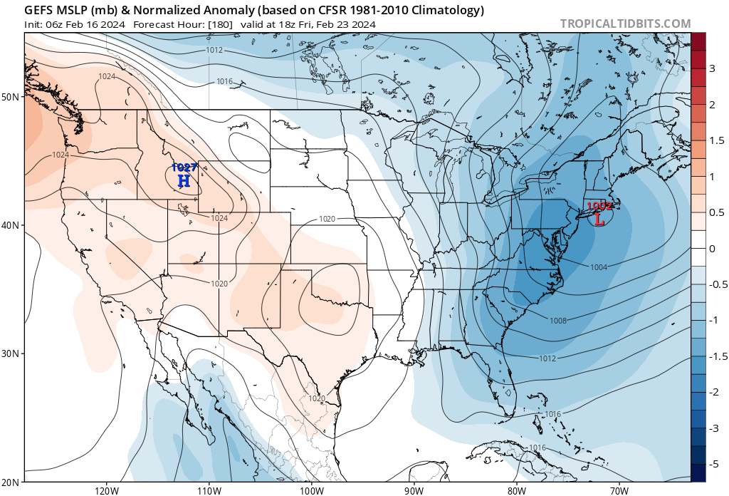
Would need to hold intensity and not gain latitude (ie GEFS) for any chance, however something to track.
-
 1
1
-
-
Sometimes small things can make a good winter vs. a low snowfall one.
Fast PAC not allowing this to gain latitude/ northern stream too far ahead. The way it goes sometimes.
-
2
-
-
Would need to hold intensity and not gain latitude (ie GEFS) for any chance, however something to track.
-
2
-
-
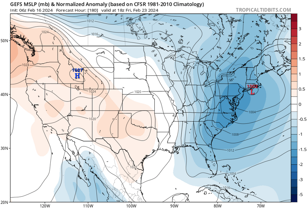
Looks like our window ends approx the 26th.
-
1
-
1
-
-
1 minute ago, LibertyBell said:
2002-03.... that's such an underrated winter that did well for a lot of people.
PD2 was also extremely underrated, rarely do you see a storm dump over 2 feet of snow in Baltimore, JFK AND BOSTON.
Those kind of widespread snowstorms seem to have become an endangered species.
That's what was special about PD2 and 2002-03 was snowy right from December through April.
True megalopolis snowstorms happen approx once a decade (83/96/03/16). Hope we get one this decade too!
-
1
-
-
Really happy to see clippers back from extinction. Hopefully it's not just a MA special.
-
1
-
-
3 hours ago, brooklynwx99 said:
most of it was the storm earlier this week not cutting, so we missed the main wave break that set everything in motion. the Scandinavian ridging also crapped out. really bad luck on both fronts, and it's probably the most complete failure on medium to long range modeling I have seen in quite some time. a shame
I think you were great. More often than not things do not work out on the snow front in this part of the country outside of 2000/2018. We will get em next year!
-
2
-
-
More moisture more chance.
-
2
-
-
On 2/11/2024 at 10:50 AM, Allsnow said:
Probably never see this again…
Probably not, but perhaps instead of 12 degrees and snow it will be 14 or 15 degrees with snow? Higher temp on that thing could mean more snow, less dry air at the start
-
49 minutes ago, bluewave said:
2015-2016 was the real outlier. All the rest of the Decembers with under 1” of snow since 1950 had below average seasonal snow in NYC. This season is continuing that pattern.
Monthly Total Snowfall for NY CITY CENTRAL PARK, NY
Click column heading to sort ascending, click again to sort descending.YearNovDecJanFebMarAprSeason2011-2012 0.0 0.0 4.3 0.2 0.0 0.0 4.5 2006-2007 0.0 0.0 2.6 3.8 6.0 T 12.4 2023-2024 T T 2.3 3.2 M M 5.5 2022-2023 0.0 T T 2.2 0.1 0.0 2.3 2018-2019 6.4 T 1.1 2.6 10.4 0.0 20.5 2015-2016 0.0 T 27.9 4.0 0.9 T 32.8 2001-2002 0.0 T 3.5 T T T 3.5 1999-2000 0.0 T 9.5 5.2 0.4 1.2 16.3 1997-1998 T T 0.5 0.0 5.0 0.0 5.5 1996-1997 0.1 T 4.4 3.8 1.7 T 10.0 1994-1995 T T 0.2 11.6 T T 11.8 1972-1973 T T 1.8 0.8 0.2 T 2.8 1971-1972 T T 2.8 17.8 2.3 T 22.9 1965-1966 0.0 T 11.6 9.8 T 0.0 21.4 1953-1954 2.2 T 12.7 0.5 0.1 0.3 15.8 Did we have snow December of 2014?
-
36 minutes ago, Stormlover74 said:
Can always squeeze out a nighttime event in between periods of warmth
Yeah wavelengths shorten and bowling ball systems can occur, however overall pattern sub par.
At least DC and Baltimore have a legit shot at average annual snowfall with the next statem.
-
On 2/9/2024 at 11:26 AM, ORH_wxman said:
2013 might be #2 all time in CT behind 1888. What a ridiculous coverage of 25”+.
My 2nd favorite all time behind the blizzard of 1996. I was in Norwalk at that time WEST of the heavy band and still picked up 22 inches. My dad two towns east of me in Fairfield recorded 35.
Only beaten by 1996 since Norwalk received 27 inches that storm.
-
1
-
-
Looks like our window MAY be extended to the 26th. However, no current threat after this weekend.
-
3 hours ago, bluewave said:
You can quote my whole post from above if you like. But I don’t want to get misquoted in one of our other regional forums.
You received lots of respect in the New England forum, and a great discussion ensued.
-
1
-
-
29 minutes ago, 40/70 Benchmark said:
What he says makes sense in theory and I respect the fact that he is open to something altering the regime. He is not at all a troll. Very bright and grounded guy. Having said all of that, I remain of the opinion that Mother Nature will find a way to balance the scale, so to speak, at some point.
100% agree
-
16 minutes ago, bluewave said:
It’s not about setting anyone straight. Not sure why I keep getting quoted multiple times when I am not in that thread. But I have looked at the responses and statements and have some replies. First, we have never had 9 consecutive winters this warm in the Northeast before. One of the dominant themes is that the rapid expansion of the WPAC warm pool has lead to more forcing from MJO 4-7 which had been written up in numerous studies. Forcing in this region is warm for the Northeast. So it makes perfect sense that it has been this warm in our region over the last 9 winters. I never said that we couldn’t eventually see another colder than average winter in the Northeast. Just that as long as this WPAC warm pool remains so prominent, it will probably load the dice for more warmer than colder winters over time. I am not sure what could shift this but would be open to a change if some new region of tropical forcing can emerge.
The reduction in the snowfall has occurred a little later beginning with the 18-19 season. It has resulted in 5 out of the last 6 winters with below normal snowfall in NYC. It seems to be a combo of warmer than normal winters and the more hostile Pacific patterns. The epic 2010-2018 snowfall period carried over into the beginning of the warm winter period that started in December 15 with the historic +13.3 departure. My guess is that the 2010s will stand as our snowiest recent decade. When the 2020s are complete , we are on track for a significantly lower snowfall period vs the 2010s even if snowfall can improve next several seasons. But this doesn’t mean that we can’t have some great snowfall seasons in the mix like 20-21 along the way. Snowfall has been more variable while winters have been steadily warming over the years.
Second, the warm blob in the NEPAC from 13-14 to 14-15 was the result of tropical forcing and not the direct cause of the pattern. This pattern quickly shifted after 2 years during the winters but became prominent in the warm season. It was a direct result of the tropical driven Rossby wave pattern. The record PAC NW heatwave a few summers ago and numerous Western drought seasons with the powerful Western Ridge were part of this pattern. An interesting question for study is why the seasonal shift occurred after the 13-14 and 14-15 winters?
Feel free to quote this post if you like.
I don't think you were posted, it was a discussion between Forky, Tip and ORH.
-
48 minutes ago, ORH_wxman said:
MJO is the latest fad to explain a small sample size of outcomes IMHO. We’ve seen it for decades now.
- Late 1990s literature blamed the big reversal of NAO/AO to predominately positive phases on CC
-early 2010s literature blamed the big flip back to -AO/NAO on CC via melting sea ice
- mid-2010s literature blamed the western drought and cold eastern winters in the pacific warm blob due to CC
I remember being called a climate denier for being skeptical of the sea ice theory circa 2012 or so. It’s hard to have rational discussions about these attribution studies with people who don’t really care about rigor.
MJO is popular right now because “it makes sense” in explaining a small sample of shit winters in the east. To your point, maybe the MJO stuff is true in a vacuum but people are over-attributing the MJO to our own weather.
What is going to be the next explanation when we get a couple of cold-loses winters in a row?
IMO ORH_wxman and Forky two of the best posters.
-
 1
1
-
-
2 hours ago, forkyfork said:
maybe the huge area of near 90 degree water in the west pac will magically cool down despite co2 emissions not dropping
1 hour ago, ORH_wxman said:2015: “the west coast pacific warm blob isn’t going to magically cool”
2024: “the tropical pacific warm blob isn’t going to magically cool”
Sorry Forky just for fun. Good discussion though in the NE thread.
-
5 minutes ago, LibertyBell said:
Sure, there's still a chance, but so far how would you grade this winter?
I'd say D-. Last winter was an F (I don't think there is an F-). If we get a storm of 6"+ (doesn't even have to be 10"+ because we already have had a 4" storm), I would raise it to C-.
I would grade it as a D-.
0 to 9 inches - F
10 to 19 - D
20 to 29 C
30 to 39 B
40 plus A.
-
1
-
-
1 minute ago, LibertyBell said:
See above post, we had much better blocking in those winters, with the changing climate, those blocks are not happening as frequently, specifically after 2015-16 we saw a complete change to the Pacific Ocean that we still haven't recovered from.
Again that's 50%. You left out 97/98.
Also are you certain we can't get another 15/16 or 82/83? The IO temps are rising fast and that correlates to phases 1 and 2.


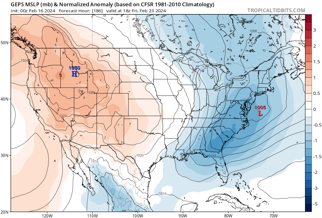


Refresher snow & obs between ~midnight and Noon Sat Feb 17 2024
in New York City Metro
Posted
Really shows the two bands that were previously discussed. One over Delaware near the rain line and the other basically li NYC and Jersey.