Local Yokel Wx
-
Posts
735 -
Joined
-
Last visited
About Local Yokel Wx

-
2023-2024 Fall/Winter Mountain Thread
Local Yokel Wx replied to The Alchemist's topic in Southeastern States
chiming in from the sidelines, been too long. good luck everybody! Congrats TN valley folks, love this look. -
Late to the party, but picked up 0.10" of snow Thur PM - Fri AM Season Running Total: 9.4" 1/3/22 -> 1.8" 1/16/22 -> 7.5" 1/21/22 -> 0.10"
-
Winter Storm Izzy Obs Thread
Local Yokel Wx replied to Prismshine Productions's topic in Southeastern States
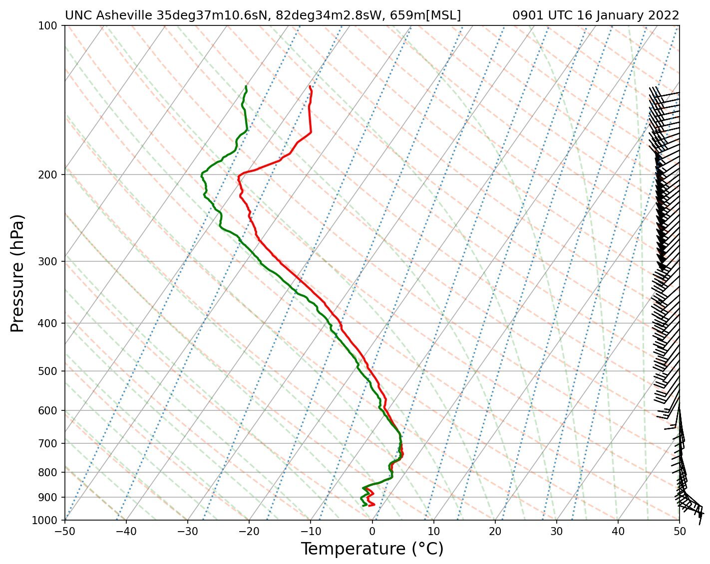
From Evan Fisher and the gang at UNCA 09z sounding from UNC Asheville / next one at 12z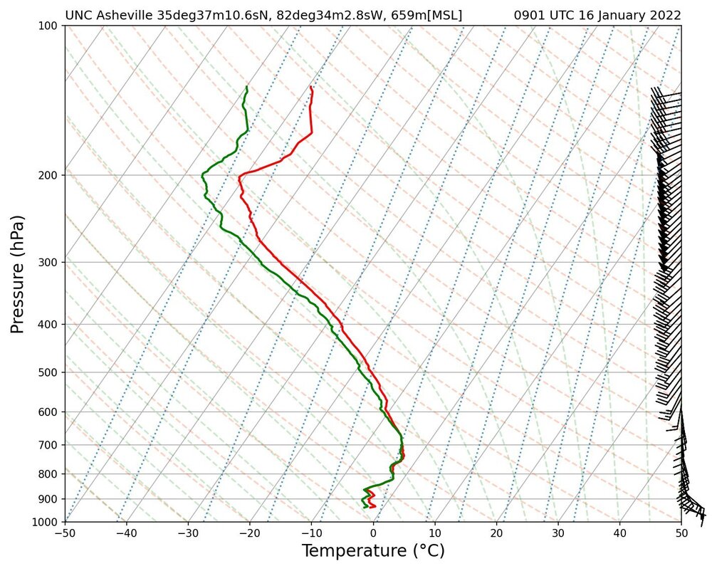
-
Winter Storm Izzy Obs Thread
Local Yokel Wx replied to Prismshine Productions's topic in Southeastern States
Waynesville PXL_20220115_232804004 (2).mp4 -
true and agreed. I should have mentioned SW NC as our area.
-
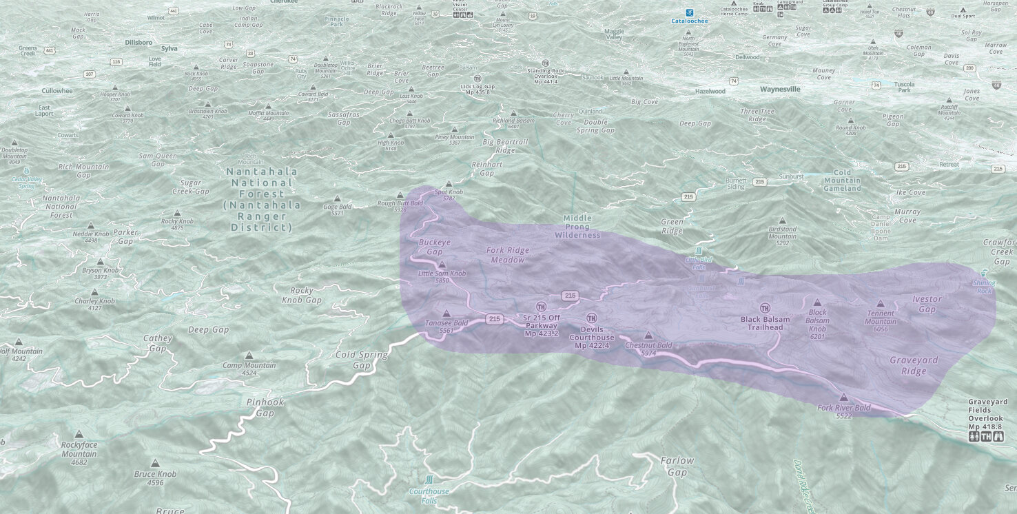
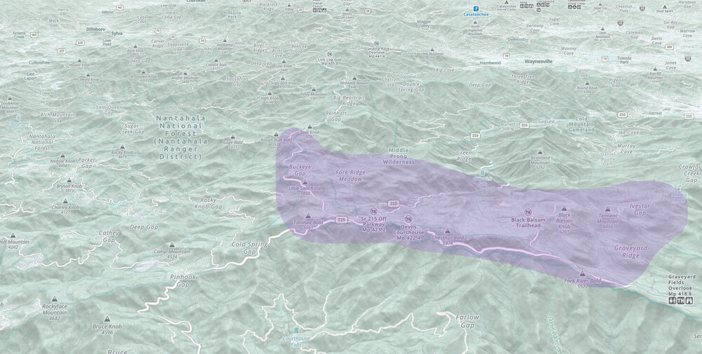
Several friends are running up 215 to hike and ride out the storm along the southern portion of the Great Balsams. This will likely be the spot for the highest totals in our area
-
2021-2022 Fall/Winter Mountains Thread
Local Yokel Wx replied to BlueRidgeFolklore's topic in Southeastern States
1.8" storm total. Not too shabby. -
2021-2022 Fall/Winter Mountains Thread
Local Yokel Wx replied to BlueRidgeFolklore's topic in Southeastern States
Crossroads cam looks solid with 1 - 2" on the ground, same for Highlands but looks a bit more (6am) Someone i follow on twitter (and encouraged to join the forum) is out of Yancey at 4500', 1/2 mile from the TN line and is reporting 7" as of 6am. 2" here in the valley (Waynesville), about a mile from downtown the way the crow flies. Congrats everyone! -
2021-2022 Fall/Winter Mountains Thread
Local Yokel Wx replied to BlueRidgeFolklore's topic in Southeastern States
One of the many reasons we moved from Jackson to Haywood was the weather. I was tried of being burned by winter storms in the deeper valleys of SW NC, that and a touch cooler in summers. Although I am a fan of rain and the Plateau is something special. Highlands and many other sites surpassed 100" of rain on the year, for the fourth year in a row. -
2021-2022 Fall/Winter Mountains Thread
Local Yokel Wx replied to BlueRidgeFolklore's topic in Southeastern States
Two storm chasers locally will be camping out along Carver's Gap to live stream (hopefully) blizzard conditions. I wouldnt worry about their safety, these two know what they are doing. -
2021-2022 Fall/Winter Mountains Thread
Local Yokel Wx replied to BlueRidgeFolklore's topic in Southeastern States
The GSP AFD mentions thundersnow... "Thunder snow will be possible as well due to the dynamics of this system and the development of instability within the core of the system." -
2021-2022 Fall/Winter Mountains Thread
Local Yokel Wx replied to BlueRidgeFolklore's topic in Southeastern States
Picked up 0.97" in roughly two hours. Woke up to the rumble. -
2021-2022 Fall/Winter Mountains Thread
Local Yokel Wx replied to BlueRidgeFolklore's topic in Southeastern States
I run a snowmaking business and its been an insane year for snowmaking hours here in the valley (Waynesville). We've had more snowmaking hours than Cat this season, in particular during December with so many inversions the last few weeks. Check out Latitude 90, they are likely to be the new norm for snowmaking at slopes like Cat; internal snowmaking, thrown out from the container. Link: https://latitude90.ca/ Rooting for you up Crabtree for Sunday night, looking good for northern Haywood. -
2021 Spring/ Summer Mountains thread
Local Yokel Wx replied to Met1985's topic in Southeastern States
Highest official total so far is out Lake Toxaway at 17.36" (CoCoRaHS) Cruso FD picked up 14.17"; 5.28" in just 3 hrs Tuesday (9" for the day), which is the cause of the flash flood down East Fork and into Canton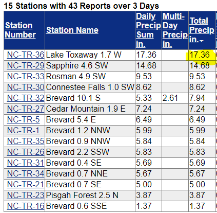
- 310 replies
-
- 1
-

-
- late freeze
- warm
- (and 3 more)
-
2021 Spring/ Summer Mountains thread
Local Yokel Wx replied to Met1985's topic in Southeastern States
Rainfall Totals Sun 10am - Tues 11am northwest Transylvania County Cold Creek - 10.59" Balsam Grove FD - 8.9" Rosman - 6.72" southern Jackson County Rock Bridge - 9.13" Wolf Creek (lake) - 8.31" Robinson Creek - 5.39" southern Haywood County Cruso - 7.64" Data: FIMAN/NC EM- 310 replies
-
- 2
-
-
- late freeze
- warm
- (and 3 more)