North Balti Zen
-
Posts
11,808 -
Joined
-
Last visited
Content Type
Profiles
Blogs
Forums
American Weather
Media Demo
Store
Gallery
Everything posted by North Balti Zen
-
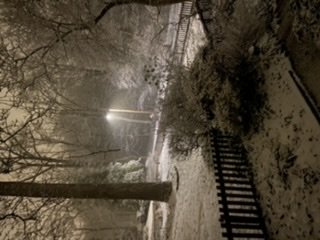
Two quick things for up this way: 1. The trees and pretty much everything else (chain link fences, sides of buildings, dogs who move too slow) are absolutely plastered in snow still. It is unbelievably gorgeous. Most of it fell here right around 32 degrees or just a hair under, and then it stayed crazy overcast today and temps held around 35 or under and everything is still plastered. I've rarely seen it quite this pretty up this way for this long. It looks like Vermont amongst the trees. 2. On that note, trees and limbs are already bowing, at least one tree was down from the snow weight on my walk just now, and the temp isn't really going anywhere over the next 36 hours until the theoretical Saturday ice event. If it hangs on the trees like this until then and we actually get an ice event, there will be trees/limbs down and power line issues. Guessing even with cold temps tomorrow the sun will help head some of that off.
-
you wanna know what is even crazier? If memphis actually can get 6+ inches from that. I lived there from 1996 - 2009. It was EXCEEDINGLY hard to get real snow into Memphis. They were forever missing it in all directions but just a county or two. A foot of snow there with cold temps would be crippling.
-
For the record, you can be REALLY IMBY-centric. Union Bridge is likely out for tonight - but for DC south a bump north really helps them. Fingers crossed for that crew.
-
Mid-Atlantic Winter 2020-21 Snow Totals
North Balti Zen replied to George BM's topic in Mid Atlantic
12/16-17: 3.8" 1/26: .2" 1/31 - 2/2: 5.1" (4 inches day 1, remainder over next two days of the event) 2/7 - T (pretty much a total bust) 2/10 - 2/11 --- 4.2" Season total 13.3" -
Very much a "you come at the king you best not miss" moment...
-
Yeah - I was at 3.5 at 3:45 am and only got to 4.2. Looking at radar per my post at the 3:45 measurement you can see I read the radar wrong and thought we would have several more hours of good rates. me reading a radar wrong is...not a new development.
-
Finished with 4.2”. So close but so far to hitting warning level here but no complaints. Everything is caked in snow - it is beyond gorgeous out. Literally looks like the world is covered in frosting. Maximizing an event here for change was fun.
-
11:00 pm — 1” 3:45: am —- 3.5” still moderate snow. Not a breath of wind. Snow plastered to everything. Pretty sure looking at radar that we get warning level snow verified here in my hood without a warning to break the drought which is cosmically hilarious. appear to be breaking our bad luck run at lest for my hood with a whole bunch of unlikely luck —- namely, off top of my head, cashing in on a narrow band of good snow returns, started at 8:00 pm and fell during overnight , important because it was just under 32 here and needed all the help we could get to hold snow and not mix, and long fetch of snow with enough duration to make this work. bizarre. only pause is this was such a narrow win, frustrated that rest of our mid -Atlantic crew in forum didn’t cash in too.
-
Sorry to hear on the snow - hoping some rates and cold air still work in overnight for you all. This whole region is always on such a knife's edge with snowfall...
-
happy to report moderate snow and 1" of actual honest to god accumulation. Best snowflake growth for Balt City this year. Gorgeous out.
-
Made me look, he did indeed. End times, man, end times.
-
You should be good with a flip shortly. Went from misty nothing to nice dendrites here in last 15 minutes.
-
Confirm legit light snow underway here now - sidewalks and roads a quick cave
-
Thanks. Was about to summon the ghost of Leonard Nimoy and his "In Search Of" intro for my efforts find dendrites...
-
It's pretty much sleet/graupal here at the moment.
-
Rooting like hell for the DC crew on this.
-
Flurries in my part of Balt City - it begins. Yay!
-
That does feel like once in a lifetime type stuff.
-
Right. @Baltimorewx agreed.
-
This isn't that early, no. Over my way the main event (assuming there is such) was supposed to be here by around 9 pm give or take.
-
37/25.
-
Heh.
-
Seriously worried for DT's mental health with his beloved Euro taking another header...
-
38/26 in my part of Balt City. Glancing at radar, trajectory looks...decent (for DC north folks) for where precip is currently occurring?