

NEOH
-
Posts
3,366 -
Joined
-
Last visited
Content Type
Profiles
Blogs
Forums
American Weather
Media Demo
Store
Gallery
Everything posted by NEOH
-
The band was impressive as it moved through. Surprised it moved south so quickly. Figured there would be more convergence with the sw winds over land. Good to see the radar starting to fill in over the lake though.
-
Great pics. We've had two straight seasons where the lakeshore areas have been favored. The next two days look snowy with a potential lake Huron connection. Let's just hope we are not left wondering what could have been if use lake was a just a few degrees warmer. I'm cautiously optimistic for a big event... But how much the ice effects things is the big caveat.
-
Thanks for the forecast ohweather. Looks like a spread the wealth event. I was downtown yesterday afternoon. There was open water but lots of ice starting to form along the shoreline. Hopefully there is enough juice for this event.
-
Had around 2" of new snow last night. Slowly but surely scraping our way to a decent snowpack. Looks like another fairly significant LES event coming up for areas favored by a west flow - what's new! Pretty amazing that we've haven't had one significant WNW flow LES event this year. The ice is rapidly expanding so time is running out.
-
Surprised they show so much precipitation. But there is agreement in the 12z run. Maybe we make a late rally.
-
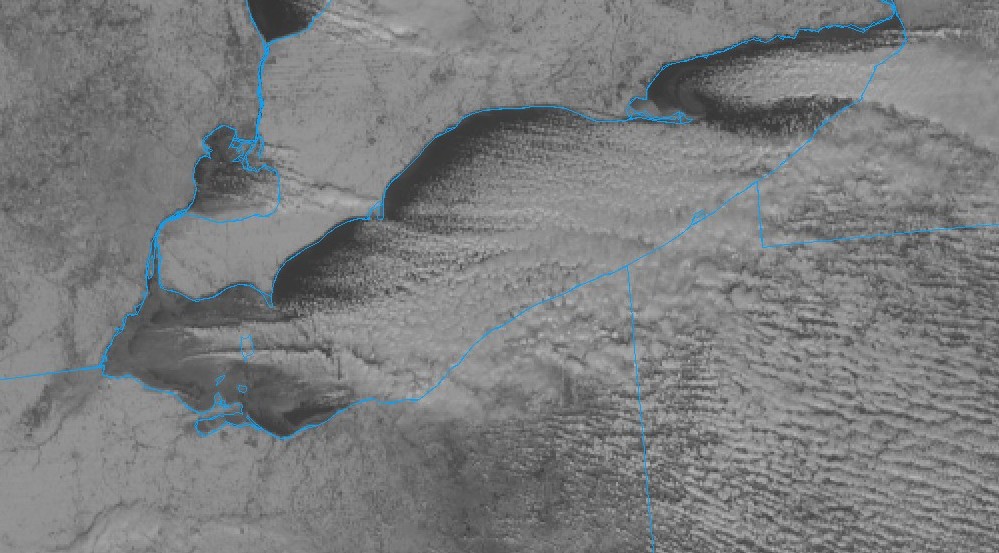
Awesome view from GOES. Lots of ice now expanding into the central basin.
-
There's a nice band forming now. Not sure if it is convergence related to the WSW winds over land and the WNW winds over the lake. Hopefully the band doesn't swing too far to the northeast though.
-
Ha! We are used to disappointment. Looks like winds are turning more WSW'erly over the lake as the bands are starting to move to the NE up the shoreline. Maybe it's temporary but I had thought winds were going to come around more NW'erly as the day went on. Fetch is being maximized and it appears a more intense single band may form. We'll see what the afternoon brings if that can get organized.
-
Yeah, that's a tough one to take. LES is so localized. Hopefully we can all share in a decent WNW wind event prior to the lake freezing. Time is running out though.
-
A very fine snow coming down. Maybe an inch so far. Temps are just too cold. Anyway, nice to see the snow falling. Erie PA is at 100" of snow for the season, while CLE is just short of 12". What an amazing gradient.
-
That's amazing. Wish the radar was better in that area. Looks like the rich will get richer. We are dealing with heavy clouds in Geauga County... That's about it. Might be able to squeeze out of couple of inches tonight/tomorrow if we are lucky enough. It just doesn't seem possible to get a wnw wind direction.
-
It will be interesting to see what happens later tonight. 290 would be an ideal flow... But with weak winds I think the band will have a hard time pushing this far inland. Who knows... Maybe we'll see an inch or two as the band decays and pushes off to the southwest with the turning winds. Ice has rapidly formed on the western basin so that fetch will be lost by tomorrow. Don't mean to sound so pessimistic but what a waste the cold has turned out to be locally.
-
Nice band over the lake. The second secondary band that formed seems to be taking over. If only it would make it this far south. Thinking it may be a shutout for areas south of 322.
-
1.7 round one, and 1.6 overnight.
-
Thanks. Ouch! Painfully close. If those verify I can drive a couple miles north to see a foot of snow.
-
Merry Christmas. Yeah, hopefully the band can shift south at some point. It won't take more than a cold and calm night to freeze the western basin. The wrf doesn't seem to be updating. Yesterday runs brought the band very close.
-
Not overly optimistic about snowfall. Just about all of the guidance has the heaviest snow north over the lake. And, the lake effect behind the system looks to set up well northeast given the wind direction. We just can't get a decent wnw wind direction. Hope I'm wrong but 2-3" is my call at least locally.
-
12z euro was a nice run... shows 4-5 inches of snow by/on Christmas. Not a bad look afterward as well.
-
Could be an interesting Christmas eve/day. 12z guidance looking good for a white christmas.
-
Interesting model trends for the Christmas eve storm. 12z NAM has a 999 low on the MD, PA, WV border... typically a good position for Northern OH. Just need the cold air to come in a little sooner. Yeah, its the NAM and just one model scenario... but we'll see what the others show later on.
-
Nothing but patches and piles left this morning. I wouldn't rule out a synoptic system on Christmas day. LES seems destined for WNY again... but a long way out at this point so lots can change. Trent hasn't posted in a long time. Wonder if he moved away from the area.
-
The snow should be gone in another day or two. Awful timing. Hopefully we'll see some positive trends in the models soon.
-
Now that is just over a week since the cold set in here are the updated lake temps. Ice has formed near the shoreline around the western basin.
-
The 12z WRF paints a snowy picture for lake, northern geauga and ashtabula. Once again the heaviest snows will be northeast of here, but they do show a little snow down this way.
-
It will be interesting to see how far south the band comes. The wrf-arw is the southern most at this point.

