

NEOH
-
Posts
3,366 -
Joined
-
Last visited
Content Type
Profiles
Blogs
Forums
American Weather
Media Demo
Store
Gallery
Everything posted by NEOH
-
The GFS weenie runs continue... with multiple storm chances for the OV region. The Euro looked good as well. We have the brief (and light) LES event tonight/tomorrow, clipper Sunday, and the mid-week storm on the table. Great to have an active pattern for a change.
-
The WRF has the band as well. The arw is NE of here, and the nmm is about the same location as the NAM. It will definitely be driven by an upstream connection which is a wild card.
-
Looking forward to a more active pattern. Hopefully it delivers for the lower lakes region. Noticed that CLE's snowfall total looked low compared to surrounding areas. Not surprising I guess. You can really notice the lengthening days. Over 10 hours of daylight now... about the same amount of daylight as November 9th.
-
If we could only keep some open water on the lake we'd probably see more of these events throughout the winter.
-
My measurement was probably off as it sounds like most came in with around 8". Still getting some decent bursts of snow.
-
I measured 6.2" at 6:30am. There is some drifting so may not be exactly accurate. What a nice surprise... lake enhancement definitely helped. We spend days tracking events that rarely deliver... this was one of the better short terms storms we've had.
-
Snow is just starting to come down in Chagrin. Nice flake size. Temps are just above freezing though. We'll see what tonight brings.
-
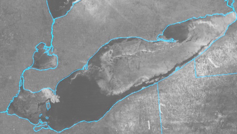
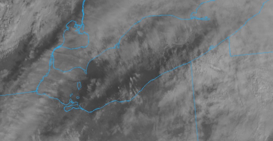
Nice view of the lake today, and snow cover in Northeast Ohio which will likely be gone by later today. Lots of open water over the lake as most of the ice has shifted up the lake. Let's hope we can get a few chances for LES once the pattern changes. Its starting to feel like late winter already for some reason.
-
That's really cool.
-
Looks like Winter will take a hiatus for awhile. Who knows how long but hopefully it warms up enough to melt some ice on the lake. It has been a good 1st half of Winter so far. We've nickeled and dimed our way to a decent snowfall total. Might be a stretch to get to average if we have to rely on synoptic systems.
-
Waiving the white flag on this one. Radar is unimpressive with a bit of a sucker hole over the area... Not to mention the snow already dissipating on the nw side. 2-3 may be a stretch.
-
Check out the mesoscale disco in the storm thread. And yeah... the HRRR is reeling back to the west.
-
That's a pretty healthy precip shield moving north. Seems to be favoring the eastern row of counties though. Wonder if the precip shield will condense or stay fairly ragged throughout the event.
-
Surprised the lakefront hasn't flipped over. CLE was reporting light snow. Starting to accumulate here. We are at a higher elevation... but not sure that makes a difference.
-
I don't think it's going to be too much longer before the flip to snow. The precip turned over to mainly snow under the heavier returns which moved north. Radar is filling in the south now. Edit: As of 1:45 its all snow IMBY. There is a good chunk of moisture coming up from southern ohio. Looks like it will make a run for the eastern counties.
-
Heavy ice pellets in Chagrin. Wonder how long the change to snow will take.
-
Thanks for the info. The low looks good down south. Wonder if that could be enough to slow down the shortwave. Oh well. This storm has been a mess to track. Edit: 34/33 IMBY. That didn't take long.
-
Bummer. Can you elaborate? Edit: 12z NAM's weren't that bad. That low take a sudden jog east though.
-
Nice forecast. The models continue to waffle back and forth on snowfall amounts...but the trend pretty clear that areas to the east will see the heaviest snows. Where's that last minute NW shift when we need it?! Didn't take very long to melt all the snow so we will be starting fresh. Even the piles are almost gone at this point. Look forward to seeing what happens later today. What is causing the the low to shift to the EC when it hits PA... The northern stream energy pushing down?
-
Nice view up there! Even better not to see ice. The southerly winds have probably pushed to the canadian shoreline. The snow is just about melted here and the rain tonight should finish things off. This has been a strange storm to track. Thought it was going to be a true apps runner but has evolved into a weak low riding a cold front. We'll see what happens.
-
CLE issued a WSW. Surprised they are calling for a 1/4 inch of ice. That would explain the lower snowfall totals. 6-8" of system snow on top of that much ice wouldn't be good. ..WINTER STORM WARNING IN EFFECT FROM NOON FRIDAY TO 10 AM EST SATURDAY... * WHAT...Heavy mixed precipitation expected. A glaze of ice up to a quarter of inch is expected Friday afternoon, then accumulating snow later Friday and Friday night. Total snow accumulations will average 3 to 6 inches outside of the snowbelt and 6 to 8 inches in the snowbelt. * WHERE...Portions of northwest Pennsylvania and northeast Ohio.
-
Its not often we hope for a NW bump with a storm... usually hoping for the opposite. I kind of like where we sit at this point. Given the dynamics its hard to believe we aren't seeing a stronger storm on the models... but I'm no meteorologist. In addition to the track and intensity the models seems to be expanding and contracting the precip shield with every run. I have very little confidence either way. Just a guess but I'd go with 5-8" for areas east of 71 in northeast ohio. I do think that lake enahncement will boost totals in the lakeshore counties. Hoping we don't waste a lot of the precip on sleet.
-
Clouds cleared out enough to get a decent view of the lake. Lots of open water out there. Hopefully lake enhancement can boost what looks to be our dwindling snowfall potential.
-
The snow cover is starting to get down to patches. Temps held around 47 IMBY all night. Surprised to see CLE at 56 this morning... that's a pretty large temp spread. Speaking of spreads, here are estimated snowfall totals from the latest model runs (estimated from the snowfall maps) -- GFS - 6-8" Euro - 3-5" RGEM - 6-8" NAM3k - 8-10" NAM12k - 2-4"
-
Might want to head up before late afternoon. I'd imagine after 3 or so it will start to get snowy.


