NEOH
-
Posts
3,370 -
Joined
-
Last visited
Content Type
Profiles
Blogs
Forums
American Weather
Media Demo
Store
Gallery
Everything posted by NEOH
-
The ice will move around quite a bit so lake enhancement will help. CLE seems to think the only open water is out east but that's not the case. We aren't dealing with a solidly frozen lake.
-
And there's the 18z with a nice thump. Huge difference's with the various models. OHWeather might want to wait until after the storm to post his snowfall map. Edit: Just noticed CLE issued a watch for the Central counties on Northeast... WINTER STORM WATCH IN EFFECT FROM FRIDAY AFTERNOON THROUGH SATURDAY MORNING... * WHAT...Heavy mixed precipitation possible. Total snow accumulations of 6 to 10 inches, with localized amounts up to 12 inches are possible. Ice accumulations of one tenth to around a quarter of an inch are possible. * WHERE...Portions of northwest Pennsylvania and north central and northeast Ohio.
-
Ha! You jinxed the storm DTA. Crazy trends with the models. We'll see what happens with the overnight runs but definitely looking like a less than impressive event after looking at 12z. Still a decent storm but if trends continue down this path we'll be too far west for anything appreciable. The melting has started. Probably won't be much snow left by Friday morning.
-
And just like that the 12z comes east... significantly. It's going to be fun watching the models the next few days. If I had to guess, I'd say west of 71 in Ohio jackpots while we mix for quite some time. Looks like the one thing we want is the low to dig as far south as possible before it turns northeast.
-
Good disco from the WPC on the Friday/Saturday storm. Interesting that the euro jumped so far west last night... it probably has been the least consistent model with this storm but hard to ignore it.
-
Its nice to have a wet snow for a change. It should freeze fairly solid tonight. Surprised that the 12z euro came east with the storm. Pretty good agreement in the models at this point. As you mentioned, lets hope this doesn't slide too far SE although we could use a nudge. Only 4 more days of model watching.
-
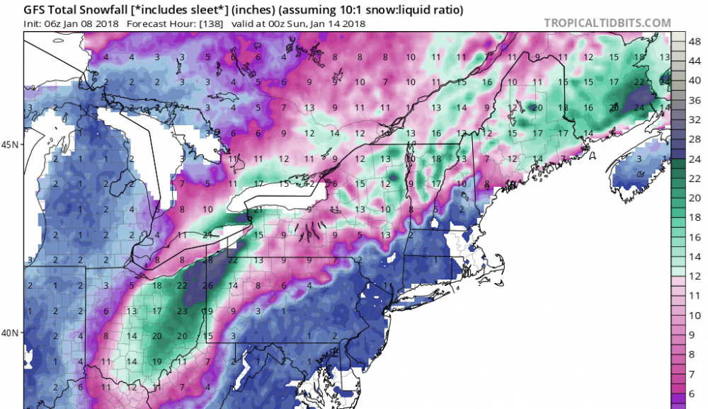
We've seen our share of ridiculous clown maps but this one is a gem. It will be fun to revisit this at the end of the week.
-
The signal is definitely there. Just need to get within 48 hours or so before confidence builds. Hopefully this doesn't slide to the SE of here.
-
CLE calling for 2-5" tonight in the higher elevations. We'll torch for a few days... Wonder how much/if any of the snow will be left by Friday. There's a decent snow pack but very fluffy. Next weekend looks interesting. 5 days out but nice to see storm potential.
-
About the same total here. I noticed that the snow seemed to pick-up a bit as you get east of 306. Looks like the ice cover is becoming extensive.
-
That's the crazy part... the least likely place you would expect a band to set-up given the solid ice cover out that way. Hopefully we can develop an upstream connection out this way.
-
It has been snowing most of the morning in Chagrin but not adding up too much given the small flake size. You can see a lot of open water on the visible satellite. Things should pick-up as the moisture from lake huron swings back west.
-
Measured 2.7" overnight. Wasn't expecting quite that much. Yeah, this area is in the bullseye on the WRF. You can already snow developing out west on the upstream connections. Hopefully there is some open water to work with.
-
Wow... just looked at 12z and the WRF is juicy on the east side. I remain a bit skeptical but as OHweather the ice is thin and likely moves around easily. With the expected strong winds a good amount of water could open up.
-
The high res models continue to show a good amount of precip from Cuyahoga on east. Might be overdone given the ice cover but things look pretty good for a few inches. CLE's snowfall map has 6-8 in this area with 8-12 in northern geauga.
-
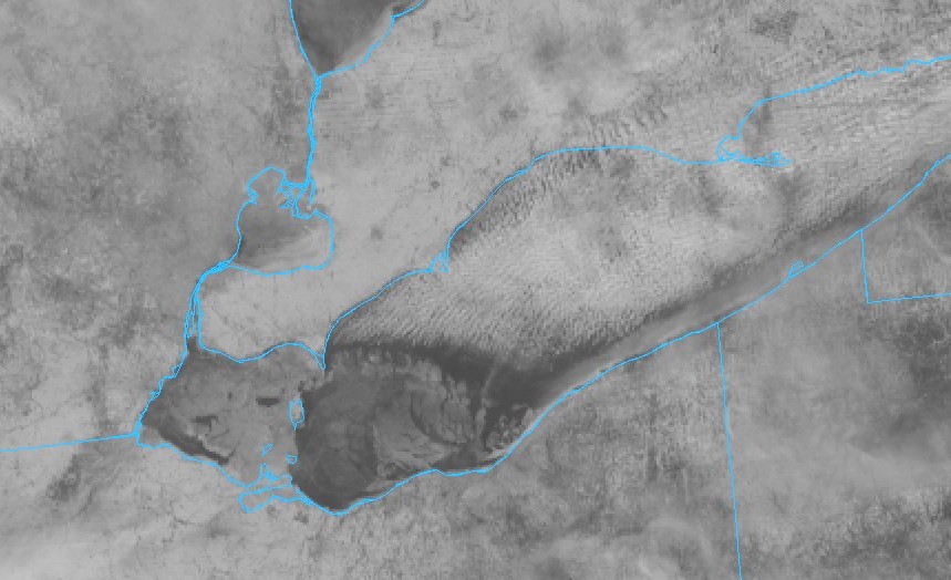
I think we will be a little too far west for lake huron moisture but I could be wrong. I'd bet we see the bands form along the edge of the ice. The strong winds have pushed the ice around quite a bit as it is still thin so there will be some moisture/heat flux. Nice view of the ice today.
-
My monthly snowfall for December was 30.3". Certainly one of the better December's in recent memory. The only thing missing was a big LES event.
-
That's a healthy band in Lake County. Winds are currently around 275 or so... Pretty far off from 290.
-
Thanks for the forecast and happy new year! Be safe out there. I’ll be sleeping by 11. This would be an ideal set up Cleveland without ice cover. Just what we have to deal with given the shallow lake.
-
290 is as good as it gets for our area... maximizes the fetch all the way to Michigan. Really a bummer that we are a few days late with getting an ideal flow. The ice will definitely hurt heat/moisture flux but it’s not solid from Lorain on east. Only problem is that 290 brings the winds directly across the ice covered areas.
-
Nice view of the ice on satellite today. From Lorain west there is ice cover, but not solid. The western basin seems to be closed off at this point. Hoping winds stay up tonight to keep the water moving around. A calm night would build a lot of ice.
-
Measured just over 7" this morning. Not your typical fluff despite the cold temps. Another chance of snow near the lakeshore tomorrow. Looks like winds are primarily from the wnw on the models unless I'm wrong. Just looked at the wrf and I don't see a wsw flow.
-
It's a winter wonderland out there. Sitting right under the Lake Huron band. Haven't been out to measure but it sure looks like double digits. Huge flake size within the band.
-
It has been pouring snow. Eyeballing another 3+ in a short amount of time. Unusual set up but this could be a good one.
-
It's ripping under the heavier returns and the radar look great to the north. The Huron fetch looks like it's making a run for the Eastside.