

NEOH
-
Posts
3,366 -
Joined
-
Last visited
Content Type
Profiles
Blogs
Forums
American Weather
Media Demo
Store
Gallery
Everything posted by NEOH
-
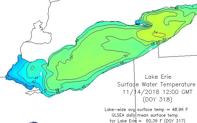
Surprised there wasn't a flare up of lake effect last night given the cold air mass and favorable wind direction. Not often you see that type of lake/air temp differential with nothing to show for it. Water temps are tanking in the western basin with 38 degrees showing up around Toledo. Still 54 on the eastern end of the lake.
-
Looks like the trough has stalled in the middle of the lake. With high pressure quickly building in its going to be tough for the band to move any further south than ashtabula county.
-
Light snow falling. Doesn't look like the bands will make it this far south. It was cold this morning with a low of 21. The bands over the lake don't to healthy at the moment.
-
Thanks for the dropping in with a forecast. I'm going to miss these this winter. For us on the southern fringes here's hoping the bands can shift a little further inland. Usually with a "weak" flow the winds have a hard time coming around to more of NW'erly direction. Winds will be rather strong so perhaps that might help. WRF's aren't too bad for 422 on north.
-
Yeah, definitely a surprise. I was up early and it was snowing hard. Given how warm the ground and pavement are I'm surprised it stuck so well. There's still snow in my parking lot but it has flipped to rain now.
-
Looks like winter out there this morning. It started snowing heavily around 6am. Grass, trees are covered... some streets have snow on them as well.
-
There's a consistent signal on about every model for accumulating snowfall this the weekend. It will interesting to see how things play out as the snowfall window looks fairly brief... but at the very least flakes will be flying. The gfs continues with the eastern track for the storm early next week. A blend of the gfs and euro would be ideal for our area.
-
Definitely not the best of weekends for fishing. Hopefully the river won't be too cloudy from the recent rains.
-
Thanks for dropping in. The cold shot does look transient over the weekend. Next week is still looking great... obviously lots of details still to be worked out.
-
Models continue to look good for the coming weekend. CLE's jumping on board the LES train... The region could see some wet snow mix with the rain as it begins Friday morning but any accumulation looks minimal to none. This storm system will shift quickly to the East Coast as a clipper system dives into the Great Lakes. This clipper crosses the region early on Saturday and will help to enhance any lake effect that has developed. Much colder air will arrive in the wake of the clipper with a change over to all snow for the snowbelt by early Saturday morning. We may see the first significant accumulations of the season. Another clipper type storm system may cross the lakes on Sunday. So stay tuned as we update the forecast through the week.
-
Seems like the trees turned and fell in a week. About 75% of the leaves are down in my yard. Going to be a long clean up with all of the rain we’ve had. Next week is starting to look interesting on the models.
-
CLE finished +1.5 for October. Hard to believe after the huge positive departures the first 10 days of the month.
-
Yeah. It looks pretty ugly. What an incredibly wet year. Too bad we are bleeding so much warmth from the lake.
-
My yard is about at the point where I won't be able to cut it because it is so wet. Finally getting some better leaf color... but overall a pretty bland fall for leaf color. Tuesday/Wednesday looks like another soaker as well.
-
Anyone else had enough of the rain yet?! Hopefully we can get a set-up like this when it is colder. Nice lake effect rain band hitting the east side.
-
I’ve had several rounds of storms with hail today. The winds were intense earlier this evening. Freezing levels are very low... I wouldn’t rule out snow late tonight. Extremely variable weather today.
-
The band today is a classic example of how localized lake effect can be. Not doing anything at my office on East Washington. Went home (about a mile east of 306 on Bell) and it was pouring with graupel mixed in.
-
Definitely a good opportunity for our 1st LES of the season. CLE is onboard... if temps are that cold I wouldn't rule out accumulations. I think 850 temps were similar during the October 2013 LES snow which caused a lot of tree damage locally. 850 mb temperatures are progged to drop to between - 6 and -8 C across the area over the weekend supporting instability over the lake. Unfortunately, this means lake effect rain showers and even potential for some snow showers in the traditional primary snowbelt will develop in the wake of the cold front. Any accumulations will take place in the higher elevations at this time.
-
CLE has had their share of bad forecasts lately. With the heavy rain approaching today's forecast looks no different. .NEAR TERM /THROUGH SATURDAY/... Warm front continues it slow move northward. The showers north of it are struggling to move to the north and east as it encounters some drier air. Still think much of NW Ohio will see some light rain through the morning but it will decrease in coverage through the afternoon.
-
Surprised the water temp departure isn't higher like some of the other lakes. No complaints about the warm weather... let's hold as much warmth as possible in the water until November. I've noticed a lot more color showing over the past few days. The leaf wilting seems to have stopped so hopefully we'll have good fall color. The one thing I have noticed this year is all of the squirrels. When we moved here 6 years ago we rarely saw any squirrels... thanks to the hawks. Now they seem to be everywhere this year - black, gray and brown.
-
The leaves seem to be wilting and falling off. They have black patches as well. It has been really humid so maybe that has something to do with it. Color should start popping in the next couple of weeks.
-
2.75" of rain since Monday. The ground was pretty dry so we needed some rain, but not that much. Leaves are falling but very little color.
-
2.6" storm total IMBY. Didn't see any flooding locally as we never really had heavy rainfall rates... Just constant light to moderate rain.
-
Only .25" at my house yesterday. The heaviest storms stayed just north and west. That's a huge difference over a short distance. I have family in Russell and they have had over 2.5" the past two days. My dewpoint was up to 79 as well yesterday evening... that doesn't happen very often. The lake breeze appears a little weaker today so we'll see what happens.
-
It was interesting to watch the storms fire on the boundaries. I'm about 5 miles east of Chagrin Falls, and had impressive cloud to ground lightning around 3pm, but little rain. Picked up .40" with the storm around 10pm. The ground is pretty dry around here so the rain is welcome. Hoping we can get a repeat today with storms firing on the lake breeze.
