NEOH
-
Posts
3,366 -
Joined
-
Last visited
Content Type
Profiles
Blogs
Forums
American Weather
Media Demo
Store
Gallery
Everything posted by NEOH
-
Only made it down to -7 IMBY last night. With the clear skies I thought temps would tank... maybe the winds kept the temps up. Looks like the snow will be a whiff to the southwest tomorrow.
-
That's really cool. Almost like that small opening is the initiation point for the entire band. Lake Erie is shut down for the time being. I'm always amazed how resilient Ontario is to ice cover.
-
Ha. I don't know how we are going to survive this 2 day cold shot?! The media has even started to ruin weather. These arctic outbreaks don't offer any benefit whatsoever. The central basin should be solid by tomorrow.
-
Hmmm... I wonder if CLE is susceptible to warm-ups? Just look at those max and mins 27 33 6 20 -8 45 0 0.03 0.7 2 14.0 33 270 M M 8 89 43 180 28 40 6 23 -5 42 0 0.14 T 2 11.8 23 160 M M 9 1 36 180 29 34 8 21 -7 44 0 0.01 0.1 T 18.7 35 250 M M 9 9 43 260
-
Temp didn't drop below freezing until after midnight. The warmth always seems to be slow to move out. That said, still a decent crusty snow pack out there with snow starting to fall. Maybe we can tack on an inch of fluff today to cover the glacier. Too bad we couldn't get a decent wind direction.
-
36/34 with rain falling. Nice to see the steadier and heavier rain right overhead . Maybe it will last just long enough to melt the pack... or what’s left of it. CLE memtioned temps fall after sunset so anytime between now and 7:45 tomorrow morning should be accurate. The next few days we can watch wny get hit with les under partly cloudy skies and bitter temps. Sorry for the rant but this winter sucks. Need a good 50-60 inches just to get to normal. With a soon to be frozen lake our chance of getting close is extremely low.
-
CLE's temp is up to 39. That area really is a sea of warmth... usually 5 - 10 degrees warmer than here. Now 34/18 IMBY. Good timing on going above freezing as the precip moves in... cold air will come in as it moves out
-
Not sure how much snow you have on the ground in Mentor but we "shouldn't" get wiped clean, at least in this area. Thankfully its not a redux of last weeks 2" of rain and 40's that wiped away the pack. Temps won't be above freezing that long. It will just make the crust underneath the powder a little crustier
-
I had a low of 1 early this morning... Hard to believe it will be raining later today with this airmass in place. Warm air never seems to have a problem moving into Ohio however. Looks like winds stay southwesterly behind the arctic front. Would have been nice to get a LES event before the lake completely freezes over. WNY is the place to be. .NEAR TERM /THROUGH TUESDAY/... Update to the update... Fixed forecast for tonight with the timing with the cold front. Slowed timing of the falling temperatures, as temperatures won`tstart crashing until after sunset. As a result, there will be a longer period of time with potential mixed precipitation/rain and have reduced snow totals for parts of the forecast area as it will be too warm for snow. CLE's long range was quite ugly as well. If the pattern change lasts a "couple of weeks" I'll be more than ready to move on to Spring. A look at the global northern hemispheric circulation is beginning to show signs that the Arctic air from the North Pole will begin to flow back toward Russia once again in a similar fashion as what occurred through December. This will aid in ejecting the cold air mass expected Tuesday and Wednesday east of the area fairly quickly. This upper level pattern change will support the possibility of stronger ridges building into North America as we head into the weekend. The North Atlantic and Arctic oscillations are indicating a change to a strong positive phase over the next couple weeks and perhaps a warming trend.
-
Yep. Same here. It would be awful to get more rain, then frigid cold early next week. Hoping that changes for the better.
-
Well, if the clipper keep trending north we'll see rain/mix on Monday to add to the frozen slush. It's not too bad here in the winter when there is snow on the ground.
-
Hard to tell how much snow was left this morning... guessing 2-3" in the deepest spots with grass poking through in the wind swept areas. Picked up an inch with the backside snow. The front really took its time coming through... temp didn't drop to freezing until after 1am. Hopefully we can build the pack back up with clipper snow.
-
We'll see. The combo of temps in the 40's, dews in the upper 30's, strong southerly winds and 1.5" of rain is tough on the snow. I don't think the front comes through until late tonight so a lot of melting yet to come.
-
Heavy rain is just training along the central lakeshore counties. CLE may need to rethink their AFD... Deep moisture continues to feed into the region ahead of low pressure approaching Chicago. Models have trended upwards with respect to QPF with several solutions indicating portions of NW Ohio could receive 1.00-1.25" today. The 00Z/GFS is a high outlier with as much as 1.75 inches forecast across NW Ohio. So far upstream observations in Illinois and Indiana are in the 0.75-1.25 range and feel the GFS is too high. 06Z GFS has also trended back down below 1.25 inch which is a good trend to see. Forecast axis of highest QPF extends across the north, with an inch or more also expected in NW PA. This obviously raises flooding concerns with many areas holding around an inch of water in the snowpack which will begin to slowly melt as temps/dewpoints continue to climb today. The most immediate concern is blocked drains, especially in urban areas where snow is piled up. Some of the rain will actually be absorbed and stored in the remaining snowpack so not expecting to see a full release into area waterways. We will also see rises developing on area rivers but that will be slower with no flooding expected until at least tonight. A Flood Watch or Areal Flood Advisories may still end up being needed today to account for considerable ponding. Much of the run-off may be somewhat delayed in reaching area waterways as it accumulates initially in the large snowpack which will not all melt today for most areas.
-
Its pouring out there with a lot more rain on the way. Sucks to be in the jackpot zone for rain. I bet the snow is pretty much wiped clean by the end of the day. It would have survived the mild temps and some rain, but an inch+ of rain and strong winds isn't good. The LES potential isn't looking good for this area. Winds are much too westerly for any area south of Rt. 6.
-
Hard to believe we are going to go from bitterly cold temps to rain tomorrow. The snow is deep so hopefully some of it survives. Looks like a .5"+ of rain so it will be ugly. I guess the only positive is that the thin ice on the lake should melt some. Looked at the visible satellite yesterday and the western basin was covered along with shoreline areas in the central basin.
-
It didn't last long but rates were outstanding. Definitely the heaviest rates of the season. Nice way to end the weekend.
-
I’m east of those bands. Looking forward to them shifting into Geauga county. No doubt they are strong.
-
What a great storm. Going with 10-12" for a storm total. It's almost impossible to measure with the strong winds.
-
That's crazy. What an awful total so far... not accurate at all. CLE has always had issues with measurements. The west side has been under the heaviest returns for quite some time.
-
Could be our best storm in quite some time if these trends hold. Light/mod snow here. Should pick up considerably later this afternoon.
-
Good to hear its snowing west of here. We've been in a bit of a snowhole in Geauga county.... the ENE wind always slows the onset. Just started to snow lightly about 10 minutes ago. Sounds like it picks up quickly. CLE upped snowfall amounts everywhere.
-
12z nam and rgem bumped up precip along with the hrrr. Good sign. Better than going in the other direction. Snow should be starting soon. That dry ENE wind always slows the onset.
-
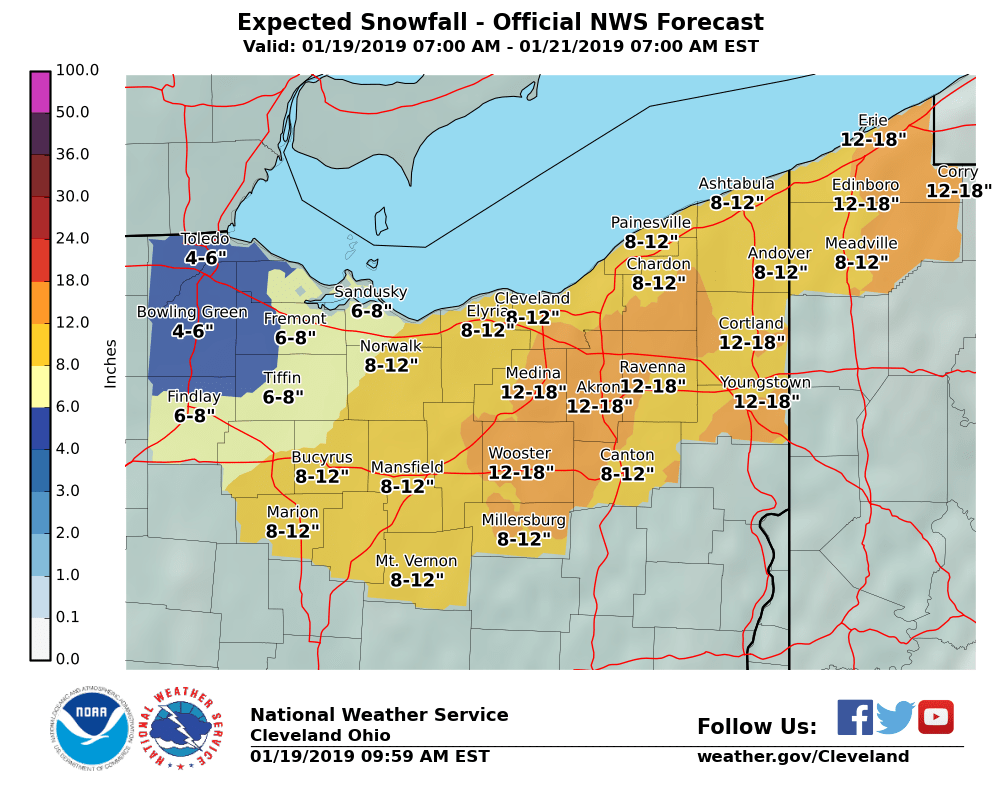
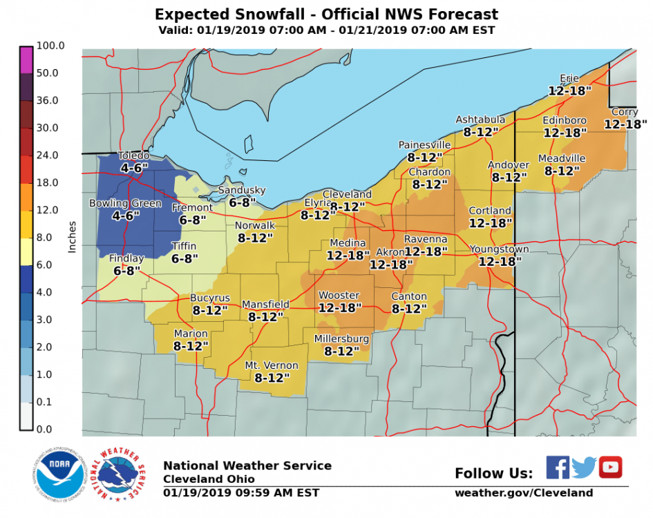
I didn't notice any dramatic shifts. Still think 6-12" is a good bet. The only concern I have at this point is all of the convection in the south stopping moisture transport north. If 6" is the basement I still won't complain given how rare it is to get a decent synoptic storm around here. The euro has been rock steady at .8" of precip... so I'm riding it.
-
That is his graphic. Do you know him? Seems very knowledgeable. His insight is really helpful to an amateur. I hope your forecast busts on the low side of course :)... but seriously, seems reasonable. Appreciate you coming back to visit us.