

NEOH
-
Posts
3,366 -
Joined
-
Last visited
Content Type
Profiles
Blogs
Forums
American Weather
Media Demo
Store
Gallery
Everything posted by NEOH
-
Woke up for an early morning flight and was surprised how much snow fell. Wasn't expecting more than a dusting. Last nights Euro was great for Ohio.
-
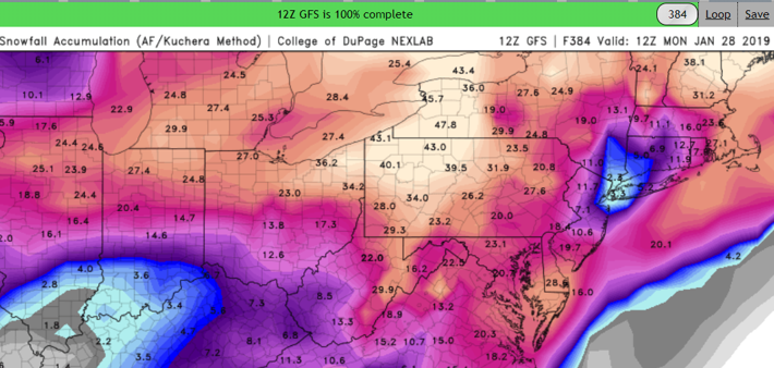
This might be one of the better clown maps I've seen from the 12z GFS.
-
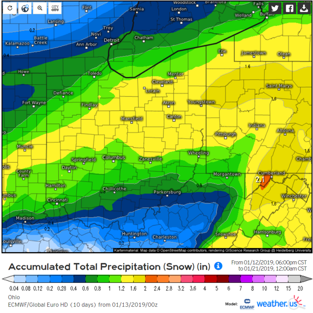
Nice storm for next weekend out in fantasy range... a good signal on the models for something tracking through the lower OV. Hope we can cash in on one or two decent synoptic storms this winter.
-
That band in Cuyahoga must be intense. We've had a few bursts here under lighter returns and it was a whiteout.
-
Nice upstream connections with bands over the secondary snowbelt and far west side. Didn't pick up much last night... around an inch or so.
-
Wind shift is pushing south across the lake. We should transition from the banded structure to the "green blob" over the higher terrain. The band earlier was very intense. We'll see what tonight brings.
-
Its supposed to pick-up later this afternoon and tonight. Definitely not as much snow here but its coming down now. Going to be tough to measure with the strong winds.
-
What a change from yesterday morning! Nice to have snow on the ground again. Yep, everything looks good at this point. Would be nice to get an upstream connection in the area. Winds stay at 290 for awhile which is a decent fetch. Once winds go NW'erly we'll probably just have that "green blob" appearance over the higher terrain instead of banding. Long duration light to mod event.
-
What a day of weather... currently under a severe t'storm warning and winter weather advisory. CLE calling for 5-9"... which seems a bit bullish. But BUF increased the totals for their area as well. With the higher winds speeds upslope locals such as ours can do well. A rare event where areas south of 322 will do better. edit: They don't normally send spotter emails before. It just hasn't snowed significantly for so long they probably assumed no one was paying attention to the weather.
-
Just received an automated email from CLE NWS - Dear Snow Spotters, Happy New Year! Some of you may have had the pleasure of waking up to 50 degrees and thunderstorms this morning with some small hail and a couple rumbles of thunder. We may even get another round of thunderstorms this evening ahead of a cold front! Then, everything changes over to snow and we will get our first lake effect snow outbreak of the season as temperatures drop into the 20s and 30s. That crazy Ohio and Pennsylvania weather... This email just serves as a notice to dig out those snow boards out and get them ready for what has already been an interesting week of weather. I think everyone will see some snow tonight and into tomorrow morning. (Perhaps only a half an inch at best for you NW Ohio folks, sorry!) Then, all eyes turn to the snow belt of NE Ohio and NW Pennsylvania for what could be 2 days full of snow.
-
Yep. The Chautauqua ridge looks to be ground zero. An upstream connection would certainly help around here. Wrf's are much better than the NAM.
-
What a nice spring... I mean mid-winter morning out there with temps in the 50's. Even has that spring smell to the air. Tomorrow will feel and look much different thankfully. Not sure what to think about the LES potential. Looks like the best moisture will stay NE of the area in W NY again. With a short fetch (300 degrees or so) we need decent moisture for appreciable snowfall. Any way it will be nice to get back to winter for a few days. And just having the grass/mud covered will be a win.
-
I was out around 5:45am and it was icy. Finally some snow to track. Pretty good wind direction for our area this week. Only question is moisture... as we've seen this season the better moisture is in W NY. A few inches of snow would certainly be a huge improvement though.
-
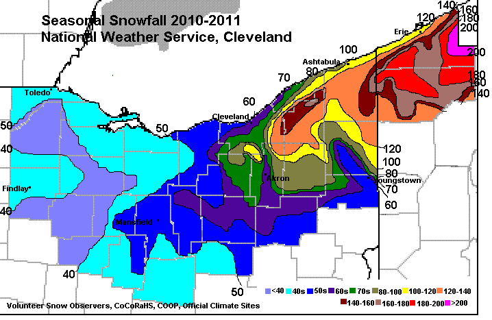
I was looking at past seasonal snowfall and wow what a winter 2010/2011 was. A widespread 120" - 160" in Geauga county. With around 140" locally. I believe that was a weak LaNina winter. You can tell by the snowfall distribution in the snowbelt that WNW/NW winds delivered much of the LES.
-
2018 was a wet year -- #4 for CLE. Temp spiked to 58 last night with high winds and heavy rain. Not the best way to ring in the new year. The long range continues to look bleak. Hopefully we start to see some changes soon.
-
The snowfall departure is starting to add up... and the long range doesn't look great at all (at least on today's model runs). Should this stretch of awful weather persist into mid-January it would take a special run to just get to normal snowfall. We rely on the lake for much of our snow so when it turns cold we won't have too many shots at LES given lake temps are already in the mid 30's.
-
No complaints here! It has been a muddy mess since the ground isn't frozen. What an awful December it has been. We'll see what January brings but the early part of the month isn't looking good.
-
Surprised to wake up to a winter wonderland. Beautiful outside. Feels like winter again. Hopefully the snow drought is over now.
-
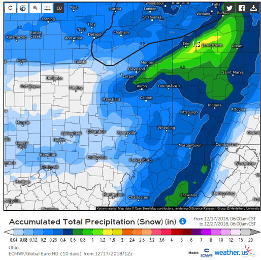
Looks like band of snow on the backside of the low will set-up east of the state line - good for PA and NY... bummer for Ohio.
-
Amazing that there's a juicy storm coming out of the south with a great track and no cold air to work with! Guessing an inch or two on the backside.
-
That's a good question. If any Winter could pull it off it may be this one. The early cold shot was enough to significantly cool the western basin to the 33-35 range. If the cold comes as forecast, it won't take long to form ice cover. So, by the time we have ideal set-ups for LES events the fetch would be very limited at least for Northeast ohio.
-
Didn't look good. Backed on the snowfall. Shame to waste such a good storm track for Ohio. Looking more and more like a nice cold rain.
-
The 12z Euro throws Northeast Ohio a bone for the weekend. It's an ideal storm track for snow around here... cold air is the big question.
-
Agreed. Looks like our snow cover stretch will come to an end today. We didn't have much but it lasted a long time. Yeah, so much for the epic storm. Hopefully we'll get our shot sometime later this Winter.
-
Temp dropped to 8 IMBY Sunday morning. Was nice to finally see some sun yesterday though. These cold overnight temps are brutal on the lake water temps. If its going to be boring I wouldn't mind some milder weather to go with it.


