

NEOH
-
Posts
3,368 -
Joined
-
Last visited
Content Type
Profiles
Blogs
Forums
American Weather
Media Demo
Store
Gallery
Everything posted by NEOH
-
Pretty big temp gradient across the area. Similar to a few weeks ago. Temps are in the mid 30's along the lake and on the westside. Still in the mid to upper 40's southeast of the lake.
-
Looks like this has the potential to be our largest synoptic storm of the year. I guess we'll know tomorrow. The warm, wet ground with marginal temps may hurt accums somewhat. I noticed that CLE mentioned cracks and openings in the ice allowing for lake enhancement the other day in the AFD. I flew into CLE yesterday afternoon and had a nice view of the lake. Outside of a few icy patches in the western basin there was no ice at all east of there -- 100% open water. I wonder if they even check the visible satellite?!
-
Kitchen sink out there this morning. Alternating between sleet, freezing rain and snow.
-
CLE issued a WWA. Mentioned the warm layer aloft as well. Looks like the 18z NAM slipped south with the heaviest precip.
-
Definitely a tricky forecast for the immediate lakeshore counties. The WRF (ARW) is onboard.
-
After the warmth this week this would certainly shock people.
-
Once mid-Feb comes around I'm ready to close the books on Winter. It is nice to have the longer daylight. The sun angle is that of late October at this point. We've had some big Spring snows but I'm about ready to move on. The pattern looks bad for snow over the next couple of weeks so I'm guessing we will finish around or slightly below normal. One big storm could swing things but you know our luck with "big" storms.
-
Temps shot up to 45 with heavy rain right now.... with temps on the low 30’s on the west side. We’ve been on the wrong side of the boundary two days in a row.
-
Temp imby all the way up to 36. The front is sitting just north as it’s in the upper 20’s by the lake. It’s going to be icy later today.
-
My expectations are very low... anything more than an inch or two would be a bonus. If anything, it will be interesting to watch things unfold. Its a messy set-up with the various waves.
-
The 12z WRF-NMM is about the best case scenario for Northern Ohio. After the 1st wave passes the boundary pushes just south of the first row of counties. RGEM and GFS show this to a degree as well.
-
Its going to be very close... but it appears we'll have a 5-6 hour period of light snow. The location of boundary will be everything. Wonder if the boundary will continue to get pushed further south following each wave.
-
Will wait until the 12z models roll in before waving the white flag. Northern Ohio will definitely be riding a fine line. Definitely a mid-Winter feel outside with snow still flying this morning.
-
CLE's afternoon disco didn't offer anything. They normally don't offer much insight so no surprise. I believe the energy gets sampled tonight so we'll see what the overnight model runs show. A shift south would be great.
-
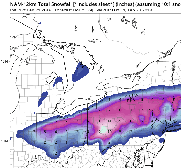
That's a bummer. Western Cuyahoga on west didn't do very well with this system. Still keeping an eye on the overrunning event. The Ukie was a huge hit for northern Ohio, but an outlier at this point. Several inches is certainly possible, with larger amounts not out of the question. CLE brought up an interesting point in the AFD yesterday - The system for Friday into Saturday still leaves much to be desired when it comes to details. A west-east baroclinic zone will set up across the lower Great Lakes for Friday. Broad lift is expected with favorably positioned jet energy developing overhead. Snow aught to break out Thursday night and continue into Friday. Any more moderate snow will likely be confined to a narrow corridor. Latest runs seem to have pushed this a bit more northward along a line from Toledo to Cleveland to Erie. Would be hesitant to push it too far north with a cold lake to overcome and in the absence of a stronger wave. So for now have a 3 to 6 inch swath across the far northern counties for Thursday night/Friday.
-
Surprised that the precip isn't filling in between the band out by Toledo and this area. I'd imagine of the lake was open the radar would look a little differently. We've had a good run of snow to start February so no complaints.
-
Definitely a sharp gradient. We've been lucky on the east side. Looks like the current low position is a bit further westy than what was modeled.
-
Snow started at 5:30am after the modeled snow hole filled. Just measured an even 3" so the rates have been impressive. This snow is so much more substantial than the fluff we've had recently. Hopefully the back edge fills in. The storm has already exceeded my expectations.
-
Just about every model has the screw hole... so much for the models not being consistent! A low in western MD on the WV border typically produces for OH. What's surprising is to see so much snow forecasted for areas NE of here in WNY. Their proximity to the low isn't any better than this area. The models have the majority of the precip to the North and Northeast of the low with very little on the backside which seems odd.
-
Thanks for the info. This is starting to feel like the hyped storm a few weeks back. I think we ended up with 2 or 3" which seems plausible once again.
-
It will be interesting to watch the evolution of tomorrow's storm. 12z NAM has a good low position for Ohio... but not much precip in the NW side. Seems like Northern Ohio is sandwiched between a precip shield to the NW and SE for a few hours before filling in. Hoping for a more expansive precip shield as I'm not sure what would cause the gap over this area.
-
Wonder if the heavier snow might go further south tonight... just looking at the radar and hrrr it would appear that way.
-
There were some heavy returns on radar near 271/480 last night. It was windy and the snow turned fluffy so perhaps I under measured. I'd gladly give up some of these smaller snows for a large one. Tough to get a big synoptic system in this pattern.
-
2.8" last night. Wasn't expecting quite that much.
-
We'll probably see a flare up as winds back more westerly. I bet ice is forming pretty rapidly on the open water with the cold temps which is probably cutting down on moisture.
