Spartman
Members-
Posts
1,204 -
Joined
-
Last visited
Content Type
Profiles
Blogs
Forums
American Weather
Media Demo
Store
Gallery
Everything posted by Spartman
-
-
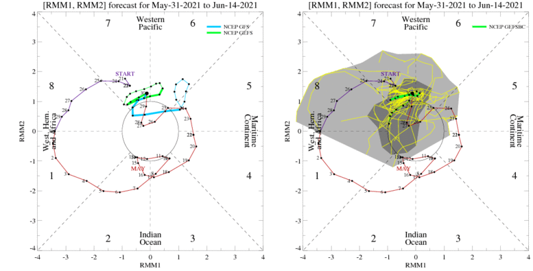
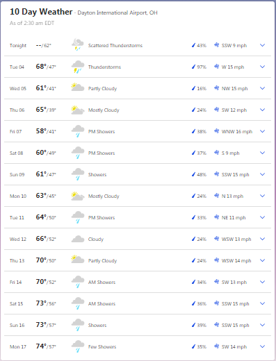
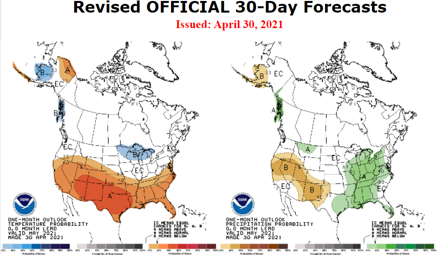
The first several days of June won't really feel like it, though. A crapfest of a start is underway with another fall-like system. To add insult to injury, TWC was hinting temps not getting out of the 60s on Wednesday while the GooFuS is hinting highs barely reaching into the lower 60s. Won't be long until NWS caves to TWC soon.
-
GFS - GooFuS
-
Joe Bastardi, if you're reading this, you got your wish.
-
Meanwhile on Saturday and Sunday, according to today's 12z GFS: Around 50 on Saturday: Around 60 on Sunday: If both Friday and Saturday are going to be overcast, may as well be the case for the entire weekend. Chilly Memorial Day weekends can be a sign of a cold summer ahead.
-
Maxed out at 88 today and yesterday. It's the highest it's going to get for at least the next few weeks.
-
Based on the radar, imagine that kind of setup happening in the Winter instead.
-
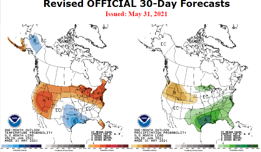
6-10 day: 8-14 day:
-
After Washout Week over this past week, only reached 48 degrees on this Mother's Day, several degrees above the record low maximum temp while CVG reached 66 degrees and CMH reached a midnight high of 51 degrees. Certainly the coldest high temperature we'll get for this month. Third overcast and rainy Mother's Day in a row. Want to bank on Mother's Day getting more worse for a 4th year in a row next year? With today's rainfall and not even reaching the middle of May yet, DAY already has 3.25" of rainfall so far this month. Hope it isn't a sign that we go for one of the top 10 wettest Mays on record.
-
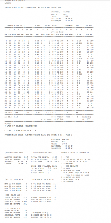
Let's say May is 100% done. Time to root for the May 2003 analog! May 2003 had a record 21 days with measurable rainfall the entire month.
-
Only topped out at 79. It's the highest temp of this month it's going to get for the foreseeable future. Let the Washout Week begin!
-
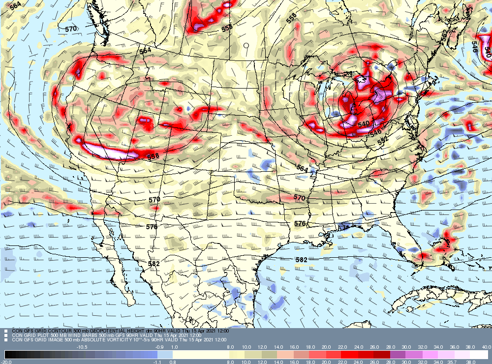
Highs in the lower 50s throughout the day. Tomorrow doesn't look better. This weekend's system is only the beginning. Models are hinting an blocking pattern developing soon. Already, another wet weekend is set to be on tap, potentially worse that this weekend. For instance, Thursday morning from the 18z GFS run: ILN: && .LONG TERM /TUESDAY THROUGH SUNDAY/... A vertically-stacked cutoff low will continue to spin north/northeast of the Ohio Valley Tuesday through Thursday while the system slowly drifts towards the northeastern US. As this occurs, surface high pressure will simultaneously try to build into the Ohio Valley from the west despite the area being on the southwestern flank of the upper-level low and possibly the far western flank of the surface low. This messy synoptic setup leaves the region in a regime with northwesterly/northerly surface winds through the middle of the work week along with sporadic chances for light rain showers and increased cloud cover when occasional, low- predictability, vorticity maximums rotate around the upper-level low. Northwesterly winds help keep temperatures near seasonal norms for the middle of April through Thursday. By Friday,the upper-level cutoff low reaches the northeast coast. This will likely result in the surface low translating to the eastern seaboard in a region more favorable for cyclogenesis. With the upper-level low and newly formed surface low off the east coast, upper level ridging may briefly build in over the Ohio Vally on Friday despite northerly surface winds persisting along with seasonal temperatures and dry conditions. Rain chances then increase for the weekend due to upper-level ridging breaking down and the possibility of an upper-level shortwave approaching. && IND: && .Long Term...(Tuesday through Sunday) Issued at 244 PM EDT Sun Apr 11 2021 A blocky and stagnant flow aloft will develop through the week...anchored by two upper level low pressure systems. The first will track slowly east across the Upper Midwest and Great Lakes Tuesday and Wednesday before slowly drifting into New England and the Canadian Maritimes by the weekend. The second lobe will develop over the Intermountain West midweek then gradually shift east towards the region by the weekend in a weakened state. Quasizonal flow will persist south of the track of these two lobes through the Ohio Valley for much of the upcoming week. The presence of a weakening surface wave over the Great Lakes in tandem with the upper level low on Tuesday and Wednesday will bring a brief shot of cooler air drawn into thew region with additional cloud cover. Forcing associated with this system will remain north of the region however with a separate surface wave tracking through the lower Tennessee Valley and keeping much of the Ohio Valley in between with drier air advecting in from the Canadian prairies. As the work week progresses...broad high pressure will only strengthen across the region with dry weather continuing. The approach of the weakening western upper low by the weekend will introduce some potential for rain showers but a poorly defined surface low and disruption to any substantial low level flow developing off the Gulf of Mexico suggest a problematic setup for more expansive rainfall over the forecast area. At this point...hard to justify much more than 20-30 pops for scattered showers and an increase in cloud cover as the upper wave drifts through the area. The strong high pressure ridge building south from Canada will keep a seasonably cool airmass across the Ohio Valley through the extended with highs largely ranging from the mid 50s to the lower 60s. Lows at night will dip into the upper 30s and lower 40s with at least some potential for patchy frost in parts of the forecast area Wednesday and Thursday nights then again by early next week. &&
-
Get ready to stick a fork on any sunshine for the entire weekend. Clouds have already thickened ahead of the weekend system.
-
-
Not even close to reaching the top 10 warmest Marches on record. This was the first March with below-normal rainfall since 2014.
-
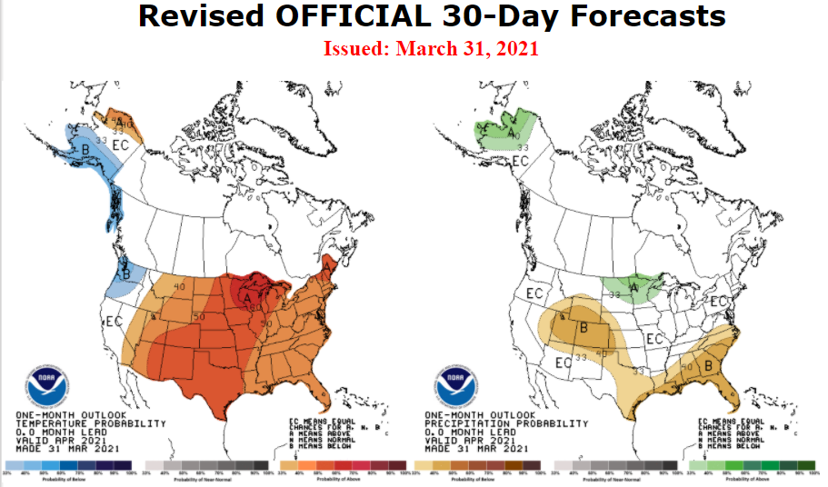
Models hinting mixed signals heading into the first days of April, especially with a very chilly start to the month. No April Fool's joke! CFS, in the meantime: The NAO, PNA, and AO heading into the first week of April:
-
Topped out at 72.
-
Approved by Joe Bastardi!
-
Got only 0.43" yesterday plus 0.07" today, ending with a 0.50" total.
-
Hit 71 here, too. First 70-degree day of the year.
-
-
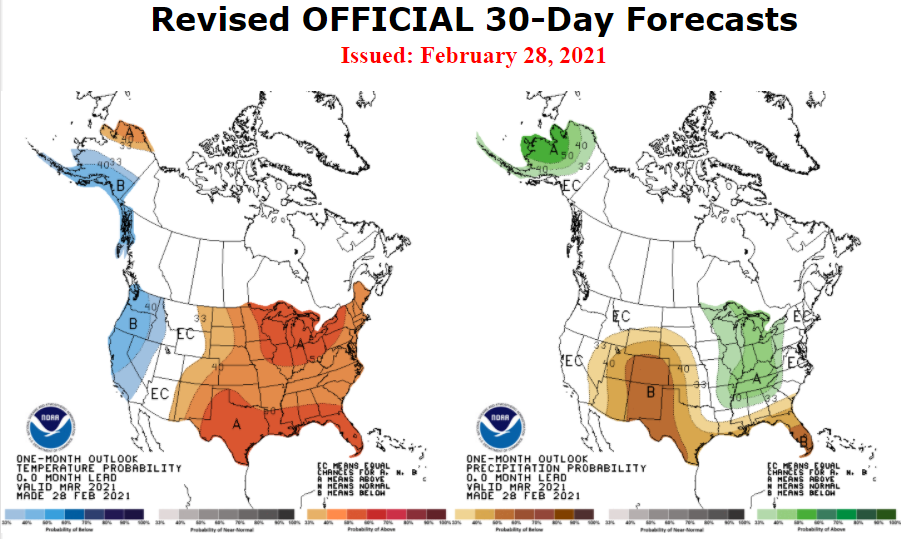
ZZZZZZZZZZZ........ Monday A slight chance of rain before 8am. Cloudy, with a high near 37. West wind 15 to 18 mph, with gusts as high as 29 mph. Chance of precipitation is 20%. Monday Night Patchy fog after 4am. Otherwise, cloudy, with a low around 32. Southwest wind 13 to 16 mph. Tuesday Patchy fog before 9am. Otherwise, cloudy, with a high near 39. West wind 11 to 16 mph. Tuesday Night Patchy fog after 1am. Otherwise, mostly cloudy, with a low around 30. South wind 7 to 10 mph. Wednesday A slight chance of rain after 11am. Patchy fog before 9am. Otherwise, mostly cloudy, with a high near 43. Chance of precipitation is 20%. Wednesday Night Mostly cloudy, with a low around 26. Thursday Partly sunny, with a high near 37. Thursday Night Partly cloudy, with a low around 21. Friday Mostly sunny, with a high near 37. Friday Night A chance of rain and snow. Mostly cloudy, with a low around 32. Chance of precipitation is 50%. Saturday A chance of rain and snow. Cloudy, with a high near 48. Chance of precipitation is 30%. Saturday Night Mostly cloudy, with a low around 36. Sunday Mostly cloudy, with a high near 47. Not to mention the narrow temperature band for the majority of especially the final week of February.
-
Sounds like they're hinting a 2011 redux.
-
Dropped down to -1 this morning, the chilliest it's going to get for this season.

