

Spartman
-
Posts
1,215 -
Joined
-
Last visited
Content Type
Profiles
Blogs
Forums
American Weather
Media Demo
Store
Gallery
Everything posted by Spartman
-
Have some suicide weather coming up over the next few days
-
-
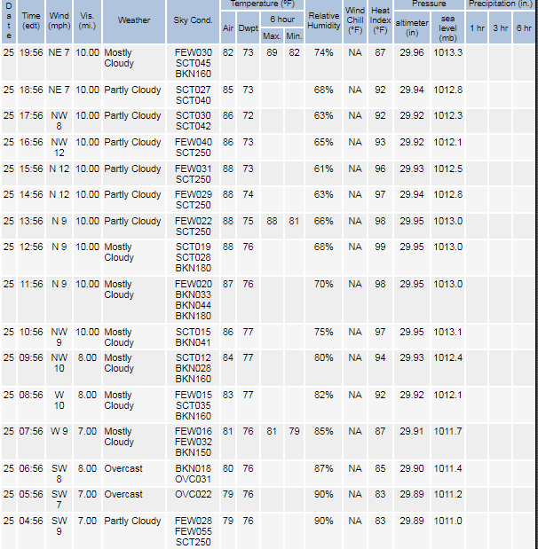
Remnants from Ophelia look to be retrograding towards our region, making tomorrow a day for suicide weather. Sun's going to hard to come by for much of this week.
-
IND AFD: .Long Term...(Saturday night through Friday) Issued at 259 PM EDT Fri Sep 22 2023 A developing tropical low pressure system just southeast of the Carolinas is forecast to move northward onshore later today. This system should then slowly slide northward along the Atlantic seaboard and slow down. As it does so, it will largely prevent systems to our west from freely advancing eastward. As such, subsidence between the two will lead to relatively quiet conditions this weekend. Surface flow will primarily be influenced by the tropical system with surface winds out of the east or northeast beginning Saturday. This should allow for some weak cold air advection leading to a reduction in high temperatures through the period. Expect highs in the mid 70s for most locations as opposed to the lower 80s we are seeing today. Less-than-ideal radiative cooling conditions may help moderate low temperatures a bit and limit morning fog potential. Clouds begin to increase late Saturday and into Sunday as a west coast trough ejects into the Plains. Most guidance stalls and eventually breaks down the trough before it reaches Indiana. However, guidance is trending in the direction of a weak cut-off low developing from the dying trough and drifting eastward. Moisture appears limited with continued east/northeasterly flow at the surface, but enough forcing may be present for some isolated showers or thundershowers. As such, slight chance PoPs are introduced from Tuesday onward. Ensemble guidance is is better agreement with the formation of the weak cut-off low than its subsequent evolution. Forecast uncertainty therefore increases late in the week. Despite differences in guidance regarding the departure of the aforementioned upper-low...enough agreement exists for increased confidence in quieter weather by Friday/next weekend. Meanwhile, the ILN AFD: .LONG TERM /SUNDAY THROUGH FRIDAY/... Complex long-term period as the combination of the low pressure (TC Ophelia) and weak upper-level disturbances to the west meander over the Ohio Valley and surrounding regions through the entire period. Zooming out and examining the longwave pattern over North America reveals a longwave ridge axis extending well north over Hudson Bay late this weekend into early next week. This is largely due to a longwave trough becoming established over the northwest CONUS and western Canada. While there are uncertainties in the exact location of the feature, ensemble guidance (WPC clusters) are fairly confident in a closed or cut-off low becoming established over the region through midweek, before eventually evolving into a more classic Rex Block pattern (Ridge to the north with low to the south) by the end of the week. Due to the general weakness of the overall pattern described above, confidence is high that the Ohio Valley region will avoid widespread hazardous weather through the period. However, it does not appear the period will be rainfall free as has been the case for much of September. After the remnants of TC Ophelia dissipates, the breakdown of the circulation allows for the below normal PWAT anomalies to be replaced by above normal values. The values are not significantly high, but it does point to a likely day-to-day weather change, especially through midweek. Conditions are expected to be more cloudy, with occasional rain shower chances across the area. Expect high temperatures to be limited into the 70s due to these conditions. The high confidence regarding the overall pattern doesn`t result in high confidence for the daily rainfall forecast. This will be largely dependent on the location of the closed/cut-off upper low that eventually organized. At this time, the best chances are for Wednesday and Thursday, with ensemble guidance in agreement of a consolidated upper low in place. Over the next few days, the evolution of the pattern will continue, with chance of rainfall fluctuating up and down throughout much of next week.
-
Currently tied for the 3rd driest September on record.
-
-
Today kicks off what may very well be a prolonged overcast stretch that would last into the weekend.
-
89'd again today. Still feel it's the highest it's going to get for this month. With the last 90 hit back on August 23rd, the 90s seem to be maxed out for the year.
-
Got 89'd on the first Saturday night of September. It's the highest it's going to get for the month. Almost all the 90s are dropped from the upcoming week. Today Sunny, with a high near 89. West wind 5 to 10 mph. Tonight Mostly clear, with a low around 67. Southwest wind 5 to 7 mph. Labor Day Sunny, with a high near 90. Calm wind becoming southwest 5 to 9 mph in the morning. Monday Night Partly cloudy, with a low around 70. Southwest wind around 6 mph becoming calm after midnight. Tuesday Mostly sunny, with a high near 89. Light south wind becoming southwest 5 to 9 mph in the morning. Tuesday Night Mostly cloudy, with a low around 69. Wednesday Mostly sunny, with a high near 87. Wednesday Night A chance of showers between 8pm and 2am. Partly cloudy, with a low around 68. Chance of precipitation is 30%. Thursday A chance of showers after 2pm. Mostly sunny, with a high near 83. Chance of precipitation is 30%. Thursday Night A chance of showers before 8pm. Partly cloudy, with a low around 60. Chance of precipitation is 30%. Friday Mostly sunny, with a high near 78. Friday Night Mostly clear, with a low around 58. Saturday Sunny, with a high near 79.
-
Summer 2023 Medium/Long Range Discussion
Spartman replied to Chicago Storm's topic in Lakes/Ohio Valley
-
-
May very well be stuck in the 60s today.
-
89'd today, even with temps in the 80s pretty much the entire day.
-
Temps have quit rising about everywhere
-
Forget about a heatwave until at least next year. Only reached 88 today. That's it on the 90s. What's happening during next weeks looks to be the final nail in the coffin for the summer. Sunday Mostly sunny, with a high near 79. Sunday Night Mostly clear, with a low around 59. Monday Sunny, with a high near 80. Monday Night Mostly clear, with a low around 60. Tuesday Mostly sunny, with a high near 80. Tuesday Night Mostly clear, with a low around 56. Wednesday Sunny, with a high near 71. Wednesday Night Mostly clear, with a low around 49. Thursday Sunny, with a high near 73.
-
Stuck at 77 as of Noon, despite clearing skies. Now I'm waiting to see when and if the Excessive Heat Warnings/Watches and Heat Advisories get cancelled soon.
-
Already got over a month's worth of rain during the 1st half of the month, we're pushing for one of the wettest Augusts ever.
-
Blocking .SHORT TERM /6 AM THIS MORNING THROUGH 6 PM FRIDAY/... While the synoptic setup remains fairly certain with a low northwest of the Ohio Valley, mesoscale uncertainty from tonight extends into tomorrow (Thursday). If the area remains dry overnight (no MCS diving in from Michigan), Thursday likely features highs reaching into the 90s along with dew points in the lower to middle 70s everywhere. This combination of temperatures and dew points would easily support the heat index reaching over 105 which reaches Excessive Heat Warning Criteria. However, if the dry forecast does not work out and a MCS dives south from Michigan overnight, the rain-cooled air and cloud cover in the wake of the MCS could limit daytime highs to near 90 in certain locations. Wet scenario probabilities increase further east of I-75. The wet scenario would still likely feature hot conditions by the afternoon with the heat index reaching up to 100 which reaches advisory level criteria. Either way, the main takeaway for Thursday is hot and humid conditions are expected during the afternoon. Whether the heat index reaches 100 (Heat Advisory) or 105 (Excessive Heat Warning), the risk for heat related illness will likely be elevated. An Excessive Heat Watch remains in place where the greatest uncertainty regarding convection is. An Excessive Heat Warning in now in place where confidence is highest regarding the heat index reaching 105 or above which is along and west of I-75. The watch will be adjusted in the future when the nature of possible convection is clearer. Expect Excessive Heat Warnings and Heat Advisories to get cancelled tomorrow.
-
2023 Short/Medium Range Severe Weather Discussion
Spartman replied to Chicago Storm's topic in Lakes/Ohio Valley
Super MCS seems silmilar to a cutoff low. -
Definitely another headfake. NWS dropped the 90s from Wednesday and Friday. Wednesday Sunny, with a high near 88. Light and variable wind becoming southwest 5 to 8 mph in the morning. Wednesday Night Partly cloudy, with a low around 74. Southwest wind 7 to 9 mph. Thursday Mostly sunny, with a high near 95. West wind 10 to 15 mph. Thursday Night A slight chance of showers and thunderstorms before 2am. Partly cloudy, with a low around 74. Chance of precipitation is 20%. Friday Mostly sunny, with a high near 89.
-
If we have not had any heatwaves so far this year, I say there's not going to be one at all this year. 00z GFS says heatwave cancel
-
And the real heatwave has been pushed back to the middle of the week.
-
12z GFS trying to lose the heat
-
GFS and NAM seem to be wanting to spin up a Fall-like system for Monday into Tuesday. On at least one of the days, some could be stuck in the 60s while some could be stuck in the 50s. GFS: NAM:
-
2023 Short/Medium Range Severe Weather Discussion
Spartman replied to Chicago Storm's topic in Lakes/Ohio Valley
Monday's looking like a repeat of this past Monday.


