Kaner88
-
Posts
312 -
Joined
-
Last visited
Content Type
Profiles
Blogs
Forums
American Weather
Media Demo
Store
Gallery
Everything posted by Kaner88
-
Big question on my mind, does the SPC push the Moderate Risk eastwards given what appears to be better clearing than model guidance expected plus these remarkable short-term models showing at least a couple rotating storms moving thru NE IL.
-
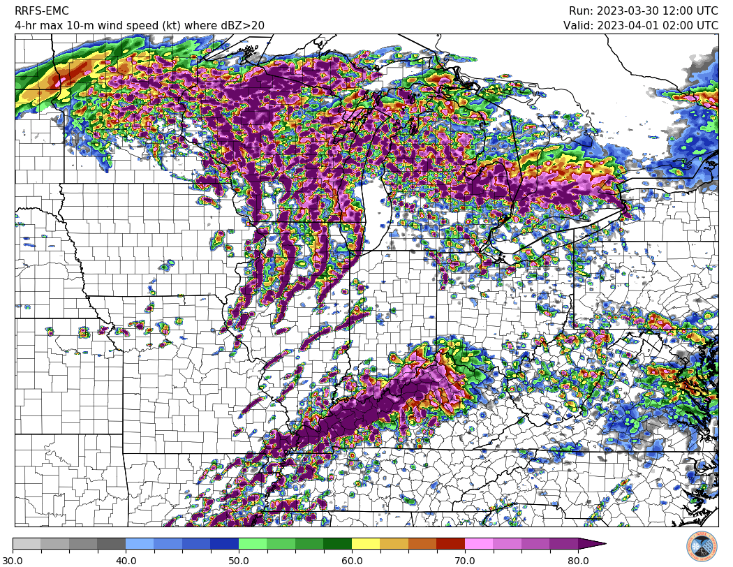
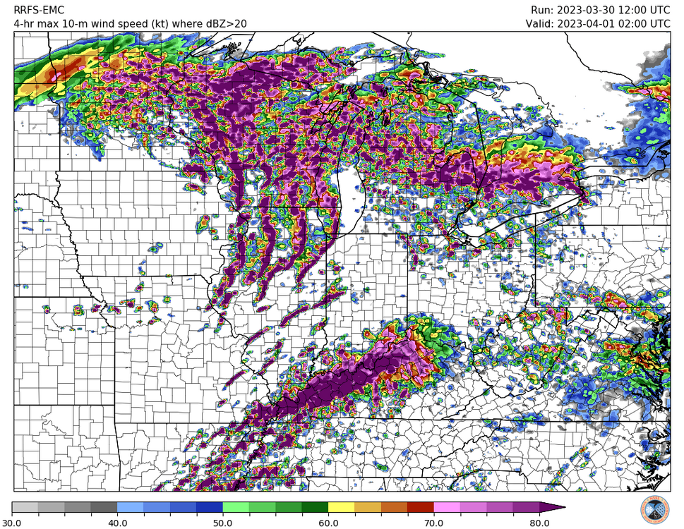
Just don't feel good about the potential for north-central / northeast Illinois. Taking models verbatim, we have potentially widespread, potentially strong storms plowing through the area in the morning hours, almost totally overcast skies through the balance of the day, and yet somehow we still end up with over 1000 j/kg CAPE? I get the very impressive dynamics of the system, including similarly-impressive unstable air advection on northwards, but a daytime high in the area somewhere in the low/mid-60s with extensive cloud cover and substantial early-morning convection never feels very good. Assuming model guidance is right and I'm dead-wrong (more likely than not), though, I'm super concerned about damaging winds in the Chicagoland area. Storm movement per LOT potentially over 60 MPH plus the aforementioned dynamics of this system lead to some eye-watering images like this ... maximum 4-hour swath 10m winds showing pretty large swaths of >80 knot (~92 MPH) winds with this line. Pretty much a worst-case scenario type of graphic, of course, but does give a sense of what mets & others here have discussed re: significant severe potential.
-

Jan 19-20: Hoosier is not allowed to start this thread
Kaner88 replied to mimillman's topic in Lakes/Ohio Valley
Actively preparing to move back to IL from here in eastern Nebraska, I get it -
Can't be upset at mood flakes this time of year, especially if this time around salt actually will work on the roads as it falls. Bring it
-
0.03" QPF in Chicago from the 0z Euro
-
Severe PTSD after the current system, I figure a starting point of 1" makes it difficult to disappoint. (though at least 2" seems believable even on drier guidance)
-
Pre-Christmas (Dec 21-23rd) Winter Storm Part 2
Kaner88 replied to Chicago Storm's topic in Lakes/Ohio Valley
Hoosier singlehandedly selling me the straws I'm grasping -
Pre-Christmas (Dec 21-23rd) Winter Storm Part 2
Kaner88 replied to Chicago Storm's topic in Lakes/Ohio Valley
Has also sped up the Arctic front slightly across Chicagoland... not looking forward to it -
Pre-Christmas (Dec 21-23rd) Winter Storm Part 2
Kaner88 replied to Chicago Storm's topic in Lakes/Ohio Valley
All we need is the 0z GFS and Euro yanking this storm west 150 miles and this thread is done for -
Pre-Christmas (Dec 21-23rd) Winter Storm Part 2
Kaner88 replied to Chicago Storm's topic in Lakes/Ohio Valley
This is giving me PTSD flashbacks to a Christmastime storm a few years back when I stayed up late into the night comparing every pixel on the SPC mesoanalysis MSLP charts to what the HRRR/RAP suite was showing as a big low moved through Indiana, to sniff out any signs the low was actually gonna be west of where models had it (giving ORD more snow). Needless to say, it did not happen. -
Pre-Christmas (Dec 21-23rd) Winter Storm Part 2
Kaner88 replied to Chicago Storm's topic in Lakes/Ohio Valley
time -
Pre-Christmas (Dec 21-23rd) Winter Storm Part 2
Kaner88 replied to Chicago Storm's topic in Lakes/Ohio Valley
Thru hour 12 -
Pre-Christmas (Dec 21-23rd) Winter Storm Part 2
Kaner88 replied to Chicago Storm's topic in Lakes/Ohio Valley
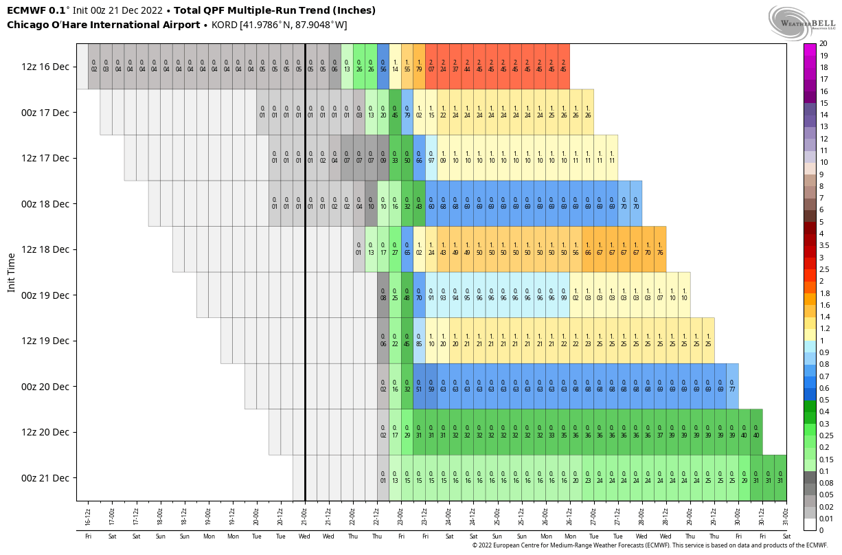
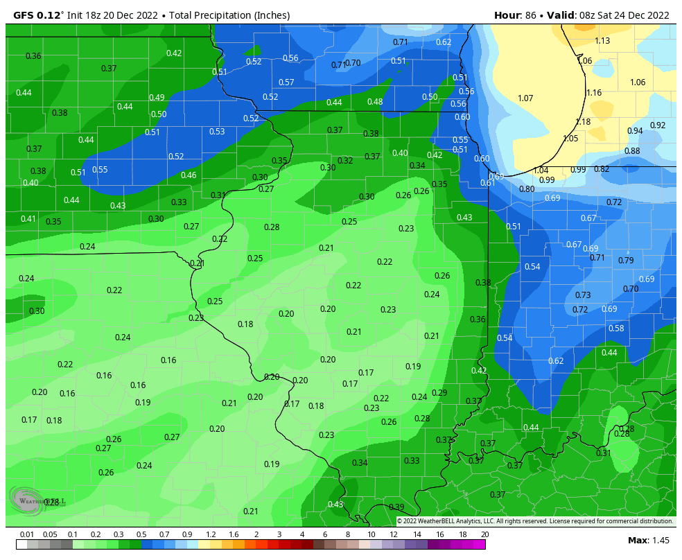
Third straight run of outright halving QPF in Chicago from last night's 0z Euro... from 1.2" to 0.15" in just 36 hours. Not a great performance by model guidance across the board with this storm.
-
Pre-Christmas (Dec 21-23rd) Winter Storm Part 2
Kaner88 replied to Chicago Storm's topic in Lakes/Ohio Valley
Question becomes, what happens if the Euro goes with the GFS? And to a smaller (but more likely) degree, what do we do if the Euro kinda ticks west to a middle zone between non-GFS 0z guidance and the GFS? Places Chicago in a tricky spot. Edit: Adding to the trickiness is the GFS ENS almost doubling downtown Chicago QPF from the 18z run to ~0.5" through Saturday AM now. -
Pre-Christmas (Dec 21-23rd) Winter Storm Part 2
Kaner88 replied to Chicago Storm's topic in Lakes/Ohio Valley
Gonna say 4" here roughly near ORD with some wicked winds & cold, can't go thru the emotional rollercoaster again like the GFS wants me to jump on -
Pre-Christmas (Dec 21-23rd) Winter Storm Part 2
Kaner88 replied to Chicago Storm's topic in Lakes/Ohio Valley
0z GFS QPF.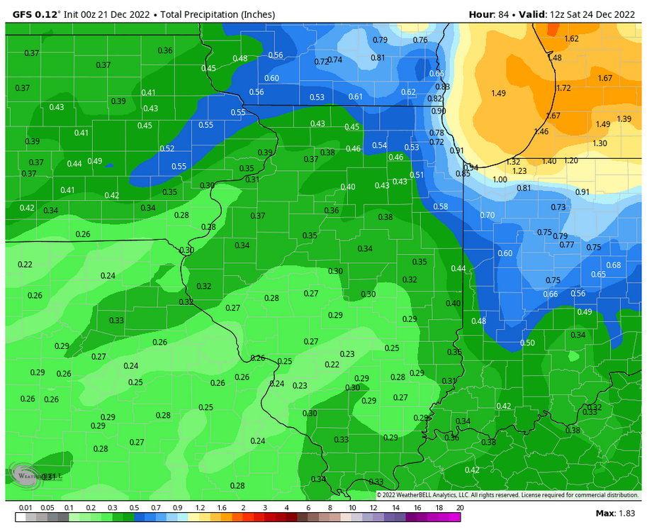
-
Pre-Christmas (Dec 21-23rd) Winter Storm Part 2
Kaner88 replied to Chicago Storm's topic in Lakes/Ohio Valley
Can't believe I'm spending my Tuesday evening comparing 500mb vorticity ribbons across Wyoming and Colorado from the 0z NAM to previous runs
-
Pre-Christmas (Dec 21-23rd) Winter Storm Part 2
Kaner88 replied to Chicago Storm's topic in Lakes/Ohio Valley
18z Euro actually a tick east after Hour 60 as the low crosses northwestern Ohio; leads to a small shaving of northern IL QPF. -
Pre-Christmas (Dec 21-23rd) Winter Storm Part 2
Kaner88 replied to Chicago Storm's topic in Lakes/Ohio Valley
Not sure what you're getting at, as RC explained in the first thread these snows are unlikely to be 10:1 but will also struggle to reach the kind of ratios that spit out higher numbers via the Kuchera method. Somewhere in the ballpark of 15:1 ratios appears appropriate for this storm. -
Pre-Christmas (Dec 21-23rd) Winter Storm Part 2
Kaner88 replied to Chicago Storm's topic in Lakes/Ohio Valley
LOT updated snow forecast range.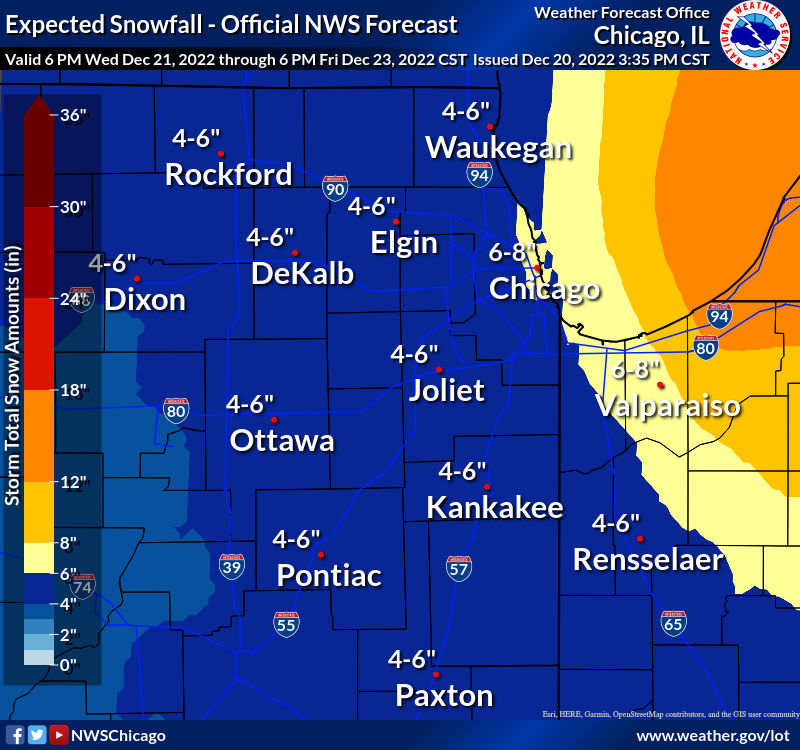
-
Pre-Christmas (Dec 21-23rd) Winter Storm Part 2
Kaner88 replied to Chicago Storm's topic in Lakes/Ohio Valley
18z GFS QPF through late Friday PM early Saturday AM... suppose you could have Chicago somewhere in a 6-8" range if we stick with a 15:1 average ratio or so
-
Pre-Christmas (Dec 21-23rd) Winter Storm Part 2
Kaner88 replied to Chicago Storm's topic in Lakes/Ohio Valley
Straw grasping in full effect, seems like the 18z GFS is showing the slightest slowing as the energy drops down through the Rockies, a modest reversal of previous trends (see attached gif).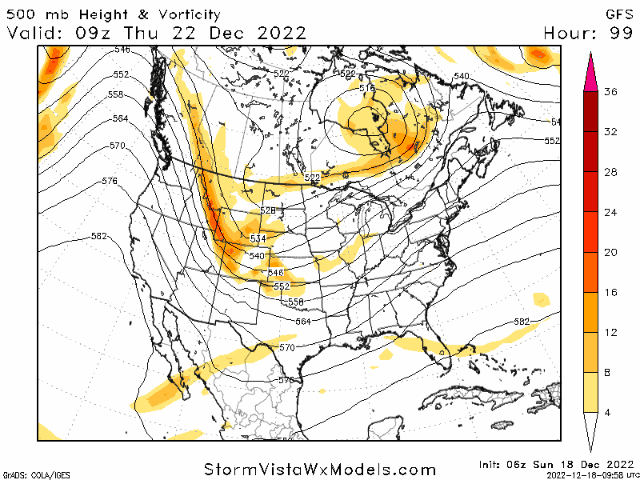
-
Pre-Christmas (Dec 21-23rd) Winter Storm Part 2
Kaner88 replied to Chicago Storm's topic in Lakes/Ohio Valley
Snippet of a detailed LOT AFD, with the smallest of bones tossed to us snow weenies in bold. Personally very impressed with the intensive messaging re: winds and cold, saying not to focus exclusively on snow when it comes to dangerous impacts. * Our storm system trended more progressive (faster movement and farther east track of strong surface low) vs. earlier forecasts, which will limit the snow amounts vs. earlier thinking, though confidence is still lower end on exact snow totals. Barring a notable change back to earlier model solutions, the snow amounts will be on the moderate side (roughly 3-7" at this vantage point), with possible exception of Porter County Indiana. This area may be close enough to be in the envelope of the heavier deformation snows on western fringe of the cyclone as well as see some modest lake enhancement contribution. Given the large swings over the past few days in the model guidance and the complexities of the setup, some shifts back to a slower and farther west surface low track (and more snow) are a lower but not zero probability scenario at this point. * For the above reason, the message continues to be a de-emphasizing of snow amounts and an overarching emphasis on the combination of falling snow, strong west-northwest winds (peaking Friday) causing blowing and drifting snow and potential blizzard conditions, and temperatures and wind chills crashing to dangerous levels that will result in dangerous to life threatening conditions for anyone who gets stranded outdoors. * We cannot stress this point enough. Do not focus on the snow amounts (which will be difficult to measure as is). The conditions later Thursday through Friday night will be more akin to what is common in the northern Plains vs. our portion of the Midwest. Any non-local travel is encouraged to be rescheduled. Forecast temperatures stay below zero through the day Friday, with wind chills on Friday bottom out at 25 to 35 below zero, which will be the the coldest conditions for most of the area since late January 2019. There is expected to be light very small Arctic-type snow or at least flurries falling late Thursday night through Friday, exacerbating blowing and drifting snow issues, particularly in open areas, with exposed north to south roadways most susceptible. Higher snow rates potentially persisting through Friday in parts of northwest Indiana (especially northeast Porter County) may increase the risk of true blizzard conditions there. -
Pre-Christmas (Dec 21-23rd) Winter Storm Part 2
Kaner88 replied to Chicago Storm's topic in Lakes/Ohio Valley
Impressive Heavy Freezing Spray Watch for Lake Michigan, usually don't see freezing spray stuff outside of Alaska in my experience.