Kaner88
-
Posts
312 -
Joined
-
Last visited
Content Type
Profiles
Blogs
Forums
American Weather
Media Demo
Store
Gallery
Everything posted by Kaner88
-

Pre-Christmas (Dec 21-23rd) Winter Storm Part 2
Kaner88 replied to Chicago Storm's topic in Lakes/Ohio Valley
It would only be fitting that this storm ends up plowing northwest again, led by the 18z ICON or something -
Pre-Christmas (Dec 21-23rd) Winter Storm
Kaner88 replied to Chicago Storm's topic in Lakes/Ohio Valley
I suppose the biggest question now is, for those more knowledgeable, is this looking like a believable final track or do more shifts appear in the cards? Between snow coming in above expectations in the Pacific NW & recent model trends favoring east shifts, feels like no one knows what's happening (or, more accurately, I have no clue what's happening). -
Pre-Christmas (Dec 21-23rd) Winter Storm
Kaner88 replied to Chicago Storm's topic in Lakes/Ohio Valley
I've got family wanting to know if they should make the drive from Nashville to Chicagoland Friday; my initial reaction was no but if we're set to get like 3" in the city, doesn't strike me as the kind of crippling blizzard set-up that was being advertised (both in terms of amounts, obviously, but also shifting the focus of winds east towards MI). This is a mess -
Pre-Christmas (Dec 21-23rd) Winter Storm
Kaner88 replied to Chicago Storm's topic in Lakes/Ohio Valley
ECMWF has now halved QPF for Chicago for two straight runs... 24 hours to go from 1.2" to 0.3" QPF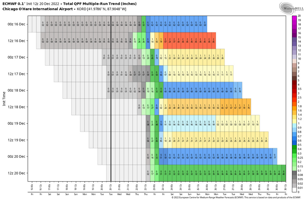
-
Pre-Christmas (Dec 21-23rd) Winter Storm
Kaner88 replied to Chicago Storm's topic in Lakes/Ohio Valley
LOT forecasted snowfall through 6 AM Friday; issued before the mess that these 12z models started bringing, but after the 0z suite.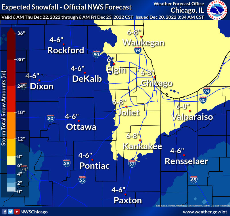
-
Pre-Christmas (Dec 21-23rd) Winter Storm
Kaner88 replied to Chicago Storm's topic in Lakes/Ohio Valley
Judging by the neighbor that is currently running their snowblower in the driveway, I'm assuming local news hasn't backed off on the blizzard stuff (at least in terms of snow totals; winds are still there, of course) quite yet -
Pre-Christmas (Dec 21-23rd) Winter Storm
Kaner88 replied to Chicago Storm's topic in Lakes/Ohio Valley
If I start out expecting 2" of snow and 50 MPH winds here at ORD, I can't possibly be disappointed ... right? -
Pre-Christmas (Dec 21-23rd) Winter Storm
Kaner88 replied to Chicago Storm's topic in Lakes/Ohio Valley
It used a special Alek sampling; Chicago will not be denied 5" on the dot -
Pre-Christmas (Dec 21-23rd) Winter Storm
Kaner88 replied to Chicago Storm's topic in Lakes/Ohio Valley
Appreciate the response. Looks to me like the change has resulted in stronger downstream ridging around the OV area, which ought to favor that further west track, does that sound about right? -
Pre-Christmas (Dec 21-23rd) Winter Storm
Kaner88 replied to Chicago Storm's topic in Lakes/Ohio Valley
Something interesting (to me, maybe not synoptically) is how recent runs of model guidance in general have been "breaking up" that broad TPV lobe in southern Canada from one big vort to what looks more like two: one in the Great Lakes vicinity, and then of course our storm system. Curious if anyone more knowledgeable believes this to be something impactful on the final track, or perhaps it's immaterial to the final track. GIF of the last few NAM runs' 500mb attached.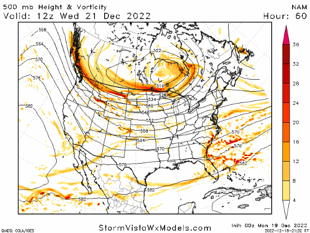
-
Pre-Christmas (Dec 21-23rd) Winter Storm
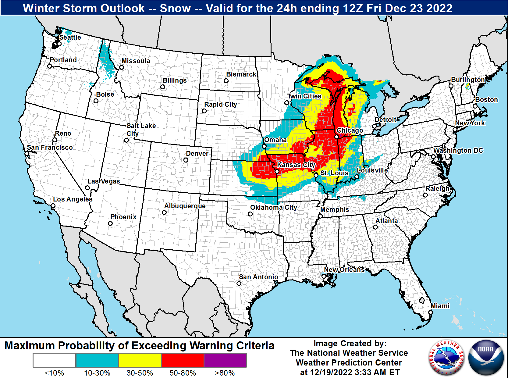
Kaner88 replied to Chicago Storm's topic in Lakes/Ohio Valley
So from what I gather, Chicago has a floor of about 3" (east jump at the last minute + typical QPF shaving as we approach event) and a ceiling of about 24" (more moisture than progged, pristine track, thundersnow, the works). Do not envy LOT right about now. Or any WFO trying to communicate about a possible blizzard right before Christmas. -
Pre-Christmas (Dec 21-23rd) Winter Storm
Kaner88 replied to Chicago Storm's topic in Lakes/Ohio Valley
For what it's worth, WPC's discussion on model guidance, updated today at 4pm Central. -
Pre-Christmas (Dec 21-23rd) Winter Storm
Kaner88 replied to Chicago Storm's topic in Lakes/Ohio Valley
One of my favorite memories from GHD I was coming down the stairs on the morning everything was winding down and looking out the backyard - the snow drifts were so widespread and so big, it looked like the all the homes were in some post-apocalyptic, Day After Tomorrow type scene, buried in snow and untouched in years. Doubt we'll get GHD 1 amounts but the winds will hopefully be enough to replicate that effect. One of the strangest sights I've ever seen in a winter storm, for sure. -
Pre-Christmas (Dec 21-23rd) Winter Storm
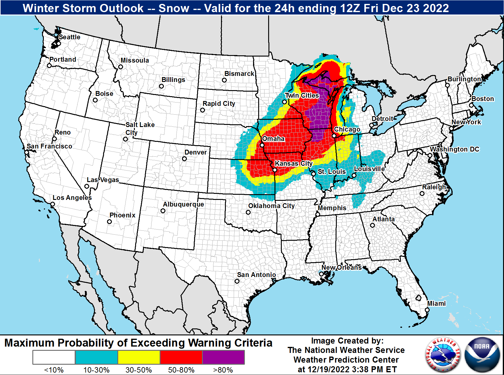
Kaner88 replied to Chicago Storm's topic in Lakes/Ohio Valley
Updated Winter Storm Outlook from the WPC, probabilities of warning-criteria snows.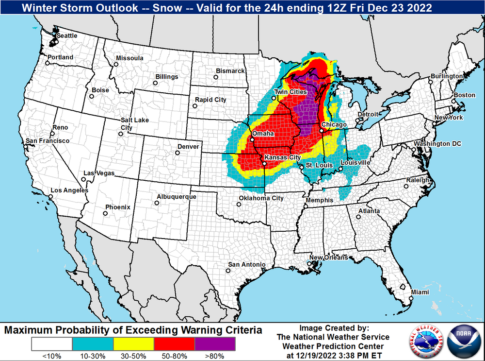
-
Pre-Christmas (Dec 21-23rd) Winter Storm
Kaner88 replied to Chicago Storm's topic in Lakes/Ohio Valley
18z NAM better show 36" somewhere or I'll be disappointed... what else is the 18z NAM good for, anyway? -
Pre-Christmas (Dec 21-23rd) Winter Storm
Kaner88 replied to Chicago Storm's topic in Lakes/Ohio Valley
10:1 Euro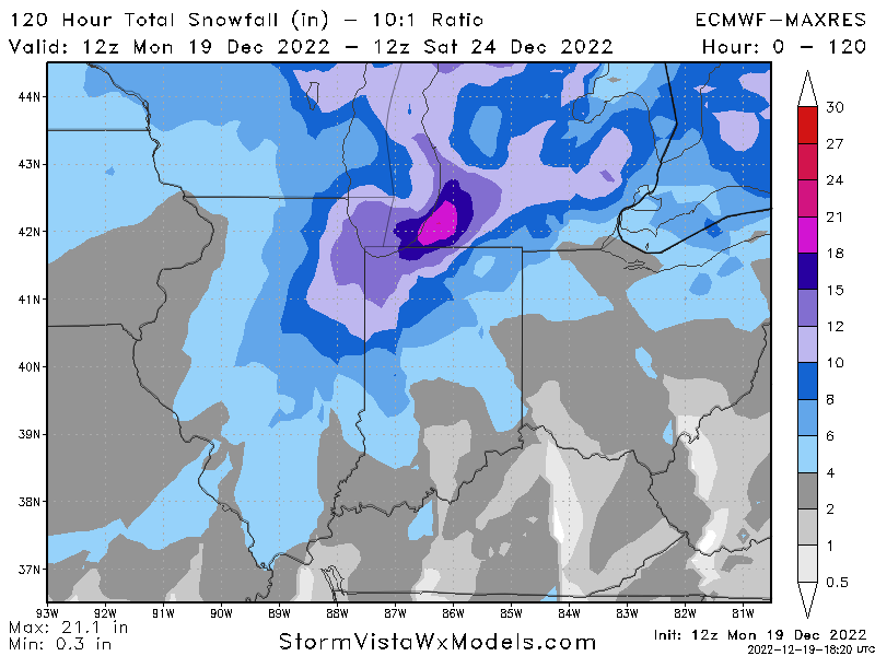
-
Pre-Christmas (Dec 21-23rd) Winter Storm
Kaner88 replied to Chicago Storm's topic in Lakes/Ohio Valley
Slightly stronger ridge along and just off the West Coast seems to be letting the storm tilt negative a bit slower than the 00z at Hour 78 or so. -
Pre-Christmas (Dec 21-23rd) Winter Storm
Kaner88 replied to Chicago Storm's topic in Lakes/Ohio Valley
GHD 1 and GHD 2 analogs got me actin' up -
Pre-Christmas (Dec 21-23rd) Winter Storm
Kaner88 replied to Chicago Storm's topic in Lakes/Ohio Valley
WPC Winter Storm Index, for those interested
-
Pre-Christmas (Dec 21-23rd) Winter Storm
Kaner88 replied to Chicago Storm's topic in Lakes/Ohio Valley
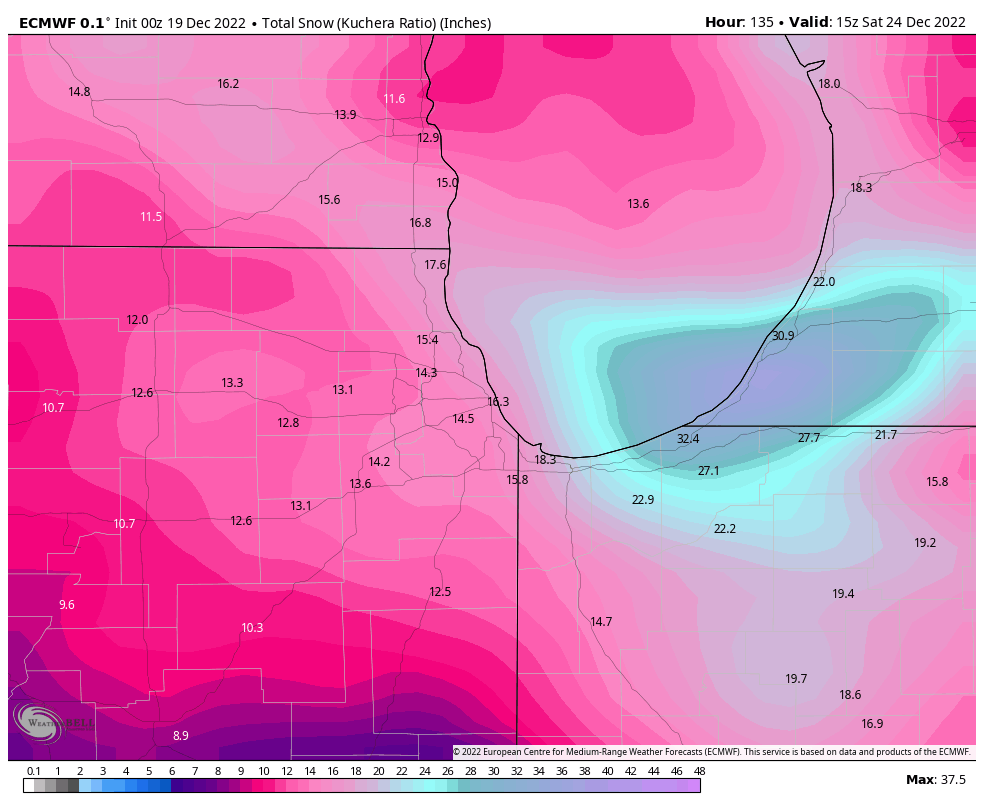
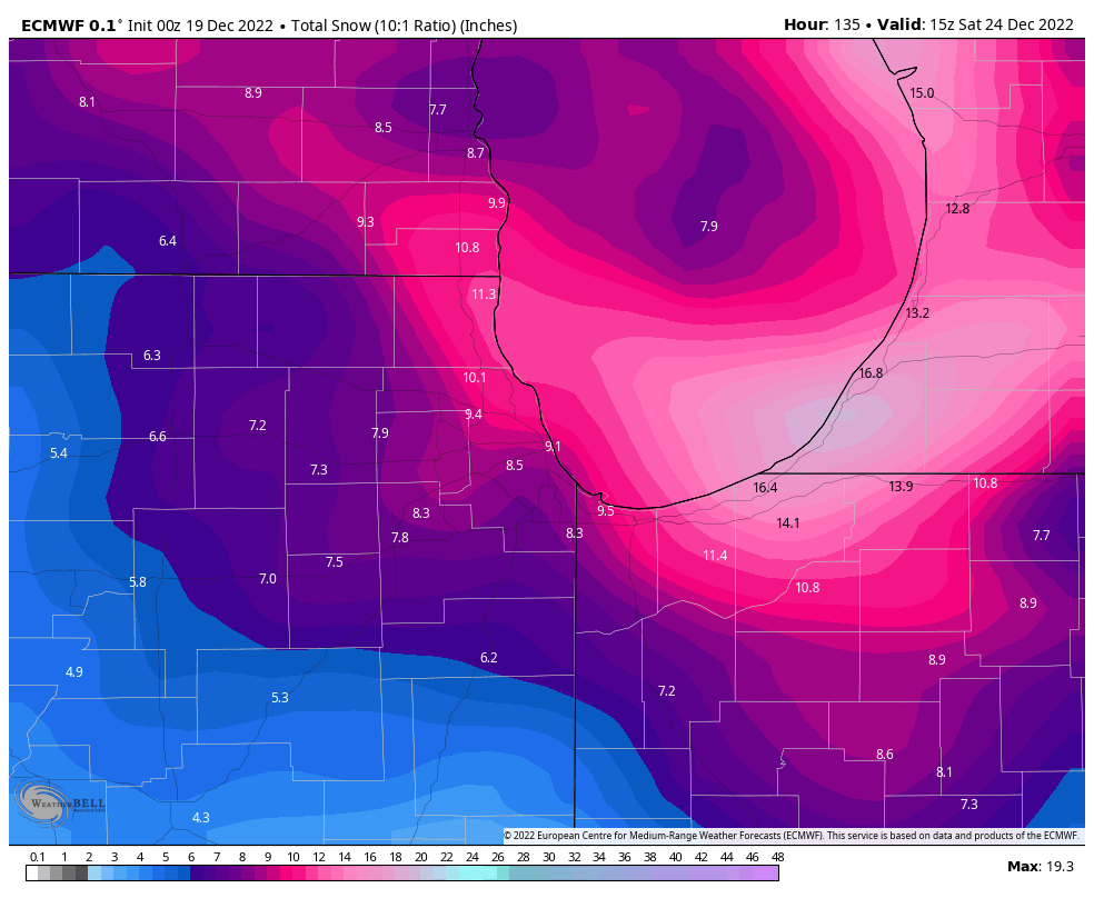
Kuchera map *and* 10:1 map for Chicagoland, fwiw

-
Pre-Christmas (Dec 21-23rd) Winter Storm
Kaner88 replied to Chicago Storm's topic in Lakes/Ohio Valley
0z Euro (10:1 ratios) thru Fri. afternoon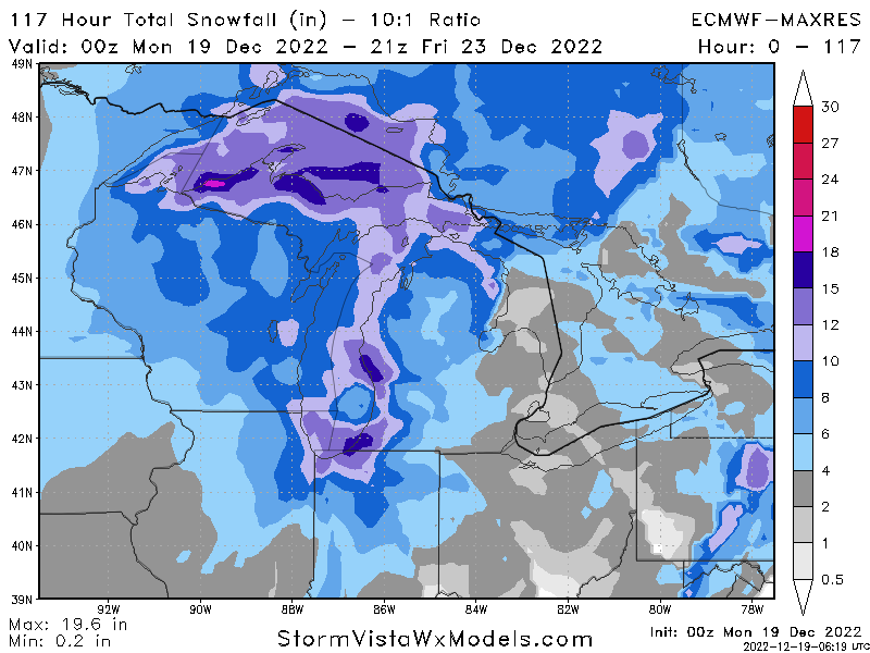
-
Pre-Christmas (Dec 21-23rd) Winter Storm
Kaner88 replied to Chicago Storm's topic in Lakes/Ohio Valley
Euro looking a little more negatively tilted by Hour 84 as the energy ejects into the Plains, which should favor a more westward solution -
Pre-Christmas (Dec 21-23rd) Winter Storm
Kaner88 replied to Chicago Storm's topic in Lakes/Ohio Valley
I've been living and dying by late-night model runs for years, looking forward to a single dataset tonight making or breaking my entire Monday, like a normal and average person -
Pre-Christmas (Dec 21-23rd) Winter Storm
Kaner88 replied to Chicago Storm's topic in Lakes/Ohio Valley
I'll go to war for member 20 -
Pre-Christmas (Dec 21-23rd) Winter Storm
Kaner88 replied to Chicago Storm's topic in Lakes/Ohio Valley
Can't get this one out of my head, given Alek's propensity for pulling wins out of his backside