

Kaner88
-
Posts
312 -
Joined
-
Last visited
Content Type
Profiles
Blogs
Forums
American Weather
Media Demo
Store
Gallery
Everything posted by Kaner88
-
Don't know if my heart can take another climb on this hellish rollercoaster
-
Despite the tough model runs, point & click numbers around the Arlington Heights, IL area have 5.7" or so. Numbers were updated earlier this hour.
-
Never a good sign when the 18z RGEM is your best friend
-
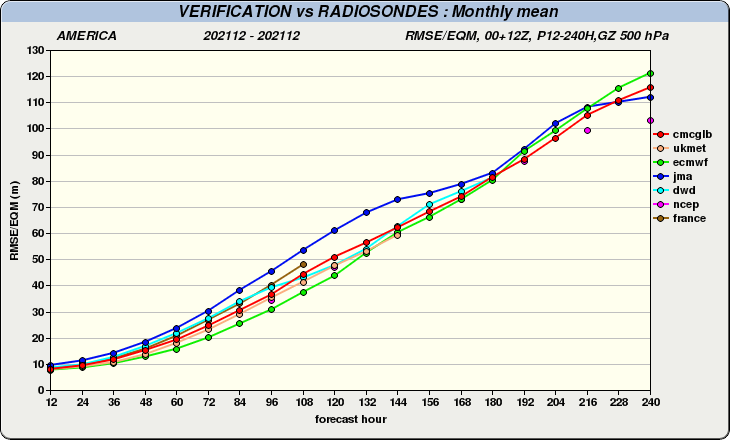
Intriguing question, and not one that's easy to answer. For the month of December, the model was a narrow third-place in RMSE through Day 5 (behind the ECMWF and GFS), though interestingly enough by Hour 144 the UKMET actually was slightly more accurate than the ECMWF. Experts in the modeling field could answer much better than myself but from the data I see, while it hasn't taken the way of the JMA (hopelessly lost), it seems it performs best beyond Day 5.
-
A Korean/ICON/GGEM consensus, though .....
-
Was worried I was the only one
-
No kidding, Hour 96 sees 1.5" QPF downtown compared to 1.06" on the 12z. Man oh man
-
One of the most detailed ones I might have ever seen. Real good stuff.
-
Fair, my bad - I suppose the main storm.
-
A question for the experienced folks here: what factors would we be looking for to materially shift the track either north or south with this heavy snow band? Of course there's the Canadian HP which would force a southerly track if it comes in stronger / northerly track if the HP is weaker ... what other flies could we find in the ointment?
-
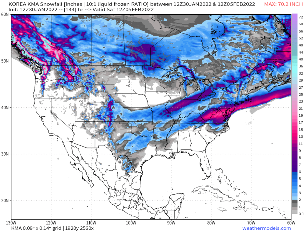
Should have added this graphic to be more clear (now to Hour 96).
-
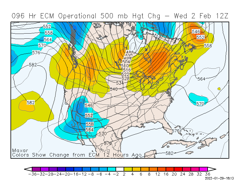
Trough out west digging deeper by hour 78, along with some modest strengthening in Great Lakes ridging (compared to 0z Euro)
-
NHC appears to be on it: 140 NOUS42 KNHC 281825 REPRPD WEATHER RECONNAISSANCE FLIGHTS CARCAH, NATIONAL HURRICANE CENTER, MIAMI, FL. 0125 PM EST FRI 28 JANUARY 2022 SUBJECT: WINTER SEASON PLAN OF THE DAY (WSPOD) VALID 29/1100Z TO 30/1100Z JANUARY 2022 WSPOD NUMBER.....21-059 II. PACIFIC REQUIREMENTS 1. FLIGHT ONE - TEAL 77 A. 30/0000Z B. AFXXX 07WSE IOP07 C. 29/1830Z D. 25 DROPS APPROXIMATELY 60 NM APART WITHIN AREA BOUNDED BY 30.0N 150.0W, 30.0N 125.0W, 50.0N 125.0W, AND 50.0N 150.0W. E. AS HIGH AS POSSIBLE/ 29/2030Z-30/0230Z Edit to add no flights planned for tomorrow
-
Gut punch here in Omaha
-
I'm curious to find out the answer to that question (how does a slower shift change the game) too - poring over the mid-levels of the last six GFS runs suggests the 'fastest' with trough ejection eastwards was either today's 00z or the 1/27 06z; 'slowest' (or, at the same time, the furthest south with the trough) was this most recent 12z followed by today's 06z.
-
I can dig it, lot better than getting 2" with that hellish north-side gradient
-
Korean model looking pretty solid though
-
Can only imagine what the DGEX would have shown with this system, RIP
-
12z ECMWF has 0.44" QPF in Omaha, falling amidst surface temps in the single digits, goodness
-

Jan 25-26th Potential Something Part 3
Kaner88 replied to Chicago Storm's topic in Lakes/Ohio Valley
Can confirm, wicked out here -
Jan 24-26th Potential Something Part 2
Kaner88 replied to Chicago Storm's topic in Lakes/Ohio Valley
Things looking good here, visibilities have been <1 mile all morning. Local office described 12pm - 7pm as best time for snow, imagine that band in Lincoln plays big into that outlook. Plows can't keep up on the main roads, much less side roads. -
Jan 24-26th Potential Something Part 2
Kaner88 replied to Chicago Storm's topic in Lakes/Ohio Valley
RIP to Chicago's anti snow weenie -
Jan 24-26th Potential Something Part 2
Kaner88 replied to Chicago Storm's topic in Lakes/Ohio Valley
RGEM lays down 10.3" in two hours in southwest Iowa, clear frontrunner for best weenie run of the year in that region -
Jan 24-26th Potential Something Part 2
Kaner88 replied to Chicago Storm's topic in Lakes/Ohio Valley
Killer gradient in Omaha on the GFS, which appears to be OAX's favored model -
If we still had the DGEX it might have had the low in Cancun


