

yotaman
-
Posts
6,311 -
Joined
-
Last visited
Content Type
Profiles
Blogs
Forums
American Weather
Media Demo
Store
Gallery
Posts posted by yotaman
-
-
Another low of 20. What a winter month we have had
-
 1
1
-
-
Low of 24. Cloudy this morning. I have only seen 2 days this month with the low above freezing. Simply amazing.
-
Had a high of 37 and the sun came out in force. Roads are mostly clear now except for heavily shaded areas. Tomorrow even warmer.
-
As predicted, clouds moved in and our low was only 17.
-
High of 30, low of 20. Picked up 5" of snow last night. Currently 22/15. Cloud cover is supposed to increase tonight and should prevent us from truly bottoming out. Single digits expected west of New Bern.
-
Sun starting to break out. Temp at 24.
-
Got about 5" here. Lots of blowing and drifting with the strong winds so hard to measure. Currently 21 with the wind chill around 5-10 degrees. Very cold out there.
-
2
-
-
22 and snowing heavily. Big time blowing and drifting already occuring. Looked out front and the trees behind the houses across the street are disappearing.
-
4
-
-
Temp at 23 and moderate snow.
-
1
-
-
1 minute ago, TSG said:
Hope I'm not explaining something well understood here... thinking this might not be common knowledge in the SE.
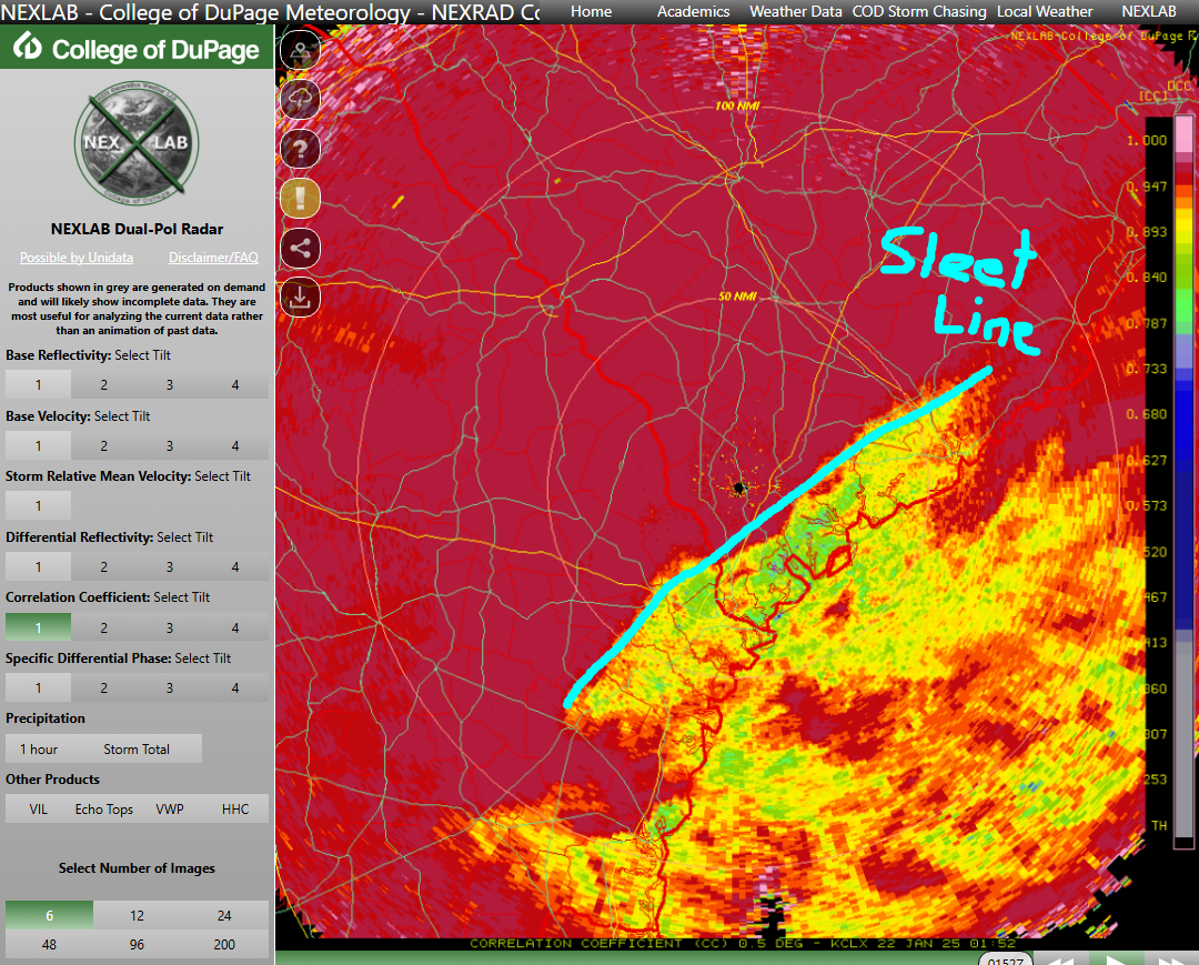
For anyone curious, you can see sleet vs snow pretty well using the correlation coefficient or diff reflectivity products. Rough sleet line outlines below for SC

That's cool.
-
2
-
-
High of only 33, low is our current temp of 23 and it's snowing at a good clip here.
-
1
-
 1
1
-
-
All snow now and roads are covered. Sticking really good. Temp down to 25.
-
4
-
-
Sleet and snow mixed. Ground starting to get covered. Temp at 26/22.
-
2
-
-
Flakes now in James City just outside of New Bern. Temp at 29/20.
-
1
-
-
1 hour ago, StantonParkHoya said:
Snowing in New Bern
Nothing in James City.
-
34 minutes ago, StantonParkHoya said:
Clouds have noticeably lowered in New Bern last 30 minutes or so
Temp has dropped too. I am down to 30.
-
1
-
-
1 hour ago, Silver Meteor said:
How the heck can New Bern get 8" with Greenville up the road only 2"? I can't imagine a gradient like that here on the coastal plain for such a short distance but of course anything's possible. When's the last time you got 8" down there?
I don't remember ever getting that much although we were close in 2010.
-
6 minutes ago, StantonParkHoya said:
New Bern looking golden
I sure hope so
-
1
-
-
31/21 with filtered sun.
-
Just now, Brick Tamland said:
12z GFS

8" for my area. I'll take it.
-
We went from 5-8 to 1-3 to less than 1 and now back up to 1-3. Hopefully the gains continue.
-
1
-
-
Wow, we have gone from 5-8 down to less than 1" in New Bern. Highs and lows have moderate too. Hope it changes tomorrow. Not looking good.
-
Yesterday we had 32 for a low and 54 for a high with .09".
Low this morning of 44, one of our warmest lows this year. Picked up .22".
-
26 minutes ago, donsutherland1 said:
With a rare widespread Gulf Coast snow event possible, some short accounts from the legendary February 1895 snowstorm are below:
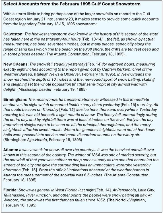
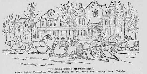
Source of the Atlanta sleighing scene: The Atlanta Constitution, February 18, 1895.
Wasn't the 1899 one even heavier and colder?
Nevermind, I just looked it up. It wasn't much snow but the extreme cold that it was known for.
-
1
-
Mid to long range discussion- 2025
in Southeastern States
Posted
Not looking forward to mine.