RIC Airport
-
Posts
2,586 -
Joined
-
Last visited
Content Type
Profiles
Blogs
Forums
American Weather
Media Demo
Store
Gallery
Everything posted by RIC Airport
-
Richmond Metro/Hampton Roads Area Discussion
RIC Airport replied to RIC Airport's topic in Mid Atlantic
I returned from Chicago last night and will be headed to NYC on Monday. Time would tell, was hoping to see snow because I haven't been there in a while in the middle of a snowstorm. I share the same sentiments because the Euro has for the most part done well this season.
-
Richmond Metro/Hampton Roads Area Discussion
RIC Airport replied to RIC Airport's topic in Mid Atlantic
EPS snowfall mean is still pretty high through that same period.
-
Richmond Metro/Hampton Roads Area Discussion
RIC Airport replied to RIC Airport's topic in Mid Atlantic
Dr. No!!
-
Richmond Metro/Hampton Roads Area Discussion
RIC Airport replied to RIC Airport's topic in Mid Atlantic
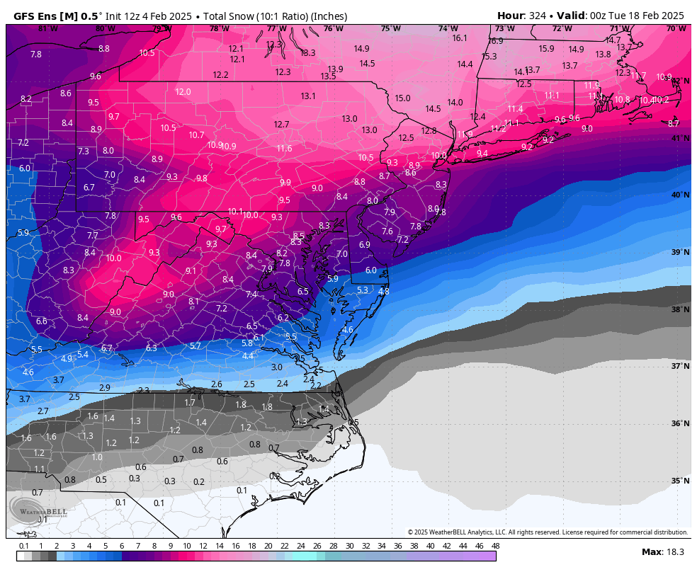
Here is the GEFS mean through that period. I am in Chicago and been busy so haven't been able to follow as closely.
-
Richmond Metro/Hampton Roads Area Discussion
RIC Airport replied to RIC Airport's topic in Mid Atlantic
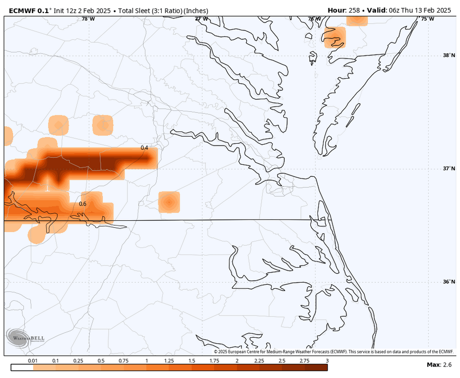
Although it was an impactful event for us, it was very disappointing that the huge totals didnt verify. RIC was 20°F during the height of the event. Meanwhile, PHF, just 60 miles SE, was close to 60°F. No wonder we mixed with such a gradient. Sleet even made it as far north as DCA and cut into their totals; although they still do exceptionally well, I think, something around 16". -
Richmond Metro/Hampton Roads Area Discussion
RIC Airport replied to RIC Airport's topic in Mid Atlantic
Agreed. And This is a very topsy turvy pattern coming, with cold and moisture coming in between warm air masses. Euro has RIC in the 70s 2 days before the storm and it warms up considerably right afterwards especially in SE VA before getting very cold again. So much can go wrong. Also, remember two Sundays ago when the cold air never arrived in time, even busted for DC. Subtle changes can make huge differences in who gets what. -
Richmond Metro/Hampton Roads Area Discussion
RIC Airport replied to RIC Airport's topic in Mid Atlantic
As with the 2003 storm, we would rely on cold air arriving and how deep it gets. And like we saw two Sundays ago, sometimes it can be slow and not arrive in time. Something to watch in future run. I'll be in NYC from the 10th to 13th so I might miss this storm unless it hits up there. I'm also headed to Chicago tomorrow and won't return until Thursday night so I won't be able to post every model run. -
Richmond Metro/Hampton Roads Area Discussion
RIC Airport replied to RIC Airport's topic in Mid Atlantic
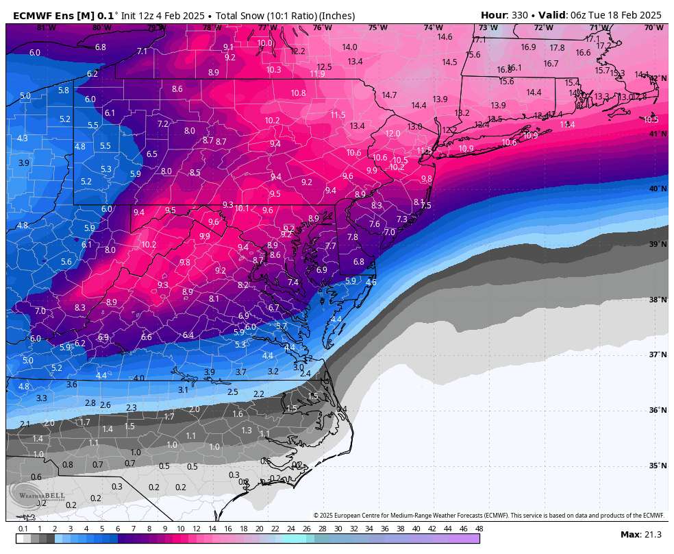
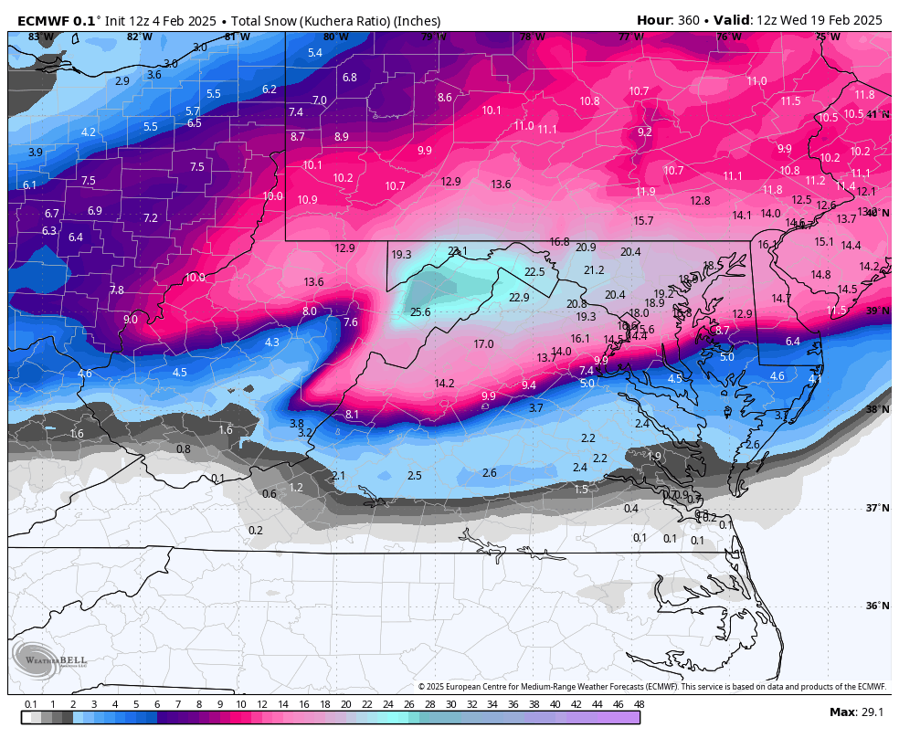
12Z Euro also has the storm for the middle of next week.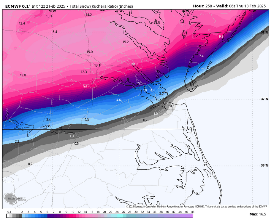

-
Richmond Metro/Hampton Roads Area Discussion
RIC Airport replied to RIC Airport's topic in Mid Atlantic
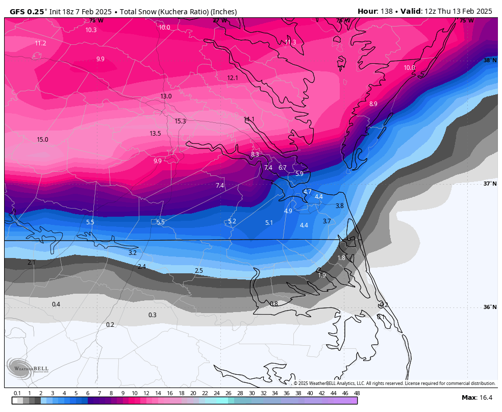
12Z GFS throwing a bone today. The setup remind me of PD II (February 14-18, 2003). That storm ended up being a letdown because what was supposed to be a 12-18" storm for metro Richmond and a sleet fest for Hampton Roads was mainly sleet for Richmond and rain for Hampton Roads. But this looks similar to forecasts leading up to that event. Obviously, we hope a carbon copy of that scenario doesn't pan out this time, and we get a snowier event.

-
Richmond Metro/Hampton Roads Area Discussion
RIC Airport replied to RIC Airport's topic in Mid Atlantic
Not sure if you've seen, but AKQ wrote about bay effect snow somewhat extensively in their recent event summer. https://www.weather.gov/akq/jan21_22_2025_winterstorm I've been getting caught up on so much. It looks like it's going to be that way at least through 2/10 or 2/15. Also, quite a few days in the mid and upper 60s, and even a few 70s are popping up from time to time on the OP runs for the end of next week. The warm temps these last few days of January will be enough to prevent RIC from finishing in the top 10 coldest January on record. -
Richmond Metro/Hampton Roads Area Discussion
RIC Airport replied to RIC Airport's topic in Mid Atlantic
https://scacis.rcc-acis.org/ Also, the below site is good for historical hourly observations. https://weatherspark.com/ -
Richmond Metro/Hampton Roads Area Discussion
RIC Airport replied to RIC Airport's topic in Mid Atlantic
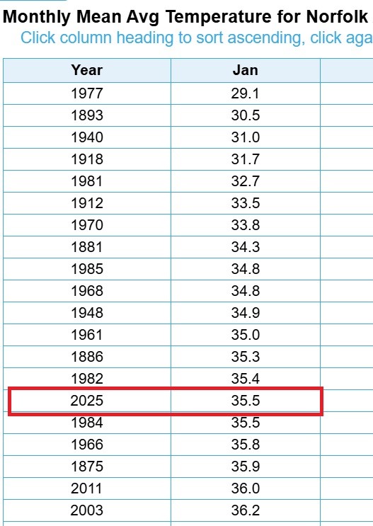
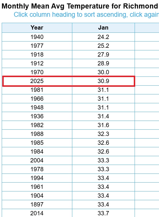
RIC hit 9°F this morning, the first time reaching the single digits since 12/24/2022. Also of note, through yesterday, January 2025 ranked as the 6th coldest on record. Although there was no extreme cold from a historical standpoint, it was just a persistent cold since the beginning of the month. There are about 8 days left, and with warmer temperatures, the current ranking will rise. Even if this month doesn't finish in the top 10 coldest, it will still be the coldest January since 2004 or possibly even 1988. Norfolk also has been experiencing its coldest January since 1985 so far and will likely end as the coldest January since 2011 or 2003.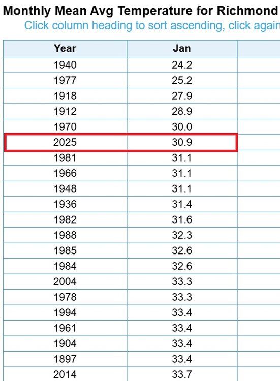
-
It probably won't matter much, but RIC is up to 6.7" after an additional 0.2" fell yesterday evening.
-
Richmond Metro/Hampton Roads Area Discussion
RIC Airport replied to RIC Airport's topic in Mid Atlantic
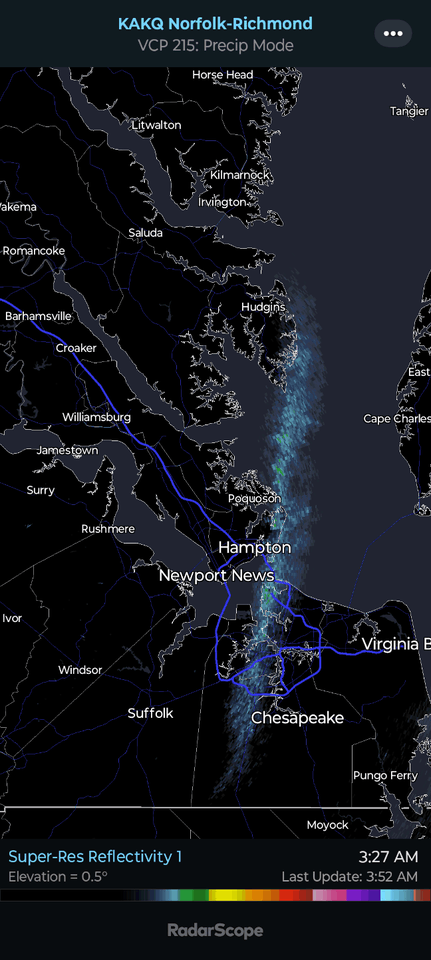
It looks like ORF finished with 3.8", and around 4" is as high as I've seen so far north of the border. There are quite a few 6-7" reports, just what I've seen across NE NC. The AKQ bot is still sending totals, and they will probably send a PNS statement later this morning when enough totals come in. https://x.com/iembot_akq Indeed, it was not a bad event. This was the fourth accumulation of snow I've had this month, which beats much of what we've seen in the last few years. Despite the blowing and drifting, I'm glad you could score with this @Stormpc and others on the southside. It was a nail biter all along on how far north this came. The GFS, albeit late, was the first model to get the western extent of the precip shield toward and then just west of Richmond, which was on par with reports. Also, the models did a great job picking up the Chesapeake Bay Effect snow streamer.
-
Richmond Metro/Hampton Roads Area Discussion
RIC Airport replied to RIC Airport's topic in Mid Atlantic
Officially 2.3" at ORF and 0.2" at RIC through midnight from this event. Should add a bit more at ORF when the next report is sent. -
Richmond Metro/Hampton Roads Area Discussion
RIC Airport replied to RIC Airport's topic in Mid Atlantic
You guys enjoy the rest of this event. We remain below freezing for highs tomorrow so we get another day to enjoy what fell. -
Richmond Metro/Hampton Roads Area Discussion
RIC Airport replied to RIC Airport's topic in Mid Atlantic
Ending here now, finished with 0.8". But certainly more than I anticipated when I woke up this morning. -
Richmond Metro/Hampton Roads Area Discussion
RIC Airport replied to RIC Airport's topic in Mid Atlantic
Still falling here in Williamsburg. I feel like it's the same intensity it's been all along. Maybe I'll finish with another tenth of an inch or two before the back edge reaches me. -
Richmond Metro/Hampton Roads Area Discussion
RIC Airport replied to RIC Airport's topic in Mid Atlantic
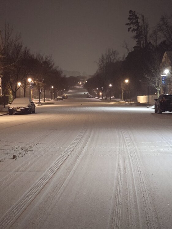
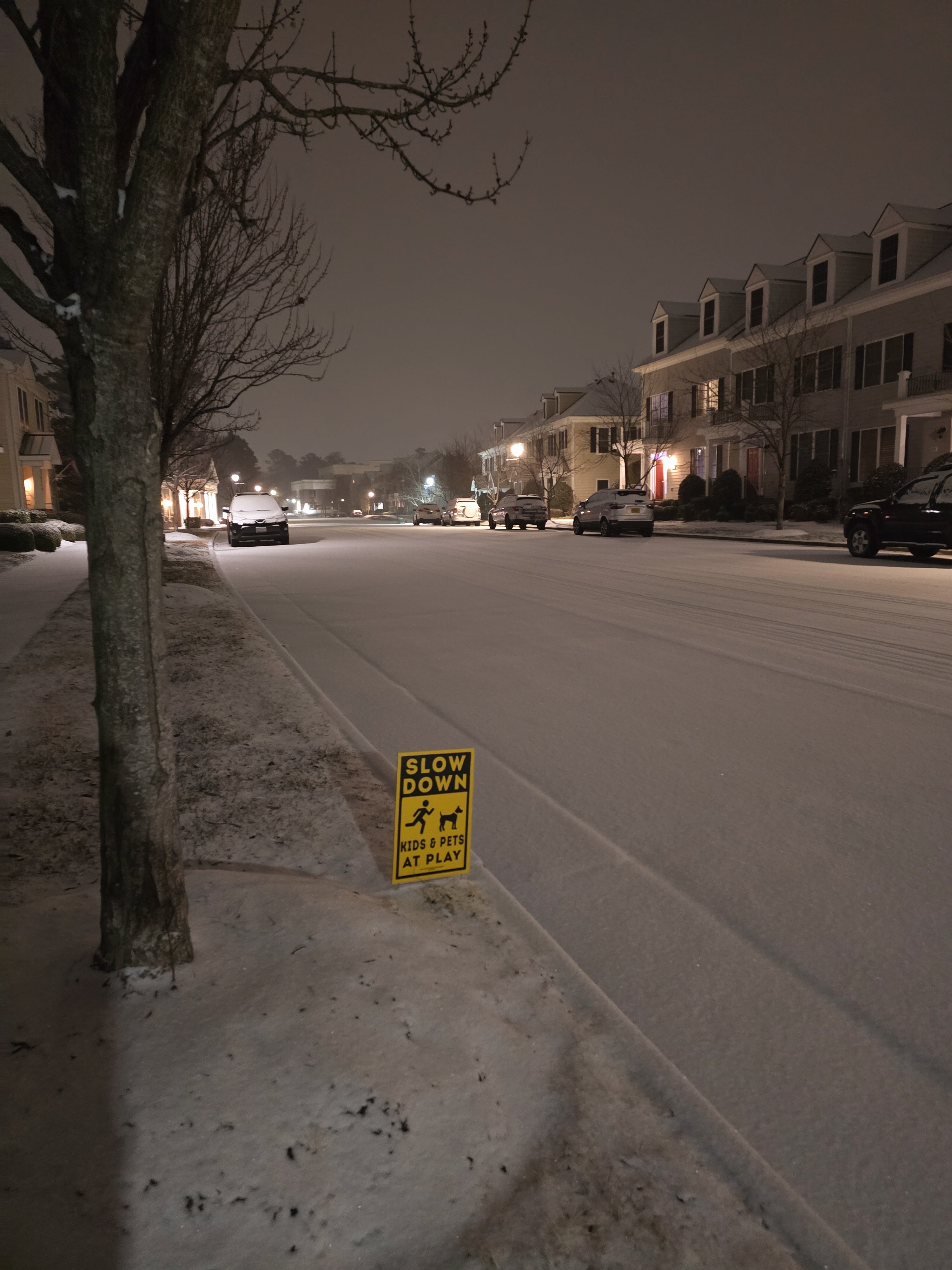
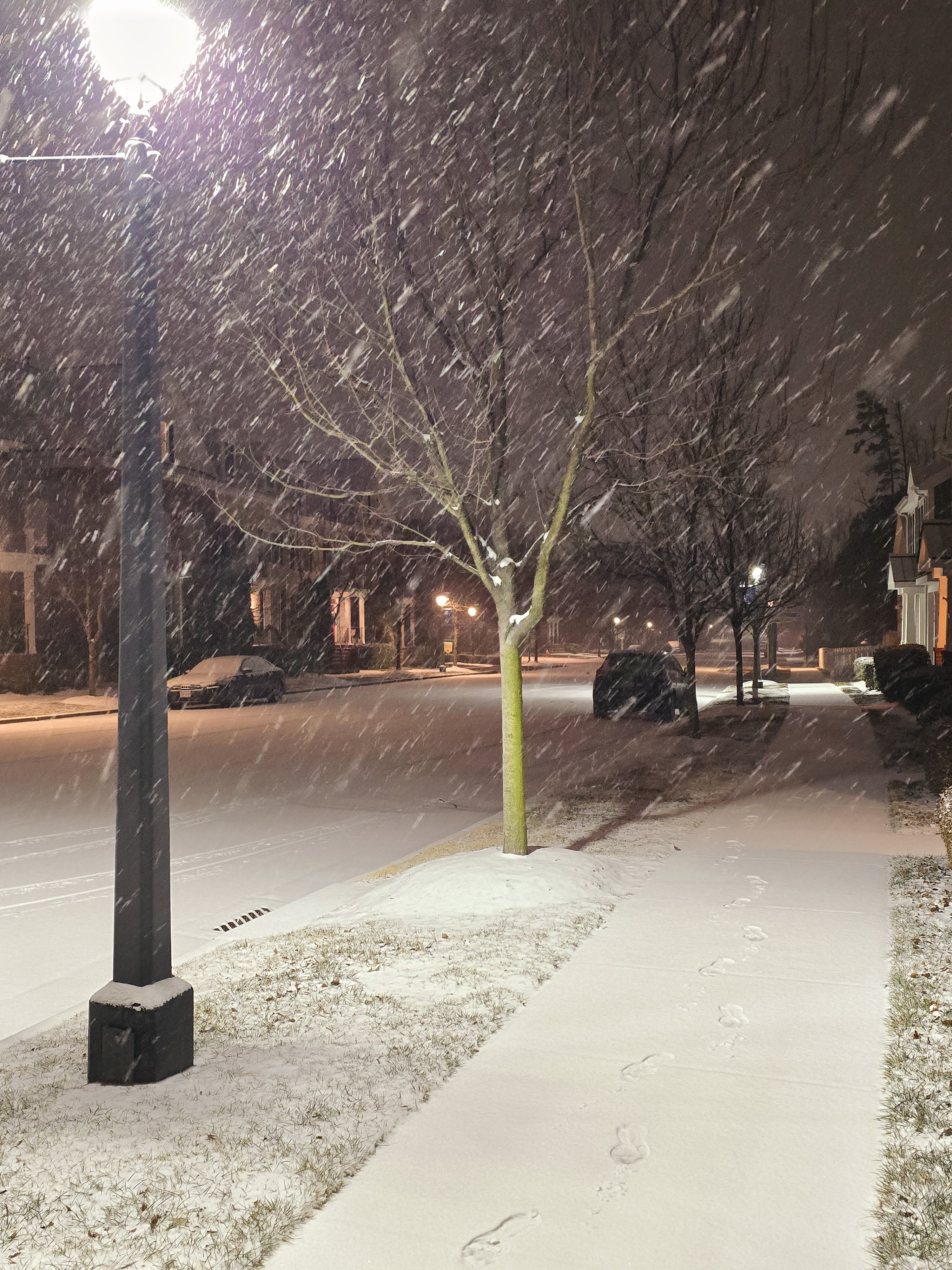
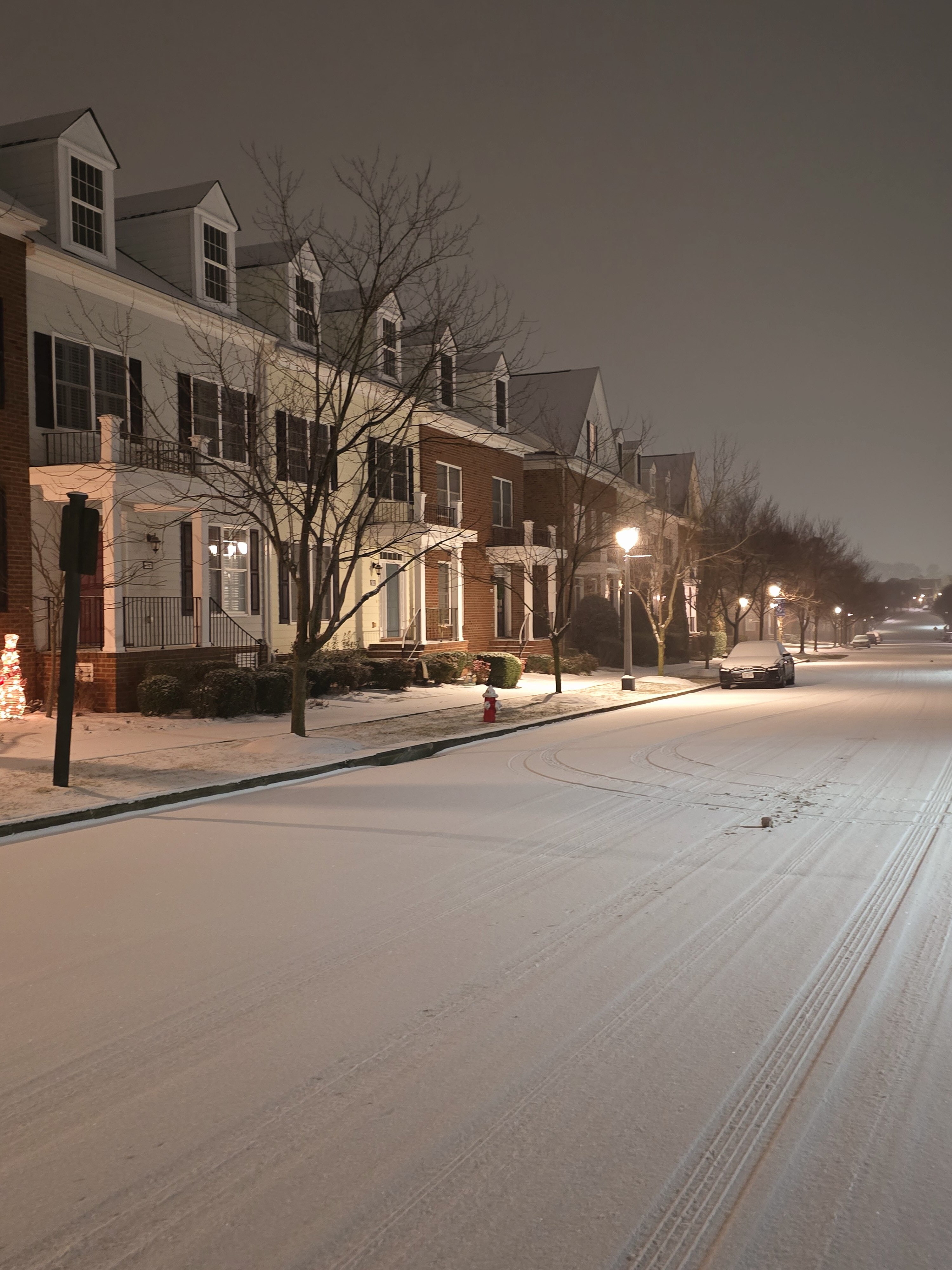
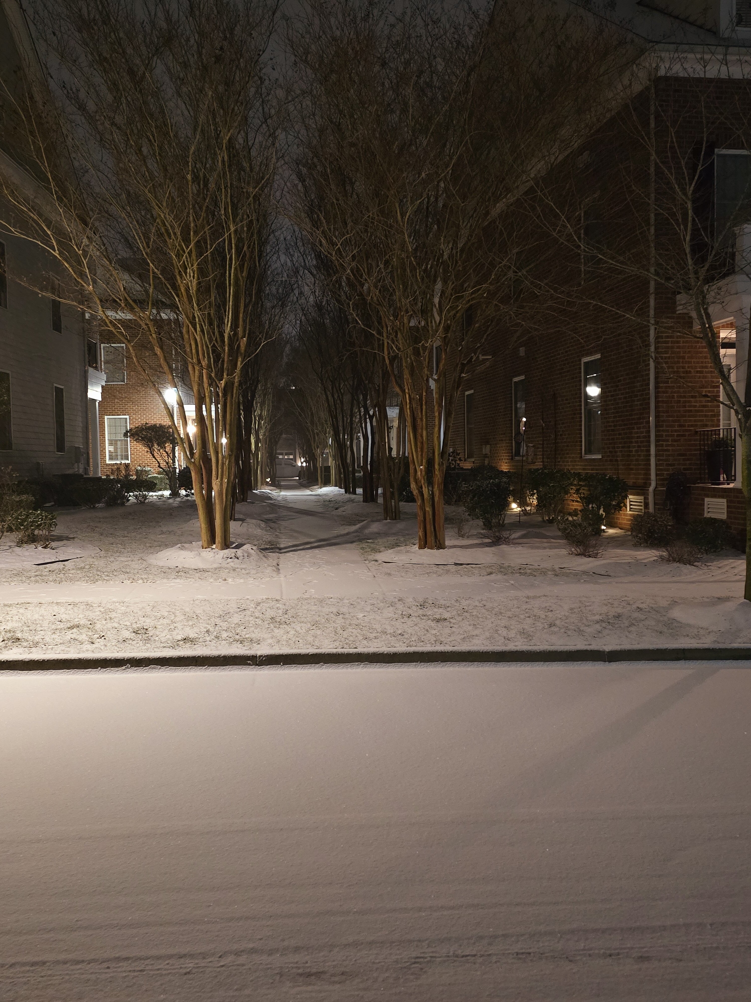
Here's a few pics from outside. I have about 0.7" two miles SW of the W&M campus. I dont think I'll reach an inch based on radar. It's a very fluffy snow and too bad I'm too far north and west of the main action. But always a beautiful site, especially at night. Seems like every accumulating event this winter has started around 7 or 8pm.


-
Richmond Metro/Hampton Roads Area Discussion
RIC Airport replied to RIC Airport's topic in Mid Atlantic
Wakefield just expanded the advisory to include Gloucester, Mathews, Greensville, Sussex, Surry, and James City Counties. Makes sense given how the roads are already covered and rapidly deteriorating with just the little snow we've had in just the last hour.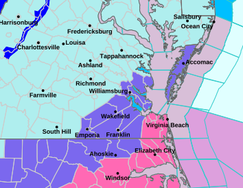
-
Richmond Metro/Hampton Roads Area Discussion
RIC Airport replied to RIC Airport's topic in Mid Atlantic
Also, going in my RIC historical archive. Snow with temps in the teens, it hasn't happened in a while.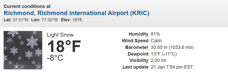
-
Richmond Metro/Hampton Roads Area Discussion
RIC Airport replied to RIC Airport's topic in Mid Atlantic
I have a solid, and I mean a solid, coating on the ground; every little flake is sticking with no melting on contact. -
Richmond Metro/Hampton Roads Area Discussion
RIC Airport replied to RIC Airport's topic in Mid Atlantic
Very light snow started in Williamsburg about 30-40 minutes ago, coating everything right away. -
Richmond Metro/Hampton Roads Area Discussion
RIC Airport replied to RIC Airport's topic in Mid Atlantic
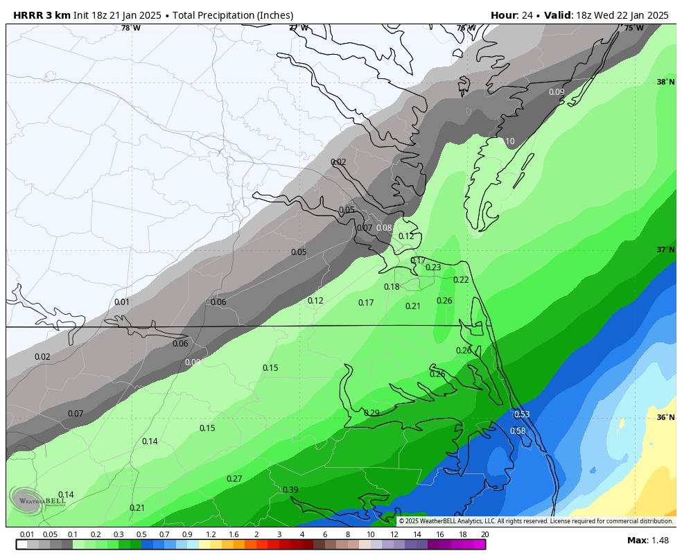
Here are the 18Z HRRR and 3K NAM runs. The 3k has been pretty aggressive. Will be interesting to see which short range model performs the best. HRRR 3K NAM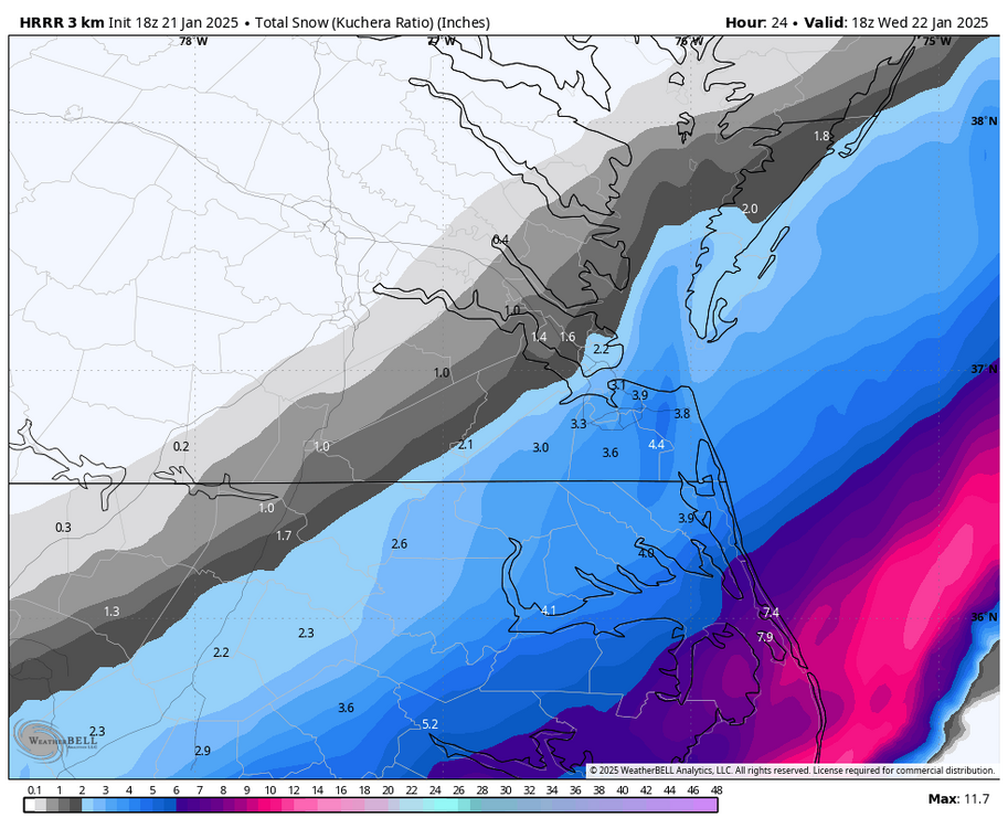
.thumb.png.023207661e9197950d2f0a071738244f.png)
.thumb.png.5ec8d57269613cb35df26abc09cd823b.png)

-
Richmond Metro/Hampton Roads Area Discussion
RIC Airport replied to RIC Airport's topic in Mid Atlantic
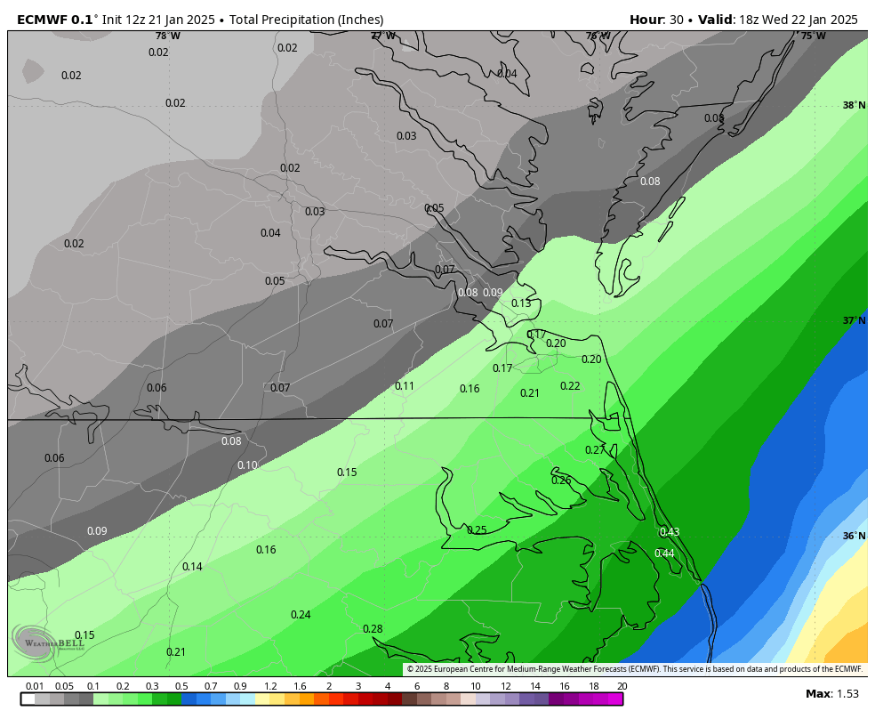
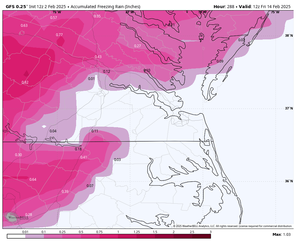
Excellent, I had a feeling they would upgrade the southside!!! Also, the latest Euro increased QPF across the region. The 6z run 0.12" for ORF, now it's up to 0.20". Yeah, I think a coating to a half inch is certainly possible, especially south and east of the city. RIC is still 21°F at noon, anything that falls later this evening will stick right away. I would be more concerned about dry air and virga the farther north and west you go.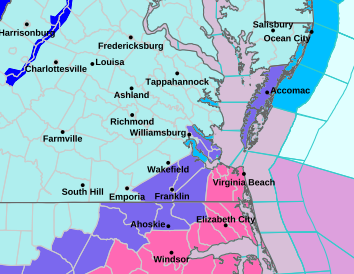


.png.a844230f1d3595998a05b28b82b9a341.png)
.png.2ce1d8f0bf2ea497091618ab4e85ec26.png)