RIC Airport
-
Posts
2,586 -
Joined
-
Last visited
Content Type
Profiles
Blogs
Forums
American Weather
Media Demo
Store
Gallery
Everything posted by RIC Airport
-
Richmond Metro/Hampton Roads Area Discussion
RIC Airport replied to RIC Airport's topic in Mid Atlantic
The late February sun angle, unfortunately, is powerful. There was less snow back in January under similar conditions that barely melted during the day. -
Richmond Metro/Hampton Roads Area Discussion
RIC Airport replied to RIC Airport's topic in Mid Atlantic
Congrats to all! This was a very fun event! Tracking snow is exhausting. I crashed last night without the stress. -
Richmond Metro/Hampton Roads Area Discussion
RIC Airport replied to RIC Airport's topic in Mid Atlantic
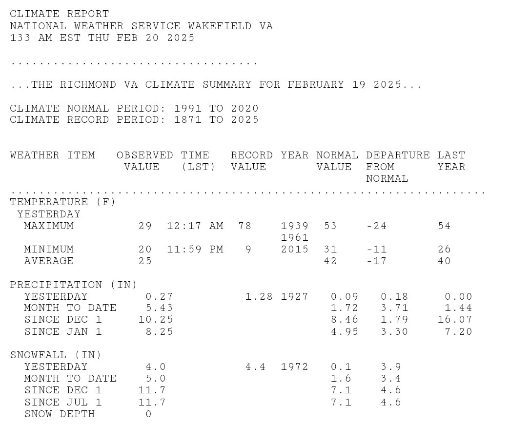
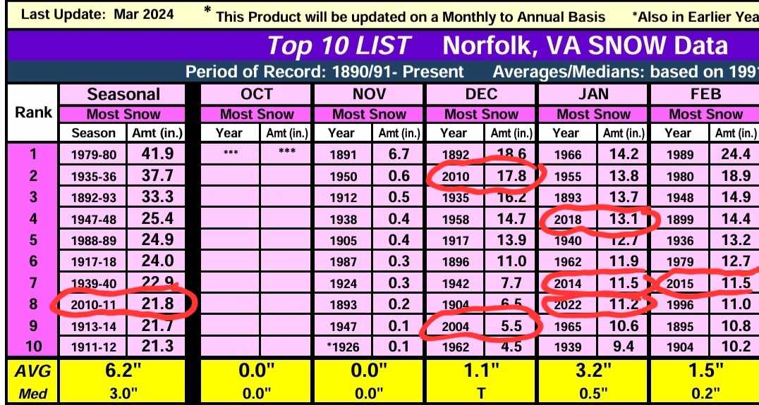
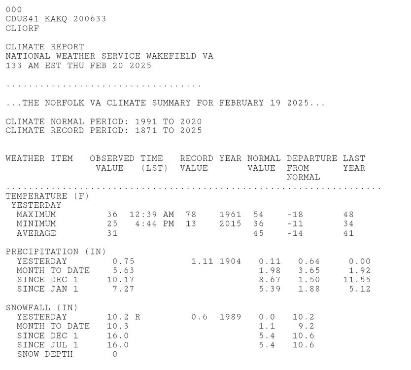
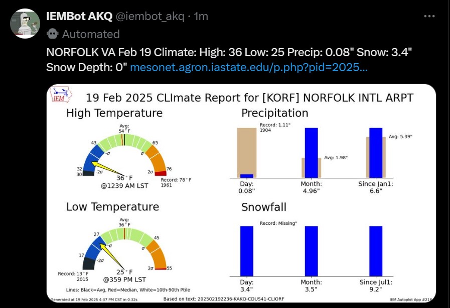
https://www.weather.gov/wrh/Climate?wfo=akq That's the link to Wakefield's climate page. You'll have to dig deeper using the NOW data for some of the info you want. But, if you click on Local Climate, they have charts for the top 10 lists for temp, precip, and snowfall for Richmond and Norfolk. Below are the largest snowstorms (4"+) in Richmond and Norfolk since 2000. I counted 10 snowstorms 6" or more in Richmond and seven snowstorms 6" or more in Norfolk. Richmond is leading the pack, but that does not mean "parts" of Hampton Roads have not had more snow than Richmond. As I mentioned in this post yesterday, Norfolk has been snowier relative to the average compared to Richmond. Richmond Snowstorms 4" or more (since 2000) 4.0" February 19, 2025 11.5" December 9, 2018 7.1" January 7, 2017 11.4" January 22-23, 2016 5.0" February 26, 2015 7.2" February 16-17, 2015 5.8" February 12-13, 2014 6.6" February 5-6, 2010 10.0" January 30-31, 2010 7.4" December 18-19, 2009 6.3" March 1-2, 2009 7.7" January 2-3, 2002 11.0" January 25, 2000 Norfolk Snowstorms 4" or more (since 2000) 11.0" February 19-20, 2025 4.0" January 28-29, 2022 6.8" January 21-22, 2022 10.3" January 3-4, 2018 5.3” January 7, 2017 5.5” February 26, 2015 8.5” January 28-29, 2014 14.2” December 25-26, 2010 6.5” January 30-31, 2010 5.0” December 26, 2004 7.7” January 2-3, 2002 4.7” January 25, 2000 -
Storm total was 4.0" at RIC, so up to 11.7" for the season.

-
Richmond Metro/Hampton Roads Area Discussion
RIC Airport replied to RIC Airport's topic in Mid Atlantic
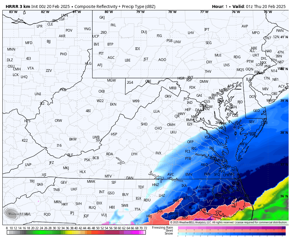
DT exaggerates so would need to verify the exact numbers. ORF may not get every storm but they've gotten more big ones than RIC. They also have a longer period of record so when you include February 2025, this is now the 8th time they've recorded a top 10 snowiest month this century, whereas RIC has only had 4 such occurrences. Here are the CLI reports for yesterday. ORF should add to theirs slightly since it was still snowing after midnight. Both stations also have a shot depending on the performance of the ULL later this morning, but both HRRR and 3K NAM seem to have it struggling once it gets east of the mountains.
-
Richmond Metro/Hampton Roads Area Discussion
RIC Airport replied to RIC Airport's topic in Mid Atlantic
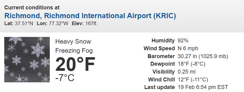
9.2" at ORF and still going.
-
Richmond Metro/Hampton Roads Area Discussion
RIC Airport replied to RIC Airport's topic in Mid Atlantic
If you send that in to NWS, it'll likely be thrown out as erroneous and not included in any official report. I'm not seeing anything close to 9" anywhere around Chester. But, I agree, the back end saved the day. -
Richmond Metro/Hampton Roads Area Discussion
RIC Airport replied to RIC Airport's topic in Mid Atlantic
00z HRRR has snow with the ULL weakening east of the mountains.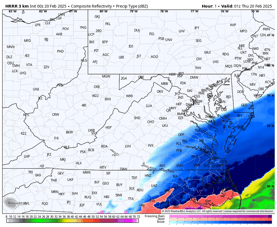
-
Richmond Metro/Hampton Roads Area Discussion
RIC Airport replied to RIC Airport's topic in Mid Atlantic
-
Richmond Metro/Hampton Roads Area Discussion
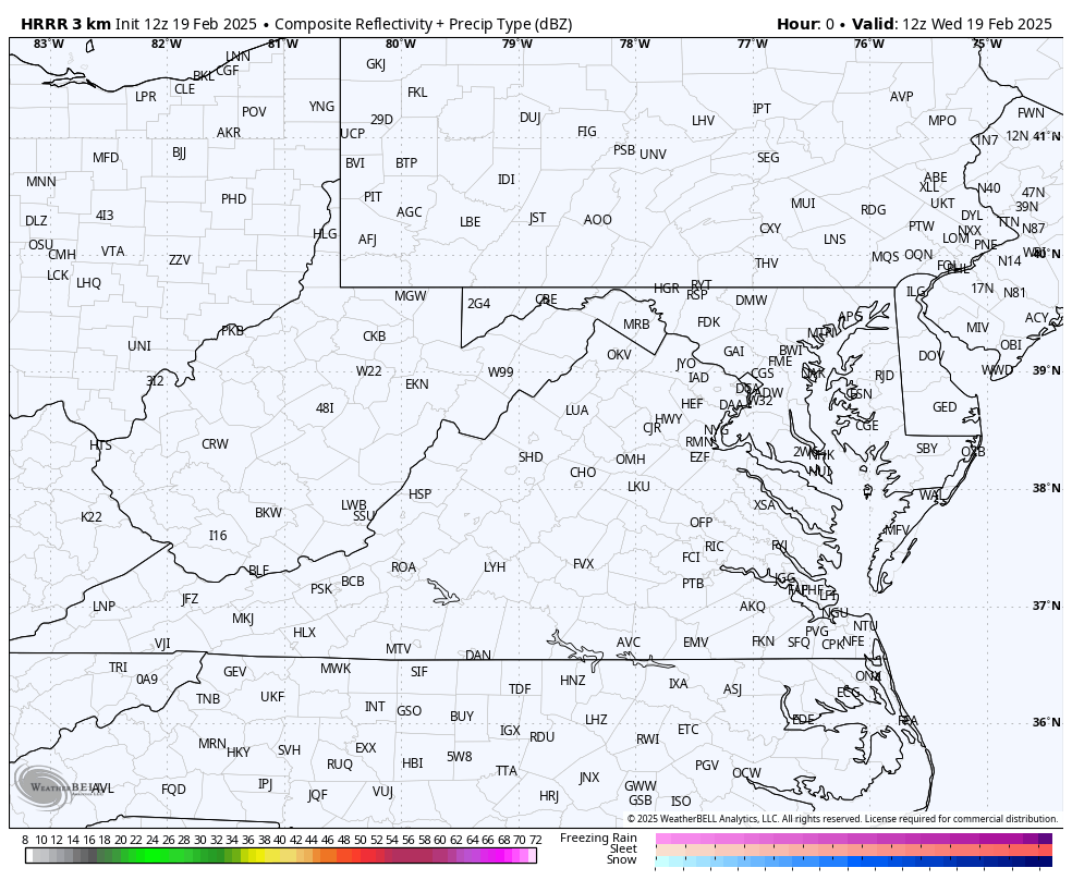
RIC Airport replied to RIC Airport's topic in Mid Atlantic
Nice banding trying to develop right over the Richmond metro. Hampton Roads getting crushed!!!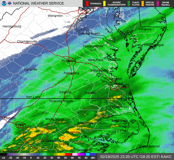
-
Richmond Metro/Hampton Roads Area Discussion
RIC Airport replied to RIC Airport's topic in Mid Atlantic
Officially 2.0" so far at RIC and 3.4" at ORF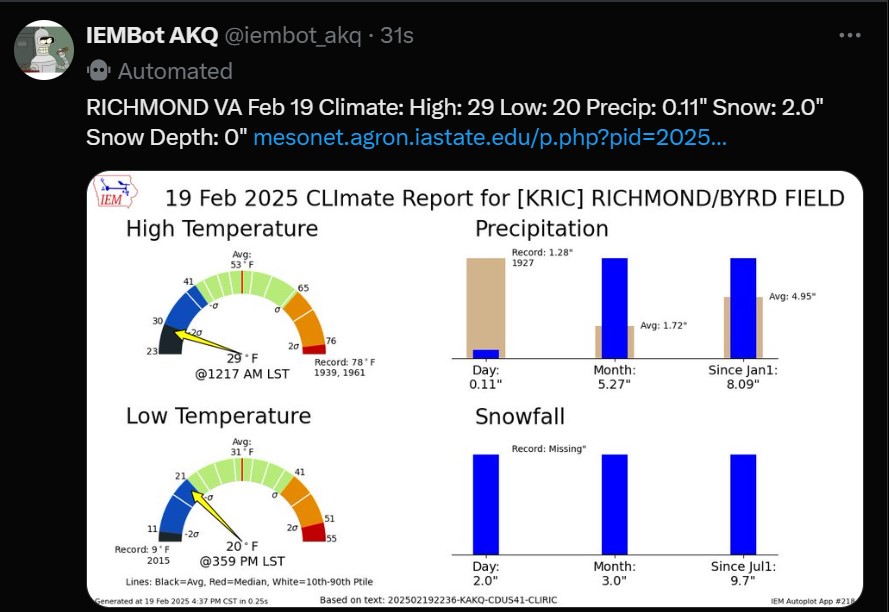
-
Richmond Metro/Hampton Roads Area Discussion
RIC Airport replied to RIC Airport's topic in Mid Atlantic
Back edge of the snow seems to be rebuilding around Farmville.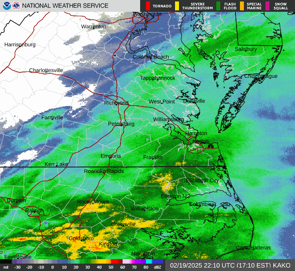
-
Richmond Metro/Hampton Roads Area Discussion
RIC Airport replied to RIC Airport's topic in Mid Atlantic
Sleet line looks to be headed your way and parts of southside HR.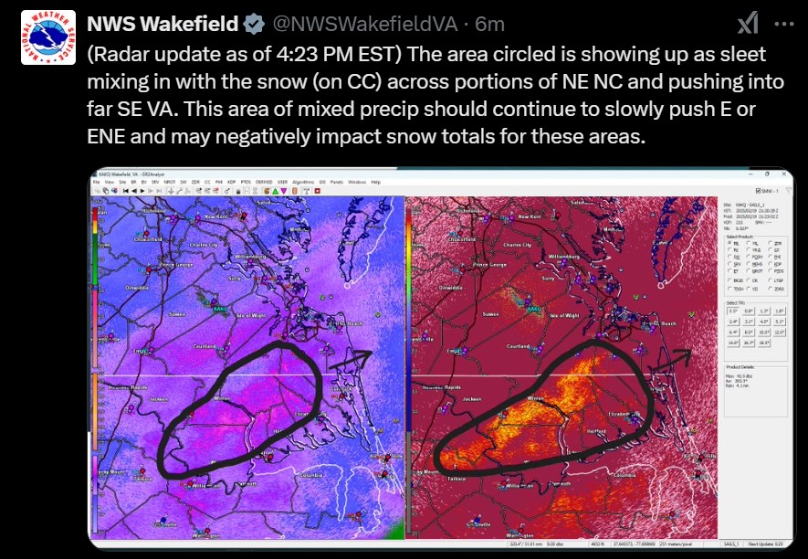
-
Richmond Metro/Hampton Roads Area Discussion
RIC Airport replied to RIC Airport's topic in Mid Atlantic
That's right, along with the others. But when it shifted SE, it was consistent with this idea. Way too many placed too much faith in the western outliers and have been adjusting east ever since. Remember when Matt Dinardo went 9-12" for Richmond 24 hours ago? It was also bad enough that within hours of him doing a live stream about his changes, with hundreds of views, the NWS upgraded the RIC area to warning for only 3-6". AKQ did much better than the Richmond TV stations. Oh, and he was the main one a few days ago telling people to listen to him and not the "social mediaologists" .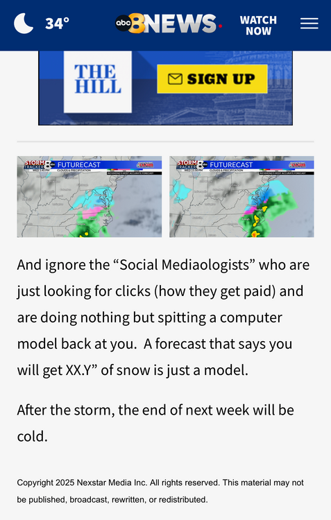
-
Richmond Metro/Hampton Roads Area Discussion
RIC Airport replied to RIC Airport's topic in Mid Atlantic
Hard to against the King. -
Richmond Metro/Hampton Roads Area Discussion
RIC Airport replied to RIC Airport's topic in Mid Atlantic
There they go again.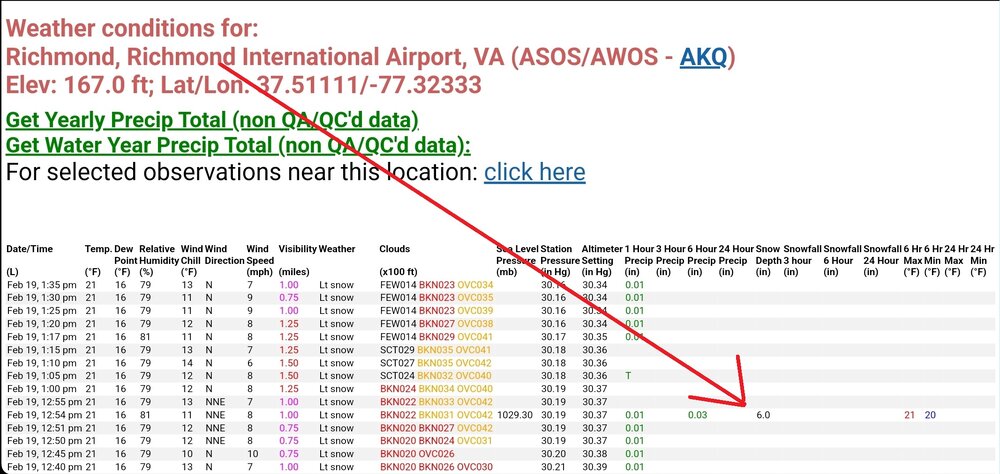
-
Richmond Metro/Hampton Roads Area Discussion
RIC Airport replied to RIC Airport's topic in Mid Atlantic
In 2023 and 2024, many areas experienced a notable lack of snow. However, there is some truth that ORF has been performing better than RIC relative to the average and certainly have gotten bigger storms. In fact, ORF was one of the few stations that saw an increase in its 30-year average when the snowfall data from 1991 to 2020 was released, whereas RIC lost 1.5 inches. For a station with snowfall observations dating back to 1874, consider how many top 10 snowfall months it has recorded this century. We can confidently say that February 2025 will be added to this list.
-
Richmond Metro/Hampton Roads Area Discussion
RIC Airport replied to RIC Airport's topic in Mid Atlantic
esoscale Discussion 0118 NWS Storm Prediction Center Norman OK 1208 PM CST Wed Feb 19 2025 Areas affected...Portions of northern/northeast North Carolina into southeast Virginia Concerning...Heavy snow Valid 191808Z - 192315Z SUMMARY...Snowfall rates around 1 in. per hour are possible within a snow band in parts of northeast North Carolina and southeast Virginia. Immediate coastal areas could see slightly higher rates. DISCUSSION...As mid-level ascent continues to increase across the Mid-Atlantic this afternoon, a coastal trough is expected to deepen offshore. By the evening, a deeper surface low should be present off the coast from the Carolinas. This process should promote low/mid-level frontogenesis across parts of the region. This already appears to be occurring in northern/northeast North Carolina into southeast Virginia. Wakefield, VA ASOS has reported heavy snow within the last 30-45 minutes. This band should continue to translate northeastward through the afternoon into the evening. Moderate to heavy snowfall is probable within this band with overall rates near 1 in. per hour anticipated. Some areas near the immediate coast may see slightly higher rates or at least longer duration snow as the frontogenetic lift should be maximized in these areas. Snowfall intensity will eventually decrease by late evening into Thursday morning. With southern extent, towards central North Carolina, more of a mix of wintry precipitation is possible along the edge of the snow band as there will be greater influence from the low/mid-level warm nose. ..Wendt.. 02/19/2025 ...Please see www.spc.noaa.gov for graphic product... ATTN...WFO...AKQ...MHX...RAH...RNK... LAT...LON 35927883 35887899 35857930 35957960 36087975 36247965 36497933 37137790 37447667 37427611 37347581 37037561 36597552 36257570 36077666 36027741 35957839 35927883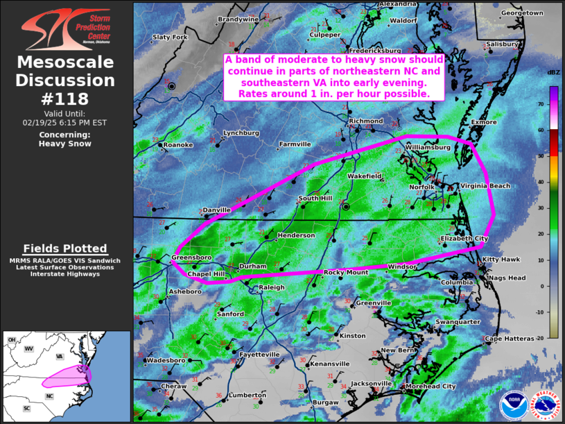
-
Richmond Metro/Hampton Roads Area Discussion
RIC Airport replied to RIC Airport's topic in Mid Atlantic
This late February sun angle sucks. Roads should start caving with any snow later this afternoon. -
Richmond Metro/Hampton Roads Area Discussion
RIC Airport replied to RIC Airport's topic in Mid Atlantic
Also, we can look at the short-range models, but they are not always precise about where bands will develop. Quite a few places well north of Richmond are doing better than expected. There could always be surprises, and we'll have to wait and see how the rest of today goes. Also, don't forget about the ULL swinging through tomorrow. It, too, could offer some surprises. Hard to say either way, models have varied on its intensity. -
Richmond Metro/Hampton Roads Area Discussion
RIC Airport replied to RIC Airport's topic in Mid Atlantic
There will probably be some fill in as the low gets closer, it's something to monitor in the coming hours. I personally would feel better if you were living south and east of the city instead of Short Pump, Midlothian or Ashland. -
Richmond Metro/Hampton Roads Area Discussion
RIC Airport replied to RIC Airport's topic in Mid Atlantic
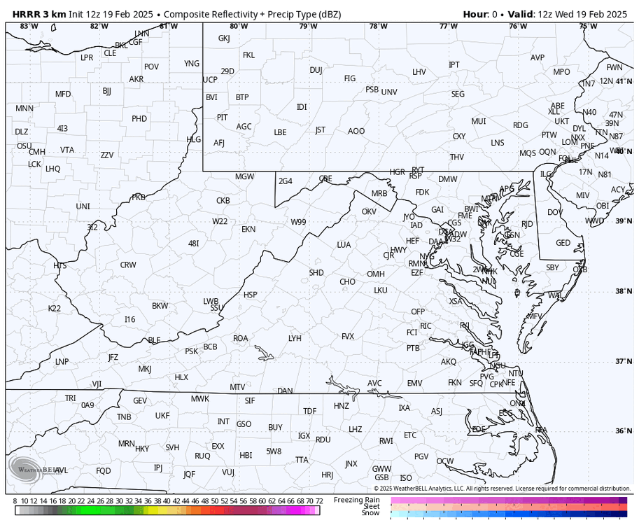
Looking at the radar, you can tell where the best snows is trying to set up.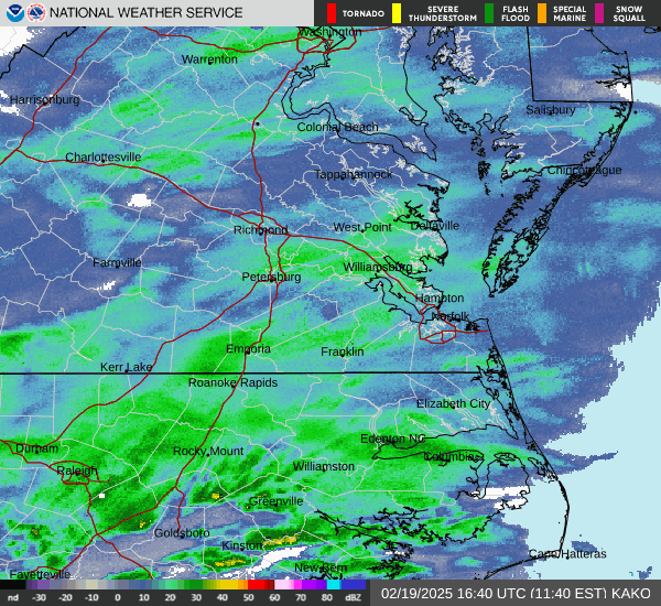
-
Richmond Metro/Hampton Roads Area Discussion
RIC Airport replied to RIC Airport's topic in Mid Atlantic
Great events, if only they happened more often. -
Richmond Metro/Hampton Roads Area Discussion
RIC Airport replied to RIC Airport's topic in Mid Atlantic
Another cold storm, just need heavier rates.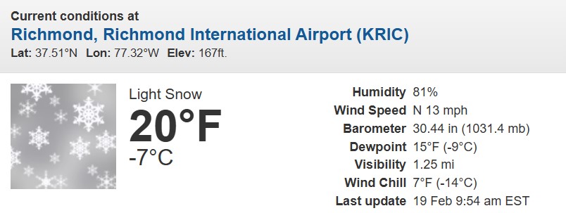
-
Richmond Metro/Hampton Roads Area Discussion
RIC Airport replied to RIC Airport's topic in Mid Atlantic
12z HRRR had the ULL moving through metro Richmond between 9am and 1pm tomorrow. Only the 6z, 12z, 18, 00z goes to hour 48.