

RIC Airport
-
Posts
2,586 -
Joined
-
Last visited
Content Type
Profiles
Blogs
Forums
American Weather
Media Demo
Store
Gallery
Everything posted by RIC Airport
-
2nd Blizzard Warning in LESS than 12 months for southside Hampton Roads. Last one issued was on 1/7/2017!!! Jealous!!!
-
One of the very heavy bands is about to enter Eastern Henrico County.
-
URGENT - WINTER WEATHER MESSAGE National Weather Service Wakefield VA 402 PM EST Wed Jan 3 2018 VAZ095-097-098-041200- /O.CON.KAKQ.BZ.W.0001.180104T0000Z-180104T1800Z/ Norfolk/Portsmouth-Chesapeake-Virginia Beach- 402 PM EST Wed Jan 3 2018 ...BLIZZARD WARNING REMAINS IN EFFECT FROM 7 PM THIS EVENING TO 1 PM EST THURSDAY... * WHAT...Blizzard conditions expected. Travel will be very dangerous to impossible, including during the morning commute on Thursday. Tree branches could fall as well. Total snow accumulations of 6 to 10 inches are expected, with locally higher amounts up to 12 inches. A trace of ice is possible as well this evening in sleet and freezing rain. * WHERE...Norfolk/Portsmouth, Chesapeake and Virginia Beach Counties. * WHEN...From 7 PM this evening to 1 PM EST Thursday. * ADDITIONAL DETAILS...Winds gusting as high as 50 mph will cause whiteout conditions in blowing snow. Significant drifting of the snow is likely. PRECAUTIONARY/PREPAREDNESS ACTIONS... A Blizzard Warning means severe winter weather conditions are expected or occurring. Falling and blowing snow with strong winds and poor visibilities are likely. This will lead to whiteout conditions, making travel extremely dangerous. Do not travel. If you must travel, have a winter survival kit with you. If you get stranded, stay with your vehicle. The latest road conditions for the state you are calling from can be obtained by calling 5 1 1.
.png.99c2e53a62bc023b1a3809ce23ad75e3.png)
-
There is potential for Richmond to remain below freezing for up to 6 straight days. All depends on whether it goes above freezing later today. (AKQ has a 32F forecast) The next blast of cold will guarantee below freezing highs until at least Saturday or Sunday before a warm up begins. If this happens, it will be the longest subfreezing stretch since February 1996. It's not too uncommon to go 3 days in a row below freezing, but beyond that, it becomes increasingly hard to do. Most consecutive days highs 32F or below at Richmond 1. 12 days (January 23 - February 3, 1936) 2. 8 days (December 29, 1917 - January 5, 1918) and (January February 7-14, 1899) 3. 7 days (December 25-31, 1935) and (December 10-16, 1917) 4. 6 days (February 1-6, 1996 and 4 previous occurrences) 5. 5 days (January 6-10, 1988 and 4 previous occurrences) **Recently there were 4 days in a row February 12-15, 2016
-
Pretty good for another decent snowfall for Hampton Roads. The following is a list of snowfalls 4.0" or more since records began, beginning with the most recent. Looks like we'll be adding to this list. Norfolk Snowstorms 4" or more (since 1891) 5.3” January 7, 2017 5.5” February 26, 2015 8.5” January 28-29, 2014 14.2” December 25-26, 2010 6.5” January 30-31, 2010 5.0” December 26, 2004 7.7” January 2-3, 2002 4.7” January 25, 2000 7.1” February 3-4, 1996 6.2” January 6-8, 1996 9.0” February 24, 1989 15.4” February 17-19, 1989 4.4” January 7-8, 1988 5.2” February 5-6, 1984 13.7” March 1-2, 1980 6.5” February 9-10, 1980 12.4” February 6-7, 1980 4.0” January 31, 1980 5.3” January 5-6, 1980 7.0” February 18-19, 1979 5.1” February 7, 1979 6.2” February 2, 1978 7.5” March 25, 1974 9.1” January 8-9, 1973 4.2” March 26, 1971 5.1” February 9-10, 1967 4.2” January 19, 1967 4.8” January 29-30, 1966 9.4” January 26-27, 1966 5.4” January 30-31, 1965 5.2” January 16-17, 1965 6.3” February 26-27, 1963 4.2” January 28, 1962 4.0” March 1-2, 1960 11.4” December 11-12, 1958 4.1” January 14-15, 1957 5.3” January 19, 1955 4.7” January 11, 1955 12.4” February 10-11, 1948 5.8” January 31-February 1948 5.3” March 8, 1947 4.2” February 23, 1947 4.5” January 8-9, 1944 4.0” December 20, 1942 5.8” February 27-March 1, 1941 4.6” March 24-25, 1940 5.8” January 23-24, 1940 6.0” January 8, 1940 8.8” January 16, 1939 11.0” February 7, 1936 5.7” January 27, 1936 7.2” December 29-30, 1935 9.0” December 22-23, 1935 6.0” March 10, 1934 6.0” February 25, 1934 4.0” January 29-30, 1930 11.0” March 2, 1927 4.0” January 10-11, 1927 4.9” March 13, 1926 5.5” January 25, 1926 6.0” February 15, 1922 7.4” December 11-12, 1917 5.1” February 13-14, 1916 4.0” December 12, 1915 5.0” March 22, 1914 6.5” March 12, 1914 7.0” March 6, 1912 5.0” March 3-4, 1912 7.0” January 7-8, 1912 4.0” January 17-18, 1911 4.0” January 31-February 1, 1910 5.5” March 20-21, 1908 4.0” March 24, 1906 6.4” December 15-16, 1904 7.0” February 10-11, 1904 8.8” February 15-17, 1902 6.0” February 23-24, 1901 13.5” February 11-14, 1899 4.0” January 28-29, 1899 11.0” December 2-3, 1896 5.6” February 7-8, 1895 6.6” February 25-26, 1894 9.8” January 19, 1893 18.6” December 26-28, 1892 6.7” November 29, 1891
-
ORF's snowiest month occurred during the La Nina winter of 1988-89. http://www.13newsnow.com/news/local/counting-down-the-regions-top-five-snow-storms/382593325
-
From what we've seen over the years, they come out of their hiding when it actually does snow. Haha.
-
You're in the AKQ CWA so you're cool. ;-)
-
I've been posting on these boards for many years going back nearly 15 years now. As I've said previously, from a climate standpoint, particularly when we consider snowfall climatology, we do not belong in the SE thread. I would argue, especially for the Richmond area, that there is a higher correlation with DC than Raleigh. The winter of 2007-8 was the first time I created a thread for us and I contemplated including Hampton Roads because often times there is a big disparity with snow between the two regions. Think of two weeks ago and numerous other examples. But, since I wanted to generate more posters I felt compelled to include the two metro areas. This is a DC centric forum. That is the whole point of this thread so that we had a place to escape and focus on our unique area. But, if people post in the other threads or quitely lurk without contributing here, then this idea becomes meaningless.
-
Radar has really blossomed last hour or so.
-
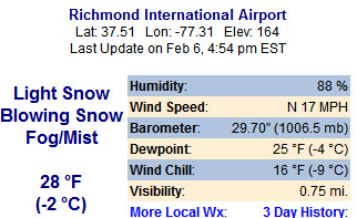
Airport is back to ALL snow as of 7pm ob. Snowdepth was 1 inch.
-
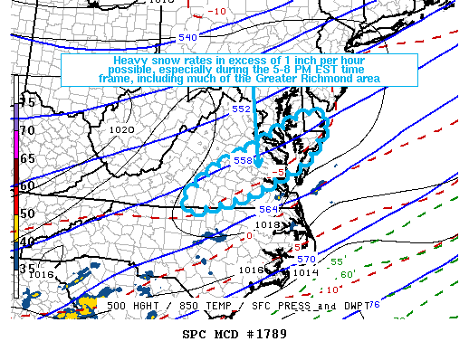
Mesoscale Discussion 1789 NWS Storm Prediction Center Norman OK 0152 PM CST Fri Dec 08 2017 Areas affected...Parts of southern/eastern Virginia into the Delmarva Peninsula Concerning...Heavy snow Valid 081952Z - 090045Z SUMMARY...Heavy snow rates around or in excess of 1 inch per hour could develop and impact Richmond and surrounding areas of southern and eastern Virginia by early evening. This could commence as early as 5 PM EST and continue through the 8-9 PM EST time frame. DISCUSSION...Strengthening large-scale ascent is contributing to increasingly saturated thermodynamic profiles and precipitation rates across much of southern through eastern Virginia. This appears likely to be aided by a zone of enhanced lift associated with mid-level frontogenetic forcing, which is forecast to redevelop northeast of the central Appalachians through the northern Mid Atlantic Coast region by early this evening. This is expected to increase lift through the favorable mixed-phase layer for large dendritic ice crystal growth, which could potentially provide support for heavy snow rates. Generally west through north of the Hampton Roads area, roughly from near Danville through much of the Greater Richmond area, northeastward into the Delmarva Peninsula, models suggest that temperature profiles are generally below freezing. Current surface temperatures/wet-bulb temperatures appear marginal for snow reaching the surface. However, with the onset of nightfall, and perhaps weak low-level cold advection and cooling associated with melting precipitation, a changeover to snow appears possible by the 22-23z time frame, if not before. Heavy snow rates around or in excess of 1 inch per hour appear possible, and may continue into the 01-03Z time frame, before diminishing. ..Kerr.. 12/08/2017 ...Please see www.spc.noaa.gov for graphic product... ATTN...WFO...PHI...AKQ...LWX...RAH...RNK... LAT...LON 36807940 37537853 38057728 38907564 38747491 37727568 36887751 36447929 36807940
-
It's too bad that the advertised pattern isn't happening a month later. Below are the measurable snowfall events since 1897 for the first 20 days of December. Definitely doesn't bode well if we are looking for a large event. Plus, there hasn't been any measurable December events since 2010. RICHMOND Snowstorms December 1st-20th 1.0” December 19, 1901 0.9” December 9, 1903 3.0” December 10, 1904 1.3” December 12, 1904 4.2” December 15-17, 1904 0.8” December 15, 1905 0.5” December 16, 1909 0.6” December 5, 1910 0.1” December 7, 1910 0.6” December 9, 1912 0.6” December 12, 1915 0.2” December 16, 1915 6.2” December 18-19, 1916 10.4” December 12-14, 1917 0.2” December 19, 1922 1.0” December 14, 1923 1.2” December 8, 1922 6.0” December 17, 1930 1.0” December 9, 1931 7.5” December 17, 1932 0.1” December 11, 1933 3.2” December 10-11, 1934 0.1” December 5, 1937 0.5” December 13, 1937 0.7” December 7, 1942 0.8” December 16, 1942 4.5” December 20, 1942 0.6” December 13, 1945 3.1” December 15, 1945 4.5” December 18-19, 1945 0.3” December 13, 1946 0.7” December 10-11, 1950 2.2” December 5-6, 1954 2.1” December 4, 1957 0.8” December 11, 1957 6.7” December 11, 1958 5.8” December 14, 1958 1.2” December 19, 1959 1.7” December 12, 1960 0.3” December 9, 1961 0.1” December 9, 1962 0.1” December 11, 1962 0.4 December 18, 1963 0.3” December 13, 1966 2.8” December 7, 1968 4.4” December 11, 1973 4.3” December 16-17, 1973 1.7” December 8, 1976 0.7” December 15-16, 1981 6.1” December 12, 1982 1.8” December 19, 1982 1.3” December 20, 1985 1.8” December 9, 1988 5.9” December 8-9, 1989 5.0” December 12-13, 1989 0.8” December 19, 1989 1.5” December 7, 1995 1.0” December 19, 1996 1.0” December 19, 2000 5.0” December 4-5, 2002 1.3” December 19, 2004 4.4” December 5-6, 2005 7.4” December 18-19, 2009 0.6” December 4, 2010 1.1” December 13, 2010 2.0” December 16, 2010 11.5" December 9, 2018
-
Looks like there is an issue with the Richmond ASOS. You can see the sporadic temperature readings shortly after midnight. Take note, in particular, the intrahour obs. http://www.wrh.noaa.gov/mesowest/getobext.php?wfo=sew&sid=kric&num=60&banner=on The CLI that was sent showed RIC hitting 75 degrees today, but clearly that is incorrect.
-
Time for a new winter thread and lets hope there will be plenty to talk about. By the way, for the first 11 days of November, only three other days had high temperatures colder than yesterday at Richmond. Those days were 11/11/1987 (36°F), 11/6/1953 (38°F) and 11/11/1913 (41°F). Interestingly, the first two occurred on dates with two of the largest November snowfalls at RIC.
-
7" officially at RIC. We got dry slotted so although we didn't get the HUGE totals, still a decent event, particuarly when you consider about 6" was still leftover on the ground from the storm a week earlier.
-
Although we didn't get the HUGE totals, still a decent event for Richmond, particuarly when you consider about 6" was still leftover on the ground from the storm a week earlier.

-
I looked below and noticed it was your birthday! HAPPY BIRTHDAY....hope it's utterly fantastic!
-
I was wondering about that. But, I thought it was these god forsaken gov't computers that tends to block images. I will try to fix it.

