

Lookout
-
Posts
5,769 -
Joined
Content Type
Profiles
Blogs
Forums
American Weather
Media Demo
Store
Gallery
Posts posted by Lookout
-
-
19 minutes ago, SnowDawg said:
Spot on with this. Will be interesting how that trend plays out. Heavy shower came through here and dropped it down to 35.2 and the HRRR just initialized with me at darn near 40.
yeah the hrrr is always...always...too warm in these situations at the surface. With constant rain and the onset of cad, i don't expect any rise in temps across north ga which means by this afternoon the hrrr could end up being about 5 degrees too warm on average by this afternoon in spots. These 3 to 5 degree biases are right right on average in cad.
I'm also think they are way too warm sunday night into monday at the surface and 950mb which is in part causing the models to spit out rain instead of snow. What makes it even more unlikely is the fact the models are showing temps rising into the mid to upper 30s at NIGHT with still NE flow. There is some downslope warming possible over parts of far north of ga but for everywhere else I'd be truly shocked if that happened. So don't be surprised if that is snow instead of rain monday in a lot of places.
-
 4
4
-
-
a note on the 3km and 12km nam, currently it's running on average about 3 degrees too warm right now here in georgia and in a lot of areas seeing rain. If it held this average error into tonight, temps would get to freezing in gainesville/85 corridor between 0z and 03z where it gets these areas down to 34 by 03z.
-
3
-
-
12 minutes ago, SnowDawg said:
This is precisely my concern right now. Last night models were showing changeover here between 11 am and 1 pm, hence GSP moving my WSW up to noon. But temps have been 3-4 degrees or more above forecast all night long and continues to refuse to budge this morning. I know that we’ll see changeover by the heart of the storm, but going to miss out on a lot more qpf than initially expected before then.
Local temps are as low as 33 at sky valley and 38 at the dot station in clayton currently which is about where they should be. I haven't seen anything that has changed that would lead me to believe your changeover wouldn't be around mid day to early afternoon.
-
 1
1
-
-
47 minutes ago, UpstateSCGamecock said:
GSP’s discussion page doesn’t give much hope for snow south of 85 and they are not sure if frozen gets to advisory criteria. Your post gives me hope. Thanks for the informative posts for your neck of the words. That would bode well for me in S of 85 in SC.
.Well it's certainly by no means a lock and the chances are based on the fv3 and euro mainly...nam says no and the hrrr says it's sleet (or maybe some snow mixed in..it's hard to say since i'm near 100% positive it's surface temps are several degrees too warm as is usually the case in these situations and could be throwing it off). If it happens, it would be sometime between 01z/02z and 06z in ga and 09z in sc as the fv3 also brings the warm nose screaming in.
it would be nice to see the nam come on board but the 12z run is holding firm.
.thumb.png.14973c5a0ee9a74068261f363288fda8.png)

-
1 hour ago, msuwx said:
Well, been pouring through all available data for hours now, and it all depends on the temperatures 5-9k feet aloft for much of the region tonight into Sunday morning.
NAM really warms temps in those layers later tonight....some other models do not.
The NAM often does well in this situation, but I'm more hesitant than normal this time. Makes a massive difference in ground accumulations, especially around CLT-RDU corridor.
I wonder if the intense precip rates could offset that warming somewhat or delay it?
Speaking of those intense rates, most of the models are now showing enough heavy precip/cooling for a several window of very heavy snow or sleet across ne ga...maybe as far south as athens, before going back to sleet/freezing rain (mainly north of 85 until after 09z) overnight tonight as the warm nose aloft moves in. (just for reference it's all snow/subfreezing at 06z but warms to plus 3c at 750mb on the fv3 near cornelia at 09z). There does appear to be some dynamical cooling at play here with very intense precip rates and cooling occuring at the same time. ...in fact the 06z run it keeps it as sleet for areas like gainesville to hartwell for the duration of the storm after 03z. Would be quite the accumulation of it if that happens.
i sure envy the upstate/western nc. The rates are going to be insane.

-
2
-
2
-
 1
1
-
 1
1
-
-
23 minutes ago, SnowDawg said:
Here in Rabun I am absolutely getting much more confident since last nights and this mornings runs, and hope you are right. But still being cautiously optimistic until I see exactly what our temp and dew point are in the morning. Currently 43 with a dew point of 26.
If i could have i would have took off to clayton again because i think they will do really well but unfortunately there are things going on keeping me from doing it. At any rate, i'd be excited if i was you. It looks like once mixed precip or snow starts mid morning tomorrow it shouldn't stop for a long time and It's just a matter of how much of which....although if that warm nose above 850 isn't as strong as advertised or rates are heavy enough it could very well end up being mostly snow...except the light freezing stuff after the dry air punches in aloft sunday.
-
Just now, griteater said:
Euro

this run of the euro sure gives hope that there could be quite a bit more snow/sleet in northeast ga than before. Now has precip changing over to all snow for a while down to places like gainesville and hartwell with a mix here before the warm nose aloft moves through. That snow would could help drop temps to freezing earlier by several hours which could mean more freezing rain, again especially along and north of gainesville to hartwell but that's hard to say yet.
It's only going to one more small downward temp adjustment aloft to make potentially change things quite a bit...maybe even south of 85. Damn shame though that the warm nose is still there above 850mb....but given precip rates, makes me wonder if sleet will be more expansive. That said, this should be quite a hit for NEGA, rabun county, and those areas.
-
1
-
2
-
-
1 minute ago, Ontherocks said:
Will the fact that the rain has already arrived in NGA have an effect? Keep our temps cooler? This precip seems earlier, as there was suppose to be some sun today.....looks like the NAM maybe showed this some
It will have an effect today...in fact it will be a lot colder....up to 15 degrees colder than all of them showed 2 days ago. Unfortunately it doesn't have much impact on whatever falls saturday. Sort of frustrating it can be 15 degrees colder the day before and not really matter lol
Just now, NEGa said:its hard for here as well since its such a close call. I am hoping the slightly south trends mean the CAD will be coming in a little stronger. However, historically for NE GA, at least, CAD events are ice ice baby. Sometimes a front end thump of snow but usually ice (since I am apparently one of the "odd ones" who enjoys all winter wx a good ice storm doesn't really bother me). my issue with a good glaze is more how heavy the precipitation is. if its too heavy and not into the 20s it might not really ice over all that much
You are in a much improved spot vs 24 hours ago. If the latest few runs of the fv3, euro, and nam are correct, you will get a lot more sleet/snow. You are right about the precip rates/freezing rain though...it's one reason why i haven't been too excited about it outside the higher elevations/your area and the rates/marginal temps would keep accretions down. That said, nam has 950mb temps dropping below freezing as early as late afternoon tomorrow over your area so you should get quite a bit of wintery precip.
-
12 minutes ago, beanskip said:
Wow -- huge surge south of 850 temps vs. 6z run -- about 50 miles south at 30 hours.
yep....850 mb low and thus winds are more easterly than southeasterly in the upstate and north ga. it's very very close to snowing in much of ne ga by late in the day. The killer for north ga continues to be the warm nose the nam shows between 700mb and 850mb though but it's much cooler this run with it. Considering how heavy the precip is i wouldn't be surprised to see a lot of mixing though now just about area wide.
Also, the trend in the models here lately is to be a little further north with that finger of precip. That has possible cooling ramifications for ne ga too as the air is colder over the western carolinas so after wetbulbing that air advects into north ga. It does north ga no good to have it so far south as the models have been showing until recently.
Overall a much better look if one is hoping to see something other than freezing rain or rain in ne ga and a better overall snowy look for the upstate.
-
1
-
-
49 minutes ago, isohume said:
The EC was used and weighted along with some GFS/CMC fields. The NAM profiles were not incorporated as it was deemed too warm at h85 and was an outlier, but will be watched for further trends. In my personal experience the NAM normally does quite well with the warm nose in this area.
I was quite surprised the nam's profiles were dismissed as i'm sure many were because of that. Interesting decision.
33 minutes ago, olafminesaw said:Bullish as always

i love how he has athens being marked in elbert county instead of where it's really at, clarke.
-
1
-
 4
4
-
1
-
-
Just now, Wow said:
GFS definitely trending toward its successor WRT the upper level low swing through early Tuesday
not very often you see an upper low diving southeast into georgia...drops another 0.25 to 0.40 of mostly snow too. hopefully the fv3 is even more bullish.
0z canadian does the same thing btw.
-
1
-
-
Just now, griteater said:
yeah wow, the GFS is looking much like the FV3 on the backside wave dropping in...who knows how strong that precip will be, but an impressive evolution this far south
yeah precip redevelops with it too...
-
Just now, Wow said:
It's the GFS, and at this range what's the surprise?
Even for the gfs, that's pretty bad. That's more like the old avn type of busts.
-
1
-
-
well the 0z gfs holds in showing much warmer temps. If our suspicions are correct, this could be an epic bust on it's way out the door. Nam is up to 8 degrees colder than the gfs over north ga.
-
1
-
1
-
-
Just now, oconeexman said:
at hr84 the wedge is in full effect here and Nega..dew points remain in mid 20's with almost an inch of liquid. I'm very optimistic that this will be a great event for NW SC and parts of Nega despite what any clown maps have shown and will continue to show. Ive learned one thing over the years on here and that's to look at specifics instead of clown maps...although theyre fun or depressing to look at. Looking forward to your input in the next 3 days!
The 0z nam is a little slower than the 18z run in dropping temps but it happens very quick when it does. Interestingly the nam is showing the core of the cold air at 950mb instead of 925mb this run. I wouldn't be surprised to see it speed up by a number of hours again since i suspect the nam, nor any model, will be able to accurately get down the quick cool down over the western carolinas where the whole atmosphere is quite a bit colder/drier. Also, nam is showing quite a bit of mid level cooling and given the cold low levels i suspect there could be quite a bit of sleet over northeast ga....especially considering precip rates. But watch levels between 850mb and 700mb...warm nose there could screw the upstate's snow for a little while. Nam, not surprising is more bullish with it than the gfs.
-
1
-
-
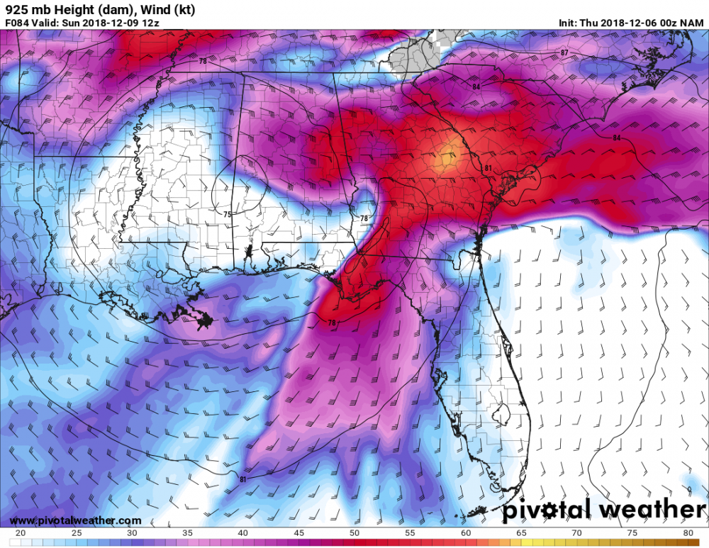
This is pretty crazy......925mb winds of 50 to 55 knot winds across damming regions of ga/sc by sunday 12z. 40 knot winds at 950mb. 10 meter 20 knots. It's Some serious wedging lol
-
4
-
-
4 minutes ago, UNCCmetgrad said:
18Z FV3 gets some fzrn all the way back to Atlanta this run. Significant icing NE Ga, most of Upstate to areas south and east of CLT.
pretty fun looking run right into next week....although not much fun about damaging ice....although i'm hopeful that sleet might save the day for areas north of athens while snow could pile up north of 85 if this run is to be believed.
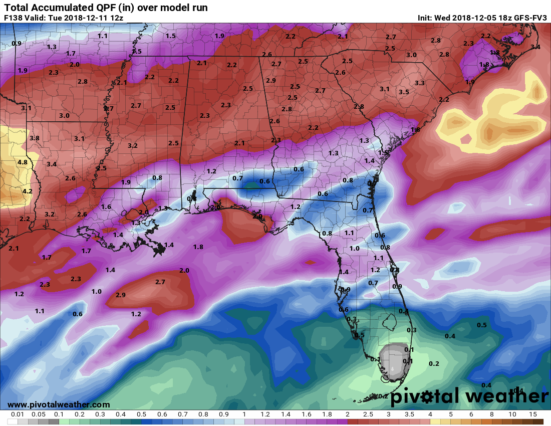
very wet run though...nearly 3 inches of liquid close to here and approaching 3 inches in western nc.

-
8 minutes ago, oconeexman said:
Getting better and better for us Cad areas! Looking forward to some juicy Nam runs
yeah this run finally looks like it bought a clue. There have been times the models have shown some cooling of the mid levels over the heart of the cad regions and it's something to watch for as we get closer...could mean more snow/sleet further south than expected. I wouldn't be surprised to see snow/sleet mixing here at times. What i wouldn't give for just 1 or 2 more degrees cooling aloft.
-
1 minute ago, burgertime said:
This is what I was worried about earlier with the 12z runs. Someone is going to get a bad ice storm out of this. This looks like a strong CAD setup on the models...with a lot of moisture so someone will get the brunt of this in a bad way.
I've been conflicted about this due to the lack of low surface dewpoints and the fact that most of our ice/winter storms don't have a long period of just plain rain before hand. (instead just a few hours as we wetbulb down) But every other major indicator i look for is there. Some of it is just general things i have noticed over the years...like it normally ices here if the 0c 850mb isotherm starts south of the nc/sc border, Not only does it do that but it touches ne ga as well. 850s never get above a few degrees above freezing, very deep east/northeasterly flow...all the way up to at least 875mb (which is higher than average)......indeed even the 850mb level has that wedge look which is an indicator of a really good one, tight pressure gradient, and strong boundary layer winds.... latest nam is showing 925mb winds at an impressive 45 to 50 knot across north ga by hour 84.
The good news for north of 85 is that it might get could enough to make for more sleet than freezing rain because of the cold low levels and mid level temps actually cooling at times. It would be nice if that sleet makes it this far south. Earlier runs of the euro had it very close to doing that but i fear the odds are more likely it's freezing rain for the most part here unless 900 to 975mb temps trend colder or mid levels are a bit cooler.
-
5
-
-
Just now, beanskip said:
Interesting -- 850 temps LESS impressive, but dewpoints, surface temps colder. Sounds like an icy setup to this old coot.
after a ho hum run this morning, this run is pretty scary looking for northeast ga in terms of ice potential. 925mb temps plummet by sat evening....on the order -4 to 5c... with surface temps dropping below freezing by midnight or so,,,even down to the northeast burbs of atlanta with a lot of precip left to go.
-
4
-
-
7 minutes ago, msuwx said:
Time for my semi-annual pet peeve post. One shift does not equal a “trend.” You need multiple, subsequent movements of something in the same direction for it to be a trend.
In other words, multiple model cycles in a row, not 1.
lol...amen.
5 minutes ago, Queencitywx said:Thank you for that, matt. Also my pet peeve.
Mine too...probably my top one. I understand it if someone is a noob but what's frustrating is you see people who have been around long enough to know better do it.
-
1
-
-
Just now, UpstateSCBud said:
I'll take that bet. Living in upstate SC for 30 years can make one quite the pessimist. I've even come up with my own formula to determine snow amounts. Take whatever is being modeled/forecasted and cut it in half. Take that total and cut it in half again. Whatever is remaining from that total, assume at least 1" of it will be either sleet, freezing rain, or cold rain. Be happy if what's left of the total is snow.
I'd be pretty excited if i was in the upstate because i think it's a given right now that most of the precip will be of the winter variety in some form or fashion.
3 minutes ago, No snow for you said:I hope I didn’t come across as complaining. Just commenting the GFS doesn’t show much for GSP. I agree it is one model run with a model that will not exist In a month.
It's ok, i wasn't directing that at you but that being said just a little less banter/one liners and taking the gfs at face value with cad would probably be better.
")
As i said above, i'd be happy if i was where you were. Of course my standards are a lot lower probably.
-
1
-
1
-
-
Just now, SLAMSTORM22 said:
Ridiculous analysis and comments again off one run of the flip floppiest models the GFS. Follow the Ensembles... Sheesh
enough complaining. if you don't like it, leave.
-
7
-
5
-
3
-
1
-
2
-
-
8 minutes ago, SnowDawg said:
Surely that CAD would be stronger? I mean the high definitely rockets out of there late but for a good portion of the event it is locked in there yet the 850s are very warm this run. Interested to see where the OP GFS stands within its suite.
The pressure gradient and packed isobars are impressive with this system. In general all show a 12mb pressure difference across ga and 20mb from west ga to nc at it's maximum. That's about as good as one can hope to see. Indeed you see it in the 20 to 40 knot low level northeasterly flow across ga/carolinas. If the nam is correct in it's depiction of lower dewpoints, surface pressures, and much colder low levels, you can pretty much toss the gfs surface temps in the trash.
-
1
-
1
-
.png.de916964f655b0bd32a5c7d0dbd82248.png)

December 8-10 Winter Storm Obs
in Southeastern States
Posted
Looks like it's changing over in rabun county. Now some 31/32 degree temps at tallulah and highlands. Even though saturated, tallulah feel 3 degrees in 2 hours.