

Lookout
-
Posts
5,769 -
Joined
Content Type
Profiles
Blogs
Forums
American Weather
Media Demo
Store
Gallery
Posts posted by Lookout
-
-
2 hours ago, FallsLake said:
Yep, if I was in NW NC up towards your area I would start looking at this closely. Even down towards my area there could be some brief mixing; which I would call a win.
Winter has sucked so bad here that a 33 degree rain could be considered a win.

-
 3
3
-
 1
1
-
 2
2
-
-
32 minutes ago, Queencitywx said:
2-3 inches from roughly Hickory to Durham-ish followed by a significant to damaging freezing rain event.
i'd honestly be a little surprised if north carolina doesn't get something frozen or freezing over the next 10 days. Looks like this hot garbage of a winter will continue for ga though unless the models are faster with the highs building into the mid atlantic/northeast or we see things shift south..which lol...we know that won't happen.
-
On 2/7/2019 at 5:40 PM, BK Rambler said:
Maybe because there was such a consensus for a cold and stormy winter in the South and East from so many that we respect and we got teased by the cold November and the early December big dog in NC. A lot of people scoff at the Old Farmers Almanac but they've done better than most for this season - no disrespect to the bustees - it's definitely an art more than a science still.
Yeah all the "certainty" and general bullish calls is certainly apart of why. I'm a realist and know what to actually expect...which in general is worst case scenario but one would think given all the bullish calls, it wouldn't have been this bad.
4 hours ago, Iceagewhereartthou said:I feel like we've seen a ton of these maps this year and, well...we know what happens. Even verbatim, this would do nothing for I-85; this is all west of apps/ north of I-40 stuff.
Was wondering if it was just me but as I said this the other day, i don't think i've ever seen so many fictional cad/winter events in the long range than i have this year.....yet none of them have actually materialized which is quite remarkable. That has helped in adding to my frustration of this year too. It's nothing new to see fantasy storms never materialize but damn....You would think that at least ONE of the 100 that have been shown the past two months would actually verify.
1 hour ago, WSchew said:Someone please drop some ensemble maps in lieu of the clowns above.
Not even worth it, zero support on the 18z gefs..at least in terms of temps. There was actually more on the 12z run but still not a lot.
-
3 hours ago, SENC said:
And... Breaking news..
Hawaii recorded what may be the lowest elevation snow in state history..
(below 6K feet)..
https://www.sfgate.com/weather/article/Hawaii-recorded-what-may-be-the-lowest-elevation-13607099.php
Was going to post this,...it's absolutely crazy to see snow down to 6200 feet there.
-
8 hours ago, JoshM said:
V3 is now rain and 60s on Tuesday


I laughed
 Pathetic but predictable.
Only hope i have of seeing a thing seems to be sunday if enough precip develops since temps/wetbulbs certainly start cold enough....but precip looks so marginal/light we won't be able to take advantage of it. At least it will likely keep temps down all day and it will feel like winter rather than freaking may. What a sad excuse of a winter where a raw mid to upper 30s day is looked at as some type of victory.
2 hours ago, FallsLake said:Only 15 days out.......:
I'm not sure i've ever seen so many fantasy storms on the gfs that never actually materialize than this year.
Meanwhile, it's freaking 81 here right now. I just can't get over how horrible the winter outlooks have been. Normally when they bust they don't bother me because as i said the other day i never put any stock in them but this year it's really bugged me for some reason.
-
11 hours ago, LithiaWx said:
Is there any hope? This is depressing.
Not much.
Funny though, i thought it wasn't supposed to be this crappy.
I have never nor do i now pay any attention to winter outlooks but it's hard to miss considering how much people talk about them....however, I have to say i can't believe anyone pays attention to them. I know a lot of people try their best and put a lot of work into them but regardless of how many big words they use, how many analogs, or how many indexes they come up with.....it's still no better than flipping a coin...indeed it seems to be worse than flipping a coin. Maybe one day someone will crack the code but given the amount of inherent chaos in the system i doubt it.
-
4
-
-
38 minutes ago, LithiaWx said:
Kids in the entire Atlanta metro are out of school for a little rain and some drizzle. Most of us didn’t even see a flake. Not a single damn flake.
it was pretty insane how much local media was playing it up. Even for the south it seemed absurd. glad you got to srr at least a few flakes though.
-
1
-
-
1 hour ago, eyewall said:
As usual, cold air chases almost never work out. This is no exception. The writing was on the wall well before this morning.
yep..for sure it almost never fails it will dissappoint.. .this never looked too promising except in alabama but it was obvious laat night the cold air was lagging too far behind. feel for northern alabama...had a warning and pretty much got nothing. at least here there was never a chance.
this winter sucks.
-
35 minutes ago, Lookout said:
gfs and euro ensembles look pretty decent for the nw half. ....but of course areas to the east of 85 look pretty much screwed with the leeside screwzone in full effect...which means i'll likely have to make a trip to see it. But an inch or two looks possible and north/west of an atlanta to gainesville to clayton line. In fact some of the euro ensembles show several inches for the mountains.
Would love to see this thing put down a few inches ahead of this arctic airmass to maximize the low temp potential. Although the euro doesn't look nearly as impressive with the outbreak as it once did.
speaking of that..the 12z icon goes nuts over tn thanks to that snow cover..5 to 15 below

unfortunately looks like it screws ga/sc snow wise (east of atlanta/gainesville). does keep temps in the 20s for highs though, even here in the heart of the screwzone.
-
3 hours ago, LithiaWx said:
Gfs much wetter for north Ga for the potential Tuesday event
gfs and euro ensembles look pretty decent for the nw half. ....but of course areas to the east of 85 look pretty much screwed with the leeside screwzone in full effect...which means i'll likely have to make a trip to see it. But an inch or two looks possible and north/west of an atlanta to gainesville to clayton line. In fact some of the euro ensembles show several inches for the mountains.
Would love to see this thing put down a few inches ahead of this arctic airmass to maximize the low temp potential. Although the euro doesn't look nearly as impressive with the outbreak as it once did.
-
Just now, Queencitywx said:
Next thursday might be the coldest day of the year.
if the 12z gfs is right with highs in the teens up your way, it would be impressive if it wasn't the coldest day lol. Even the downslope screwzone might stay below freezing.
for several runs now the gfs has been showing dewpoints that if came to pass would surely be some of the lowest we have ever seen.....and to see it over such a large area is even more impressive. Although WAA commences after this, Have to believe the gfs is too warm though with morning lows the next day with high pressure becoming situated directly over head in the carolinas thursday night/friday morning with dewpoints still in the negative teens.

-
2 hours ago, msuwx said:
FYI, today’s system isn’t slower than expected. The heaviest precip was always tonight for the Carolinas.
The reason some people missed out on the earlier (and icy) precip this morning is actually because the initial airmass was drier than modeled. Dewpoints were way below model projections yesterday afternoon, and that dry air was a lot for the initial round of isentropic lift-generated precip to overcome.
yep, everything was always dependent on enough precip falling to take advantage and unfortunately it was just bone dry. Story of the winter so far south of nc...just can't get anything to come together right.
Still this was a fascinating day here with the warm front and something happened that is pretty rare...the warm front moved through but then pushed back slightly south. Normally of course once it comes through it keeps going or at least doesn't come back. Athens observations bear it out...the warm front moved just north of here and then came back south. Temps went from the mid 40s to the upper 60s and damn near 70 only to fall back into the low to mid 50s the past few hours. Meanwhile just to the south it's still in the mid to upper 60s. A few miles to the north temps mostly stayed in the 40s. Indeed at one point, one observation site just a couple of miles away from athens airport was 10 degrees warmer. Personally, cad/wedges aren't just about ice/snow so this is pretty neat to me.
Here is athens observations this afternoon.
23 Jan 5:51 pm	53	44	71		ENE	9 		10.00		OVC046	29.02	1012.0	29.88
23 Jan 4:51 pm	57	46	67		ENE	10 		10.00		OVC049	29.04	1012.8	29.90
23 Jan 3:51 pm	69	49	49		S	9 		10.00		FEW049,BKN090	29.07	1013.6	29.93
23 Jan 2:51 pm	68	49	50		S	9G20 	 	10.00		BKN046,BKN090	29.11	1015.0	29.97
23 Jan 1:51 pm	60	48	64		NE	10 		10.00		FEW037	29.16	1016.9	30.03
23 Jan 12:51 pm	54	44	69		ENE	10 		10.00		FEW030	29.23	1019.4	30.10					55	39
23 Jan 12:33 pm	53	43	69		NE	8 		10.00		SCT013	29.25		30.12
23 Jan 12:16 pm	52	43	71		ENE	10 		10.00		BKN010,OVC015	29.28		30.15
23 Jan 11:51 am	51	43	74		E	13 		10.00		OVC008	29.29	1021.8	30.16
23 Jan 10:51 am	46	38	73		ENE	6 		10.00		OVC009	29.34	1023.5	30.21
23 Jan 9:51 am	42	34	73		E	10 		10.00		OVC008	29.36	1024.1	30.23
23 Jan 9:27 am	41	33	73		E	9 		10.00		OVC009	29.39		30.26
23 Jan 8:51 am	41	33	73		E	9 		10.00		OVC010	29.39	1025.2	30.26
23 Jan 8:41 am	41	33	73		E	9 		10.00		OVC010	29.39		30.26
1 hour ago, SnowDawg said:You can also include Eastern Georgia in on areas that really deserve to get something. Not up my way in the mountains, but the south of 85 Athens area eastward into SC. They got to sit and watch it snow over a foot in Atlanta suburbs in December 2017 while it rained all day there. I think they've seen a trace to an inch total since the Feb. 2014 storm
Yep, if i had not gone to gainesville the past few years , i wouldn't have seen a thing. Been a pretty bad winter weather drought around these parts.
-
4
-
-
13 minutes ago, SnowGoose69 said:
System at 120 over OK/TX doing exactly what you want at this range. Getting buried and squashed. Fully believe that wouldn’t happen and that system would continuee moving E along the gulf coast
Although i've never been optimistic about this system and still don't believe we get much of anything, i'd rather they be showing it squashed than to the north. Even though it's not looking good at the moment, The lack of run to run consistency should be enough to not rule it or anything out right now.
-
27 minutes ago, SnowDawg said:
I don’t understand the warmth... Suppression and warmth don’t exactly go together?
It's the southeast....we always find ways to screw things up or finding ways for warm air to rule the day.
Just now, Queencitywx said:A wave developing on an arctic front is way more realistic than what's been depicted in the mid range, though.
meh....the next run will probably be dry and 50s lol. Euro has been all over the place in the medium and long range of late.
-
1
-
-
3 hours ago, Blue_Ridge_Escarpment said:
3k NAM says if you live in the CAD areas you better watch Wednesday morning.
Yep, chances of light freezing rain (or sleet at first as gsp mentioned) have gone up. Considering the cold conditions, it won't take much to cause some slick spots on area roads tue night/wed am after this cold spell..especially in the western carolinas/extreme northern ga where temps should be below freezing or near freezing before any precip arrives. nam/3km nam is now keeping temps stuck in the 30s all day in cad areas as i expected the other day..and i wouldn't be surprised if they are still too warm since even the nam suite are showing 15 to 20 degree rise in dewpoints without much temp response. I would imagine there will be some dewpoint recovery even without precip due to southerly flow just off the surface, but it's probably a little overdone or at least not showing enough temp falls. (assuming there is enough precip).
Actual lows and highs wednesday will depends on how much precip actually falls and if it will be enough to fully take advantage of the dry air/low wetbulbs. Assuming there are at least light showers around wed, i wouldn't be surprised to see it take to mid day or early afternoon to get above freezing in spots and then stay stuck in 33 to 35 range until the front passes in the heart of cad territory.
Depending on model run/model, they have all hinted at an axis of heavier totals across far north ga into the upstate...on the order of 0.10 to 0.20 though mid to late morning when temps should still be below freezing. Considering the light nature of the precip which should promote freezing on elevated surfaces, could be some respectable light glazing and pretty scenes in those areas if comes to pass.
3 hours ago, Cheeznado said:Huge difference between the 00Z GEFS and the 06Z (much less favorable here)- going to be a while before we get any clarity. Even on the EPS there are only a bit under 50% of the members that have accumulations in Atlanta.
I was a little surprised it was that many but in general those that have snow were big hits. But I remain highly skeptical though since we are dealing with a northern stream systems which a lot of times the models get wrong at this range.
-
1
-
-
Not sure if it's been mentioned but The long range aside, i think there could be a decent insitu wedge and a chance of some very light freezing rain in north ga/western carolinas tuesday night/early wed.. Yes the high moves into a bad spot but we will have the airmass left over from this upcoming cold shot and it will be pretty cold/dry initially. The old gfs is way too warm and would mean zero chance. However the icon, canadian, and euro all hint or show outright the possibility of some light freezing precip. Despite the bad high placement and no additional caa, winds will be easterly in the low levels and should lock in the cold pool...assuming there is enough precip to cool it down.
Once again it might depend on how warm things get tuesday. Gfs says not a chance in hell so won't even bother while the other models show 35 to 41 in general but cooling back down to low to mid 30s by evening in ga and upper 20s/low 30s in the carolinas with dewpoints rising from single digits/low teens tue to teens/20s by evening. The euro keeps being the most aggressive with precip tuesday night showing light freezing rain in far ne ga/upstate by 9pm.
Overall it's only a small chance and even if it happens it won't amount to a whole lot since precip amounts look very light (less than a tenth) and temps quickly warm up but figured i'd mention it anyway. Don't be surprised if we get stuck in the mid to upper 30s all day since in setups like this, the cold pools are really hard to dislodge/warm up.
-
2
-
-
3 hours ago, Queencitywx said:

fv3 has been warmer and warmer with this one......now has just a run of the mill cold. Only upper 20s here to low to mid 20s in nc.
5 minutes ago, beanskip said:How much for Ocala?

Probably will get more than ga/sc in the end.
-
1
-
 1
1
-
2
-
-
Nam or gfs are both busting as expected in many spots. Down to 33.5 here where the 12km and 3km has me at 36 and the gfs 37. Over parts of the upstate, especially the nw, the gfs has current temps around 36 right now when in reality they are 32. Looks like the gfs is a couple degrees too warm in nc too...and temps might cool another degree there. So on average, temps are running 2 to 3 degrees cooler than forecasted and as mentioned before this is right at average error rate with cad that has decent dewpoint depressions at the start.
-
2
-
 2
2
-
-
38 minutes ago, oconeexman said:
Light rain and 35..blahhhh
lmao...my thoughts exactly. hasn't even rained here at all.....37 on my way to my 33 degree rain.....exciting stuff. Getting close to freezing near cornelia, clayton, etc though and down to 32 in demorest. Looks like temps have dropped below freezing at andrews pickens and long creek, both are at 31.
edit, cornelia has reached 32 now.
-
54 minutes ago, GunBlade said:
My intuition from living here my whole life is that whatever model doesn’t show wintry precip for my area will be the one that’s correct. Every event has been so marginal for years that I’ve forgotten what it’s like to just get a good snow with no sleet or ZR mixed in. And I’ve had more cold rains at 33 than I care to count but looks like we can tally another one up after this storm.
Isn't that the truth. I usually have to travel to escape the 33 degree rain BS...especially these past few years. Folks up north don't realize how lucky they are that temp issues are often so much clearer than down here and don't normally come down to one degree so often. What i wouldn't give for a clear cut cold enough storm where the only question is how much of whatever wintery is falling instead of this dissecting temp/wetbulb nonsense. It seems like it's been a long time too since we had a storm over perform by a lot...especially freezing rain...but that's because models are quite a bit better than they used to be so any real big surprises are rare these days.
15 minutes ago, calculus1 said:For verification purposes, @Lookout, my Davis Vantage Vue is currently measuring 38.2 over 24 right now IMBY. (I'm less than five miles away from the Hickory airport.) Using your linked calculator, with my current atmospheric pressure reading of 1031.2 mb, I get a wet-bulb temperature of 33 degrees. Unfortunately, that's only good enough for a nice cold rain, despite the Winter Storm Warning hoisted for my county that mentions snow/sleet accumulations up to 2 inches and ice accretion between 0.1 and 0.4 inch. I'm hoping the CAD will kick in stronger this afternoon and evening to lower my wet-bulb temperature, but right now it's a "No go" for ice.
Interesting....looking at observations though, all the nws sites and many of the others in the western piedmont/foothills are showing dewpoints of 18 to 22. maybe you are in a wet spot lol
As for your neck of the woods though, it's more than just about the surface temps/wetbulbs ....the air right off the ground all the way up to at least 925mb to 900mb will be very cold and is every bit as important as the current surface observations. No matter which model you look at, 925mb to 975mb temps will be well down into the 20s over your area. It's a crucial piece to the puzzle....as you can have subfreezing wetbulbs but if the surface pool isn't deep enough, it doesn't matter and you end up with not much of anything. In this case though There really shouldn't be any problem getting below freezing up your way.
-
39 minutes ago, tarheelwx said:
I have a request, and feel free to set me straight if I'm wrong. Stating that dewpoints are running lower than the models are showing without stating the humidity really doesn't tell us anything. Honestly, what we really need to know is wet bulb temp as it factors in evaporational cooling and the relationship between dewpoint and temps. If the wet bulbs are indeed running several degrees lower than models are showing, then that is really significant. However, a dewpoint of 22 with a temp of 40 is really about the same as dewpoint of 28 and a temp or 36, or dewpoint of 34 and temp of 34 (100% rh). Just stating the dewpoint isn't providing all of the info needed to definitively state that the models are off on the surface temps. (my rule of thumb to figure out how far the temp will fall once precip saturates the atmosphere is to take the difference between temp and dewpoint, divide it by 3, and subtract that number from the actual temp - it is usually really close)
Thanks,
TW
This is true but my main point responding to his premise that the nam was running too cold when in reality the nam's dewpoints are also too high so it's not running warm at all. In fact, wetbulbs are in fact lower than the nam is showing. For example, spartanburg memorial and hickory are 37 over 19...nam has it 38 over 27 right now and 38/25 respectfully. I use the same general rule of thumb for quick calculations but There a number of wetbulb calculators there like this one.
http://www.ringbell.co.uk/info/humid.htm
27 minutes ago, HurricaneTracker said:Terrible mistake? Hmm. I call it forecaster intuition. To be fair, GFS still shows ice accretions along and north of AVL. I think this is far more realistic than the NAM which has ice accumulations over 0.75" across a broad swath of the central and northern foothills/mountains. Yes dewpoints are dry and yes there will be wetbulbing. But NAM and RGEM are notorious at overdoing ice accumulations. GFS is still a respectable event. Somebody is going to get a cold rain inside the warning area.
To that end, even the latest HRRR is more GFS-like than the overly icy NAM. Just saying my experience in CAD ice storm events specifically is that NAM overcools the surface (but does capture warm nose aloft), while GFS is more realistic at the surface but can underdo the warm nose.
It's your choice to lean on it but very rarely does the gfs not be a few degrees too warm with surface temps when there is dry air in place. I'd be cautious using the hrrr in these setups too....it often has a warm bias at the surface..especially in the longer range. It's been downright awful at times with dewpoints the past few days here . Indeed, looking at the 10z run, it's way way off in most places. low 40s in nc foothills over mid 20 dewpoints..when in reality it's upper 30s and upper teens/low 20s. The profiles at 900mb to 975mb over nc looks very favorable for cooling too, including the gfs. Also, those maps are not accretion maps...those are just precip amounts that fall with temps at or below freezing...which is often much less than those maps show.
I can't say the nam is too cold very often in cad down this way. It was about 1 degree too cold in december but again that was a totally different, and rather unusual cad situation where the caa commenced long after it started raining...and we all know moisture chasing cold doesn't normally work out around here
We'll see i guess but i'd wager on quite a lot of ice in the areas being shown in north carolina...although as cold as 900mb to surface temps are, sleet could save the day in some areas, especially foothills.
-
45 minutes ago, NEGa said:
Mix of rain/sleet at 36. Not looking great for here for much here at the moment
you'll be fine, as usual. none of the models had 950 to 975 temps dropping to freezing until mid to late this afternoon/early evening when the steadier precip arrives. If you don't get any, then there has been a break down somewhere in the matrix ..as even the old gfs shows you getting below freezing.
-
5 minutes ago, MyBookMonkey said:
Whatcha thinking for your area?
As mentioned above, probably bottoming out around 32.5...wouldn't be surprised to see 32.1 to make it especially annoying lol
-
2 hours ago, CamWX said:
Short burst of sleet all the way down here. 38.2/26. Sadly all we'll probably get.
Had a little a few minutes ago too. Looks like game over for south of 85 this go around. I'm not sure if the nam's error on surface dewpoints also extends into the low levels but the past few runs warmed the 950mb to 975mb also and the combo of that, the worst possible timing of precip, and current temps, it's hard to see anywhere south of gainesville to hartwell/south of 85 getting much. It will be colder than the models are showing ...but probably one of those 32.5 degree deals. Still think gainesville, cornella, toccoa, etc get some. Anyone with any elevation should do well.
i sure hope this pattern change up ahead comes to pass. These marginal events that end up on the plus side of 32 get old real quick.
-
2
-
Mid to Long Term Discussion 2019
in Southeastern States
Posted
The trend has been to slow precip arrival and allow temps to get well into the 40s tuesday across nc so the odds of it over performing to me have gone down imo unless that trend reverses which there is still time to do so.
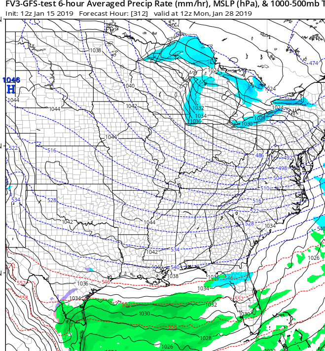
Frustrating to say the least though As it seems with every single wedge this year there is one piece missing or something isn't timed right.....and with this one it's once again lack of dry/cold enough surface air. This despite a well place high and a respectably strong one...in the upper 1030s. Normally such a high with even "average" cold air means it's game on for cad country... but at the surface there just isn't much cold air to work with. It's pretty reflective of how bad this winter has been that even with high of that strength and position that we still can't even get something minor south of nc, with the exception of the higher elevations.
That said, It does seem somewhat likely to see at least a little freezing rain in the higher elevations (above 1000 feet elevation) from ne ga and the usual prime areas in far nw sc/western nc based on subfreezing temps just off the surface on pretty much every model.
mix to rain here would feel like hitting the lottery...