

Lookout
-
Posts
5,769 -
Joined
Content Type
Profiles
Blogs
Forums
American Weather
Media Demo
Store
Gallery
Posts posted by Lookout
-
-
1 hour ago, NorthHillsWx said:
0.62” of beautiful glorious rain. Sitting at 79 with nearby anvils continuing to provide overcast. Been in the 70’s for 2 hours now in the middle of the afternoon on the hottest day of the year I’ll take it! Had to get lucky one of these days. Also brings me up over an inch for the month, lol
Finally picked up around a half inch yesterday myself..sure needed it. But more impressive i think is it has stayed in the 80s here today...only got to 87. I'll definitely take that.
What i wouldn't take is the absurd HI values in the mid atlantic today. Looks like there could be Some legit 120 plus values around chesapeake bay. Highest i saw so far was 127...based on surrounding observations it looks possible as many locations show dewpoints in the low to mid 80s. Yuck.
-
94 with dead grass and dust.
-
1 hour ago, scwxfan said:
Enhanced??? We got slammed last night with only a slight probability.
Even though the worst of the storms just missed here, still got hit pretty hard with 40 mph gusts and about 0.35 of rain in a few minutes time. Wasn't as strong as the other day but happening at night makes it seem worse. Considering the daytime heating being added to the mix as opposed to getting hit at 2 in the morning, would expect it could get quite breezy with some of these. I always worry about storms coming in from the north or northwest here since there is a lot of open space in that direction which allows the wind to get quite high.
-
Just got the power back on after getting blasted. Number of trees down or damaged around the area after easily 50 to 60 mph winds and white out conditions. Was a bit nerve racking for a while. Not surprisingly ffc didnt issue a warning when it damn well should have...meanwhile gsp was on the ball as usual and smartly issued a warning for elbert county.
Picked up another inch of rain.
-
Picked up 2 inches today in a couple of good storms. One of which had some of the largest raindrops i think i've ever seen. Legit sounded like hail but it wasn't. Gives me around 7 inches the past 10 days.
-
1 hour ago, LithiaWx said:
Low 40s in north GA this morning (Blairsville hit 43). My location just west of Atlanta went down to 52.
52 here too....was quite cool.. Little late but Wed the temp was stuck in the low 60s all day thanks to the rain. After the rain, the view today has been stunning...with crystal blue skies and everything turned green. Sure wish it was like this all summer.
-
 1
1
-
-
picked up around 4.20 so far with maybe a little more today. Probably not as much as a lot of locations just to the north, west, and southwest of here but glad to get it....it was very much needed.
Now looking forward to the cool weather....if there is some rain around wed, temps could be quite low in damming areas. Depending on the run, nam/fv3 showing temps only in the upper 50s to low 60s wed afternoon. Indeed wetbulbs are in the 50s. That's freaking awesome for mid june. Sure as hell beats upper 90s in may.-
1
-
-
35 minutes ago, griteater said:
The trajectory of the training cells here traveling south to north and NNW, and banking up against the Blue Ridge looks rather ominous for heavy rains and localized to regional flash flooding. Precipitable water / moisture content is high. Focus of the heavy rain threat looks to extend thru Sunday night.
From latest Excessive Rainfall Discussion from WPC:
PWs and instability will be on the increase again during the day and expect multiple rounds/clusters of storms through the period as additional shortwave impulses rotate around the mid/upper level trough to the west. A nearly stationary west to east boundary should help focus activity and support periodic backbuilding/training. The location of the main boundary appears to be a bit further south by later today...likely in the vicinity of central and western NC/SC. By later this afternoon into tonight we also will see an increase in 850mb southeasterly flow, which should add an orographic component to the rainfall along/east of the southern Appalachians across northeast GA into western NC/SC. The combination of the frontal boundary and increased upslope flow with time, suggests the likelihood of pockets of heavy rainfall into tonight. Would expect flash flooding to become increasingly common with time as soils saturate...and the setup does suggests the potential for at least localized significant flash flooding. The highest threat this morning is across western NC into southwestVA...and shifts southward a bit later today into tonight, with the greatest focus expected to be from far northeast GA into western SC/NC. This event does have the potential to produce high end flash flooding, especially by later today into tonight from northeast GA into the western Carolinas...and so will need to closely monitor trends across this region.

Just had a heavy downpour with only 30 to 35dbz....so these showers/storms are efficient rain producers. Nam and rap showing pws maybe as high as 2.15 over the next 48 hours. Considering what the radar looks like now with quite a bit of training already, one can easily see how flash flooding could quickly become a problem over north ga into western nc. Already 1 to 4 inches of rain with a lot of back building to the south/southwest in the atlanta/gainesvlle/athens region.
Finally got a good storm/rain yesterday...around 2 inches in 30 minutes. The rain rates were very high so there was a lot of runoff which was something to see after being so bone dry for so long...but what was even more amazing about it was seeing how fast the ground soaked it up. Not sure i've ever seen so much water disappear so fast. So that will help for a little while.
-
3
-
-
On 5/31/2019 at 5:35 PM, scwxfan said:
Me too. We just avoided triple digits here. But a nasty string of 96-98 degree highs. Still very dry.
Same here...was generally between 97 to 99 but never 100 so euro was a few degrees too warm....but certainly that was bad enough. Soooooo glad that hellish pattern finally has changed. Its bone dry here...indeed on the line of moderate drought....seems likely most get enough rain to change the course over the next few weeks...thankfully avoiding conditions getting worse. Hate to think what this summer would be like if we maintained that pattern.
-
2
-
-
On 5/22/2019 at 3:20 PM, Brick Tamland said:
Well, guess we are in the boring part of the year with regards to weather here. Looking forward to going to the beach, lake, and amusement parks this summer. But have to hang out at the midwest forum to get my severe weather fix.
Yep...not a lot to say when it's hot and dry day after day.
This much heat this early is depressing as hell. The only positive is that if its going to be hot it might as well be record setting. Although ffc isn't forecasting 100 here, I expect I will. Euro has been showing 100 here for days....last night run is still showing 100 here from sat through Thursday. Ridiculous.
-
As a fan of cosmology/astronomy since I was a kid, this is about as cool as it gets. First pic of a black hole.

-
1
-
-
39 minutes ago, mackerel_sky said:
Sunny and dry in Simpsonville! Fitting end to a craptastic winter! Not a flurry or sprinkle
I got 5 sprinkles around 5 am this morning and that's it. This after several runs of most models showing at least 0.25...with some showing 0.40 liquid or more here (0.90 on the nam) , multiple runs of the nam showing several "inches", as well as several runs of the fv3...and euro showing at least a little something. I had a bad feeling yesterday when the hrrr showed the precip shield also well east of where every other model hand it. It figures that since 9 out of 10 systems trend nw, this one would be the one to trend east since that would be the best chance of assuring a screwjob here. This is why i was super cautious about my chances here because naturally the winter hadn't sucked enough. Someone had to get one last big F.U. in.
Congrats to those who got some though. Non mountain April snow is pretty crazy, especially in sc.
-
 1
1
-
-
24 minutes ago, olafminesaw said:
The 18z Nam dewpoint is running 10 degrees above actuals for this afternoon in the triad
Yeah this is something i've been watching all day. Temps are about right where they should be but the dewpoints are quite a bit lower than just about every model by a good 10 degrees to as much as 14 in a few spots. If this holds it could mean there could be a bit quicker changeover. This has more impact on ne ga than sc since the models have the changeover happening pretty fast there where as it changes over slower here.
-
40 minutes ago, mackerel_sky said:
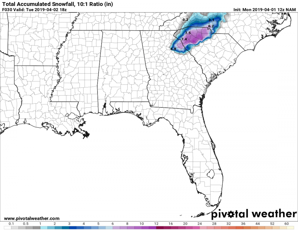
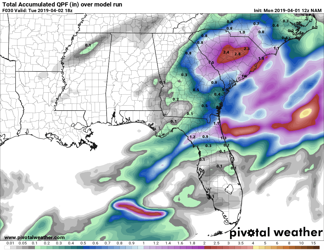
That NAM tho! It’s ok to be in the bullseye of 7” inside of 12 hours, right??
yeah, wish i could believe it...nam shows around 5 or 6 inches here. Although the nam has a reputation of being too wet it's had somewhat of a dry bias this winter. Given the lack of model support for so much, looks like it very well could be back to it's old tricks. The second wettest model, euro, shows 0.60 along and southeast of greenwood to rock hill. It's a clear outlier right now.
-
nam holds firm on it's much wetter solution. As high as 1.25 to 1.50 down near greenwood...just shy of an inch here liquid....0.85 to 0.90
-
 1
1
-
-
1 hour ago, mackerel_sky said:
That is very bold for them, and in April! The 0z Euro, and EPS = amazeballs!!
Unless there is a last minute nw shift, I would think any significant snowfall would be south of 85, not north due to lack of overall precip..not to mention that some will be needed to cool surface temps/column. Models seem pretty unanimous that the best liquid totals and best chances are south of 85.
1 hour ago, calculus1 said:The 06Z 12Z NAM was very friendly to upstate SC with a 7-inch lollipop of snowfall. We now have a HWO for up to one-half-inch of snowfall tomorrow morning. Crazy, but lovin' it!
Sent from my moto e5 supra using Tapatalk
Hard to believe, especially since surface temps start off so warm...in the low to mid 40s. In fact the nam shows temps as warm as 46/47 as late as 06z . Using a sounding in the heart of the heaviest area of progged snow on the nam in the upstate, At 06z, Wetbulb temps at the surface start off only as low as around 37 and wetbulb zero heights are between 925 and 950mb. So we are talking about needing some serious cooling to get some snow....much less significant accumulation. Gfs/fv3 are more reasonable showing temps in the upper 30s to low 40s at 06z.
For my neck of the woods, there isn't much difference temp wise at the surface or aloft than sc so i would expect it's possible to see some flakes at some point here too if these projections are correct but i'm skeptical of actual accumulations..outside of a brief dusting or something. That said, i'm personally rooting for the fv3

Seeing any snow at all in april would be pretty ridiculous though.
1 hour ago, PackGrad05 said:I hope this trends east so Raleigh can cash in a little!
Looks pretty doubtful. Temps look way too warm aloft. Besides temps aloft, the further one east goes the more they will be fighting solar insolation and it's brutal this time of year.
49 minutes ago, burrel2 said:I've got a feeling this storm is going to surprise someone. Setup is absolutely perfect. Thermals look great for upstate SC. Just need the blossoming precip shield to be a tick farther north than some models show. As it stands now, it looks like Mack's house over towards Charlotte could jackpot with 3 or 4 hours of moderate to heavy snow tomorrow morning. I wouldn't be surprised if a band in this area picks up a quick 3 or 4 inches, imo.
I'm skeptical most has a chance to get that much...i'm thinking at most an inch....maybe 2 is the general safe bet for max totals. Nam seems out to lunch with it's excessive liquid totals with most models only showing half that much or even less and some will be needed to cool surface temps too.
The irony though that we could get snow, much less accumulation, in freaking april after we couldn't get a damn thing all winter. Someone has a sense of humor.
-
23 minutes ago, Cheeznado said:
Flizzard in Atlanta!!! At least it will not be 100% snow free....
lol.....yeah. shame the temp isn't colder though, only 37. Won't complain though since i had low expectations of being missed completely.
-
flurries just started here.
-
1
-
 1
1
-
-
1 hour ago, FallsLake said:
NE parts of NE SC and SE NC just might see a surprise event. Even a dusting would be a win.
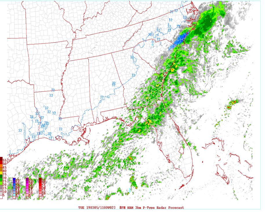
yep, also think the same could happen here in ga..especially between columbus to macon north/south of atlanta/athens. Models have consistently shown it cold enough on the northern fridge/back edge for snow. Surface temps are initially an issue the further east you go but temps fall to near freezing early south of atlanta so a light dusting isn't out of the question in these areas. It's the long range hrrr so take it with a grain of salt but latest says maybe a little more than just a dusting in a tiny area..several hours of light snow between atlanta and macon with temps at or below freezing and a narrow band of more than 0.10 liquid. Temps start out already near freezing when it begins too.
Would be nice if the models have been underestimating precip all along. The other day where we had a long line of showers/rain training over the same area for quite a distance (across the entire state) and not a single model picked up on it, including all the high resolution ones (didn't even show up on the simulated composite radar). Was thinking at the time, why can't this ever happen when it's cold. Would be nice if they missed this one by that much.
26 minutes ago, wake4est said:If a single flake falls here in SW Wake County it will be the most snow have had all season.
this would keep the winter for being a total shutout for a lot of folks.
-
2
-
-
gfs is a bit wetter than previous runs for everyone..especially carolinas where i'd say it's a lot wetter. previous runs had little to none, now has a few tenths.
-
Just now, Solak said:
Allan Huffman @RaleighWx 15m15 minutes ago
12z NAM-3km showing a period of snow Tuesday morning in interior SE NC. I dont expect any accumulation outside of MAYBE a dusting on elevated surface/grassy areas.
I'm watching this for my self to see if i can get a handful of flakes if i'm lucky as the trend has been for the precip to be a little further north here in ga. But knowing the way this winter has gone, the more painful runs that keep the band of precip just a county or two to the south will probably be the ones that verify. (euro) Icon has come a little further north this morning though, as well as the wrf suite. Probably my last shot at seeing anything this year unless something strange happens. If i manage to get more than a few minutes of rain/snow mix at 36 then this will be the highlight of the winter here.


-
5 hours ago, tarheelwx said:
It has been stated many, many times on this board that "CAD Always Overperforms" and the models always play catch up. I never really agreed with this as I know there have been many, many instances where we were borderline and nothing happened, or the event just didn't impress or even live up to some of the models. Today's storm was a perfect example - most places struggled to get down to the temp that the models were forecasting and this ended up being a nuisance event at best. Sure the sleet and snow on the front end was a bit better than expected, but that wasn't really related to CAD.
I think what this boils down to is that people tend to remember the really great CAD storms that overperform, but those that come up short are lost in our memory forever. It's kind of like a great game that is won on a last second shot involving 2 great teams, vs. a game between 2 decent teams where the final result is 5-10 points.
Feel free to chime in on this. I wasn't sure wherre to put it so mods feel free to place it elsewhere.
TW
.Not every cad event over performs but in general temps do normally bottom out a little lower than advertised and it breaks down slower than advertised. However it seems most people seem to judge a cad event solely on the basis of whether people reach 32/get freezing/frozen precip or not. In reality, We have a lot of cad events where we are in fact colder and for longer but few people pay attention if there is no real threat for frozen/freezing precip. But also it might seem like there are less surprises because frankly the models are able to forecast these events better than they used to be.
Dry air/low dewpoints/wetbulbs are still a problem for the models but this year and the past few really, there has been a lack of any real dry/cold air with these events, including this one..where temps soared into the 40s in va/nc yesterday and little in the way of dry air or really cold air off the surface to make up for it. We also have had more cases of cold air not being established before the moisture and it's always hard to over perform if that is the case. But the lack of dry air with recent events certainly seems to be a change vs the past....quite often with these wedges wetbulbs would be below freezing...but recently, and certainly this year, that hasn't been the case. Sort of hard to over perform with freezing/frozen precip when wetbulbs never or barely get below freezing.
-
1
-
-
5 hours ago, Queencitywx said:
This event overperformed, IMO.
yeah it over performed alright, had tons of lightning and heavy rain yesterday...far more than the relatively light amounts the models were showing. great times.


-
29 minutes ago, jjwxman said:
Current analysis now shows a 1040mb center of HP over OH/PA state line. Let's see what happens this afternoon in regards to temps/dewpoints.
I really can't get over a 1040/1041mb high in perfect position and we still can't get anything worthwhile in ga/sc.


July 2019 OBS
in Southeastern States
Posted
That's really cool....and they occurred only 7 hours apart.
CLIMATE REPORT
NATIONAL WEATHER SERVICE NEWPORT/MOREHEAD CITY NC
134 AM EDT TUE JUL 30 2019


...................................

...THE CAPE HATTERAS NC CLIMATE SUMMARY FOR JULY 29 2019...

CLIMATE NORMAL PERIOD 1981 TO 2010
CLIMATE RECORD PERIOD 1874 TO 2019


WEATHER ITEM   OBSERVED TIME   RECORD YEAR NORMAL DEPARTURE LAST
                VALUE   (LST)  VALUE       VALUE  FROM      YEAR
                                                  NORMAL
..................................................................
TEMPERATURE (F)
 YESTERDAY
  MAXIMUM         90R   106 PM  90    2011  85      5       84
                                      1993
                                      1941
  MINIMUM         65R   516 AM  65    1992  74     -9       74
                                      1957
  AVERAGE         78                        79     -1       79