

Lookout
-
Posts
5,769 -
Joined
Content Type
Profiles
Blogs
Forums
American Weather
Media Demo
Store
Gallery
Posts posted by Lookout
-
-
24 minutes ago, SnowDawg said:
Yep, 850's and 925's both looked great throughout. No warm nose at all.
Yep, only a very shallow warm layer near the surface which would easily be overcome taking it at face value.
22 minutes ago, Extreme NEGA said:Yep the suface temps is what I was referring to but that is true about last weekends system. Nice to finally have something on on the euro too.
It actually is a few degrees colder at 925mb to the surface than Saturday's system. Euro showing 0.50 to 0.75 liquid so those snow total maps are a bit underdone...probably closer to 4 to 6.
-
 1
1
-
-
12 minutes ago, Extreme NEGA said:
Soundings don't look good though
Just for fun given the time range but Soundings are fine from what I see. Its surface temps are obviously too warm given the snowfall. Keep in mind the euro busted pretty bad with the weekend snow...ended up being 5 to 8 degrees too warm at the surface.
-
2
-
-
35 minutes ago, Orangeburgwx said:
Meanwhile on the GEFS... NADA

Sent from my LML212VL using Tapatalk
If I recall correctly they didnt show any of the weekend snow either until shortly before.
We have a long ways to go but hopefully it works out. Have to believe this will be most folks last chance.
1 minute ago, frazdaddy said:Probably better that the GFS is not showing it yet.
Considering how rare it is for the gfs to even be close to right on anything at this range, much less snow chances this is probably true.
-
3
-
 1
1
-
-
1 hour ago, WeatherHawk said:
yes, just a bit
It's been Pretty ridiculous. Already have 0.30 with this first band...and based on upstream totals more than inch seems likely tonight. Which isnt huge news if not for the fact that most of the guidance was further north. Hrrr had my location getting less than 0.10 tonight. Not a good few days for the hrrr.
-
2
-
-
14 hours ago, ATLMet84 said:
Lookout, I've been on these boards for years and always look forward to your contributions. Did you at least see anything accumulate? I read through these pages and don't see anything about you.
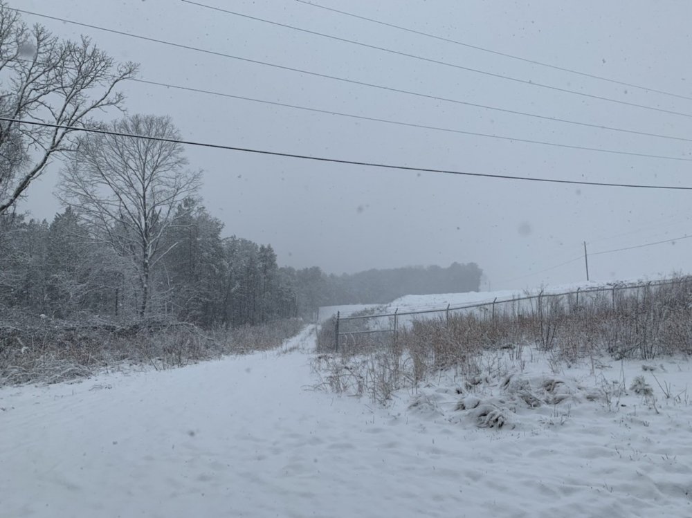
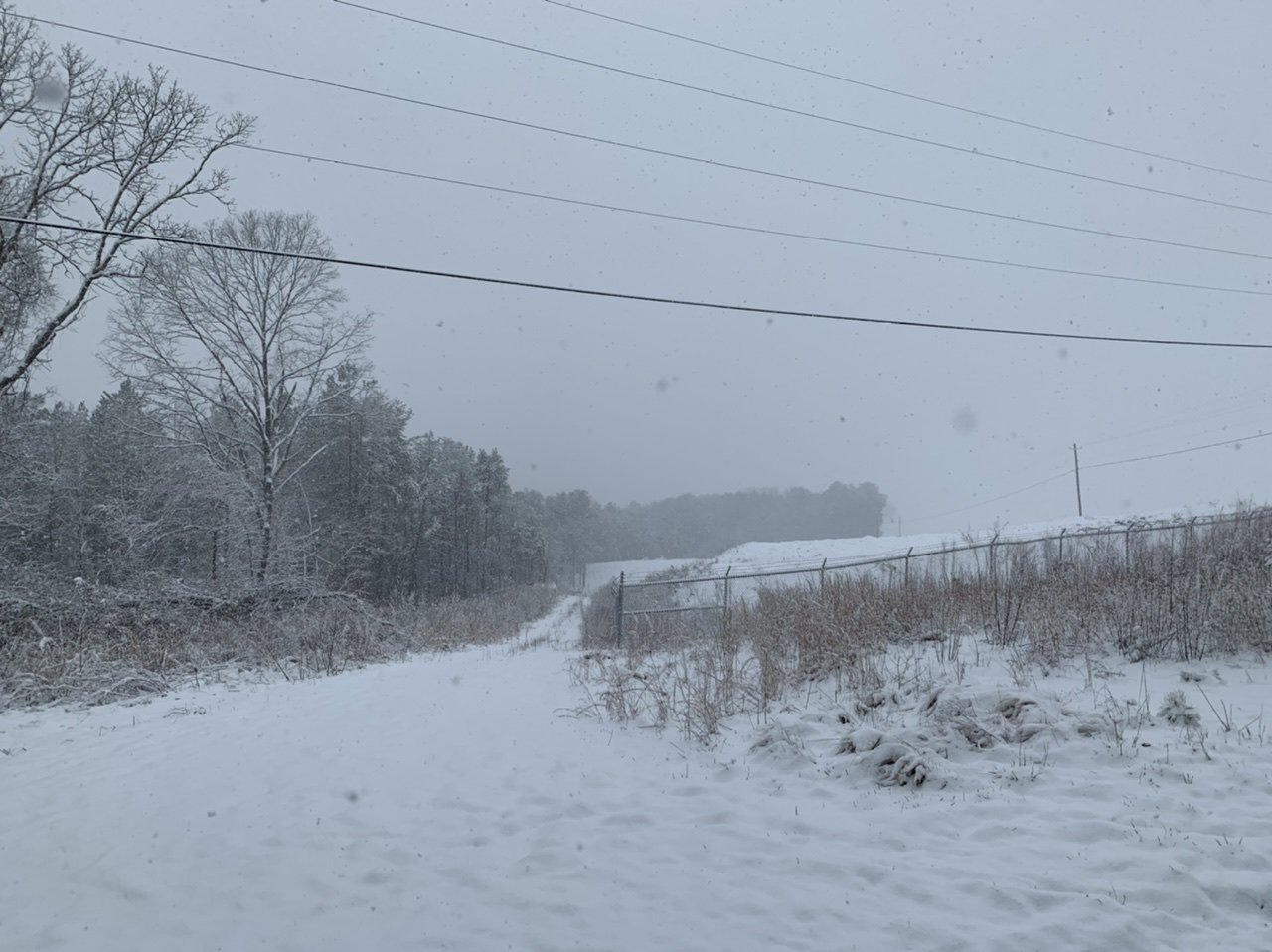
Thanks..yeah I got.about an inch..maybe briefly 1.25 in sun protected spots. I was hurt by the later start time and it was 36 when it started. If not for that probably would have had 2.5 to 3 like areas just nw of athens. It was all gone by mid to late afternoon.
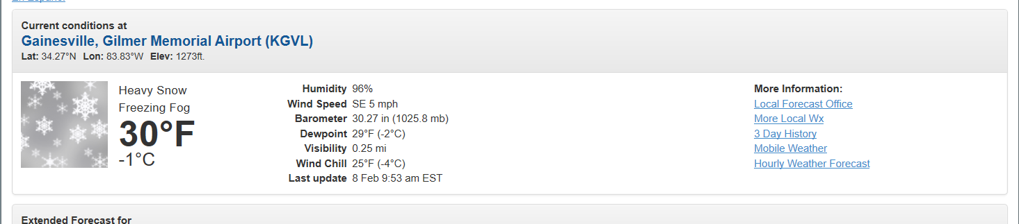
Had a light glaze on things from the freezing fog this morning...which was cool too after a low of 30. Probably going to be another big temp bust for the models. Hrrr and gfs Had been showing temps of 50 to 51 for a high but Still only 34 with thick fog where as of 11am where the hrrr has it at 41 already. . I dont think we will reach 53 ffc is forecasting.
Also 2.3 earthquake this morning in gwinnett county. Wild run of events.
-
55 minutes ago, griteater said:
Yeah I thought the 3km NAM did the best overall with this one.
Nice video here of flying locusts from Mike Seidel
Lmao...awesome.
-
Just now, SnowDawg said:
My favorite part of all of this is that a little over a week ago I officially threw in the towel on this winter and gave up hope. Then in an 8 day stretch most of my county has now hit seasonal average. Now if it'd just stop raining...
Yeah I think just about everyone was ready to throw in the towel. I knew I didn't have much hope left.
Ffc and gsp mentioning the chance for freezing fog tonight...would be neat if it's enough to make it white again.
-
11 minutes ago, SnowDawg said:
And that's 4-5 inches when 12 hours ago my forecast was for 0 inches and mostly rain. So, well done GSP, really prepared the public well for this one. I'd understand if the guidance was split yesterday. But by the 12z suite at the latest and probably even earlier, the models were absolutely locked in on what was going to happen here over North GA. I truly don't get how they missed it that bad at just a 12 hour lead time.
I'm surprised gsp got caught with their pants down to this degree...since as you said the models were all in good agreement for that area for a while.
9 minutes ago, burrel2 said:About the time Pickens and Oconee counties were at 2 inches on the ground they issued a WWA... these counties wound up with 3-5 inches and no upgrade to a WSW.
I don't believe NWS GSP predicts the weather anymore. They just issue advisories and warnings as the criteria is met, and half the time they don't even do that!
Did a bunch of folks from ffc move there or something recently?
But all kidding aside, aside from thinking athens should have been in the advisory sooner, i think ffc did a pretty good job overall.They did better than gsp it would seem.
-
3
-
-
8 minutes ago, NEGa said:
It’s down to flurries here now. What a storm though lol. This was by far one of the best the last couple of years at least. And it was during the day and a lot of us saw snow. The total here is 5.25” unbelievable!
Impressive to say the least. Imagine if someone had told you that you would get that much a week ago or even a couple of days ago lol.
2 minutes ago, NEGa said:It was snowing pretty hard almost to the end. And this was during prime time viewing lol
Getting that type of snow during the day time is pretty rare stuff that is for sure. So many things about this system and the before and after that i can think of that are unique and makes it stand out.To think that this much fell in what has been an insanely warm winter is pretty damn crazy.
As pretty as it is, can't help but wonder how much i would have gotten if this had come in just a few hours sooner here. OTHO, if it had been just a few hours slower it would have been all rain. Indeed, 20 miles south of here, it looks like it was mostly rain. Got some light sleety stuff now before it ends so i guess technically i can't say it was all snow from start to finish but close enough.
5 minutes ago, oconeexman said:Just measured in 3 places around deck and porch..solid 4" here and still steady!!!
Nice to see you do so well. I was just looking at some of the old model runs from a week ago and it's pretty wild. As rather fluckish as it was, it gives me a little hope that maybe we can get lucky one more time before it's too late. Have a feeling the carolinas will get one before it's over.
-
1
-
-
4 minutes ago, jrips27 said:
Looks a lot like my friends pics in gainesville. she got hammered. She probably had at least 5 from the looks of it.
-
1
-
-
6 minutes ago, oconeexman said:
It's back to dumping quarters again..headed toward 4"
Best snowfall in years from a weak wave...lol
It's all about timing
Considering the overall unfavorable indexes, no wedge, and how it essentially blew up right over ga/western sc and then quickly dies...this was quite an unusual event. And on top of that it occurred between two heavy rain/flooding events. Crazy few weeks of weather
6 minutes ago, chapelhillwx said:Ended up with about 2.5” in Woodstock GA, now melting rapidly. This is from just a bit further north in Canton/Ball Ground near the Cherokee county airport at 11am.
Yep, here comes the depressing part....seeing it all quickly melt away

-
2
-
-
4 minutes ago, ST21 said:
Got around 2.5-3 inches here in Jackson county, GA. Coming to an end soon, but what a nice surprise. All snow from start to finish, and beat the "up to 1 inch" prediction.
Never got a drop of rain here either.
3 minutes ago, oconeexman said:3km Nam was money for here on this one!
Even it under performed..it had me either right on the transition line or rain depending on the run. It did best with temps though, as well as a couple of the wrf runs. Looks like the rain/snow line was from washington to monroe or conyers here in georgia...about 30 miles south of where the nam put it...and i don't know, 75 on the hrrr lol
Nice to bust on the positive end for a damn change.
-
1
-
-
Just got back from a long and nice walk. Probably about an inch now but it's been pouring and still is. Temp 33.What hurt was it got to 36 before it started so a fair bit was wasted. Still, best day time snow i've had here in years...especially just from a scenery standpoint...with little to no wind and big flakes.
Certainly feel like it's over performed here considering every model showed all rain here verbatim and certainly no accumulation. What a fail for the hrrr though. Totally worthless precip type/temp wise. It had it getting as warm as 44 here.
-
3
-
1
-
-
3 minutes ago, NEGa said:
Hopefully your temp drops enough so it starts sticking! This one really blew up on in a day or so lol
Yep, its' amazing how our best snows or some of them usually pop up with only a day or two notice. also, this is all despite less than ideal indexes that everyone constantly obsesses over too.
It's ripping it right now... already a dusting. i can see why it quickly piled up to the north. Wish it started sooner but at least it's pouring.
-
13 minutes ago, NEGa said:
That is great! Hopefully y’all get into the action too
thanks...finally coming down good now. Been a while since i saw a good snow rate during the day here.
Friend in gainesville looks like she has close to 3 inches on her back deck as of a few minutes ago...she might push 5?
-
5 minutes ago, NEGa said:
I hope lookout is getting snow. My folks in Athens said it’s snowing pretty hard there right now. It isn’t sticking yet though
flurries just started here...must have been a hell of a dry pocket overhead as i've been under 20 to 30dbz for a half hour.
-
1 minute ago, NorthHillsWx said:
Wow

was just about to post that. Nice.
waiting is painful...but about to have 20 to 25dbz over me so that should do it.
-
the previous runs of the hrrr are running a whopping 5 to 8 degrees too warm where it's snowing now. It had gainesville at 38 right now on the 06z run.
-
1 minute ago, mackerel_sky said:
Where’s @LOOKOUT? Should be snowing there!?
lol it is above me...just virga right now. I'm guessing within 30 minutes it should be doing something.
Snowing and 30 degrees now at gainesville..nice to see those subfreezing temps materialize as expected there.
given how cold 925 to 975mb temps have been forecasted and the radar looks excellent, it's a bit surprising gsp hasn't been more bullish for the upstate. . 950mb temps as cold as -2c at gsp and freezing levels just off the surface. That should be more than cold enough to allow for some accumulation.
-
2
-
1
-
-
21 minutes ago, NEGa said:
Sooo wow what happened over night lol woke up to a winter storm warning, which I had not expected. Low clouds here and cold. This could be a fun day
I'm surprised gsp took so long honestly. Every indication has been there for a while for decent snow up your way.
Meanwhile been on pins and needles here. Have been torn on whether to drive north all night/day. It should snow here but the persistence of the models showing the transition zone one county north has been annoying...even though soundings would seem to indicated snow. Likewise i've been consistently on the border of the heavier amounts. Frustratingly saw sun, as expected this morning..indeed it seems my location has seen the only real breaks in cloud cover since sunrise
 .. but i have finally clouded over for good and temps only 34 currently after a cold 26 for a low. (8 degrees colder than the 0z nam and 6 colder than the hrrr) with a finger of precip starting to move/develop toward athens here. If it holds i should be into the heavier precip but just barely.
-
2
-
-
27 minutes ago, Iceagewhereartthou said:
I'm not too good with the short range models, but the HRRR has been consistant in showing the precip sharply turning to rain just as it hits the GA/SC state line and I am quite concerned about this. I really think the later arrival to SC is going to play a large role; plus, don't forget, that we often see a lee drying and warming coming from the higher terrain of NEGA. The WRF is much more bullish on upstate snow but I think that is a bias of that one. The HRRR, seems to be better with subtle temp changes, at least for the upstate. I seem to remember it correctly being the debbie downer before, but maybe I'm getting them mixed up. Someone was commenting about FOX21 going with cold rain for the upstate but that is probably the safest bet. There's certainly bust potential either way. It could easily surprise with a burst of snow tomorrow, but climo says it's probably mostly rain.
Yeah; death, taxes, and NC getting more than the upstate. I don't care what the set up is, if the upstate gets anything, WNC will aways, ALWAYS get more.
The hrrr is probably less bullish because of the hrrr warm bias at the surface..especially at longer range. For example, over north central ga despite moderate to maybe even heavy snow, it shows temps steady or even rising. Temps simply won't respond that way until the precip ends or lightens up considerably. Also, hrrr is bad about having too high of dewpoints....it's running 5 to 6 degrees too warm right now everywhere. So combination of that, cold low to mid levels, and big flakes falling...i'd urge caution on surface temps where precip falls. Also, for the upstate winds tomorrow should be light and variable or light south/southeast..so no downslope warming. (btw, don't be surprised if temps do reach close to 40 degrees ....even without downslope...it always seems to warm up faster than expected around here into the southern upstate especially). More Negatives is there is a chance of seeing some sun early on in eastern ga/upstate...and the potential for the precip to become lighter with time..especially upstate which would obviously mean warmer temps.
-
2
-
-
11 minutes ago, Snownado said:
Im skeptical about much in the way of accumulation outside the higher elevations in GA. Even Gainesville should be in the mid to upper 30s most of tomorrow.
I dont agree with this. Temps should be at or even below freezing around Gainesville for a good portion of the event. Temps will already be 32 to 34 at onset with wetbulbs around 30 12z to 14z..and with steady precip temps wont move much.
Take it with a grain of salt but its Interesting to note the hrrr and 3km nam have narrow areas as high as 0.40 to 0.45 on the 18z runs. Would be something if that planned out.
-
1
-
-
27 minutes ago, ATLMet84 said:
Well this is getting me excited then. What do you think about my area in NW Forsyth? I suppose it's mainly a timing thing (and enough precip), but if we get enough precip early enough, inch or so maybe?
You are in a good spot...probably one of the best outside the mountains as it seems the only question with your location is how much precip falls...as temps at the surface and aloft are plenty cold. Given the early start time where you are you should be at or below freezing for a good portion if it. I would think 1 to 2 inches is a good bet. If anyone outside the mountains do well it will be cumming, Gainesville, dawsonville, etc.
-
56 minutes ago, NEGa said:
Well I am watching. Most snows here, at least, are not modeled or forecasted a week in advance. They pop up a day or two away or come out of the blue. Fingers are crossed lol
Yep..its weird honestly how that is usually the case.
50 minutes ago, burrel2 said:Thermal profiles are all snow for the northern upstate. Boundary layer will make it difficult to stick. But if we get any appreciable precip I expect it to fall as snow tomorrow.
Models insist most of it is just north of here but I think its mostly snow as far south as here per soundings...assuming it doesnt arrive too late where surface temps are a problem. Hrrr as usual is too warm at the surface if there is as much precip as advertised. . Regardless it's close enough to drive too regardless. High resolution models showing some pretty decent returns on composite imagery some decent rates arent out of the question. Other than the mountains atlanta to Gainesville could be the winner as it arrives early enough for temps to be near freezing.
Could just the nam naming us but the 12z 12 and 3km run showing up to 0.30 liquid now.
-
1
-
Mid to Long Term Discussion 2020
in Southeastern States
Posted
Yep, if you buy the soundings on the gfs it still looks very similar to Saturday's snow...if not even a touch colder where I'm at...similar to the earlier euro runs.
Wish it wasn't still 6 days out and I could cash out now with the 18z gfs...0.70 to 1.00 liquid here..looks like all snow...save for maybe a little rain to start. It's hard not to be hopeful and encouraged but knowing how wrong the gfs normally is at this range..it worries me just as much.