

Lookout
-
Posts
5,769 -
Joined
Content Type
Profiles
Blogs
Forums
American Weather
Media Demo
Store
Gallery
Posts posted by Lookout
-
-
6 minutes ago, wake4est said:
^ Those might be the most visually unappealing weather maps I have ever seen
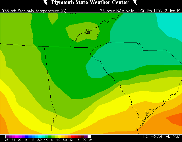
yep, pulled that from one of the original sites us old timers used. i used 1 degree intervals to show the extent of the -1c temps. Unfortunately it's not easy finding sources that show 950 and 975mb wetbulb maps.
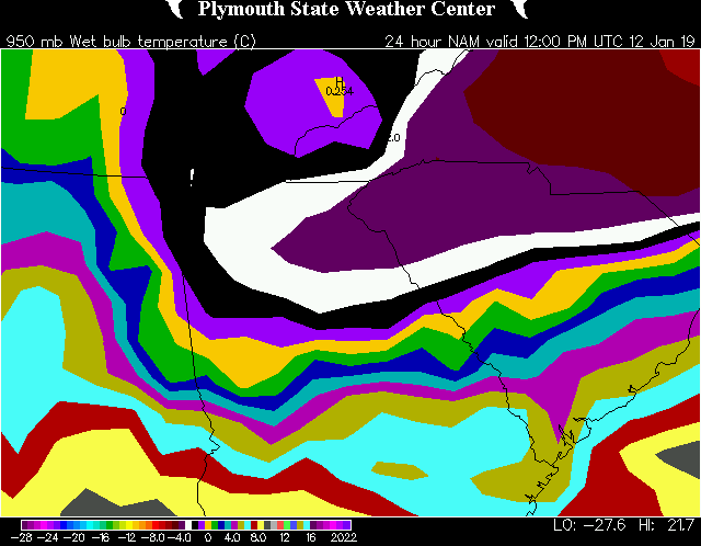
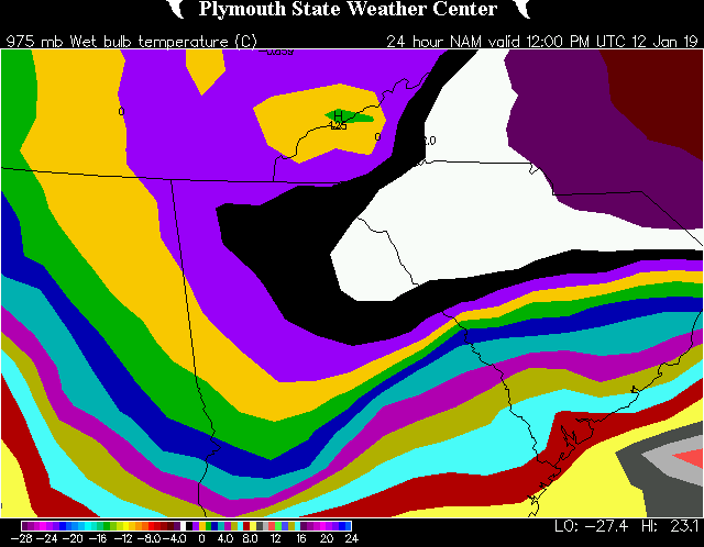
here it is with 2 degree intervals.

-
 1
1
-
-
1 hour ago, mackerel_sky said:
Is this a sleet sounding or just ZR?
Overnight, just freezing rain. Depth/degree of subfreezing air doesn't look deep enough for sleet and there is a huge warm nose.
46 minutes ago, NEGa said:I dont really know what to think at this point. This set up reminds me of one a while back where we ended up getting a ton of ice (the infamous "I hope you get an inch of ice" storm) when the forecast was a cold rain right up till the event started. After that over the years, a lot of times the set up seems to be there but for one reason or another we end up 33 or 34 and rain.
The higher resolution models are showing a pretty big CAD, and the high seems to be in a pretty good location. It won't take much for NE GA an the upstate to get some ice, however, without much support from the other models I am just not sold on it at this point
I don't think you will have to worry on this one. Looks like a lock for ice in your neck of the woods. I'm sold on everywhere north of 85 getting below freezing...in fact based on the nam/rgem, you should get into the upper 20s at your elevation. Also the nam has gainesville already at freezing by 18z.
South of 85 though is a tougher call. You are right that this has all the usual signs and bells for a 30/31 degree ice event for north ga but timing of the precip couldn't be worse. If it comes in a little earlier there'd be little doubt but thanks to late start time of the main precip, will have to see how warm these areas get tomorrow and what the dewpoints do. I can say one thing with confidence, toss the gfs. Total trash....despite showing dewpoint depressions of around 15 degrees, it shows no temp response. That's absurd based on the fact we have a pretty solid/thick and cold boundary layer. Ice or no ice, it will bust by at minimum of 5 degrees in a lot of places.
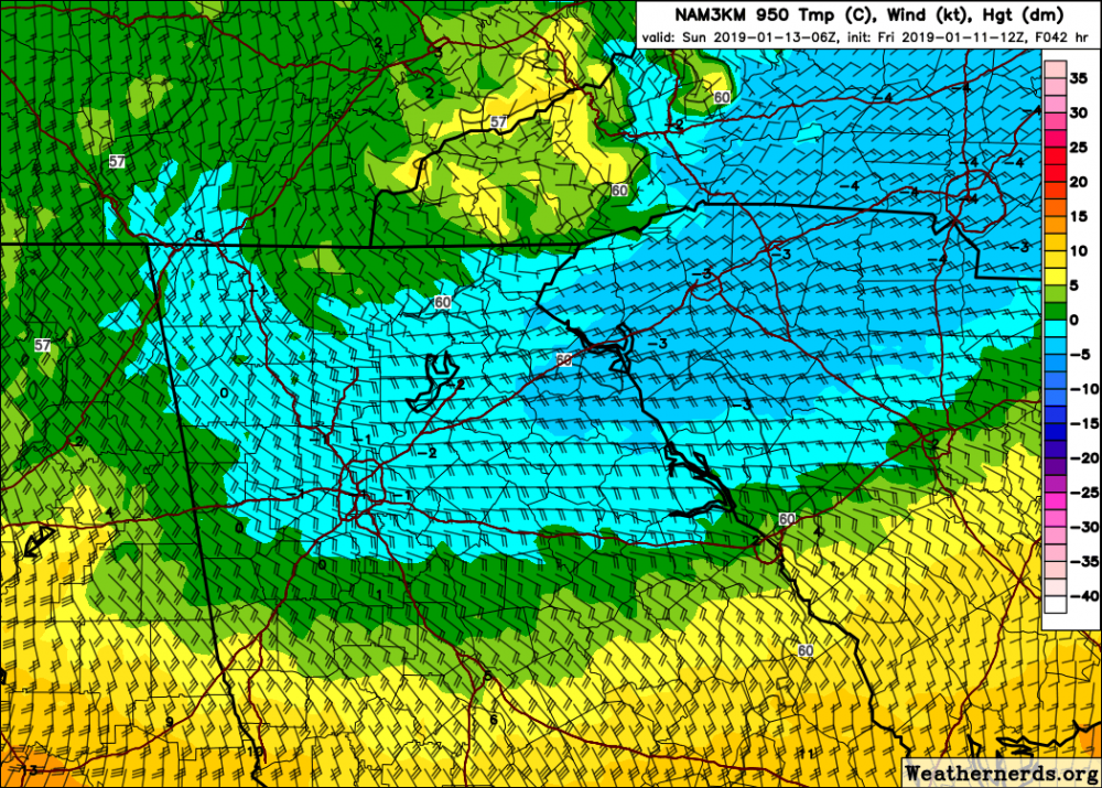
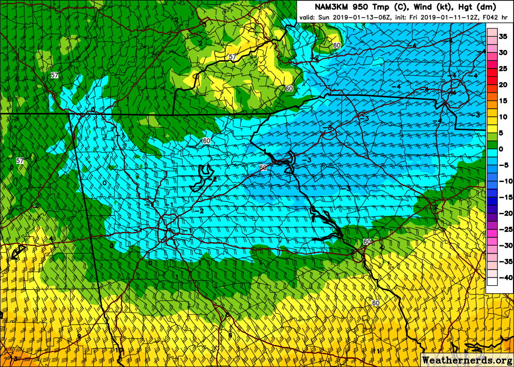
Here is the nams wetbulb temps i was speaking of earlier before any precip arrives. at 950mb/975. (actual temps are subfreezing too) this is fairly impressive with it's large extent. This look normally has ice written all over it assuming surface temps/DPs/wetbulbs corporate but we'll see.
-
1
-
-
5 minutes ago, mackerel_sky said:
That’s pretty deep into SC. Seems overdone. CMC and NAM seem on an island of their own!?
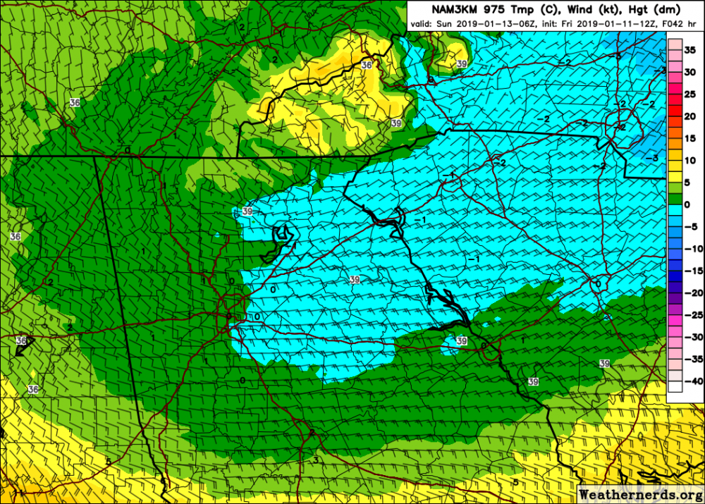
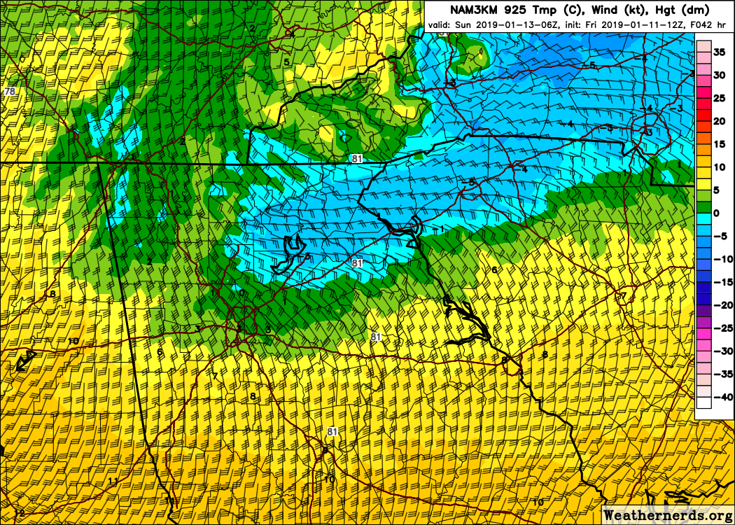
Just the opposite actually. I think temps get to below freezing over a pretty large area assuming temps don't get too warm saturday. But Here is the 3km nam's 925mb to 975mb temps... This is a pretty classic temp profile and look for ice for north ga/upstate...and even this might be a little underdone since wetbulbs at these levels start off around -3c.
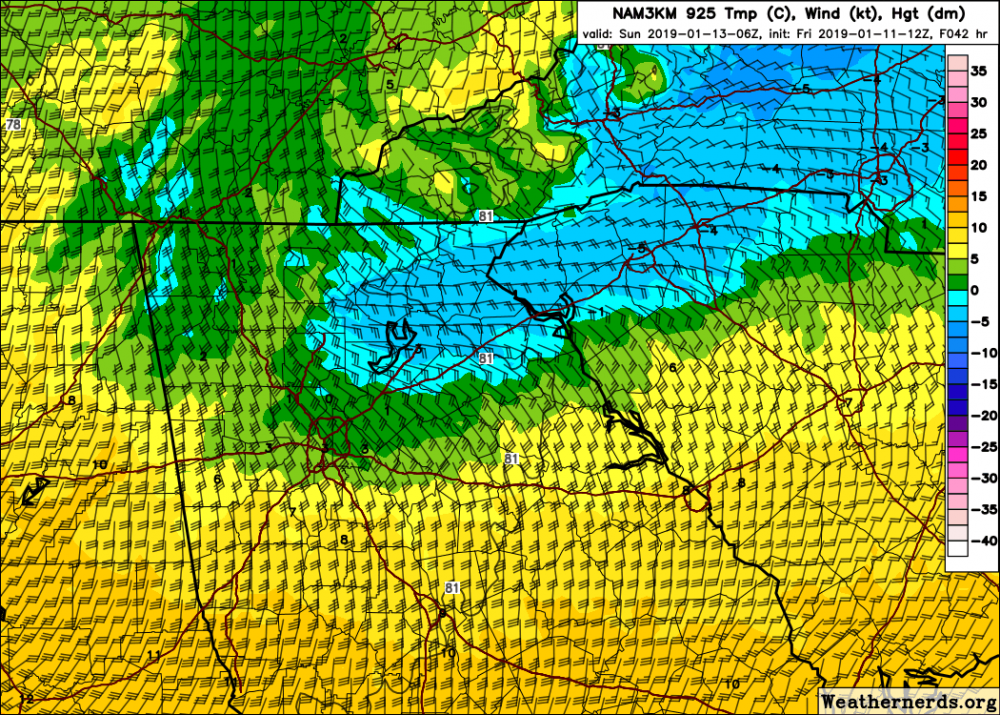
-
1
-
 1
1
-
-
31 minutes ago, Looking to the skies said:
I don't know how significant or any significance -- as far as the CAD but the low to my East this morning in NE Alabama was 19. The cold might be more entrenched than 1st thought?
The bottom dropped out here too, low of 22....even colder than surrounding areas. This is As much as 10 degrees colder than some guidance...but these calm clear nights with low dewpoints it's not unusual to see.
-
14 minutes ago, jjwxman said:
Geez, I'd take 33 and rain over the apocalyptic ice storm the CMC has. Drops 1.50-1.75" qpf over the I-85 corridor which remains below freezing for the event.
yeah the canadian is bad news honestly for everyone in cad territory with so much precip. Wetbulbs are in the upper 20s to near 30 right as precip arrives and the depth of the cold air is sufficient to keep it subfreezing for a good chunk of it,..through 925mb. Put simply the canadian looks like our classic ice storm for ga/sc./nc. Nothing like the december storm in terms of the setup...where in this case the cold air is already well established before any of the precip arrives. Of course it's the canadian so tonight it's likely to show something totally different but for this run at least, it looks slick.
-
8 minutes ago, BornAgain13 said:
Not 100% sure, but from what I can tell, 12z CMC is Miller A... tracks up the coast... very different from 12z GFS
yep, much further south. although they handle the low much different, both solutions look icy for many.
at least this system has one thing the last one didn't, actually respectably low dewpoints/dry air, and evap cooling potential.
-
52 minutes ago, Iceagewhereartthou said:
Yeah, not going to happen. Not sure about column temps but surface is 37 here. Looks like a pretty big batch so could be a few inches if all snow, but I think all its gonna do is wash away the little remaining snow.

Have some snow mixing in with the rain here currently and 36.5.....after a high of 42. Despite being totally saturated and having drizzle/heavy mist all day...Temp dropped 4 degrees in about an hour after the sun set and the precip that is originating upstairs actually started falling. Temps at 950mb to the surface are as marginal as they can get here so doubt it does any more than this before it ends but I think a full changeover is possible over toward greenwood/columbia since it's slightly colder there just off the ground per 3km nam and hrrr (if it lasts long enough). Been watching it all day but was scared to say anything out of jinxing it lol....sad.
-
2
-
-
Took a long time but getting first flakes here too...light rain/snow mix currently and 35. Radar isn't even showing returns over me at the moment.
-
3
-
-
12 minutes ago, oconeexman said:
I've actually seen it go both ways..sometimes itll lock in here and we will be 5-7 colder than GSP when it retreats. Then theres days like today when I'm at 40 and gsp is at 33. I guess it's where the high sets up shop. Those that are more Hudson babyish or more northern seem to be better for new sc. More east based toward Va seem to help gsp more..I guess.
I got to see about 6 hrs of awesome snow but surface temps never got below freezing last night. Then around 0230 the warmth took over and it was a sleet fest.
Fascinating. Never ceases to amaze me how the topography effects things around there/here. Sure makes it difficult to get a grasp on what to expect. I've often thought how nice it must be to be in the ohio valley or plains where it's a lot more straight forward.
7 minutes ago, PackGrad05 said:I would really love to see this happen tomorrow. We only got a couple inches of slush in southern Wake and most of it was over before sunrise.
Models are looking good. Upper level lows bring their own cold, so we have that going for us, too.
new hrrr is looking really promising, especially for south carollna where they got nothing. a bit colder and dropping a couple of tenths liquid With temps at 32/33.
-
2
-
1
-
-
24 minutes ago, oconeexman said:
Well I have slowly risen to 40 now..depressing
Yeah that sucks. How do you normally do when wedges break down? Do you warm up faster or slower than gsp/anderson?
Temp here has actually dropped back to 34 after getting to 35. Still have a 10mph or so ne wind with heavy mist/drizzle. Hard to see me rising 4 or 5 degrees overnight.
-
5 hours ago, burrel2 said:
Every model wasn't too cold for Charlotte if you don't base a model busting or verifying off the clown map predictions which honestly mean nothing in terms of what a model is actually showing.
For instance, some clown maps don't account for warm air above 850mb... some of them don't account for surface temps being above freezing...
As an example: If the GFS is showing a moderate snow sounding at noon with all layers below freezing except the surface temperature is 34 degree's for 3 hours. It's clown maps will show 3 inches of accumulations, but in reality there be 0 accumulation due to the 34 degree surface temperature and solar insolation.
If that verified exactly as the model predicted, there would be 0 accumulation, but Mack would be on here a few hours later crying about how terrible GFS did with his snowstorm.
Good post. I have No idea why anyone even looks at snow accumulation maps unless temps start below freezing and you know for sure everything will stick.
5 hours ago, burrel2 said:To talk further about this specific storm in charlotte. A lot of models were showing a possible "sleet" sounding, but in reality the low level cold pool may not have been deep enough to freeze the water droplets leading to plain rain. The skew-T could have been dead accurate by that models prediction, but the clown map/precip type map is not sophisticated enough to read a sounding and accurately describe would is falling from the sky with that sounding at every point location in the region.
So precip type map may show all of charlotte in the sleet color zone, when in reality it's simply raining there, but the model did not bust on it's analysis,(other than the precip type maps).
Over ne ga, the hrrr showed too much sleet. It showed gainesvlle getting 6 hours of it but in reality they only got a little bit during the heavier rates. And it showed sleet making down to here and unless there was a little in the heavier showers, i never saw any. It was pretty obvious it was in error as it showed the max temp above ground getting to near 40 at the time it was showing it and the warm layer was deep.
The fv3 over did the snow a bit a little bit but otherwise did an ok job as snow got down to cornelia and surrounding areas for an hour or two. Nam on the other hand failed to show it. Nam was too warm yesterday but in the end was about right as far as the lowest temps went. FV3 was actually a degree or two TOO cold.
1 hour ago, lilj4425 said:Yeah. I can’t wait for some cold rain.
 Just what we need...more rain.
lol...What makes it worse is the best chance is further to the south AND the rich will get richer as those who got a lot today will get even more. So that means there could be a zone that has been exceptionally screwed and tortured where they watched areas to the north get snow last night/this morning and then watch areas to the south get some tonight/tomorrow morning. In my case, I fear i'm going to be in a situation where it's snowing a couple of counties over while it's dry here. I'd be happy just seeing a little bit falling through the air but will be lucky to even get that.
-
20 minutes ago, Snow dog said:
Really hard for me to believe this map-snowing in the midlands while I get rain??
It looks like it. Across the board the models are colder from 925mb to the surface there. Essentially the models push the cold pool with the wedge to the south. Here is the nam's 925mb showing just that. Also here is the nam's 2 meter temps and as you can see, it has really warm temps over the ne corner/nw upstate. GFS is a few degrees colder and the hrrr is showing temps in the 32 to 34 range.
although the gfs/hrrr are colder at the surface, they all show warming above it similar to below. That said, If precip develops and it's sort of widespread, i wonder if that would make it a bit colder than they are showing. the 18z nam was wetter than the 12z and it was a bit colder as a result at 925mb at least. A bit unusual but they have consistently showed this.


-
1
-
-
picked up 3.25 inches of melted snow.
low was 32.7. Never expected anything here except at most maybe a tree top glaze but that was a degree warmer than i thought...in fact temps in general were a degree warmer across ga than i thought they'd get and probably 2 or 3 degrees warmer in the northern upstate...figured they'd get to 29 or 30.
Can't be said enough that dry air makes the difference but it also hurt that the band of precip that spread across ga and sc didn't fall in north carolina instead. If it had fell across nc, it would have allowed them to wetbulb down and keep them cold, and that air would have eventually made it's way south. Instead, they warmed up quite a bit saturday and the rest is history. But i don't think anyone should feel robbed out of an ice storm, if it had been a few degrees colder with these winds and amounts, it would have been a disaster.
-
1
-
-
59 minutes ago, Queencitywx said:
HRRR is further south than the Euro

Although there is some question about depth of the moisture, Models stubbornly warm the lowest levels over north ga/upstate overnight which is why some of that is shown as rain. despite northeasterly flow, which is a bit baffling to be honest. That said, some of the recent runs are a touch colder. Nam especially seems bizarre, showing temps rising into the upper 30s and even near 40 over the northwest upstate. There could be some weak downslope over far ne ga/nw upstate late but otherwise flow is remains NNE to NE throughout the low levels and if this happens it will surely be a first. I can't recall a single time where the temp starts above freezing already and rises several more degrees during the night with NE winds/flow so i'm curious how this shakes out. HRRR is much colder, especially in the upstate, showing temps staying right where they are now which seems like a no brainer. Models were pretty damn close with temps in the end here...got only to 32.7 here, which is a degree warmer than i thought it would get. So I can't totally discount it. Hopefully Places that were screwed and missed out will get a little something out of it.
I would expect i would see some here too but the hrrr is dangerously close to showing most of the precip missing here. naturally.
-
1 minute ago, NEGa said:
It did change quickly I was surprised. I saw the warm nose, but at least I am used to that in ga storms. Fortunately as long as it stays frozen its a good winter storm by my low standards lol. It’s pretty coming down for sure
Most of the time i end up being jealous of you and this one is no exception. The amount of sleet you could end up getting should be quite impressive....assuming the warm nose doesn't switch you over to freezing rain but it doesn't look like it will.
12 minutes ago, audioguy3107 said:The wind here is amazing....we’re probably getting gusts to 30 mph at this hour. I can tell you we’re honestly probably lucky the wedge isn’t quite as cold and dry as in previous storms because with the amount of qpf along with this wind, that would be one helluva ice storm and probably one for the ages.
For real....if it was and we had these high winds with it this much precip, people would be out of power for a week or more. The hell with that.
-
11 minutes ago, SnowDawg said:
A lot of what I thought was rain earlier was mainly sleet, may actually have an inch of that on top of the partially melted snow from earlier. Now it just keeps flipping constantly. At times it’s mainly snow, and then it’ll flip mainly sleet and mix in between the flips. Hoping to flip all snow before the heaviest gets hear in a couple hours. Still can’t get that dry easy wind that everyone else is getting though.
A couple of years ago i went to clayton for an event and it kept doing the same thing. Not much different from this setup in terms of thermal profiles. End up getting quite a lot in the end but the constant changeovers made me feel like we were robbed somewhat.
-
1
-
-
4 minutes ago, NEGa said:
Yep that’s sort of near me lol. It is all snow and just pouring down right now. Think the change over was about 915-930 to go to all snow
guess we will see how well the hrrr does here as it shows the 750mb warm nose screaming in changing it back over to mostly sleet in just 2 hours. Still, you should do well due to the high rates. Looks like via CC radar it's very close to changing over in gainesville too...wouldn't be surprised if they are seeing some sleet mixed in now....pretty amazing how fast that entire area switched over.
-
4 minutes ago, NEGa said:
Snowdawg are you back to sleet? Started a mix of sleet and snow a few min ago and the back deck is already getting crusty.
Models doing a fairly good job with that changeover as they generally showed it happening around 02 to 03z. Snowing in cornelia at the last observation too.
-
6 minutes ago, SnowDawg said:
Well still sitting right around 32 but inexplicably we have been at almost pure rain for over an hour now. Radar says snow but it’s not. Certainly didn’t expect this sort of warmth aloft yet. Desperately needing some dynamic cooling.
Interestingly many of the models hand a handle on this showing slightly warmer temps for a few hours in the mid levels before cooling back down.
Wind is really starting to howl out there now...gusting over 20 here...yucky 38.
-
18 minutes ago, NEGa said:
What a waste of precip - almost an inch lol. The dew point is starting to drop - at 34 now
yep but it's still on course. None of the models really had it changing over to snow outside of rabun county/higher elevations until or after sunset. Taken verbatim, the fv3 has it occuring between 0z and 03z based on 850mb temps. It shouldn't be long before the upstate changes over. When it happens, It will probably happen in a hurry too. If there is a concern, it's the latest hrrr is a bit warmer than all it's previous runs. It has done a good job on these transitions and precip type the last several storms so i pay close attention to it.
10 minutes ago, oconeexman said:Yea no doubt this fall has been uber wet..almost an inch now here as well..should easily exceed 2 inches or more of water
Could be some flooding issues...and thanks to very high winds power outages even without ice. FFC is forecasting 40 to 45mph gusts in athens and gainesville.
-
1
-
 1
1
-
-
22 minutes ago, broken024 said:
Nam 3k is damn close to all rain for north union...
hmm..not sure why but my last post went missing so here it is again.
I'll be honest, i'm having issues with the 3km nam. For starters, it's too warm at the surface. Second, i find it next to impossible to believe there won't be more sleet than it shows over northeast ga where it essentially has none. Never mind it is warmer than even the hrrr at the surface. Third, it seems too warm aloft compared to the hrrr. Here is the 12z 3km nam 6 hour 850mb temp vs the 0z analyzed hrrr at 18z...
.thumb.png.4f94580e5f9c92167a796d03bc832bc3.png)
-
1
-
-
9 minutes ago, broken024 said:
Nam 3k is damn close to all rain for north union...
I'll be honest, i'm having issues with the 3km nam. For starters, it's too warm at the surface. Second, i find it next to impossible to believe there won't be more sleet than it shows over northeast ga where it essentially has none. Never mind it is warmer than even the hrrr at the surface. Third, it seems too warm aloft compared to the hrrr. Here is the 12z 3km nam 6 hour 850mb temp vs the 0z analyzed hrrr at 18z. So imho, i'd be cautious about it right now imo.
The hrrr has done well in the past few winter storms here in ga so i'd put more weight on it right now.
.thumb.png.080789d75eb7b9d9a4079f50d30e8ac1.png)

-
3
-
-
Just now, SnowDawg said:
Steady mix now, elevated surfaces a bit slushy. Temps down to 34.9
Good deal. Looks like you are right on schedule for a monster.
-
1
-
-
fv3 still showing a changeover to very heavy snow for a few hours down to gainesville. Nam still says no and only shows a change to freezing rain toward sunrise. Hrrr still showing a changeover to heavy sleet. Going to be fascinating to see which model, the fv3 or nam, wins this one.
-
2
-

.png.2b3053f05d75218d844dc64e493640ce.png)

.png.a5ca87bce0368bfa07f221ef71c783c7.png)
January 12th-13th event
in Southeastern States
Posted
I think this is the first time i have ever heard or seen someone argue for the gfs in a cad event. If you are in zone of cad real estate in north carolina, you are making a terrible mistake hanging your hat on the gfs.
At any rate, the nam is also too warm...in some cases by 5 to 7 degrees with dewpoints. For example, the nam..including the 3km, has dewpoints of around 28/29 in the upstate..when in reality they are in the 20 to 22 range. Looks like it's off by around 5 degrees in north carolina.
On average, when there is actually some respectable dewpoint depressions and evaporation to be had...which the event in december did not have at all, , the average error rate is 1 to 3 degrees too warm after saturation...with the old gfs being upwards of 3 to 5 degrees.,especially on the edges.