

Lookout
-
Posts
5,769 -
Joined
Content Type
Profiles
Blogs
Forums
American Weather
Media Demo
Store
Gallery
Posts posted by Lookout
-
-
26 minutes ago, HKY_WX said:
Take a peak at the WRF. Brings 50 to 55k sustained winds through SC/NC. That's not including gusts lol. The SFC low starts to strengthen as it hits NC and becomes more extratropical in nature. This will be a WILD 24 hours. Buckle up SE folks. We're witnessing history today/tomorrow.
This hrrr map is one of the more unique maps i've seen...going to be a wall of high winds crossing the carolinas. Showing as high as 75 knots in places. crazy.
Saw quite a bit of sun here this afternoon..so tornado threat has certainly increased. Going to have to watch these storms over ga closely.

-
 2
2
-
-
19 minutes ago, downeastnc said:
Keeps 50-70 mph winds all the way through from SC to offshore NC as well and covers a large area with those winds to boot.....this is more believable to me than the GFS maps since the GFS had the pressure at 970 and winds around 90-100 at landfall, and well that was really off lol...the hard part for forecasters is to predict how the trough/ jet streak will interact with the strong circulation and low pressure of Mike....there is really no precedent for this in the analogs etc.....
There is excellent model agreement now. Every model has shown these winds increasing over nc/sc, including the wrf/hmon. The shear amount of real estate that could see 50 to 70mph wind gusts is incredible.
17 minutes ago, ryan1234 said:I'm curious to as to how strong winds will get for the Carolina's, especially along and east of I-85. Looks like you are going to get some pretty significant gusts as well. I'm in Union County, NC which is under a Tropical Storm Warning.
Right now, it seems likely to get 45 to 55 based on the hrrr/3km nam....but as downeast says, this forecasts are based on models that don't have a good handle on just how deep/strong michael is currently so it could be a bit higher but i hope not. HRRR is showing gusts of 70 to 80mph all the way into sc alone and based on the storm being 967mb now I really don't want the power to go out because if it does, it could be out a while.
-
12z euro has come north a little on the 12z run...in particular over the carolinas.
-
11 minutes ago, QC_Halo said:
Where’s Seidel? I bet he’s flat on his face about now...
How do you see Brett Adair love feed?
i've been wondering too...guess after that debacle they have him staying home. he would have been a huge distraction for sure. It's a shame he totally destroyed his reputation.
-
this station is gusting to 130mph
http://ds.weatherflow.com/storm/michael#29.968,-84.265,9,8,180980,1
-
nhc ups the winds to 150 923mb
-
2
-
-
14 minutes ago, jburns said:
This. I'm no Josh but I have been in quite a few canes. The best way I can describe it is although the measured wind velocity may be the same a strengthing cane feels much more violent. It swings wildly and very quickly from less wind to more. It is almost like taking repeated punches from a professional fighter(don't ask me how I know that). A weakening cane may have the same amount of variety in wind speed but it feels much more smoothed out. It raises and lowers much slower than a strengthing cane.
that is one of the more interesting descriptions i've ever heard about it... fascinating. thanks for that.
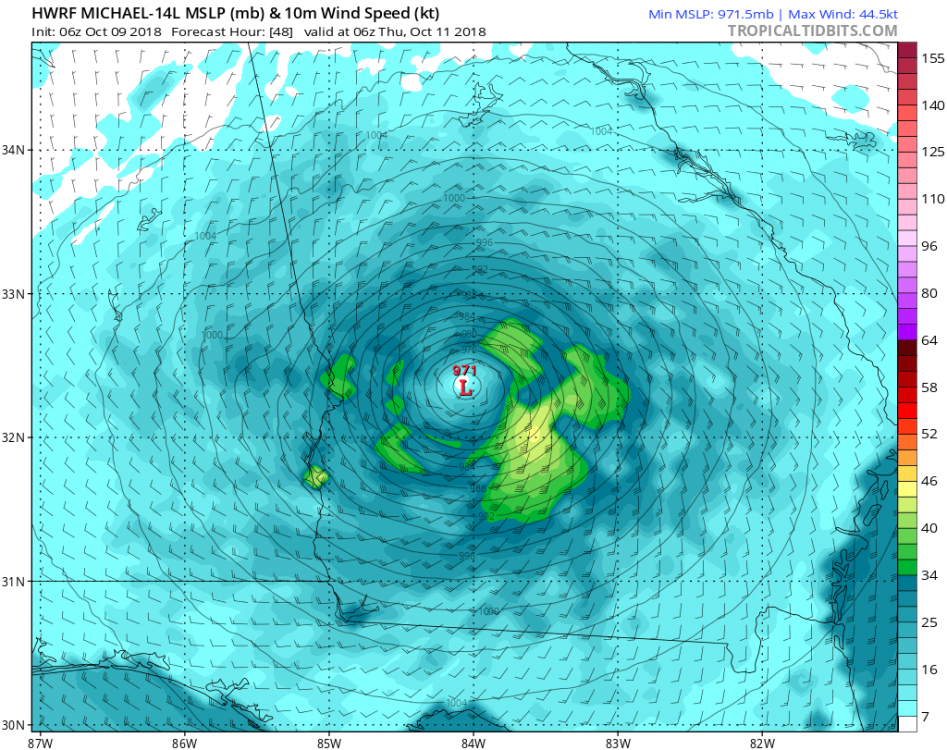
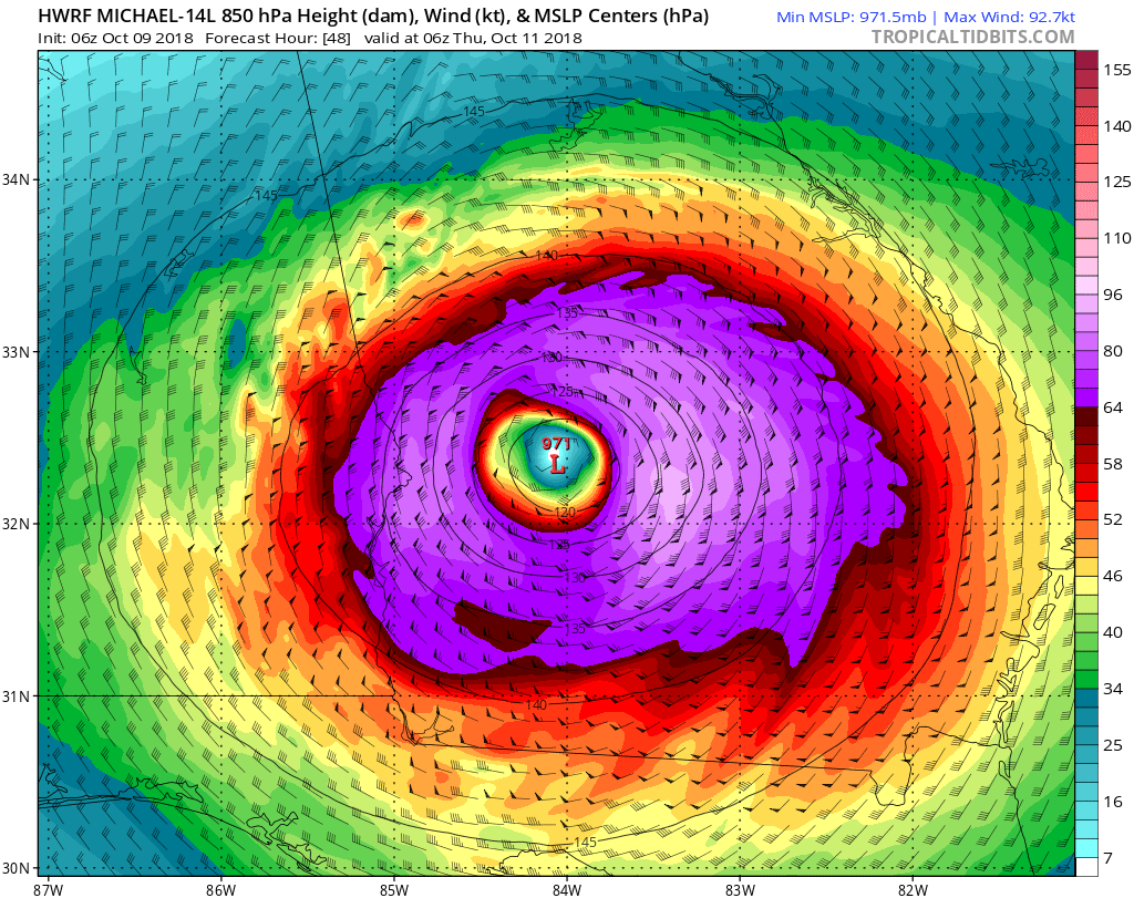
3 minutes ago, DopplerWx said:919 extrap. holy...
wow. hard to find the words...if it's not officially a cat 5 at landfall, that would almost seem unfair to michael.
-
Just now, downeastnc said:
Luckily it might not have time for the winds at the surface to catch up to the pressure falls, but what it does mean is the storm will take longer to start to weaken as it moves over land.....
yep, a big difference between a storm that is strengthening at landfall vs weakening. This is wild to me but nhc has it as still a 100mph hurricane as it enters southwest georgia. damn.
-
2
-
-
6 minutes ago, kvegas-wx said:
Agreed and understand. However, across central NC we usually see 25-35mph gusts from significant tropical systems that pass thru. So we get, 35-50 this time, big deal. It's still thunderstorm type activity which can lead to downed trees and power lines. That's really my point. The mets aren't going to freak out over conditions that could come from a spring frontal passage, a summer storm, or a decaying tropical system.
Regardless, be prepared!
I don't know, i understand not over hyping but widespread 55 to 65mph winds is a pretty big deal....never mind if it gusts to 70....especially considering how wet the ground is in nc. If there are winds that widespread, power outages could be quite widespread which means some could be without power for a while. Irma was a weak system technically when it impacted georgia yet the impacts were very high and some were without power for days....and for those without power for days it's a big deal.
FFCs discussion is ominous but not unexpected to most of us i'm sure.
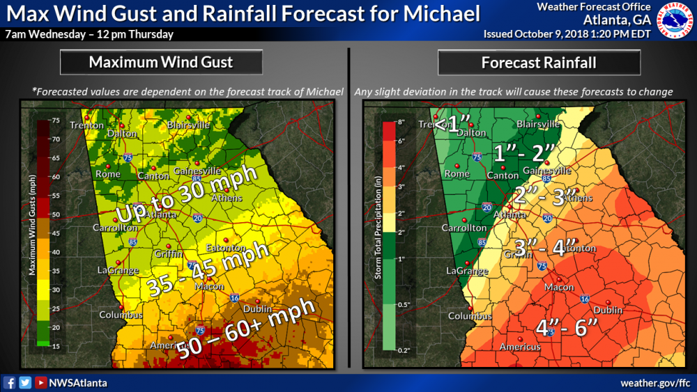
Area Forecast Discussion
National Weather Service Peachtree City GA
1033 AM EDT Wed Oct 10 2018

.UPDATE...

...Hurricane Conditions Becoming More Likely For Portions of
Central Georgia...

All attention is on powerful Hurricane Michael as it churns
rapidly toward the Florida coast as a Major Category 4 storm.
Concern for the local area is that the storm will now be starting
from a more intense initial condition at landfall and increasing
forward speed will not allow as much weakening as previously
thought. That is not to say we are anticipating Hurricane force
sustained winds as this is still possible but perhaps not likely.
But what we will see is widespread Hurricane force wind gusts
within the Hurricane warned area. As we have seen from several
storms the past two years, the impacts of these gusts to the local
area are on par with sustained winds for other areas with less in
the way of trees.

Therefore, we are very much playing up the gust and Hurricane
impact potential and will be upgrading a portion of the Tropical
Storm warning to a Hurricane warning with this next issuance. Have
also increased the tornado threat for SE portions of the forecast
area beginning this afternoon and continuing through early Thu.
Flood impacts still looks on track with some flash flooding
possible with the anticipated 3 to 5 inches and locally higher
amounts.
-
2
-
-
25 minutes ago, downeastnc said:
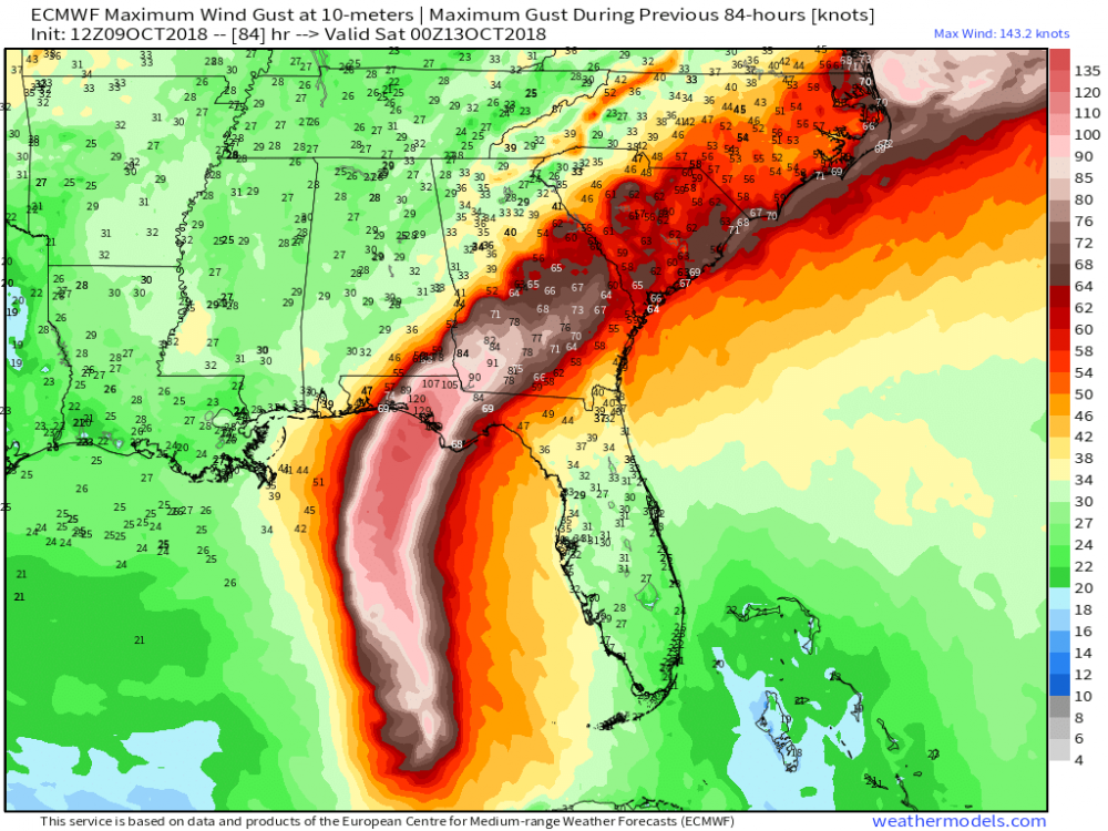
This really shows the western side ramping up as dry cool air works into the storm this is why the models all have the winds beefing up over SC/NC....it may be overdone some but that is wind speed in knts and show 70-80 mph winds on the west side....
i know it's in knots and in general it shows 55 to 60 knots over western nc, not seeing any 70 knot gusts until it reaches eastern nc. Hard to believe it's not a bit over done though but Regardless, certainly an interesting development. 3km nam also shows 50 plus mph gusts in the upstate.
Also of note, hrrr and 3km nam are showing 40 to 45 knot gusts getting close to atlanta too. Nothing earth shattering but probably a bit higher than expected there.
-
38 minutes ago, Queencitywx said:
Yeah, it seems like most of if not all of south georgia is a pecan farm. this cant be good for that.
yeah and what sticks out in my mind is how rare it is to have winds like this there...god knows how long it's been so there are going to be a lot of old trees coming down, never mind the rest.
35 minutes ago, southernskimmer said:I work for a trucking company and we run produce primarily (corn, squash zucchini, eggplant, cabbage etc.) Just starting to ramp up down there again for us. This is absolutely the worst possible time, and it's going to hurt a lot of us in the industry.
sorry to hear...that sucks.
2 minutes ago, Regan said:926.8mb
insane. now close to andrew territory.
12z hrrr is showing some interesting high gusts of 55 to 60 knots over the upstate/western nc, That would be something else if it verifies. Shows 45 to 50 knots here. (and brings whats left of the eyewall through here.


-
 1
1
-
-
thought this tweet by ryan was noteworthy
-
19 minutes ago, downeastnc said:
NAM 3k showing good west side enhancement as the storm goes extra tropical, it drags that band of heavier wind all the way offshore......its probably overdone a bit but not by much.......should see more aggressive wind forecast for NC as all models have anywhere from 50-80 mph winds widespread over the eastern half of the state....

3km nam is even a bit worrisome here with the nw eyewall located right over me for a few runs now. Considering how strong it is, It seems a given now, short of a sudden right turn, that i should get some good gusts here. I'm happy to see FFC decided to extend the tropical storm warnings to athens/here. As bad as it will be at the coast, i think the damage across south/central georgia to trees is going to be scary extensive. A lot of folks are going to be without power for quite a long time.
-
20 minutes ago, Orangeburgwx said:
An EWC would make things a hell of a lot worse... Would widen the windfield and with over 24 hours of open water left it could really ramp up
I was talking about an ewc right before landfall....Unless there is some sudden intrusion of dry air or something, that seems to be the only thing possible that could limit it from maxing out as it comes in.
16 minutes ago, jrips27 said:I think FFC could stand to beef up the max wind gusts more. I have little doubt we're going to see widespread 60-70mph+ gusts in that southwest part of their CWA. They are going to need to update this current one.
yep they are being very conservative....i'm trying not to be too critical since there is still time to adjust but the winds are likely under estimated for sure. The euro has tropical storm force gusts all the way to athens now. I've seen the euro over estimates wind gusts at imes but based on this mornings run and other modeling which are a bit further north, i think a watch is probably a good idea from lagrange to athens at least. I am a bit concerned that areas in central georgia could be caught off guard with how strong the winds are.
-
2 hours ago, jrips27 said:
GFS a little quicker and a tick further north compared to 6z.
Sure looks like it’s going to give a run at upper 3/low 4
wrf now gets it down into the upper 930s at landfall. Unless there is an EWC, sure looks like a bad one for the panhandle and well inland.
uk ticked ever so slightly south but it's in the noise range. wrf/hmon continue to be very consistent with their track..likely bringing 60 to 75mph gusts through much of central ga. If such a track verifies...and Given the robust convection all models are showing on it's north/northwestern side, would expect to possibly see some fairly impressive gusts here too.. So looks like uk/euro vs everything else after landfall. (edit to add...euro came in just a touch further north.) The differences aren't huge but enough to make a pretty big difference wind wise for my back yard.
FFC finally extended the TS watch north and looks pretty good now. Although an argument could be made to extend it north another row or two of counties Considering the robust convection the models are showing on the northern half of the system..
50 minutes ago, FallsLake said:Man it's just going to be nice to see those gust of winds turn from warm/tropical to cool. I'm more excited about the drop in temps then the storm itself.
I'm excited to finally get so much needed rain but amen to that.
-
As jim ross once said calling a match...finally...finally...by god finally.... got some good rain from two cells yesterday totaling a little over an inch. First good rain in 2 months or so...and the worst of the never ending heat is finally over. Hoping to pick up some more before the main event with michael...which hopefully can give me at least several inches.
-
 1
1
-
-
10 minutes ago, lj0109 said:
I wouldn't be surprised if ILM went with a few inland Tropical Storm Watches/Warnings especially around the SC/NC border. CAE just issued a Tropical Storm Watch for the eastern tier of its CWA as of 11AM.
hopefully ffc catches up by this afternoon. fwiw, the icon, 3km nam, and rgem have come north a bit on the 12z run.
eye becoming rather apparent now on satellite. I'd be a little surprised if it doesn't make cat 4 at this rate.
-
15 hours ago, pdw said:
I currently live around Macon, GA, should we be worried about anything besides a little wind and some heavy rain?
i would expect the possibility of power outages in or near macon for sure, depending on the exact track. It seems a given now to see high end tropical storm force gusts with a shot of hurricane force gusts if not in macon, very near by to the south. wrf/hmon have consistently shown macon going through what's left of the northeast/north eyewall.
edit to add, i'm a bit puzzled why they don't have the tropical storm force watches further north. It's interesting that where they have the watches they are for winds of "20/25 knots with gusts to 40/45 knots). So if they are basing it on gusts over tropical storm force and not sustained winds, then watches should be issued for areas further north...at least to macon to augusta. even the furthest south euro is showing gusts into the 40s to near 50mph for macon.

-
1 hour ago, LithiaWx said:
NWS says for ATL to expect TS conditions. We will see I’m skeptical. I may even take a quick ride down to S. GA and see this sucker move in inland.
Personally, i'm pulling for the 11am track..as that keeps the strongest winds away from here while still giving us some decent rains. I'm really nervous about getting a gfs like track and getting such strong southerly winds.
We'll see how big this system is when it makes landfall but right now it's already fairly large. So i would think Even with that track though some gusts to tropical storm force is probable. Sucks the peak will be at night though.
-
1
-
-
1 hour ago, downeastnc said:
With that forward speed places in central and south GA could see winds gusting over 80-90 well inland, then depending on how it transitions to ET the wind field could hold up with rogue gust to hurricane force the entire time its over land especially on the N and E sides.....or it could be only capable of gust 40-45 by the time it gets to the Carolinas...
yeah damaging winds are becoming an increasing concern here. I want the rain badly but i'm hoping the more southern tracks verify. Don't want to deal with power outages or tree damage. Worst case is A track like the wrf/hmon which would mean southerly winds here which would make for some nerve racking times with one of the last oaks I have falling toward the house. (and naturally the highest winds will be at night). The good news is the highest of the winds will be short lived and conditions overall are dry but still a lot of trees could come down given the high gust potential.
-
15 hours ago, Powerball said:
ATL achieved a high of 92*F today, while the record high was 95*F.
It hit 96 here yesterday. There just aren't any words to describe how absurd and disgusting that is.
-
1
-
-
2 hours ago, shaggy said:
gfs would not be welcomed. No wind just rain so a boring system over an area that needs no more rain for the next few weeks to finish drying out. The mosquitoes are hell here right now already.
desperately need the rain here, have had virtually none for two months now.
-
12 hours ago, 64Storm said:
Can we please make it stop?
RECORD EVENT REPORT
NATIONAL WEATHER SERVICE PEACHTREE CITY GA
0435 PM EDT THU OCT 04 2018...RECORD HIGH TEMPERATURE SET AT ATLANTA...
A RECORD HIGH TEMPERATURE OF 91 DEGREES WAS SET AT ATLANTA TODAY.
THIS TIES THE OLD RECORD OF 91 SET IN 1954.I literally screamed that a little awhile ago.
5 hours ago, LithiaWx said:Forecast for 92 today. Record high is 95 set in 1954. What a brutal early October that year was! I’ve lived here most of my life and I’m 37. I can’t remember a hot stretch that lingered into what appears to be mid October. Enough is enough where the fook are the crisp dew points.
My frustration level is about as high as it gets. This is some absolutely sickening garbage. There are things i need to get done but i can't find the will power to do it in this absurd heat. Can't believe we are having to put up with this type of heat in freaking october. It's already 91 here...so not just dealing with 90 degree heat, but MID 90s.....ffc is forecasting mid 94 for athens today.
-
1
-
1
-
-
9 minutes ago, DopplerWx said:
euro and gfs thru the end of the run are STILL ridiculously warm.
this sucks.
it sure does, This never ending heat has been so depressing. Extremes normally average out in the long run and One would hope that maybe all this extreme heat means we will have lots of cold later but watch this winter end up being summer light.
-
1
-
1
-
1
-
 1
1
-


Hurricane Michael
in Southeastern States
Posted
18z 3km nam showing 50 plus knot gusts moving right up along 85.