

Lookout
-
Posts
5,769 -
Joined
Content Type
Profiles
Blogs
Forums
American Weather
Media Demo
Store
Gallery
Posts posted by Lookout
-
-
10 minutes ago, burgertime said:
You're owed a good foot at least. Let's hope it keeps it up for you. Rooting for that solution.
Would be the largest winter storm snow wise here I've ever seen. I sure wish these were 24 hour plots lol
-
 5
5
-
-
") 1 minute ago, Wow said:
1 minute ago, Wow said:That's a great track for W NC/SC, NW GA
A modest event here of around a foot of snow and a nice bit of freezing rain in between
-
2
-
 2
2
-
-
Just now, buckeyefan1 said:
Beautiful


Good lord. It's a whopper.
-
3
-
-
1 minute ago, Blue_Ridge_Escarpment said:
Yeah it’s south but definitely north of its 0Z run. Probably playing into its suppression bias.
Taking a compromise so far results in a big and widespread winter storm for a lot of folks.
-
6
-
-
UK is south but a lot of snow in ga and sc. Although the differences are certainly there, considering this is still 4 to 5 days out, I feel like there is remarkable agreement. Sure wouldn't get hung up on any one run or model though.
-
1
-
 2
2
-
-
Gfs showing 15 to 25 knot surface winds in north ga and upstate at height of storm with 40 knots just off the surface.
-
2
-
-
4 minutes ago, Cheeznado said:
Lousy run for Atlanta but I have a place to stay in the GA mountains so a road trip may be in order. Let's see what the Euro does.
Yep, I think ill be heading north if this verified.
-
At first glance, 12z rgem is west and stronger at 84 vs the icon.
-
2
-
-
9 hours ago, Buddy1987 said:
Good lord! 983 bomb over Wilmington. I did NOT expect this tonight. Soundings look impressive for a whole bunch of us
Lol I was a bit consumed with my bulldogs last night
")

As for this weekend, I'm trying to keep my expectations in check. Being in the bullseye this far out makes me nervous. Given the trends thats hard but realistically the run to run consistency of the models haven't been great..which of course isn't surprising this far out.
The ga and Carolina crew sure deserve this though after watching virtually everywhere else have their day the last few years.
-
9
-
-
3 hours ago, oconeexman said:
I feel ya on that. Tough one to watch for SC.
Yeah i can take not getting snow so long as everyone else isn't getting it either lol. But when its close..ugh. Even worse there was a strong banding over me for a few hours....except it wasn't snow...
 absolutely sickening seeing it be all rain.
The winds between 3 and 7am were ridiculous. I had sustained winds near 40mph between 530 and 6 with a top gust of 54 but i think it might have been even higher across the road.. (large field). As I feared the power has been out since 330.i n fact this is the most power outages locally I've seen in quite a long time. This one has truly sucked.
-
2
-
-
1 hour ago, buckeyefan1 said:

Nothing like the leeside screw zone...although the nam here gives me about 10 flakes...which very likely won't happen. Although I am curious to see how temps behave as this is a bit of a unique situation due to the track of the low. Normally winds are calm or very light in post low nw flow thanks to the mountains and there simply isn't any caa to speak of while precip is ongoing but the models are showing tremendous wind immediately behind the low. Curious if there will be a better temp crash than advertised or will downlope win out (most likely). Speaking of those winds, the ground here is now totally saturated and these high wind gusts are worrisome. As if its not bad enough being left out, losing power and down trees Would really add on an extra layer of misery to this one.
-
1
-
-
81 today....
-
 1
1
-
-
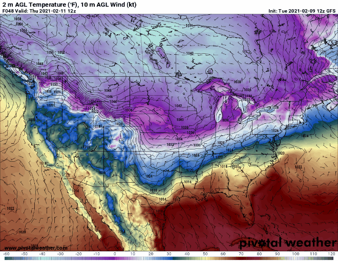
Seeing snow in the mountains sure makes me crave winter. But speaking of snow, here is probably one of the most absurd snow forecasts I've ever seen for a 36 nws forecast. Gfs shows a 14 plus inch liquid the next 36 to 48 hours. . This is near mt. Muir...only up to 253 inches by the end of the afternoon tomorrow.
Detailed Forecast
TodaySnow. The snow could be heavy at times. Areas of blowing snow. High near 24. Southeast wind 65 to 70 mph increasing to 75 to 80 mph in the afternoon. Winds could gust as high as 85 mph. Chance of precipitation is 100%. Total daytime snow accumulation of 52 to 58 inches possible.TonightSnow. The snow could be heavy at times. Low around 23. East wind 50 to 60 mph, with gusts as high as 65 mph. Chance of precipitation is 100%. New snow accumulation of 110 to 116 inches possible.SundaySnow. The snow could be heavy at times. High near 25. East wind 40 to 50 mph, with gusts as high as 60 mph. Chance of precipitation is 100%. New snow accumulation of 73 to 79 inches possible-
6
-
1
-
 2
2
-
-
2 hours ago, Cheeznado said:
Only .03" here since Tuesday noon- all models had a big time fail in the Atlanta area, one of the biggest busts in a long time. Flash flood watch -yeah right.
Happy to say i Have gotten a little over 4 inches here the past few days with more on the way shortly. Needed it too, my area had been screwed pretty bad in the last several weeks. Still, areas north and east of here have gotten as much as 10 to 12 inches per radar estimations. Elberton has recorded just shy of 10 inches.
-
21 hours ago, jburns said:
My two day total is 0.05”. Break out the sandbags.
Thats about how much I got the other day which was the first I've had in a long time. Days back I got zero when a lot of the northern half got soaked. Some rain to the south of me today..so I'm hoping. Sure need it.
-
22 minutes ago, Buckfever2 said:
We have grapple falling in Dallas Georgia at 43°
Same here in Gainesville. Despite temps in the mid 40s I've Been watching for it for the last few days since models were showing such such dry air was in place. Nothing impressive but im sure its the Last shot of any frozen precip around these parts until next season.
-
11 hours ago, wncsnow said:
No matter what happens with this storm, we have been screwed this winter in GA, SC, NC and most of VA
It sure has. I'm frustrated but there would be no telling how pissed I'd be if I hadn't got a snow fix a few weeks ago.
3 hours ago, AirNelson39 said:32.4 and heavy rain is the ultimate middle finger. “But the models underestimate the cad” “it’ll be colder than forecasted” “just cut the zr maps in half and it’s still major”. Well it’s not the 90’s or early 2000’s anymore. We don’t win border line events in the foothills or NW Piedmont anymore. The ZR maps need a complete overhaul on all the models. The long term weather cycle for this area and winter weather is becoming an absolute joke.
There were plenty of warning signs though. As burrel said, temps and dewpoints were unimpressive before hand. Its never good when you see a SURGE in dewpoints before hand like what was seen yesterday. Dps rose into the 20s in a lot of areas in nc. Plus the temps aloft were much higher than normal for a good icing cad event. 800 to 850mb temps above 10c in north Carolina is ridiculous. Not only that the above freezing layer was super deep..on gsos sounding this morning it was from around 650mb to 900mb...which means warm rain. When temps are only marginal that isn't a good recipe for accretion.
Its a shame...it seems like it takes miracles these days to have a cold and dry airmass in place anymore. Its even more insane when you consider how cold it's been just west of here.
-
4
-
-
13 minutes ago, yotaman said:
Pretty sad when the most epic arctic outbreak in over 30 years across the US completely misses us. It is colder in Brownsville Texas than it is in all of NC, SC, and VA.
Its really unreal. Gfs is showing 5 to 10 below tomorrow morning in ms...while most here in ga will only have a couple of mornings get into the 20s. Sad, pathetic, and frustrating to say the least.
-
1
-
-
1 hour ago, HKY_WX said:
Something to remember, this CAD has a direct connection to the parent HP over Canada. Once we start getting the northeasterly wind feed setup later this week, I have a hard time seeing the wedge breaking until the HP moves out of position offshore, which wont' happen until next week. It's honestly going to only get stronger as time goes on and the HP buildings into the Dakotas and eventually slides east.
So we could be looking at several days of freezing rain/sleet coinciding with the STJ impulses that are coming through. The models will likely trend towards this solution over time.
Yep. If this comes to pass, this high and cold is a different beast than the endless parade of marginal cad events we have had recently. The 12z gfs and Canadian are showing minimal temps of the wedge in the mid teens around 950 to 925mb all the way into ne ga. Been a long time since we have seen a cad event that cold.
-
3
-
-
45 minutes ago, burrel2 said:
The surface is problematic... but guys, we aren’t talking about an isothermal sounding from 800mb on down. In fact... we’ve got a down right frigid sounding thanks to a nice insitu wedge. That boundary layer isn’t deep enough and the snow that’s falling will be traveling through cold enough air that we will quickly hit 32 once rates pick up, imo.

Yep..if precip comes in just a couple of hours earlier too it will make a difference too...which has been the trend.. Although there is a fairly deep dry layer, some precip could reach the surface as early as 9 to 10 am up to 85.
-
51 minutes ago, NEGa said:
I love these storms that just sort of pop up. When they do they trend better which is so much more fun than having to watch the 7 day storm fizzle lol
it is certainly looking pretty good for a lot of us to see some snow this weekend. Obviously it would be better not to have a change over but a majority of the decent storms in this area usually do, esp with this type of set up. Even slashing the numbers by a half to a third still gives ne ga a couple of inches. I just hope this one can hang in there
Yeah it never seems to fail ours pop up on short notice. I agree it looks good for most, although down my way I'm on the razors edge as usual. It will come down to the elevated warm layer here. Gfs and euro aren't as aggressive with it as the nam and new 12z hrrr isn't either. I do expect to see flakes fall at least for a while..even if its just a mix. Gainesville to gsp probably will be the sweet spot (outside mountains)
I consider it all a bonus after the 4 to 5 inches I saw in gatlinburg earlier this week but unlike that snow, which was dry, this will be the big flake variety which would be nice. Believe it or not I even saw about a minute worth of sleet last evening around 630 while I was feeding the dog and it was 48 degrees. That is the second highest temp I've ever seen sleet before iirc.
-
Getting hit pretty good. About 3 inches or so.
-
4
-
-
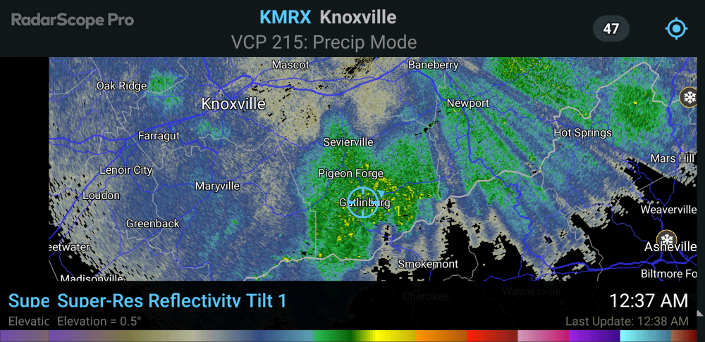
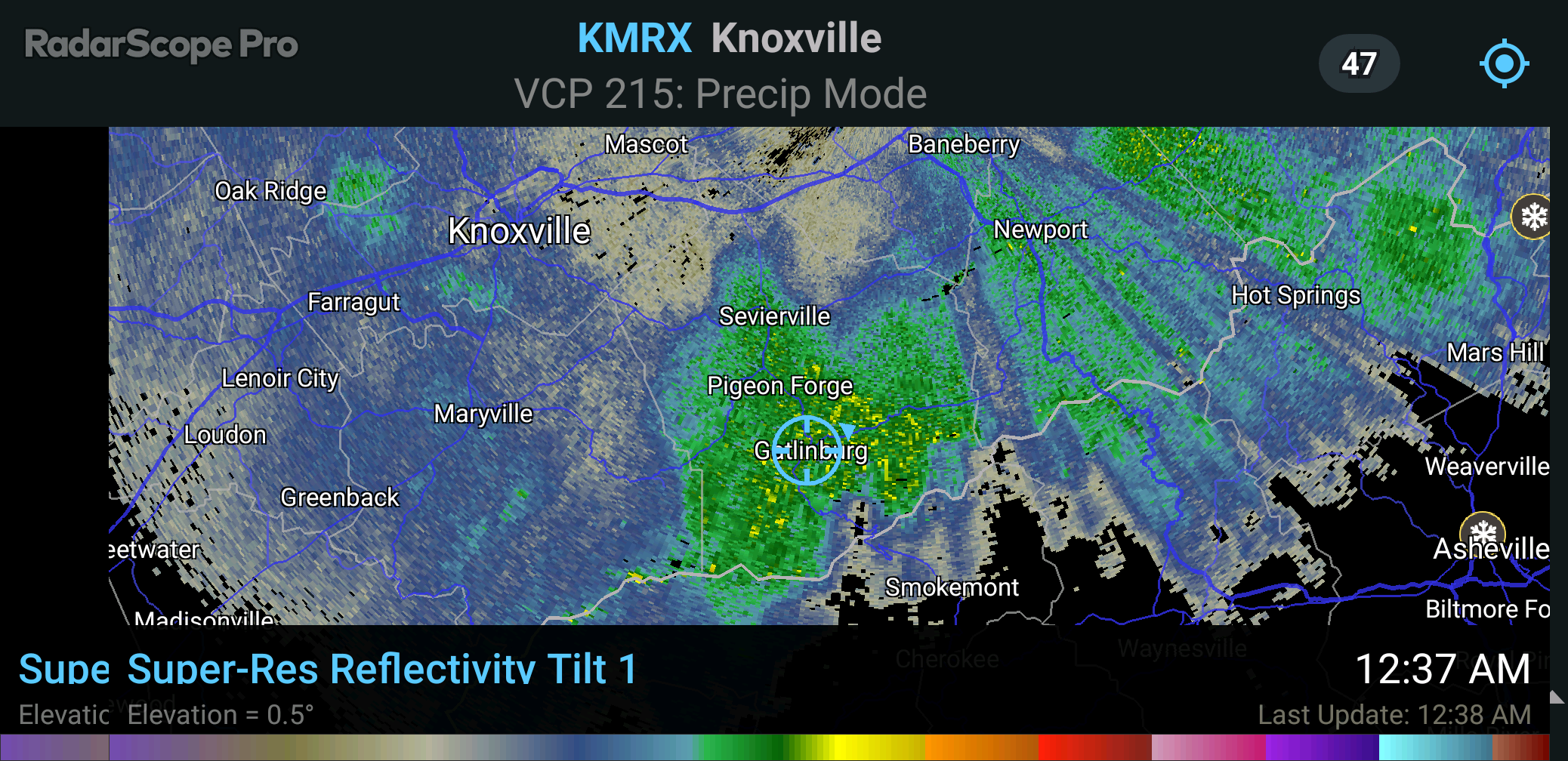
13 minutes ago, snowbird1230 said:
Precip will begin to blossom in next hour..the connection from the Great Lakes is just now coming into Tennessee
Snow is definitely picking up here over the past half hour..after being light for the most part. I have about an .75 to 1 inch on exposed surfaces but now even the asphalt is turning white.. For the first time some 30 to 35 dbz on radar at times . Nice to have some snow with temps subfreezing for a change.
-
3
-
-
45 minutes ago, Buckethead said:
Snow is finally picking up in intensity here in Wolf.
Sent from my SM-G970U using Tapatalk
Same here as of about 30 minutes or so ago..was quite a long lull but ground turning white now.
-
2
-

Jan 15-16 Winter Storm
in Southeastern States
Posted
And again this far out too...pretty nuts.