
ers-wxman1
-
Posts
2,525 -
Joined
-
Last visited
Content Type
Profiles
Blogs
Forums
American Weather
Media Demo
Store
Gallery
Everything posted by ers-wxman1
-
Feb Long Range Discussion (Day 3 and beyond) - MERGED
ers-wxman1 replied to WinterWxLuvr's topic in Mid Atlantic
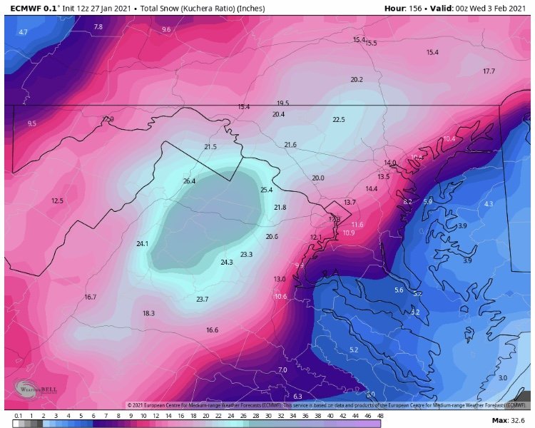
During La Niña, models tend to over amplify weather systems several days out from onset. Overamped, too much moisture, only to see it correct toward the onset time. This latest event is a prime example as across the board guidance was giving a 6-10” area wide event and more like 10”+ on the euro, only to cave to a minor system...even by I-70 standards. Last storm very similar with the euro giving 25-30” at day 4/5 only to be cut back. For the hobbyist, it might be a sting to the gut, but for those working in the field, the inconsistency and wild swings have made forecast ops and communication to high level partners even up into high tier Gov partners a nightmare! Briefings for these “major” events that crop up at day 3-5 in NWP gain attention quickly then to have the rug pulled after you’ve messaged people is tough. One factor, could be minor, but it is a factor in such inconsistent data is the lack of domestic air travel in the U.S. we know the euro model in particular relies on aircraft data which air travel is 1/10th of what it was. Same with other guidance. Perhaps other factors we don’t know about. Niña years are tough as it is. Two conclusions I can draw from this season is... 1) the euro is not what the euro was, and 2) the NAM is useful outside its perceived “wheelhouse”. NAM is great at depicting changes, details in the pattern evolution that is not seen in the globals. It’s done well this season in that regard, overdone with front end waa snow. 3) it’s guidance only! Not verbatim. Know your patterns and climo vs model chasing. I expect the same trends with all the weather systems depicted through the 2/20 time frame. -
NAM is a good model even beyond 48 hours to show you how features may be evolving. Not to be taken verbatim with small details such as exact QPF, but it tends to do well and helps forecasters with trends.
-
Track of that low pressure system will be determined by where the front/baroclinic zone ultimately ends up...hence the waffling of the guidance suppressed vs coming back north.
-
It’s bad and will take many updates and new tools to fix it.
-
Thank you Ravensrule
-
How nice of you. You’ve got no idea who I’am whatsoever so if you’ve got a pair why not PM me on it and we will solve it there. Sound good?
-
You belong on a soap opera.
-
Ooh what a post
-
Jan 31st - 33rd Storm Obs and Disco like it's 1979
ers-wxman1 replied to Bob Chill's topic in Mid Atlantic
Forcing is going north...where the closed upper level tracks...north of it is where the forcing occurs -
Jan 31st - 33rd Storm Obs and Disco like it's 1979
ers-wxman1 replied to Bob Chill's topic in Mid Atlantic
They are guidance and we bought into it for days. -
Jan 31st - 33rd Storm Obs and Disco like it's 1979
ers-wxman1 replied to Bob Chill's topic in Mid Atlantic
Yes! -
Jan 31st - 33rd Storm Obs and Disco like it's 1979
ers-wxman1 replied to Bob Chill's topic in Mid Atlantic
Believe it because it’s correct. Storm was a bust here 100%. -
What’s the difference where it is.
-
Jan 31st - 33rd Storm Obs and Disco like it's 1979
ers-wxman1 replied to Bob Chill's topic in Mid Atlantic
They are easy to pin down... they suck for this area 95% of the time but we choose to accept guidance that produces a pipe dream just like the one poker hand that works out of 100 that keeps us coming back for more. -
Jan 31st - 33rd Storm Obs and Disco like it's 1979
ers-wxman1 replied to Bob Chill's topic in Mid Atlantic
Good luck, it’s all going north -
Jan 31st - 33rd Storm Obs and Disco like it's 1979
ers-wxman1 replied to Bob Chill's topic in Mid Atlantic
I couldn’t get the 6-10 inches generated by NWP for days if you hooked a fire hose up to Ocean City, sucked into the trowal and folded over the trop eight times and aimed it at my house. Remember the RGEM, euro, cmc, ukmet for the trash they put out next time. I won’t invest in another storm in this area until I see the whites of its eyes! -
You will get 1-2 feet! Wish I was there
-
Jan 31st - 33rd Storm Obs and Disco like it's 1979
ers-wxman1 replied to Bob Chill's topic in Mid Atlantic
Everyone enjoying the used to be king euro? Next time you call it “king” remember this solution! It’s no better than any other model. Been bad since summer! -
Family and friends on Long Island where I grew up texting with 1-2 foot forecasts, gusts to 50. This one stings. It was sampled as our storm 5 days ago. “King euro” terminology should be barred from this forum. It’s a used to be king euro. It has sucked since summer.
-
Just have to take lsd to find it
-
It’s not happening! It’s a bust here!
-
How does everyone like “king euro” from 5 days ago? It was only off by 3 states in its assessment! Its no longer as good as it was and it was awful over the summer. Too much reliance on king euro! Euro, CMC, UKmet, RGEM, all overdone.
-
Jan 31st - 33rd Storm Obs and Disco like it's 1979
ers-wxman1 replied to Bob Chill's topic in Mid Atlantic
Snowfall in Ashburn ... 3” -
Jan 31st - 33rd Storm Obs and Disco like it's 1979
ers-wxman1 replied to Bob Chill's topic in Mid Atlantic
It’s all we got lol -
Jan 31st - 33rd Storm Obs and Disco like it's 1979
ers-wxman1 replied to Bob Chill's topic in Mid Atlantic
It’ll snow up there until that primary fully dissipates.


