
ers-wxman1
-
Posts
2,525 -
Joined
-
Last visited
Content Type
Profiles
Blogs
Forums
American Weather
Media Demo
Store
Gallery
Everything posted by ers-wxman1
-
Jan 31st - 33rd Storm Obs and Disco like it's 1979
ers-wxman1 replied to Bob Chill's topic in Mid Atlantic
High end advisory to warning level snows on the front end of the NAM, but that’s all she wrote with the coastal heading north. CCB deform band will be in southern New England on this run. Lucky we get some light wrap around snow and that will be all. No tuck. -
Jan 31st - 33rd Storm Obs and Disco like it's 1979
ers-wxman1 replied to Bob Chill's topic in Mid Atlantic
Maybe they injected the vaccine into it leading to a healthy scenario. -
Jan 31st - 33rd Storm Obs and Disco like it's 1979
ers-wxman1 replied to Bob Chill's topic in Mid Atlantic
That's why you gotta run with the rgem lol If the RGEM is right I’ll cook filet mignon on the grill for 5 people on this forum. My filets are pretty darn good too. Ask Millvillewx. -
Jan 31st - 33rd Storm Obs and Disco like it's 1979
ers-wxman1 replied to Bob Chill's topic in Mid Atlantic
18z Icon...looks like it took a step back on both the front end and the coastal. Real challenge this system has been. Tough to get any model to stay consistent for more than a couple runs. -
Jan 31st - 33rd Storm Obs and Disco like it's 1979
ers-wxman1 replied to Bob Chill's topic in Mid Atlantic
18z NAM is a total front end beat down. 5-8” most places. Little to no snow on the coastal. -
CMC looks impressive. Most will like it, especially the suburbs. Low tuck, stall, bit of mixing then good banding.
-
FF from 21z on
-
No ice feature on the model, I believe it only shows rain and snow, at least on TT. It has all snow in good bands with the low tucked near the coast all the way into 03z Wednesday. Overdone? Perhaps, but so is RGEM. Perhaps though we are seeing signals that the better stuff might be shifting south again. That’s how I would take it.
-
I’ll take it, but might need LSD to actually find it
-
Just like any other model. It has its biases, however in recent events it’s been more conservative when the GFS would bust high. It’s improving.
-
In my opinion this is the best run of the Icon for our area yet. Oddly the snow maps aren’t all that impressive.
-
Icon looks good. Faster and further south development of the coastal. Tucks into the eastern shore with nice banding into many areas by 00z Tue.
-
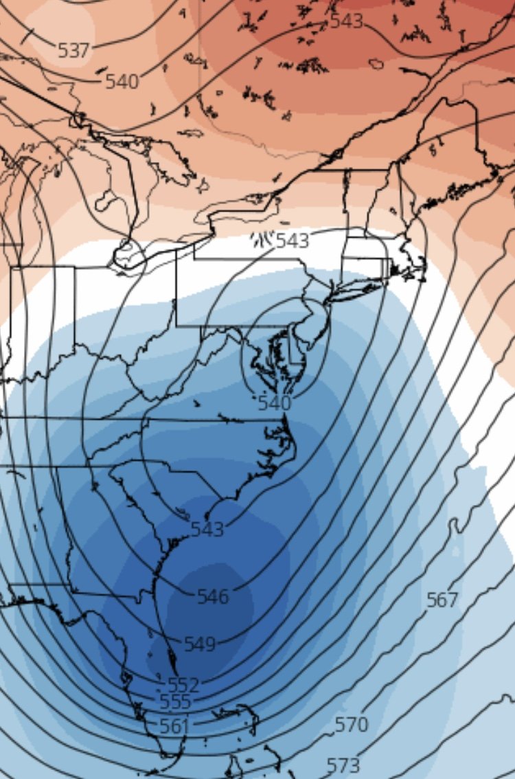
The large discrepancy between all the models is indicative of how uncertain things are. Pattern is fragile with a lot of moving parts, any one of them could be on to something as we do not know what the outcome will be. How ever the model initializes the moving parts is the eventual outcome. Complexity of a Miller B. From climo, they are usually not too favorable for the Mid Atlantic, more so the Northeast and we are seeing those trends. Fact is, the 500 trough and upper low are not all that impressive until later in the game.
-
Attention should be paid to it. The NAM even beyond 48 hours can give insight into how the smaller details may be evolving. Guidance is guidance. We shouldn’t look at it’s QPF verbatim, but more so to understand it’s evolution.
-
NAM 500 trough is swinging across positively tilted and the upper low is closed, but the best forcing is generally north of where the closed circulation crosses. Trough needs to swing across neutral or even a bit negative tilt. Coastal does not get captured or tuck where it needs to and we torch, stay out of the CCB.

-
The chill is back. Cool breeze man.
-
Most of the meaningful snow will happen on the front end thump if these trends continue.
-
The concerns we had all along are rearing their ugly heads. Now that the pieces of energy are coming onshore, models are clueing in on them. Biggest change from yesterday is the 500 pattern. Trough tilt has gone more positive and that will push the best forcing out of our area. Transfer delayed, not much phasing. Precip in two phases and no CCB. That will not get it done in a Miller B.
-
Has the euro been consistent? Mind you here is the euro from just a couple days ago.
-
Mix/rain is like a commercial break during your favorite movie.
-
Anyone have the GEFS mean?
-
Aleet...Aleet...Aleet... Icon is a real snow job.
-
Good run for the first half of the storm. Second half subtle differences, bit more dry air, milder temps, but we don’t see beyond 84 on how the low intensifies.
-
NAM is good for analysis of how the pieces may be evolving. There are good things with this. Not to be taken verbatim but more to see how the pieces are coming together.
-
Plausible.