

Maestrobjwa
-
Posts
10,335 -
Joined
-
Last visited
Content Type
Profiles
Blogs
Forums
American Weather
Media Demo
Store
Gallery
Posts posted by Maestrobjwa
-
-
Just now, Ji said:
I mean its obvious its not going to snow this year but we cant even get something legit to track outside of 9 days
It's not a bad look on the GFS for next weekend I don't think...aside from the verbatim solution on an OP 9-10 days out, lol
-
4 minutes ago, jaydreb said:
Next week’s tracking is going to be a replay of this past week.
Man I hope not....I mean I think we'd all be about ready to jump off a cliff! It would be crappy even by our standards to get two coastal two weeks in a row during prime climo to not produce. C'mon, we deserve for this next one to work out, lol
-
Just now, Porsche said:
Be concerned about temps.


While it is obviously wayyyyyy too early to even think about temperature specifics on an op run...just the mere image of that kinda ticks ya off knowing this is the reality of THIS weekend, lol But for now...good to see the models picking up a storm for that time period...hopefully we have a better source of cold air that time.
-
25 minutes ago, RevWarReenactor said:
Okay, fair enough. I appreciate all your information. I really have learned a lot! I understand what you are saying that our seasons here really are hit or miss, especially lately. But even for a miss season, this is still pathetically bad. What are you at 8 inches for the year and average about 40? That is bad even for a bad year.
I guess I just need to focus my attention on other stuff and forget about snow here this year, and hope to chase somewhere again in February and hope for better years in the future.
Ehhh I wouldn't say forget about it just yet...there are some years where it can be crappy...but then we do get that one. But perhaps just casually look for now, lol
Another resource to refer back to is the BWI snowfall history:
Just one look at that will give you an idea of how wild the swings in snowfall can be around here (now of course that list doesn't account for n & w of the cities, but you'll still get a pretty good idea). The only decade where it snowed consistently year-to-year is the 60s (man that must've been awesome!) But then early to mid-70s? Futility, lol (but then we get two boom winters of 1977-78 and 1978-79).
-
 1
1
-
-
2 minutes ago, Always in Zugzwang said:
I sure have heard it, several times...and have seen it performed live a time or two. You're absolutely right, the same motif shows up throughout. It also has one of the more unusual transitions from the 3rd to 4th movement (no pause, really, it just goes right into the 4th).
Ohhhhh I LOVE that part...It almost gives you chills (but can you imagine the shock of people back then? Lol And this wasn't the only work on that program that night).
It is so suspenseful (and of course we know where it's about to go). It's a slowly rising phoenix that erupts into a blaze of glory! (and of course such a transitional part was one of Beethoven's many glass-shattering innovations that others would follow)
-
1
-
-
27 minutes ago, mappy said:
Ava is great! I am biased, but she really is down to earth and does not like hype or under playing things. yes, she has made some bad calls (the weekend event not long ago) but i've never ever considered her to be a weenie.
Ya know I have to wonder...If you're a meteorologist, does loving snow serve as a hindrance or a help? I mean, I suppose if you love it and your a bonafide met, ya gotta be extra conscientious about putting it on the shelf in favor of making an unbiased forecast.
-
9 minutes ago, psuhoffman said:
This run the GFS consolidates too much of the energy along the front into the lead wave...and that positions the trough too N/S vs E/W and makes it really hard for the follow up wave to develop...the timing also sucks as the next NS wave that COULD phase and develop a storm is too far behind. The potential is there it just misses the moving parts coming together right. Then we get the waves but they all manage to go just north of us...which is the risk in that pattern.
But overall...would you say this would be at least a slightly better scenario than what we have this week? (i.e. more cold air around)
-
1
-
-
1 minute ago, ers-wxman1 said:
Geez Louise! This forum is even making me look like a positive person. It’s disappointing for sure, but it’s SNOW!! It falls, it sticks, it melts. Just had a good friends father rushed to the ER for 5 hour open heart surgery for aortic dissection. Nearly lost him on the table. There are greater tragedies in life.
My goodness...glad to hear that he survivex! And you're right...there are indeed greater worries in life. Why we get like this on here is baffling...but my thinking of it is: sometimes, we look to snow as the "happiness". The exciting thing to look forward to...And while enjoying snow is what we all do here, the problem comes in wrapping up that "joy" in getting snow--instead of letting ourselves be fulfilled by other, much more dependable things (and outside of winter, I'm sure we find them, lol). But during winter, it's like...."ah, this is gonna make me happy!" and ya start following every model run looking for a promise of "joy" in the immediate future. So, when it doesn't come...folks can be depressing on here since it can feel like something is being stolen or away, or happiness denied. And it doesn't matter how realistic the chances are of a particular event...no snow can still be depressing even if you expect it. But it's a flawed thought pattern, though...
(A bit of a ramble, but I suppose this is just an observation of my own psychology and other's, lol)
-
1
-
-
22 minutes ago, jaydreb said:
So what happened? Yesterday there were positive posts about the upcoming look from around Feb. 6-13. Were the overnight runs that bad?
I didn't think they were that bad for that. (I mean, no degradation of the look of a southern wave and colder air in place than this week) But I'll defer to the more experienced posters in case I'm not looking at it right...lol)
-
1 hour ago, Always in Zugzwang said:
OK, while I definitely appreciate music, I cannot read it all that much. What piece is that from??
(ETA: Of course!! From the 1st movement of Beethoven's 5th Symphony? Considering @stormtracker issued the "warning" comment, and looking at the musical notes now in my mind.)
Correct
 Probably the most famous 4-note motif in the history of music, lol (Have you ever listened to the entire symphony? If you haven't...DO IT!!! Haha You will discover just how many different ways he incorporates that same
"short-short-short-looooong" pattern throughout the whole work!
-
Just now, uncletim said:
Lol Perfect! (are you a musician?)
-
1 minute ago, psuhoffman said:
We have 2 threats I see...a trailing wave after the cutter...or a west to east wave around day 11-13. But we would need it to stay progressive. Amplified systems would cut.
I've been curious about the first of the two...Now I'm not clear on the whole cutter setting up a transient 50/50 thing. Is this the kind of setup where that can happen?
-
3 hours ago, Always in Zugzwang said:
I think you misspelled "FOX" there...(ducking for cover).
Dang it man what did you just do

-
1 hour ago, psuhoffman said:
I’ll admit I agree with @Ji on one thing. Missing a heavy wet snow is depressing. That is my favorite. When we snow at 32* and it’s paste that sticks to everything and perfect for making a snowman or fort with the kids. Of course the problem is for me to get a wet snow is invariably has to be raining in DC.
Not that I’ll kick the idea of 8” of cold smoke on the gfs out of bed but those kinds of storms always have less suspense and excitement.
What do ya mean...ya get a thrill off of the borderline storms? You sadist...lol
But I'm kinda split on the wet vs cold thing...but wet is pretty exciting! The only downside is...it's more back-breaking to shovel it! But hey--I'll take it anyway we can get it, lol
-
1 hour ago, psuhoffman said:
Yep--that would be almost right for our every 3-4 year footer!
But seriously, I do hope we still see this potential by the end of the week...if we do, it might turn into the best chance we've had in four years, lol
-
18 minutes ago, Always in Zugzwang said:
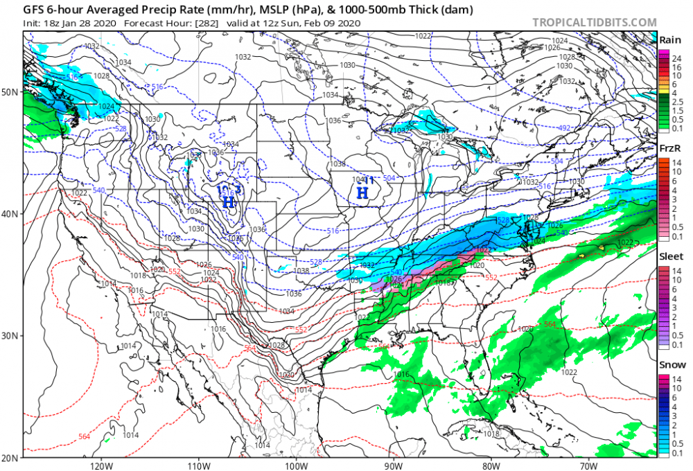
Well, if you're looking at the *total* QPF through that time (I'm looking at TT site), then yeah, it would appear like huge swaths of moisture because it's a total amount over all those hours. Sort of like a Jackson Pollock painting (I use the term "painting" very loosely, hahaha!). Much larger area then, of course, would be covered by something, especially when you get out in time. But if you're looking at the 24-h amounts, you should see more "motion" (for lack of a better word) as a system moves through...it will increase, then decrease, over an area for various 24-h increments.
Now, I was actually talking about like the actual map that shows the rain/snow. Like when it looks like this:
-
12 minutes ago, psuhoffman said:
Let it go. Incoming on 18z gfs. 1041 high on top of a stj wave train.
Question...now when you look at ops past like 200 hrs...why is it all the precipitation look like huge swaths of moisture? (like somebody took a butter knife and slathered streaks of graphics on the map,l Is that basically the computer saying "eh, it might be precip between here and here" or is it because resolution is weaker at that range?
-
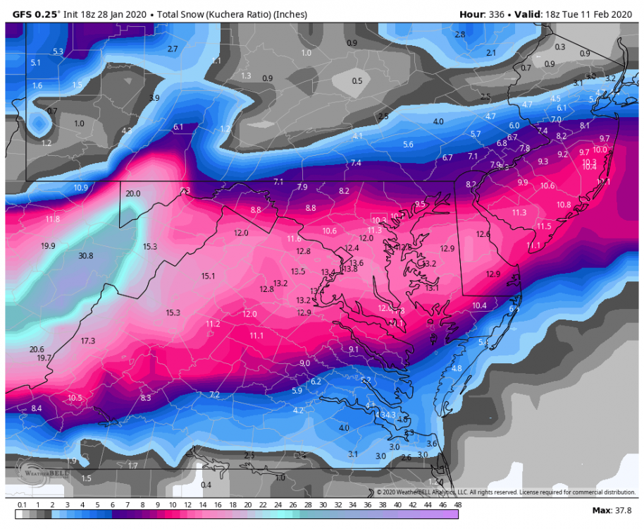
I'll hold on to this trend to the bitter end...lol We're just in February, so that one footer could still happen!

-
18 minutes ago, stormtracker said:
We can't even get a 10 day digital snow right. The 6z beauty just slid south. Still early to give up on winter though.
But why does where it ended up matter at this point? The idea if an stj wave (if I'm labeling it correctly) and a NS wave being in the same vicinity is still there (and the idea of the cold air mass being better this time). For Day 10, I think that's just fine
13 minutes ago, Always in Zugzwang said:Yeah, looks like the trough doesn't quite dig as much as the 06Z did (or the other couple of previous cycles that had a good event). So it doesn't get going really until it's well offshore and it doesn't "turn the corner" much up the coast for us. But...the idea is still there at that range, and has been for a little while now. Guess that's all we can ask at this point.
Precisely. Really, I think I've mentally moved on from this weekend...and instead am looking at it as the start of the next tracking IF this look is still there by Friday.
-
2 minutes ago, stormtracker said:
At some point, we have to realize that no matter what the track is, we are missing a key ingredient. It's going to be tough to get a snowstorm without cold air.
Unfortunately...man, this is gonna be a tough one to miss. Any other time...we'd be set with this track. But this is the one late January day where we, for whatever reason, have difficulty bringing in cold air, smh If we can't pull off a bit of a miracle here...man I hope the better look the following week continues to move forward in time and we can cash in on that...because this is getting kinda ridiculous even for us!
-
42 minutes ago, psuhoffman said:
problem is there will likely be a few days of dead space behind it also... there could maybe be a little NS vort diving in behind if it ends up not phasing that could bring a clipper type snow. That kind of thing wouldnt show up at range...but Ive seen hints that is possible. But other then a fluke type thing like that...after the weekend we have to wait for the dump of cold getting ejected out of AK. As that presses down into the midwest there will be the natural see saw effect on the longwave pattern and we will ridge here so that first wave will most likely go to our north...maybe so far to our north we don't even get any precip from it. It's after...later that next week that things could get interesting starting with the chance at a trailing wave along the front and then see if the STJ wants to play nice after that.
Which means this weekend may only be good for the beginning of chase for NEXT weekend? I think I'll take that...lol
-
39 minutes ago, Sparky said:
Don't know if you were around for it but '77 didn't suck for winter ambiance. Snow cover for most of January into early Feb because of the frigid temps which froze Chessie Bay to unprecedented level. There was also a decent Jan. storm around the 11th that dropped 5-6 inches in Baltimore.
Ah yes...I can see that on the record here that we got 8.5 in Jan...at least we got the ambiance! (and no, I wasn't around back then, lol)
-
1 minute ago, RevWarReenactor said:
It was? 70's looks hit or miss to me. Off on and on with the above average winters actually.
A lot of years in there with 16+ inches which would be a miracle from the heavens at this point. We can't even do an inch of snow anymore.
I'm not sure what area you live in, but 1970-1977 primarily sucked and were below average snowfall every year at BWI!
-
3 minutes ago, WinterWxLuvr said:
There are a few gfs members that say don’t give up on the weekend just yet
Man we played this game with last weekend's rainer...lol (I'm more intrigued by the potential just beyond that...hope we'll have something to chase by Friday!)


Mid January/Mid February Medium/Long Range Discussion
in Mid Atlantic
Posted
So like...is everybody just completely baffled about this NAO no longer being negative in the winter? Has anybody offered any actual explanation?
And agreed...we may have to get something in a tiny passing window. (To me, next weekend would be the chance for that...at least we got a LITTLE more cold air to work with...)