

Maestrobjwa
-
Posts
11,990 -
Joined
-
Last visited
Content Type
Profiles
Blogs
Forums
American Weather
Media Demo
Store
Gallery
Posts posted by Maestrobjwa
-
-
13 minutes ago, Ji said:
On the ground?
Read my mind, lol And the snowy ensembles for that storm were right...only reason it wasn't a blockbuster was from a specific wave interaction they couldn't possibly see that far out.
I for one have enjoyed the glacier (despite the inconveniences). And I'll always remember this winter for that!
-
 1
1
-
-
40 minutes ago, psuhoffman said:
we will continue to see short term cycles of less and more snow but over top of that is the long term decline. Each up will be less up and each down will be more down and eventually Baltimore will have a winter climate similar to what Raleigh used to have where snowfall is an extreme anomaly and not something you expect in any given winter.
Well let's hope Raleigh climo is still a few decades away...I'm not ready for 55⁰ to be normal in the winter, lol Although...shoot: If that happens the suppression shouldn't be a problem anymore! We oughta be able to get a blizzard the way NC did in that scenario, right? Or the dang December 2018 storm oughta be able to get up here instead of there!
-
3 minutes ago, Paleocene said:
Trust me, we used to fail. I had a few disappointing winters in the 90s as a kid (and some great ones), and I lived further north. Now we are more likely to fail!

As a fellow 90s kid I remember some of those fails, lol But I do remember more moderate snows of 6-8" as opposed to what we get now...
-
 2
2
-
-
1 minute ago, SnowenOutThere said:
I think PSU would agree with my take on this but its never quite that easy. Its background presence has been increasing. Some setups might still be cold enough, some setups wont be. Over time our marginal setups will only become more likely to fall on the not cold enough side. So its not like some year will mark the end of our marginal setups forever, instead its a slow decline. Ofc to not make this political this phenomenon is unique to only snowstorms and has no broader causes, effects or solutions.
This here...that's what I had assumed the changed would be. But I don't remember this stuff happening before 2016 or us having discussions about perfect track rainstorms in February. In fact I distinctly remember a snowfall in 2015 where it was 50⁰+ the day before and we were are thermostat watching...and the next day we got several inches! It all just feels sudden to me.
-
4 minutes ago, psuhoffman said:
This storm is taking a perfect track. It’s just too warm for DC
So 2F warmer...did the effects somehow accelerate after 2016? Because I'm sure 2014 or 15 had setups like this that worked, didn't they?
-
11 minutes ago, NorthArlington101 said:
Alright @psuhoffman weenie model or no...THIS is an example of what should be able to happen, right? And even the NAM...low got deeper, solution got colder...
-
2 hours ago, psuhoffman said:
50s is normal in March. That won’t be a cold pattern but there is enough decent in other areas we could get a wave to track under us if it times up with a transient 50/50 feature. You only seem to pay attention to the pacific and ignore other factors. But we’re getting that this weekend and its rain so maybe we can’t snow anymore in hostile pac regimes and the last 10 years is just what is normal now.
Wait is this is a logbook fail incoming? Now see I thought this weekend was rain because the storm got here too late and the cold air had already escaped (and that if it were 12-24 hours sooner it would've been snowier) But you're saying this woulda worked before...
Man I still don't get how the switch just flipped so quickly like that. This kind of setup work between 2010 & 2015? I hope this is a PDO issue and not the other.
-
2 hours ago, psuhoffman said:
AIFS has been really interested in Feb 24. I’m calling it the @Maestrobjwastorm
Listen if that happens I will own ALLLLLLL of it and take my shots with little complaint, hahaha
BUT if we are still tracking this by Wed and then it goes poof I'm just gonna sit here giving y'all side eye
")
-
1 hour ago, snowfan said:
This happens in the threads where we don't verify income and offshore assets.
Cayman Island thread...lol (Wonder how cold they were when Cuba hit freezing last week?)
-
42 minutes ago, TSSN+ said:
Not obvious for all that are reading though.
-
2 hours ago, Paleocene said:
I haven't given up yet. The track keeps me intrigued, and the moving parts (maybe something will go right for once instead of wrong as with recent NC storm). And the simple fact that we have barely gotten any moisture since the snow/sleet beatdown storm. But like with the Euro image i posted above, I'm very worried about temps for my backyard even if the track trends toward "perfect." Silver Spring doesn't do marginal well.
Well...if we can't get snow, rain wouldn't be the worst thing in the world. At least it'll clean off the cars
-
1
-
-
46 minutes ago, CAPE said:
This is all silliness and has no relevance to what actually occurs. Weather does what it does when it does. Doesn't give a fuck about weekend rules or whatever else.
You're right...of course it does whatever the heck it wants. And this isn't scientific in the slightest. It's no different than the baseball player refusing to wash a sock during a 30-game hitting streak...some are a little more like that than others, lol So err...
See ya on the weekend during our next HECS
(or whenever it happens...hopefully, lol)
-
39 minutes ago, CAPE said:
This is all silliness and has no relevance to what actually occurs. Weather does what it does when it does. Doesn't give a fuck about weekend rules or whatever else.
Of course it does whatever it wants. But I'll see ya on the weekend of our next HECS
(whenever it happens...Hopefully, lol)
-
 2
2
-
-
Ah well..if having a glacial snow with almost 3 weeks of arctic air that barely got out of the teens--is the high point of a la niña winter, that is not bad at all. This has actually been a lot of fun! And It seems our misses weren't logbook misses but the thing I protest the most about ninas: the pesky NS, lol But it was plenty of cold, that's for sure!
For next winter...I do hope we can take advantage of this niño and get it in a workable position. If we want a big dog soon, we can't afford to waste the second Niño of this decade...we only average 2-3 per decade to begin with! And yes I'm unabashedly HECS hunting too--niños are always our best shot at those!
-
4 minutes ago, Scarlet Pimpernel said:
Agree. I can recall several advisory to warning-level snows between late February and mid-March, it's really not all that rare of a thing relatively speaking. I know there are those who tend to thumb their nose at later season snow events but we've had a decent number. And in not the greatest setups, too.
I'll just note I'm just talking the last week of Feb not March. March snow is annoying to track but it most certainly happens.
-
2 minutes ago, psuhoffman said:
dude do you realize how rare getting a 5" plus snowstorm is on any particular week? How often in the last 20 years have we had a 5" snowstorm ANY week?
Yeah I know. I'm just saying...this weeks feel like worse luck than other weeks call it a slight superstition or whatever. Like sports when a team just doesn't play well in a particular situation over decades.
It's just like the "weekend rule"...snows more on the weekends than it does during the week!
-
1
-
-
19 minutes ago, psuhoffman said:
What's wrong with saying something in a way that's less insulting?
I think a few people struggle with that on this board. But that's the nature of online debate and disagreement....
-
21 minutes ago, snowfan said:
Suns out, guns out. Get those lawnmowers tuned up. Crocus bloom watch.
Turrible. Just turrible.
-
1
-
-
46 minutes ago, HighStakes said:
You are constantly harping on this. Sure, the overwhelming majority of MECS and HECS have occurred before Feb 20th but to say there been little in the way of any snow during the last 1/3 of February is simply not true. Your own words are "very, very few snowfalls of any kind those two weeks". You couldn't be more wrong and I'm not trying to be nasty. Please provide data or do some research before making such a bold statement. I'm only calling you out on this because you make reference to it quite often. Just take the last 40 years. 1986,1987,1993,2003,2005,2007,2014,2015,2021 all saw events and some of those years were quite snowy periods. There were many years with close misses that still yielded some snow for certain parts of the region or had significant storms the first few day of March such as 1984,1994,1996,1999,2009,2011,2017 and 2019. My set of years are based from Feb 20th through March 1st. If you include the full last 2 week of February like you did in your post then your position worsens greatly. 2013 got a little snowy for NW and of course the epic fail the first week in March. This isn't even including countless C-2/3 inch events not even worth mentioning.
Let me clarify by saying that when I say it doesn't happen often I'm talking primarily of snows that are warning-level (5"+ And I'm only speaking of the cities (i.e. BWI) not so much N&W. Sorry I didn't clarify that part.
Now admittedly...what I don't know how to do is how to isolate Feb 20th-28th and last week of December to see just what fell each year. What's the best way to do that? I'm more than willing to take time to put the stats together I just don't know how. I need to see how many snowfalls over 5" we've gotten the last week of December and the last week of February AT BWI.
And btw I'm not at all talking about March. We got 5" there several years ago.
-
2 hours ago, 87storms said:
Definitely not the last shot by seasonal perspective, but I find March to be truly overrated in the snow dept. Really can’t rely on that around here. But it is kinda weird how we don’t get much snow it seems in late February…it’s kinda like our late December void.
Don't get me started, lol Historically it's always been that way! Very few warning snowfalls during those weeks. No scientific reason for it...it just never works out. Even 2010 had a fail that last week of Feb, and then that which shall not be named happened the last week of Dec! Again, nothing scientific...but it's like sports when a team just never plays well in a certain stadium or park, lol
-
1
-
-
Just now, Ji said:
I love being the lead overnight meteorologist when no is awake or believes lol
Anyway this a a decent shift
Till 6z
How did the AIFS look?
-
3 minutes ago, Ji said:
Ai models probably don’t have the computing to forecast precise phases
This is gonna be an interesting test for them.
-
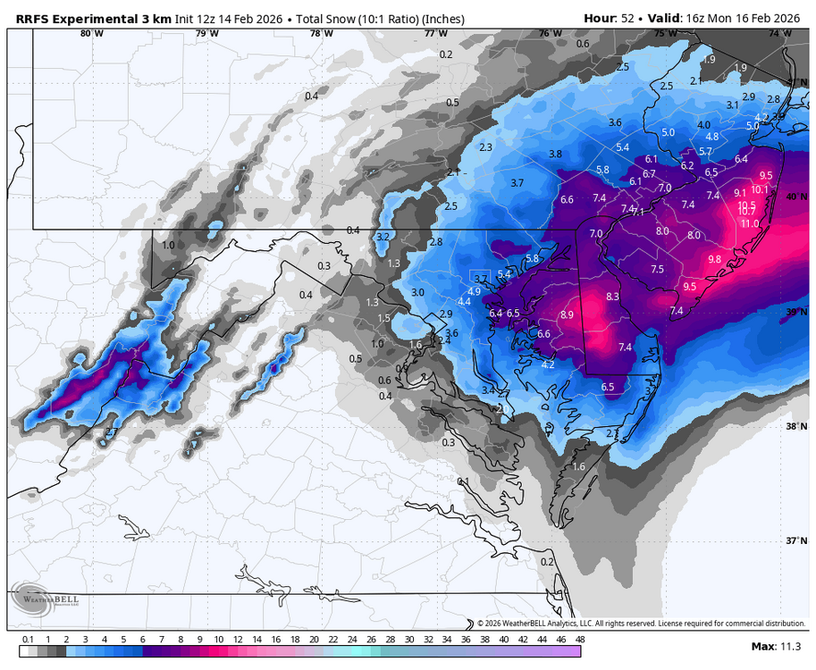
Just now, bncho said:
very close to a region wide MECS. NYC gets the big totals this time.

Oh wow
-
23 minutes ago, CAPE said:
Magnesium supplements usually do the trick. I was taking it for muscle recovery and sleep. But then I found out it had a side effect lol, at least for me. Dose dependent. I backed it off and now ok.
We've gone from extrapolation to excrapolation
-
 3
3
-

February 2026 Medium/ Long Range Discussion: 150K Salary Needed to Post
in Mid Atlantic
Posted
This! @psuhoffman Not sure if your sae my other post, but I was asking about the samw thing: If we're headed for Raleigh climo then suppression would not longer be an issue, right? If the boundary is going further and further north...we should end up getting more southern sliders to hit us, right? Dec 2018 oughta be a hit in that scenario, lol