
Stormlover74
-
Posts
20,286 -
Joined
-
Last visited
Content Type
Profiles
Blogs
Forums
American Weather
Media Demo
Store
Gallery
Posts posted by Stormlover74
-
-
1 minute ago, Bxstormwatcher360 said:
Interesting that the temps stayed at freezing in the city itself,but ratios went up as you went north even with less qpf. Im kinda shocked because there is almost 3 inches of fluff outside and its still snowing. Temps were 28-29 here whole time.
Ratios were very high in that band as well.
-
 1
1
-
-
3 minutes ago, the_other_guy said:
or it’s still 32° in Central Park and never got back to the 20s as forecasted.
It will be interesting to see what the totals will be in central Park today versus the airports
We already know. 2"
-
2
-
-
Nice final band coming through. Maybe an additional half inch
-
5 minutes ago, North and West said:
I agree, and I think that’s my point. They’re a good guide, but imperfect.
.Almost impossible to forecast because it's a nowcast situation so mt holly couldn't really forecast 2 to 4 locally 10
-
1
-
-
-
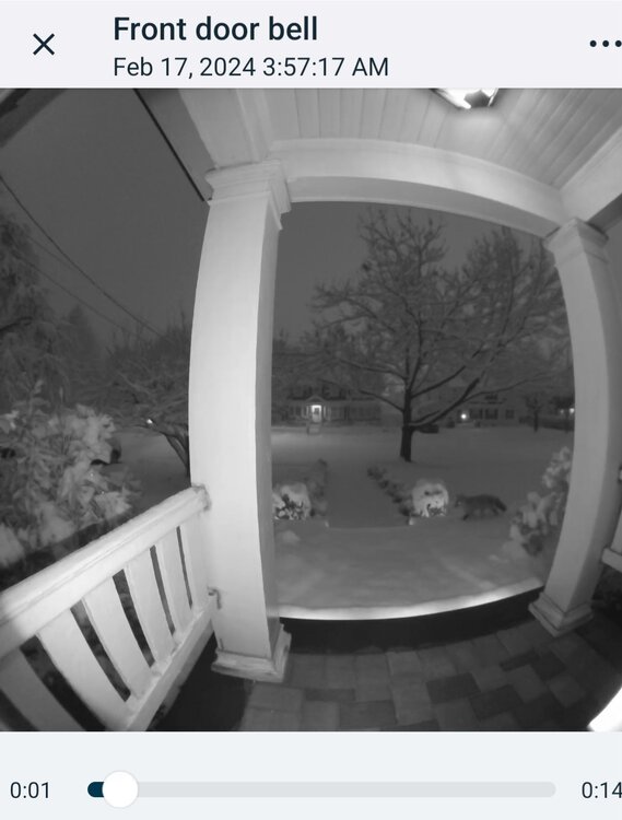
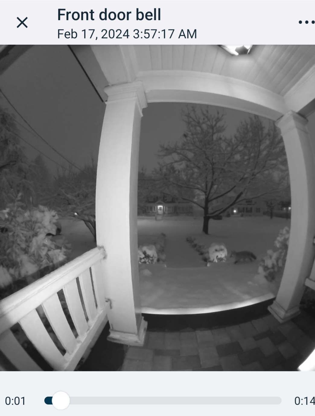
Fox in the snow
-
8
-
-
Should probably be a warning here but I realize it's pretty localized to the southern part of union judging by the radar the past few hours
-
2
-
-
Just woke up. Gorgeous out. Eyeballing 3 to 4 but hard to tell. Didn't quite get under the allsnow band
-
2
-
-
Very light snow and 34
-
3 minutes ago, Krs4Lfe said:
Tomer Burg says the northern band of snow is dying out as the southern band takes control and strengthens, which would lead to a dry slot north of Trenton. Concerning if it happens.
So the area he had getting 5 to 7? Lol
-
1
-
-
2 minutes ago, Tatamy said:
Snowing in the Harrisburg area. Looks like visibility’s come down fairly quickly with the onset of precip.
I just don't see that area and along the M/D line only getting 1 to 3 unless all the heavier echoes go northeast
-
There will be a lot of positive and negative busts with this one. Doesn't look like a uniform 2 to 4/3 to 5 anymore
-
2
-
-
Down to 35 after a high of 43
-
8 minutes ago, MJO812 said:
Very nice
Now let's get more bumps so we can get 3-6 lol
I think the bumping is done. Now we watch where the banding sets up
-
3
-
-
-
Wwa issued
.EXB.KOKX.WW.Y.0005.240217T0500Z-240217T1500Z/
Western Passaic-Eastern Passaic-Hudson-Western Bergen-
Eastern Bergen-Western Essex-Eastern Essex-Southern Westchester-
New York (Manhattan)-Bronx-Kings (Brooklyn)-Northwest Suffolk-
Northeast Suffolk-Southwest Suffolk-Southeast Suffolk-
Northern Queens-Northern Nassau-Southern Queens-Southern Nassau-
302 PM EST Fri Feb 16 2024

...WINTER WEATHER ADVISORY IN EFFECT FROM MIDNIGHT TONIGHT TO
10 AM EST SATURDAY...

* WHAT...Snow expected. Total snow accumulations of 2 to 4 inches.

* WHERE...Portions of northeast New Jersey and southeast New York.

* WHEN...From midnight tonight to 10 AM EST Saturday.
-
1
-
-
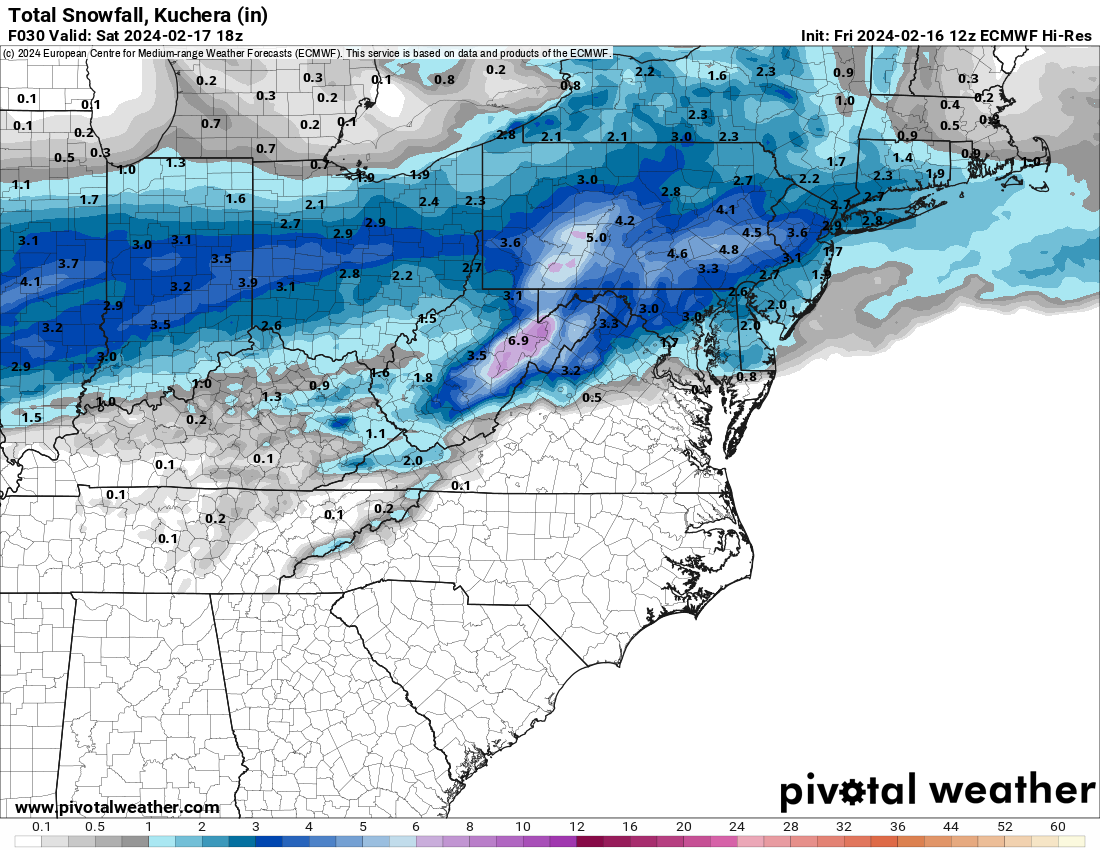
Nam is very nice
.thumb.png.de9947615b91559dbf16a7db9ff5dc53.png)
-
2
-
-
Probably too far north. Screws Philly to DC
-
6 minutes ago, RU848789 said:
Nice...

Yeah it likes our area for the heavier band but kinda screws south jersey. The rap did the same thing but we'll just have to watch the radar
-
1
-
-
Looks like euro held serve
-
1 minute ago, MJO812 said:
What marginal temps ?
For like the first hour but even then if it's 32-33 it'll stick to non paved surfaces
-
1
-
-
8 minutes ago, jm1220 said:
RAP looks really good. High end advisory event for most. That fronto band across central PA and NJ keeps ticking north. Between that and the main low may be a mini shaft zone so if that keeps going north Philly and I-195 might be in subsidence, but the consensus now is the best snow there.
SI jackpot
-
1
-
-
Just now, winterwx21 said:
Glad to see this trended our way on the 12z models. 2 to 4 looks like a good call for most now. WWA for my area and as others have said, it'll likely be expanded north this afternoon.
Yeah at least everyone south of 80 should be in one. And I won't be surprised to see a heavy band north of there
-
1
-
-
7 minutes ago, SBUWX23 said:
temps may be just above freezing initially but Tds in the teens that will drop down once steady snow begins.
Yeah should be in the upper 20s within an hour or two of the snow starting
.jpg.462d2ee3aaa81d0ca9be52ba7745c8ea.jpg)
.png.8345d4bf1663f8f658465cc35cd19888.png)
Refresher snow & obs between ~midnight and Noon Sat Feb 17 2024
in New York City Metro
Posted
Same. By less than 3 miles I got 8 instead of 3