-
Posts
2,587 -
Joined
-
Last visited
Content Type
Profiles
Blogs
Forums
American Weather
Media Demo
Store
Gallery
Posts posted by high risk
-
-
On 3/29/2023 at 10:09 AM, Kmlwx said:
I don't want to start the whole global warming conversation - but I could see our severe season getting extended with a warmer/more humid climate. Late March could become a more fruitful severe producing time of year.
Interesting thought. In my mind, the severe season here doesn't really kick in on average until around May 10 (yes, there are exceptions), so moving that start up to late March would be a big jump. How about if we try a smaller increment and the severe season in mid to late April instead?
I could also see an introduction of a fall season (aside from tropical events). We usually end up just a bit cool for those dynamic autumn systems.
-
 2
2
-
-
-
Always always always use the NAM Nest for temperatures in a cold air damming situation when other guidance is faster trying to erode the wedge.
-
 2
2
-
 3
3
-
-
6 hours ago, MN Transplant said:
This morning’s NAM was the worst of the bunch (midday 40s). The GFS took a step back too. Friday looks gross. Saturday is still unsettled.
Most of Friday looks nasty for sure. That said, we'll end up with a high in the 61-65 range due to the temperature at 12:01 AM.
-
 3
3
-
-
Definitely some sleet pellets mixed in here in southern Howard County. Models are pretty insistent that the heaviest downpours will be after dark - some elevated CAPE suggests that a few rumbles of thunder aren't out of the question.
-
 3
3
-
-
1 hour ago, WxUSAF said:
RGEM is a nice period of snow for Baltimore area but temps mostly above freezing. GFS shows temps at or even slightly below freezing. 3k NAM has a flurry maybe?
The NAM Nest is pretty clearly a dry outlier; it looks like every other model (including the NAM parent) has snow here tomorrow. You're spot on, though, that the temperatures are super tricky. It's tough to imagine a scenario in which the roads get messy (unless the rates are *really* impressive), but I can definitely envision some accumulation on grassy surfaces and decks.
-
 6
6
-
-
12 hours ago, paulythegun said:
Haha I'm definitely just now realizing that my weather model knowledge is extremely dated. In my head, NAM was just upgraded from 4k to 3k. So is the FV... whatever model the replacement for NAM?
Sort of. The FV3 is the model "core". The GFS already uses the FV3 core. The NAM uses the NMMB core, and the RAP/HRRR use the ARW core.
The NAM/RAP are technically to be "replaced" by the GFS. All of the hi-res models (including the NAM Nest and HRRR) will be replaced by the Rapid Refresh Forecast System (RRFS) ensemble system which will use the FV3 core.
-
13 minutes ago, paulythegun said:
Haha sure, but SREF has its uses. And they upgrade the resolution as they upgrade NAM. I find it mostly useful for QPF. it's not ever going to do well with marginal temps. And you can clearly see that in the snow plumes. They often look like a bell curve when there should be both a cluster of higher and lower solutions (reflecting banding placement and sharp cutoffs due to temp issues)
A couple of corrections here:
1) The SREF is not truly connected to the NAM. Half of the SREF members use the same model core as the NAM, but half use the same core that is used by the HRRR.
2) Neither the NAM nor the SREF has been upgraded in many years, and both systems are due for retirement within the next 2-3 years.
-
 1
1
-
 1
1
-
-
While we're enjoying an amazing afternoon, the 18Z NAM just happy hour'd us for Saturday snow.
-
 3
3
-
-
38 minutes ago, Eskimo Joe said:
Visible satellite shows low level clouds trying to work southwest along the NJ and DE coasts. This might be an inkling into a back door cold front trying to work down towards Baltimore/Philly/Delmarva. But surface observations show a broad southwest flow at the surface which may limit it's extent. Looks like the HRRR and RAP beat the NAM on how far north the warm sector would advance today. Let's go for 80 degrees!
All of the CAMs nicely depict cooler air to our east coming westward towards our area, but they really don't have it arriving until after dark. By then, nocturnal cooling will make it less apparent that a backdoor front is arriving.
-
If one loops back through the older NAM Nest forecasts for this morning, its 00Z cycle last night picked up on the idea that it would take time this morning to bust into the warmer air. 80 is likely now off of the table for most, but at least the low 70s seems likely for much of the DC area with 75 still possible on the south side of town.
-
1 hour ago, Kmlwx said:
Marginal risk for today for some of us.
The best signal is for those north of the DC Beltway, but most of the CAMs do show convection rolling through during the early to mid afternoon hours. The soundings to me support small hail more than they support strong winds, so I'm not sure about the 5% wind threat, but I'll take it for late February.
-
Nice to see the entire 00Z suite of CAMs show a "non-shutout" (with some much better) for most of us.
-
 10
10
-
-
2 hours ago, George BM said:
Possibly some lightning/thunder from modestly elevated convection.
agreed. The forecasted soundings show some elevated CAPE, and there were a few lightning strikes earlier in the storms that fired just east of DC.
-
 2
2
-
-
6 hours ago, NorthArlington101 said:
probably not though @high riskusually chimes in at some point to say the snow depth map is wrong too. I'll take Kuchera and roll with the punches when it underdelivers a bit come snow time... if snow time comes.
Actually, it warms my heart to see so many people posting the accumulated snow depth maps, as the 10:1 maps are for sure going to be inflated. That said, while I strongly support the snow depth products, they can run low in events in which the soil is warm. If we can hold off the snow until dinner time and get some decent rates, it might stick a bit ore efficiently than the snow depth maps show. Not a fan of the Kuchera.
-
 2
2
-
 1
1
-
-
The primary low transfers to a new low near.... check notes.... Winchester.

-
15 hours ago, high risk said:
Pretty solid signal in the CAMs this evening for low-topped convection later Thursday for north-central MD. Soundings might support some very small hail if the updrafts are sufficiently strong.
Radar looking impressive!
-
 1
1
-
-
Pretty solid signal in the CAMs this evening for low-topped convection later Thursday for north-central MD. Soundings might support some very small hail if the updrafts are sufficiently strong.
-
 2
2
-
-
6 minutes ago, RIC_WX said:
This is pretty close to what the models were splitting out for Garrett yesterday for this time. Ignore the wind readings as anemometer is broken. Legit upslope here, winter doesn’t get much deeper than this.
I should have clarified that the model struggles with the temperature drop were east of the mountains.... which makes sense.
-
 2
2
-
-
The models have done a lot of aspects of this frontal passage well, but one struggle has been how quickly the temps drop behind the front, and that had huge implications for potential for the flash freeze. Even all of the 12Z models today show me in the low 20s by 11AM, but it's still 28 here. If you look at HRRR trends, it took a long time to catch on to the idea that the big drop would be delayed.
-
 2
2
-
-
Snowing in southern Howard County. 37 degrees
-
 3
3
-
-
Verbatim, the CAMs have consistently been showing that if there is a threat of snow developing immediately behind the front, it won't be until the boundary crosses the Potomac. Doesn't mean it will happen, but the lack of snow in northern VA should not be a surprise.
-
 4
4
-
 3
3
-
-
1 hour ago, MN Transplant said:
Here's further proof that some of the snow maps we are seeing from the GFS are simply processing artifacts. Check out the following examples from Dupage and Pivotal. The snow accumulation products are clearly not able to handle the fast-moving front and are incorrectly partitioning the precipitation between rain and snow. However, the snow depth products do not have the same problem. The GFS may still be wrong about 0.5-1.0" on the backside of the front, but that is the actual projection.
Here is how it works. Inside the GFS, there is a bucket for snow accumulation. Anything from the direct model integration of the microphysics scheme that reaches the ground as snow or sleet goes into the snow accumulation bucket as a liquid equivalent. This liquid equivalent is output as a snowfall product.
The snow (+ sleet) is also passed into the land-surface part of the model where an SLR is applied. This determines how much snow is on the ground in the model.
The disconnect has 2 sources: 1) users apply their own ratios. Most use 10:1, but some use the generous Kuchera. Kuchera for this case will love the crashing temps and put some weenie ratios and end up with big accumulations 2) the snow depth is instantaneous, and some melting (not in the Friday example) or compacting may occur by the time shown
The model is absolutely "handling the fast-moving front". Right or wrong, it has snow falling on the cold side of the front. The products showing "snowfall" do have an element of post-processing artifacts, especially the Kuchera.
-
 5
5
-
 7
7
-
-
1 minute ago, WxUSAF said:
You all heard it! @high risk says get your shovels ready!


-
 1
1
-
 9
9
-


2023 Mid-Atlantic Severe Wx Thread (General Discussion)
in Mid Atlantic
Posted
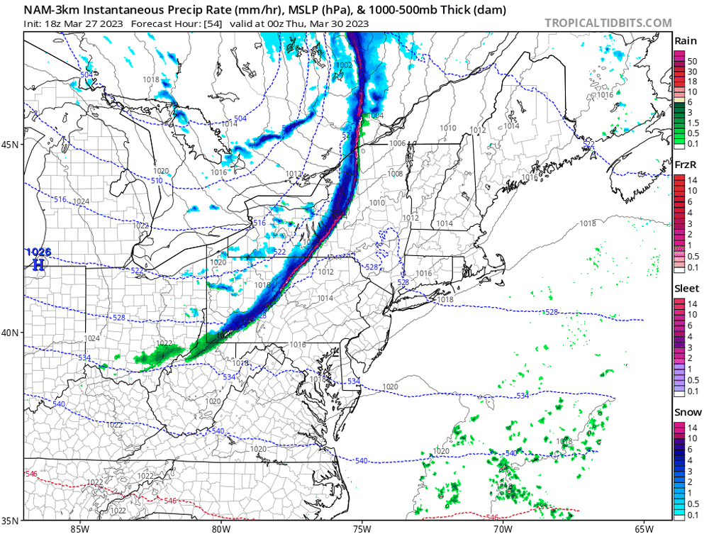
Certainly a synoptic wind threat later tomorrow, especially along and behind the front. The question is whether there are severe gusts with a line of showers just ahead of the front - the NAM is impressive but is somewhat of an outlier with that feature for now.