

high risk
-
Posts
2,588 -
Joined
-
Last visited
Content Type
Profiles
Blogs
Forums
American Weather
Media Demo
Store
Gallery
Posts posted by high risk
-
-
Things continue to look active for the late afternoon / early evening period. SPC has added an ENH to the DC-Baltimore corridor.
-
 5
5
-
-
1 hour ago, Interstate said:
I guess one storm is going to pop up over Northern Balt County... since they are the only M/D county in the flood watch
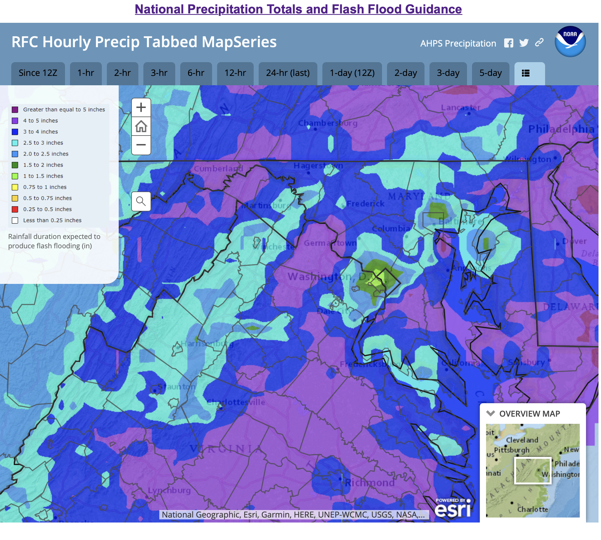
While coverage may be slightly lower in the northern counties, the main reason for leaving them out of the watch is that the flash flood guidance shows that it will take more rain up there to cause problems than it will along the I-95 corridor:

-
2
-
-
1 hour ago, yoda said:
I wasn't really counting on a tornado threat tomorrow... but LWX has it in their afternoon AFD
SHORT TERM /TUESDAY THROUGH WEDNESDAY NIGHT/...
A cold front will approach from the Great Lakes region Tuesday.
A low pressure trough of low pressure should set up on the
leeside of the mountains late Tuesday morning and into the
afternoon. Winds will increase out of the south to south-
southwest, leading to increasing warmth and humidity where
temperatures will climb into the 90s with dewpoint temperatures
punching into the lower to middle 70s. This will be the fuel for
the thunder that is expected Tuesday afternoon and evening as
the cold front approaches the region. CAPE values will rise into
the 1500 to 2000 J/kg range. The combination of this CAPE and
some added wind shear as mid-level energy sweeps in from the
northwest will get developing thunderstorms to possibly become
severe Tuesday afternoon and evening. Thunderstorms will be
capable of producing any one of the severe weather aspects such
as flooding downpours, damaging wind gusts, large hail, and
tornadoes. SPC has the northeastern one-third of our region in
the Slight Risk for severe thunderstorms Tuesday and Tuesday
night. Depending on additional model data late this afternoon
and this evening, this area may be brought farther south and
east into eastern Virginia and parts of southern Maryland. The
timing on any severe thunderstorms on Tuesday will be from mid-
afternoon through early evening, especially for the metro areas.
The actual cold front should pass through the region later
Tuesday night, perhaps an hour or two before daybreak on
Wednesday. Afterwards, the front could stall near the Virginia
and North Carolina border on Wednesday.
As I said yesterday, I like tomorrow, especially for central MD. We'll have good timing, moderate forcing, moderate instability, and decent deep layer shear. The tornado threat isn't huge, but the forecast soundings do show some turning of direction in the lower-levels, so I would agree that a tornado or two can't be ruled out.
-
2
-
 1
1
-
-
6 hours ago, yoda said:
Looks like Tuesday afternoon may be our last chance for some storms or even severe storms for the next 10 days or so -- from this afternoon's AFD:
With southerly flow and moisture return ahead of a cold front
Tuesday, temperatures will soar toward the low 90s for most
locales. PWs will increase through the day to near 1.75-2" east
of I-81 by the evening. Profiles show a decent overlap of CAPE
in the -10 to -20C layer on soundings, so there could be a large
hail threat in combination with a damaging wind threat in any
thunderstorm. There could be two rounds of thunderstorms: 1)
Along a lee-side pressure trough near and east of the Blue Ridge
and 2) With the frontal boundary itself. There is also
noteworthy shear for this time of year (40-50 kts of bulk
shear).
I will cautiously share some of LWX's optimism, as I kind of like what I'm seeing on the CAMs (I'll ignore the NAM Nest Howard County split....) in terms of storms forming along what appears to be the lee trough in the late afternoon Tuesday in an environment with with good instability and shear.
-
Here is the HREF 24h local probability matched-mean. For those who don't know the HREF, it's basically creating means and probabilities from existing hi-res models (NAM Nest, HRRR, and Hi-Res Windows). Impressive signal:

-
3
-
-
2 hours ago, caviman2201 said:
Kinda weird NWS hasn't hoisted the Flood Watch... Its a Friday in summer... lots of people are going to go down to old Ellicott City to eat and hit the bars with no clue this could potentially make their night a living hell.
There really isn't much of a threat this evening on the east side of the Potomac (and the threat to the west doesn't ramp up until you go quite a bit further west). The heaviest rain will fall much later tonight through Saturday morning. While I am also a bit surprised that a flash flood watch hasn't yet been hoisted, the last night's guidance had a lot of disagreement on the location of the heaviest rain, so I can't blame them for waiting until there was more certainty. Looks to me like there is more agreement in the 12Z guidance that is coming out, and that watch should be hoisted by mid-afternoon at the latest.
-
6
-
-
Some weak rotation and a slight hook on that cell just south of Bowie.....
-
1 hour ago, Kmlwx said:
A bit OT - but it would be really cool to have a model that was similar to the HRRR where the domain was not the entire country but small regions. Smaller region I'd assume would let it be run more frequently or at a higher resolution. Get a data assimilation system in place that allows for realllllllly good data at the start. Could be fun to see how something like that would perform as a regular part of the forecast models. I know some places (Millersville University had one) have WRFs that they run on their own...but talking more about something at the NCEP level. Though I'm aware that better resolution doesn't always mean better accuracy
")
It's in development - called the Warn on Forecast System: https://wof.nssl.noaa.gov
-
1
-
4
-
-
2 minutes ago, yoda said:
Tornado Warning for Anne Arundel and PG counties
That's a decent couplet and modest hook - I can't fault LWX for pulling the trigger.
-
The storm is turned around a bit since it's moving southeast, but yeah, there is a modest hook around Fairland.
-
1
-
-
Nice localized wind signal around Calverton
-
29 minutes ago, Eskimo Joe said:
Only the HRRR has anything decent for today and it's mostly south of DC. Would argue we all temper our expectations greatly.
While I agree that we should keep expectations in check, I'm sure if I totally agree with the details of this take. The NAM Nest has certainly hated today for most of us in multiple runs, but last night's HiResWs ARW2 and FV3 were fine. And while the HRRR doesn't like the tier of counties along the PA border, several runs have been plenty active for Montgomery/Howard/Baltimore. Shear is fine today; the question will how much of a westerly component is in the 850 flow and whether the early morning convection messes things up - both are certainly plausible fail scenarios.
-
2
-
-
Still looks like that the best chance of widespread rain for those of us on the eastern side of DC is later tonight through midday Thursday. That said, I don't like that the 18Z NAM Nest moved the axis of heaviest rain closer to the Bay.
-
 1
1
-
-
8 minutes ago, yoda said:
Kings dominion about to be smoked
The wind signal on that storm is definitely vicious.
-
4
-
-
I still like the SVR threat generally being confined to areas west of an axis that bisects DC, although it looks like it could spill eastward by a county. I do feel better, however, about chances for heavier rain for those of us on the east side of town. The heaviest rain in the late afternoon will be west of DC, but there seems to be agreement on a lot of showers on the east side of town overnight through Thursday morning.
-
3
-
-
2 hours ago, Kmlwx said:
Definitely one of the more strange sim reflectivity plots I've seen before. Still think a good chunk of the area will see precip - but I'm not sure there will be any sort of sustained severe threat for anyone in the immediate metro area.
Agreed. Looking at the various CAMs, there isn't going to be very much CAPE available on the east side of the Potomac. The best SVR risk is likely to be west of DC.
-
4 hours ago, Kmlwx said:
Worth noting - solid CIPS severe signal at 168hrs on the 0z suite.
I'm assuming that's with the strong front that looks to roll through next Monday? The frontal timing looks off so far, but we obviously have 7 days to slow it down......
-
55 minutes ago, Kmlwx said:
Seems like the front is right through the area right now - 18z analysis had it into the northern parts of Maryland. Guessing that is what's triggering a few showers?
Definitely. They're fighting the dry air from downscoping, and frontal convergence is weak, but there is likely just enough forcing along the front to get these isolated small showers. The main show is further south, where the long-lived MCS is moving into central/southern VA.
-
Just got an isolated, brief, unexpected downpour in southern Howard County.
-
6 minutes ago, Eskimo Joe said:
Uh, watch box is canceled?
I'm as skeptical as you are about round 2, especially given model trends, but I'm still surprised that they did this. The recent MD talked about the threat later this evening, but I'm guessing that the evening shift came on at SPC and decided that the threat isn't enough to keep the watch up.
-
3 minutes ago, Kmlwx said:
Hearing LOUD thunder within the past 20 mins in Colesville, MD. Maybe anvil crawlers?
Definitely electrified anvil activity. You can see very slight reflectivity in the areas where the strikes occurred.
-
7 minutes ago, AmericanWxFreak said:
Just got lightning and thunder in Columbia - odd.
Same here - just down the road. Several lightning strikes way, way removed from the rain.
-
13 minutes ago, coolio said:
DC rain shield? This storm coming in from the west looks like it is touching the beltway and doing straight down, southward turn.
There is discussion about this in the Severe thread. CAPE is much lower east of the Potomac, and storms are not surviving as they approach the river. They're turning to ride the instability gradient a bit.
-
1
-
-
Just now, George BM said:
Just noticed that from radarscope wondering whether it was a glitch. So you heard thunder from them?
Yes. Saw the lightning, followed by loud thunder. Was not expecting that.
-
1
-
2022 Mid-Atlantic Severe Wx Thread (General Discussion Etc)
in Mid Atlantic
Posted
As long as ongoing convection to the northwest hasn't screwed up the schedule at BWI, and no other delays occur, you *should* be ok, as no guidance has storms arriving at BWI that early.