

high risk
-
Posts
3,133 -
Joined
-
Last visited
Content Type
Profiles
Blogs
Forums
American Weather
Media Demo
Store
Gallery
Posts posted by high risk
-
-
The forecasted accumulated snow depth maps are the only relevant images for this event.
-
 4
4
-
 4
4
-
-
24 minutes ago, TSSN+ said:
The area to watch
Agreed. HRRR has a pretty good handle on it, and while I'm still not totally sold on the severe threat, it's moving into a more favorable environment.
-
Friendly reminder that snow accumulation does not reflect what the model thinks will stick. It reflects the amount of QPF that the model has falling as snow. The issue of why the QPF has over 0.50" of liquid falling at the tail end of this event is, however, a fully legit question.
-
3
-
-
42 minutes ago, TSSN+ said:
Models don’t show much action today.
Yeah, this is the problem. The shear is good, but how many storms will form? HRRR pops a couple of cells, but it thinks that we're still going to the mid 80s today.
-
Well, hello HiResW FV3!
-
2
-
-
Ugh. The evening CAMs have really backed off, and the NAM Nest never liked it from the start. If this idea is correct, any severe threat may be confined to along I-70 and north.
-
 1
1
-
-
2 hours ago, Kmlwx said:
I know there's a lot of mixed thoughts about the CIG hatching - but this is probably where it is going to have a good amount of utility regardless of how confused people are.
Bear in mind that prior to the new outlooks - this map would just be a straight 2% tornado prob for us.
Yeah, I like the 2% hatched. It reflects that there right now is an overall low threat of tornadoes in this area, but if we were to get one, it could be a strong one.
-
2
-
-
1 hour ago, yoda said:
Wow... LWX went all out with a long, detailed, and excellent afternoon discussion for tomorrow
Yeah, that was impressive. I agree that there is a lot of uncertainty, but there does seem to be some consensus that the best shot at storms and severe weather tomorrow is north of I-66 in VA and Route 50 in MD. And the real threat might be another county north.
-
1
-
-
11 minutes ago, arlwx12 said:
Might (or might NOT) be a bit stormy tomorrow.
From LWX's latest AFD:
(snip)
KEY MESSAGE 1...Severe Thunderstorms are possible Wednesday
afternoon and evening.

Tomorrow`s forecast is an extremely challenging one. At this point,
there`s a wide range of potential solutions on the table, with very
low confidence in which solution will ultimately verify. Forecast
details follow below...
come visit us in the severe thread!
-
10 hours ago, Stormchaserchuck1 said:
As always, when a super warm day is initialized, models lose snow threats. They don't estimate this stuff right when it is ahead of time.
This makes no sense at all.
-
1
-
 2
2
-
 8
8
-
 2
2
-
-
2 hours ago, Nomz said:
RRFS simref eye candy. Outlier run, but it's fun to look at.
In the 00Z suite, although they differ greatly on timing and coverage every CAM other than the NAM Nest has convection in our area at some point during Wednesday afternoon in a modestly favorable environment for severe. I'd say that the initial Day 2 outlook will at a minimum keep us in a MRGL, and a SLGT isn't out of the question. The only shot at severe is with the open warm sector storms, as whatever is on the front early Thursday will be weak.
-
4 hours ago, yoda said:
SPC opens Day 3 severe bidding with SLGT risk i81 corridor west and MRGL for the rest of us
As I noted earlier, I was down on the chances, because I'm not sure what would trigger storms during peak heating. The HiResW FV3, RRFS, and ECMWF do all suggest cells in our area, however, Wednesday afternoon in an overall somewhat favorable environment, so I can't ignore that.
-
2
-
-
6 hours ago, yoda said:
12z NAM looked a lil intriguing with its soundings at hrs 78 to 84 across the region. Granted it can change next run of course and its at range... but looks like our first real chance of severe
Soundings for later Wednesday do look interesting, but what will trigger storms? Maybe there is a subtle shortwave in the flow to do something, and the ECMWF admittedly does suggest a couple of open warm sector storms, but I'm skeptical. It appears that the strong forcing won't arrive until early Thursday, the most unfavorable time of day possible for this setup.
-
1
-
-
1 minute ago, hstorm said:
For the past few days, NAM has shown DC N&E staying on the colder side of the front today, at least until evening. 12z 3k NAM seems to suggest that the boundary stays even a bit further S&W for most of the day. We’ll see. But it’s done pretty well this week and is typically good with these setups.
Agreed, and it's usually really good on this, but it can sometimes stay too cool if a bit of sun can break through on the cool side of the front. Regardless, it really looks like those of us on the east side of the river will get our max temp today at 11:59pm. Tomorrow could get sneaky warm ahead of the weak front sagging southward. The exact timing of the front is in question, which greatly affects the potential to get warm, but southern MD probably has the best chance of getting to the 70s.
-
1
-
-
On 2/21/2026 at 11:12 AM, rjvanals said:
GFS is about to be 0-4 in predicting major snowstorms for DC this winter
If we do get some warmup east of the Potomac, it will likely be very late in the afternoon. There is a good amount of model agreement that Saturday’s max temp will occur at 11:59pm.
-
1
-
1
-
-
28 minutes ago, adelphi_sky said:
Are those thunder showers out west? Or just heavy rain?
There are lightning strikes to our west, and there is good agreement in guidance for convection this evening into the overnight for at least the northern half of the region. Forecast soundings suggest enough instability for a continued threat of thunder.
-
2
-
1
-
-
2 hours ago, yoda said:
Hmmm... sneaky severe this evening?
Way too stable for severe east of the mountains, but there will be some elevated instability, so I expect some thunder during the evening / overnight, especially for areas north of 66 (VA) and 50 (MD).
-
2
-
-
4 hours ago, SnowenOutThere said:
What sort of convection is it? Elevated I assume since the temp inversion near the surface
Yes, completely elevated, but the forecast soundings do indicate some instability for parcels originating well above the surface.
-
1
-
-
Pretty good chance that at least the northern half of the area gets thunder later this evening.
-
3
-
-
Nice to see the thread ready to go for the upcoming season!
-
4
-
-
Moderate snow in downtown Silver Spring
-
5
-
-
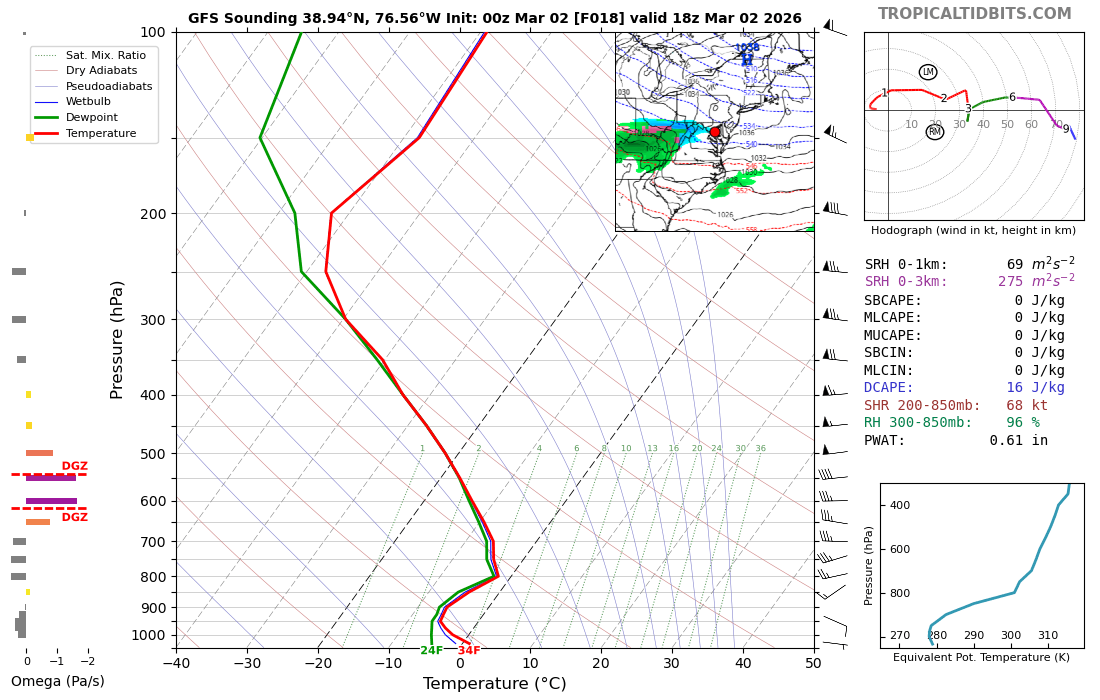
21 minutes ago, PhiEaglesfan712 said:
This really won't happen. The sun angle is too high and temps are a bit too warm for snow. If anything happens, it will probably be rain.
yeah, clearly a rain sounding.

 Spoiler
-
1
-
3
-
-
While a messy Tuesday morning rush hour has been in the cards for a while now, I'm becoming increasingly intrigued by the Monday afternoon snow event. My question is what the road temps will be like Monday after a couple of warmer days but a cold night. The NAMs and HiResW FV3 suggest that temps will only barely go above freezing tomorrow before arriving snow cools it back a few degrees. It's still tough to imagine messy roads during the daytime, but maybe if it comes down hard enough? Ultimately, it's *probably* just going to whiten grassy surfaces until you get further west and northwest, but the Monday afternoon through Tuesday morning period will be a nice reminder of winter before the big warmup.
-
6
-
-
Those of us north of DC got HRRR'ed for Monday afternoon. Notable shift north for the NAMs as well.....
-
5
-
2
-
2026 Mid-Atlantic Severe Storm General Discussion
in Mid Atlantic
Posted
It’s going to happen because I have a flight arriving at BWI that evening. But seriously, you all have nailed it: Shear will be off the charts, but early spring setups fail a lot here due to the strength of the system causing widespread showers and clouds.