

high risk
-
Posts
2,587 -
Joined
-
Last visited
Content Type
Profiles
Blogs
Forums
American Weather
Media Demo
Store
Gallery
Posts posted by high risk
-
-
One other thing, and perhaps I missed discussion of this: a few CAMs and the GFS show a period of light snow here Thursday evening with the lead wave.
-
 6
6
-
-
Surface temperatures are super marginal, so it might have some difficulty sticking on roads once we get past 8am or so. That said, the road surfaces should be plenty cold going into the event, so rates might still get the job done.
-
6
-
-
1 hour ago, WxUSAF said:
7.5F for the low so far.
Nice! I don't have that sort of precision on my station, but it is showing 6 this morning.
-
1
-
-
3 minutes ago, Terpeast said:
Big difference on the same model
The 12 km parent and 3 km nest have different diffusion, so differences in 500 evolution can and do happen.
-
 5
5
-
-
The northward shift in that run also makes us a bit warmer at the surface, which reduces the ability of the snow to stick during the daytime hours, although surfaces at least will overall be cold.
-
3
-
-
22 minutes ago, stormtracker said:
18z NAM running. Should be at 60 hr+ at around 7:45pm
correction: The actual model run will run on time as it does 99% of the time. The TT graphics processing, run on a 1984 Commodore 64, will be ready by bedtime.
-
4
-
1
-
 23
23
-
-
5 minutes ago, Imgoinhungry said:
We thinking normal operations for schools tomm? Or delays? Low of 11 tonight and negative windchills. Brrr.
.Depends whether they can clear all of the side streets and sidewalks today and give them time to dry out this afternoon before the temps plummet later. Anything that isn't dry will freeze hard tonight, so I would say that there could be delays or closings again tomorrow.
-
1
-
-
4" here in southern Howard County
-
5
-
-
Traffic maps across the region look far worse than I expected to see during the daylight hours on a holiday. Likely to look much worse when the sun sets and rates increase.
-
4
-
-
Just now, Eskimo Joe said:
I prefer a model that is too slow on eroding cold air damming. For Example, if it shows you're above freezing by 12:00 pm and we know it has a cold bias, then it boosts confidence that things will clear up in the afternoon.
I agree 100%, and the NAM Nest is that model. It's sometimes a bit too slow in eroding the cold air, but that's better than the GFS and HRRR which wipe it out way too fast.
-
1
-
-
3 minutes ago, Terpeast said:
Maybe they'll think twice about burying the NAM.
The NAM struggles with synoptics for sure, but once it figures those out, it's pretty damn good with winter event details. And to be clear, I'm focused on the 3 km NAM Nest, as the 12 km parent is meh. There is no model better than the NAM Nest for resolving cold air damming, and while it sometimes runs too cold in the low levels when sorting out precip details, it's also really good at capturing warm layers that screw up a snow profile. The RRFS has yet to prove competence in these areas, and the HRRR isn't great either, so we will miss the NAM on some days when it's gone.
-
8
-
1
-
-
9 minutes ago, psuhoffman said:
Sounds like they’re having a hard time coming up with a quality system. Oh well.
Correct. It's really tough to generate meaningful spread from a single model core in the short range. And the struggles of the FV3 core aren't helping things.
-
1
-
1
-
-
18Z NAM (both 3 and 12 km) looks better because the snow gets more impressive earlier, but it also slows things down much faster Monday night, and the highest totals are northwest of the I-95 corridor
-
9
-
-
2 minutes ago, SomeguyfromTakomaPark said:
Majority of the precip is before we lose the thermals though.
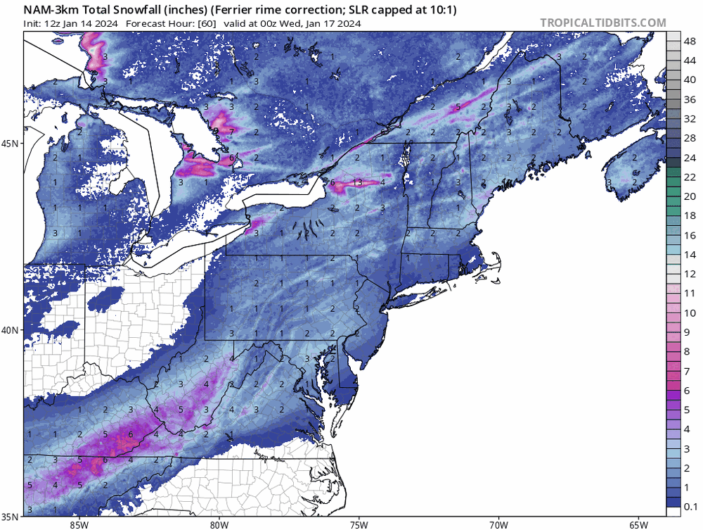
Agreed. While this could still potentially move further in the wrong direction (and to be clear, I think we'd be good for a while regardless), the NAM Nest is fine for snow for most of the area through the prime portion of the event. In fact, the "Ferrier" accumulation, which is completely driven by the model microphysics, has a nice accumulation for many, indicating that the model has the hydrometeors falling as snow for plenty of the key hours, even if it turns to some light freezing rain Tuesday morning:
-
17
-
 1
1
-
-
1 minute ago, psuhoffman said:
A high res ensemble seems like a good idea in theory. Have they tried to develop a system that actually works?
The RRFS (Rapid Refresh Forecast System, a 3 km ensemble, is being developed. It hasn't been easy, because it has to be at least as good as the HREF to replace it, and it's far easier to get meaningful spread from a a system with multiple different models (HREF) than a system with just a single model core.
-
1
-
2
-
-
31 minutes ago, psuhoffman said:
Thanks. So essentially the sref is the last guidance of the previous cycle. Some think it’s a preview of the next cycle lol. Frankly with so many high res models now, NAM12, nam3, rgem, hrdrps, fv3, ARW1, ARW2, HRRR, Im not sure how much the SREF is going to tell us we didn’t already know. Especially given their outdated since I don’t think they’ve been updated in a long time.
That's the key point. It's badly out of date and wasn't a great system when it was "in date".
-
1
-
1
-
-
6 minutes ago, psuhoffman said:
Is the 21z SREF run off the 18z models?
YES
-
1
-
-
46 minutes ago, jayyy said:
For sure. Gotta think there’s another NAMing inbound since it’s the Nams ensemble.
The main focus is on us getting NAM'ed, but I'll just make a quick point that this isn't really true. The SREF is a mix of 13 ARW and 13 NMMB runs using a mix of RAP, NAM, and GFS initial conditions (and multiple physics). Yes, half of the members have the same model core as the NAM, and roughly 1/3 use NAM initial conditions, but it's not a NAM ensemble.
-
5
-
1
-
-
Just now, peribonca said:
So it looks like we're going to get a few periods of flurries and light snow over the next 3 days prior to a possible real storm at the end of the week. Not amazing but at least it'll feel wintry for the first time in years.
Plus a heavy snow squall Sunday morning
-
5
-
-
24 minutes ago, clskinsfan said:
HRRR with a pretty nice squall line tomorrow. For those that are into that kind of thing. Maybe we can snag a quick half inch from it?

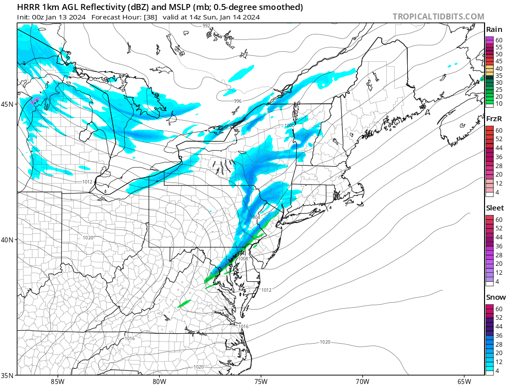
This was discussed last night. It's not just the HRRR - every hi-res model has a line of snow squalls rolling through the area Sunday morning. Yeah, it might be rain drops for a few minutes, but it will quickly turn to a fun burst of snow.
-
7
-
-
The NAM Nest, HRRR, and FV3 and ARW2 HiRes Windows all joined the "narrow line of snow squalls on the arctic front" party for Sunday morning. Great signal! Example from the HRRR:

-
15
-
-
1 hour ago, Kevin Reilly said:
This model has been very good now let's see how it does tranitioning from warm and wet to cold and snowy!
For clarification, I just want to note that the NBM is not a model like the GFS, HRRR.... It's the National Blend of Models which blends and calibrates guidance from actual models. It accounts for the solutions among deterministic runs and ensemble members from numerous modeling systems around the world and is designed to capture signals of consensus. So, it's pretty nice to see it show a healthy signal for next week at this range.
-
20
-
6
-
-
Watching that line build over northern VA. It's easy to ignore it given the huge swath of intense rain departing to the east, but if you look closely at the CAMs, there are signals for some isolated heavy cells moving across the area over the next 3-4 hours. Temperatures should rise ahead of it, and there is a little bit of progged instability..... Curious to see if these things are anything more than brief heavy rainers.
-
7
-
 1
1
-
-
22 minutes ago, Jandurin said:
Flooding should be bad enough to warrant schools closing early
The point, though, is that the heaviest rain and flooding potential are indicated by all guidance to arrive after schools would have dismissed at the regular time (and bus routes would have ended).
-
4
-
Jan 19th Snow on Snow: the this always works until it doesn't thread
in Mid Atlantic
Posted
I don't think that this is a storm for which the super generous Kuchera ratios will work well. It's not super cold, and lift does not appear to be maximized in the DGZ. With cold ground and temps a few degrees below freezing, this might be one of those cases in which the 10:1 maps actually work pretty well.