

high risk
-
Posts
2,587 -
Joined
-
Last visited
Content Type
Profiles
Blogs
Forums
American Weather
Media Demo
Store
Gallery
Posts posted by high risk
-
-
Just now, Eskimo Joe said:
Got a screenshot or two for those are mobile?
Looking forward to seeing what this looks like on the NAM Nest once we get into range.
-
 3
3
-
 3
3
-
-
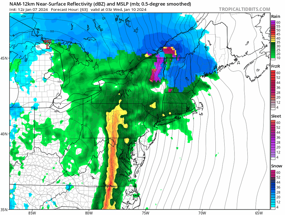
The 12 km NAM has a nice depiction of the intense, forced rain band that will accompany the front later Tuesday evening. This will potentially be our greatest chance to mix some of the stronger winds just above the surface down to the ground. I'm very modestly hopeful of hearing thunder.
-
3
-
-
1 hour ago, clskinsfan said:
I am talking about the NAM.

For future reference, that's the 12 km NAM, as also known as the parent. The 3 km NAM Nest is usually labeled as either the 3km or the nest.
-
1
-
2
-
-
5 minutes ago, wxmvpete said:
Something that has been on my mind, especially for those to the west maybe more along Parrs Ridge, is are we seeing guidance bring that warm nose in as-advertised, but also not capturing just how cold the low levels will be once they wet bulb initially? I can see an avenue that still certainly result in a less snowy regime. But if those N-NE winds at low levels holds, some areas may end up more icy than just rain. That will be worth watching on the CAMs in future runs. And the CAMs will be more included in the WPC PWPF now that we are inside of 60 hours for this event.
Totally agree about the low-level temps. The EC and Canadian bring much of the I-95 corridor into the upper 30s by Saturday evening, but the NAMs this evening keep that area around 33. With the north-northeast wind direction shown on most guidance, a quick rise into the upper 30s while precip is falling seems unlikely.
-
3
-
2
-
-
The NAM 10:1 maps look huge even along the I-95 corridor, because even after the precip type maps show rain, the model microphysics are generating sleet which is going into the snow water equivalent tally.. Here is a sounding from the "rain" area:
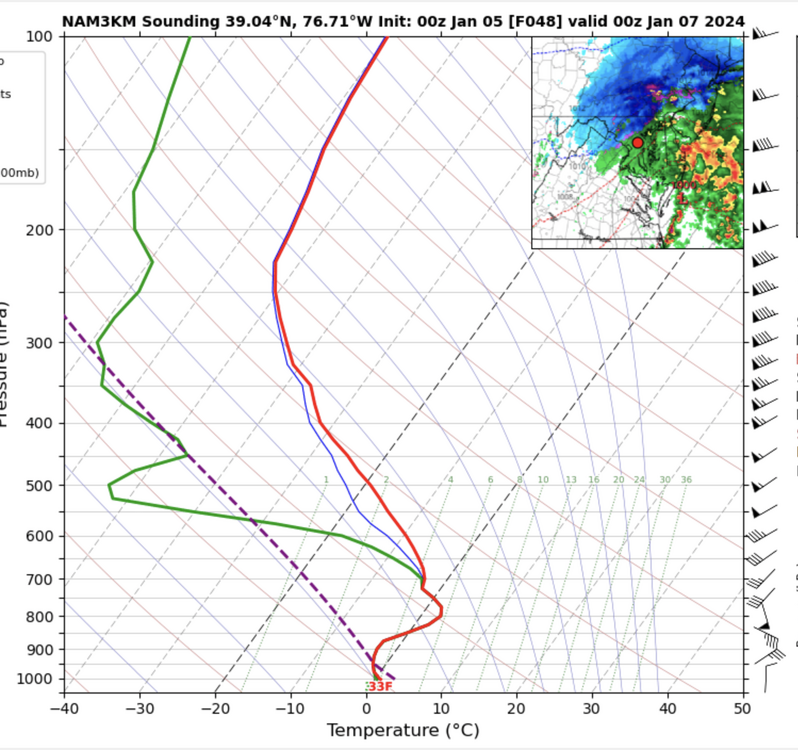
That's heavy sleet. Not saying that the thermal profile will be correct, but it explains the generous 10:1 totals.
-
5
-
4
-
-
6 minutes ago, WxUSAF said:
Snow depth is good to check against in marginal situations like this but I’m not sure I’ve ever seen actually accumulations that match snow depth forecasts. Even the December post-deluge changeover beat the snow depths by like a factor of 2.
That's fair. The depth field is underdone in events with warm ground going in, marginal temps, and good rates. But it's a strong alternative to 10:1 maps when you have a lot of sleet (or other mix) or poor rates with marginal temps. In events that argue for rates overcoming temps, a blend of the 10:1 and snow depth, with a solid lean towards the depth, often works well.
-
4
-
-
2 minutes ago, psuhoffman said:
@high risk example


Thanks for this example! WB must be making their own determinations about how much QPF is going into each precip type. As I mentioned, the only "accounting" in the actual models (RAP/HRRR excluded) is a snow water equivalent bucket that counts whatever fraction of the falling precip is snow or sleet. It's "good" in that the WB approach wipes out the sleet and also the accumulations when the profile doesn't support pure snow, but they're trying to match precip the accumulates over a longer period of time with the instantaneous precip type, so that won't always work very well.
Ultimately, the RAP/HRRR do things the right way: they have separate buckets for each precip type and output each of them. It removes the guesswork. This approach will be used in the new RRFS, and the GFS is going to adopt it too.
-
4
-
4
-
-
1 minute ago, psuhoffman said:
TT seems to count qpf other sites deem non snow. It’s always crazy generous on the south side compared to all other outlets.
Assuming you're talking about 10:1 maps? That's really odd, as the models generate a water equivalent of snow field in mm that should simply be converted to inches and multiplied by 10. The only thing that they could be doing is trying to make their own determinations about how much of a period of QPF is snow, but that would involve a lot of assumptions on their end that would not work well. I'd be very interested in seeing an example.
-
4 minutes ago, usedtobe said:
Personally, in these really marginal temp event, I use the snow depth product. It's more conservative with amounts which is a good think. If it's really cold other snow maps are probably preferable. The GFS snowdepth product from the 18Z run.
Good to see you here @usedtobe! I'm also a huge proponent of the snow depth product in these marginal temperature events, but I like to throw in the caveat that it will be underdone in these type of events if the rates are really good.
-
6
-
-
28 minutes ago, SnowDreamer said:
If the code that accumulates snow is inside the model and driven by physics, then why are snow accumulations so wildly different on different websites? Presumably they all use the exact same data from the model.
Do you have an example? The 10:1 maps should be the same everywhere. The snow depth maps should be too, except that while Tropical Tidbits only counts positive changes in depth (i.e. they ignore when the amount goes down due to melting or compacting), while others may count any change. Even the Kuchera method should, in theory, yield the same result across sites.
-
1
-
-
21 minutes ago, WxUSAF said:
I love how on TT, the 3k NAM keeps accumulating snow even after the flip to rain.
That's because the code that accumulates snow is inside the model and is driven by microphysics, and the code that generates precip type is outside of the model and is driven (mostly) by the temperature profiles.
-
3
-
4
-
-
Now would be a good time for a few quick reminders about model snow accumulations:
- Most of the American models (I'm not entirely sure about our international friends) generate a water equivalent of snow. It's then up to the user to apply a reasonable snow-to-liquid ratio. Some sites compute one (i.e. Kuchera), but that tends to be somewhat generous. 10:1 is the most commonly displayed field, but while it's a nice one-size-fits-all approach, it's not always applicable to the temperature profile. The key here is that if you're looking at a GFS 10:1 map in a marginal temperature situation, don't say that the GFS shows 6-8 or whatever amount. It doesn't. Mentally adjust that "starter map" as needed.
- Along those lines, the water equivalent of snow is not always a measure of how much snow can accumulate. Sleet goes into the same bucket as snow, so an all sleet event will still show large water equivalents, and a 10:1 map looks absurd. Even an event with 1" of liquid that consists of a 50-50 mix of rain and mangled snowflakes will show 0.5" of snow water equivalent. If you use a 10:1 map, you get 5", even though the model never really thought that anything would stick.
- Those issues with sleet or snow that won't accumulate due to warm ground or marginal temps are largely handled by the snow depth field which is the actual amount that the model thinks will be on the ground. 10:1 and snow depth maps look amazingly different in sleet events, as they should. But they also often look different in events with marginal temps or very warm ground. The snow depth maps are usually good, but they do tend to underestimate when the ground is quite warm heading into an event or if big rates overcome marginal temps. In those events, a blend of the 10:1 and snow depth maps is often a good call.
- RAP/HRRR actually predicts accumulations (with a temperature-dependent SLR) that account for compacting and melting, although they're not displayed on Tropical Tidbits.
- The NBM computes SLRs for each member with snow, and the system overall uses a lot of inputs (including ensembles) and is calibrated, so it's worth a look. Remember, though, that it won't respond immediately to big shifts in guidance.
Knowing the limitations of the products you're examining helps to limit the confusion, frustration, and ugly analysis. Thanks for coming to my TED talk.
-
16
-
20
-
-
11 hours ago, WxUSAF said:
I agree to 72 hours or so, but there also is a tendency for follow the leader with the ops and ensembles lately. Maybe someone like @high risk or @dtk can speak to studies of how nondispersive they seem to be in recent years.
The last GEFS upgrade (Fall 2020) switched the system to the FV3 model core and among many improvements, the spread was increased (as intended), and the extra spread was largely meaningful spread. That said, the GFS had a fairly significant upgrade (to version 16) after the GEFS upgrade, and the GEFS has not received the corresponding update. Overall, it still feels to me like the GEFS responds to GFS trends more than it should, consistent with the observation by@WxUSAF that there seems to be an element of follow the leader.
-
2
-
2
-
-
GFS temps are at or above freezing for a good chunk of the event. Snow of course can absolutely accumulate at those temps with good rates, particularly if it falls after dark Saturday night, but 10:1 is likely to be too high for the SLR.
-
6
-
1
-
 1
1
-
-
6 hours ago, pazzo83 said:
i don't think you are quite grasping what he's saying. all weather models are probabilistic models that factor in historical data, current observed data, and the understood mathematics that describe the atmosphere. obviously it could be wrong because models are often wrong. but let's look at the inputs again - unless you are arguing that one of those inputs was somehow corrupted for this particular model run, it is telling you that the most likely outcome is what is shown (with rain basically everywhere). i think that is where the concern lies - it is outputting an outcome that is not what one would've expected in years past, meaning it is incorporating some sort of fundamental change in terms of those inputs. I don't think the math has changed wildly (if only to improve model precision), so...
This isn't how standard NWP works. Historical data plays no role: you have equations that represent all relevant processes, you create an initial state based on observations, and you integrate the model. Historical data *does* factor in for AI/ML approaches, but if you're just looking at a standard GFS forecast map, it doesn't know anything about years past.
-
5
-
2
-
-
Worth noting that the two CAMs that are run to 60 hours (NAM Nest and HiResWindow FV3) both show a burst of snow showers very early Tuesday for those of us on the east side of the Potomac.
-
6
-
-
1 minute ago, WxUSAF said:
I thought that was last winter? I think the GEFS has been upgraded. @high risk?
The GEFS was indeed upgraded to use the FV3 core in 2020! https://www.emc.ncep.noaa.gov/users/meg/gefsv12/
It doesn't, however, have the changes that were made to the GFS in Version 16 in 2021.
-
12
-
-
9 minutes ago, DarkSharkWX said:
HREF has many of us NW of 95 switching to snow before midnight, not sure how good it is w winter
Before midnight? I guess it depends how you define "many of us NW of 95", but it looks to me to show that occurring just after midnight. The HREF is just averaging the HRRR, NAM Nest, and Hires Windows - the most recent 2 cycles of each.
-
3
-
-
29 minutes ago, psuhoffman said:
If the banding being shown does materialize I think a compromise between the Kuchera and the depth maps are more likely.
Yeah, I'm the biggest advocate for the depth maps for events with warm ground and marginal temps, but those maps can run low IF the rates are legit (and it helps if the snow falls at night)
-
4
-
2
-
-
2 minutes ago, stormy said:
Searching for a better short range model than the NAM as suggested by psu.
Lets try the NDFD
I could buy this.
NDFD is the gridded NWS forecast
")
-
1
-
 3
3
-
-
1 hour ago, psuhoffman said:
Hrrr 18z looks significantly more amplified v 12z. Nice trend. NAM looks a mess at 18z which isn’t uncommon it’s bouncy AF.
Which brings me to…what is NCEPs high res short range flag ship model of choice now anyways??? They stopped updating the NAM and SREF years ago. Which was fine they’re ancient and probably outlived the usefulness of tweaking their core at this point. But they were never replaced. The HRRR isn’t any more reliable and seems mostly ignored. The ARW FV3 I don’t think ever became operational (unless I missed that) and is largely absent in any forecast discussion. The RRFS has been in development for years and still isn’t operational. Frankly in most discussions of short range Synoptics they still talk about the euro and gfs mostly. So…what exactly is the current preferred high res short range guidance? Any of the pros in this area want to chime in?
I'll chime in, the answers (opinions??) are complicated and nuanced. The HRRR is still the flagship CAM, but it has primarily been tuned for deep convection, and I hesitate to use it much for winter weather, especially with cold air damming events. The HRRR also hasn't been updated in way too long, because all efforts are on RRFS, which hasn't come together as quickly as planned. The NAM Nest, IMHO, is still very good for precip type, although it runs a bit on the cold side and is wet, but there isn't currently a CAM that does better with cold air damming. There are 3 HiRes Windows (ARW, ARW2, and FV3) - they are all operational, but I don't love them for winter weather. The FV3 HiRes Window is particularly bad for thermal profiles.
If I had to pick a CAM for winter, I'd go with the NAM Nest, but I'd be weary of its synoptic errors beyond 36-48 hours and realize that it runs a bit on the cold side.
-
7
-
7
-
-
21 minutes ago, jayyy said:
I haven’t checked verification scores either tbh, but it certainly feels like the GFS has been pretty money over the past year or so.If we're talking about Northern Hemisphere Day 5 anomaly coefficient at 500 mb, which is generally considered the standard metric for synoptic performance, the GFS has been solidly in 4th place for most of this year, trailing the ECMWF, UKMET, and CMC.
-
5
-
1
-
-
For the love of God, please stop showing the 10:1 maps. This type of event with marginal temps and warm ground screams for the positive snow depth product.
-
5
-
2
-
 8
8
-
-
1 hour ago, mattie g said:
Canadian and Euro still want to hang that boundary around here on Halloween and then spin up a bit of a coastal on the 1st. GFS brings the front through and slides energy south and off the coast the following day.
I'd definitely like some rain, but I don't want it on Halloween again this year!
It's really tough to ignore how similar the ECMWF and Canadian are for Halloween.
-
1
-


Tuesday, January 9 Rain and Wind Storm
in Mid Atlantic
Posted
I'm not seeing the big wind threat for most of the area (except southern sections and areas along the Bay) until dinner time and especially later. Temperatures will be slow to rise tomorrow; I think we have to get into the low to mid 50s before we can really mix, and that's not going to happen until much later in the day or early evening.