

high risk
-
Posts
2,598 -
Joined
-
Last visited
Content Type
Profiles
Blogs
Forums
American Weather
Media Demo
Store
Gallery
Posts posted by high risk
-
-
2 hours ago, Kmlwx said:
Definitely one of the more strange sim reflectivity plots I've seen before. Still think a good chunk of the area will see precip - but I'm not sure there will be any sort of sustained severe threat for anyone in the immediate metro area.
Agreed. Looking at the various CAMs, there isn't going to be very much CAPE available on the east side of the Potomac. The best SVR risk is likely to be west of DC.
-
4 hours ago, Kmlwx said:
Worth noting - solid CIPS severe signal at 168hrs on the 0z suite.
I'm assuming that's with the strong front that looks to roll through next Monday? The frontal timing looks off so far, but we obviously have 7 days to slow it down......
-
55 minutes ago, Kmlwx said:
Seems like the front is right through the area right now - 18z analysis had it into the northern parts of Maryland. Guessing that is what's triggering a few showers?
Definitely. They're fighting the dry air from downscoping, and frontal convergence is weak, but there is likely just enough forcing along the front to get these isolated small showers. The main show is further south, where the long-lived MCS is moving into central/southern VA.
-
Just got an isolated, brief, unexpected downpour in southern Howard County.
-
6 minutes ago, Eskimo Joe said:
Uh, watch box is canceled?
I'm as skeptical as you are about round 2, especially given model trends, but I'm still surprised that they did this. The recent MD talked about the threat later this evening, but I'm guessing that the evening shift came on at SPC and decided that the threat isn't enough to keep the watch up.
-
3 minutes ago, Kmlwx said:
Hearing LOUD thunder within the past 20 mins in Colesville, MD. Maybe anvil crawlers?
Definitely electrified anvil activity. You can see very slight reflectivity in the areas where the strikes occurred.
-
7 minutes ago, AmericanWxFreak said:
Just got lightning and thunder in Columbia - odd.
Same here - just down the road. Several lightning strikes way, way removed from the rain.
-
13 minutes ago, coolio said:
DC rain shield? This storm coming in from the west looks like it is touching the beltway and doing straight down, southward turn.
There is discussion about this in the Severe thread. CAPE is much lower east of the Potomac, and storms are not surviving as they approach the river. They're turning to ride the instability gradient a bit.
-
 1
1
-
-
Just now, George BM said:
Just noticed that from radarscope wondering whether it was a glitch. So you heard thunder from them?
Yes. Saw the lightning, followed by loud thunder. Was not expecting that.
-
 1
1
-
-
Several recent lightning strikes over Howard/PG Counties, well removed from he precip.
-
1
-
-
26 minutes ago, yoda said:
I'm watching the storms in OH for later... that should be where our second round will be coming from, right? or the ones in NW PA?
Northwest PA, but it's worth noting that the recent HRRR and NAM Nest runs don't like our chances.
-
2
-
-
6 minutes ago, WeatherShak said:
Watch hoisted.
Yep, all the way to midnight, to account for both the ongoing activity and a possible line dropping south out of PA after dark.
-
3
-
-
This weekend air mass is going to be incredible. Multiple models show us barely hitting the low 70s Saturday, with a stiff breeze blowing. May not be a whole lot warmer than that on Sunday.
-
2
-
-
8 minutes ago, Kmlwx said:
15z HRRR is almost nothing.
So weird. The HRRR never liked the idea of a line dropping out of PA, but it did generate cells locally. It's not easy to spot notable differences in the thermodynamic environment in the model between the "good" runs and "bad" runs.
-
50 minutes ago, yoda said:
13z SPC OTLK now includes all of N VA north of around EZF and includes BWI/DC metro in SLGT risk... 2/15/15
5% TOR now includes C and W MD and E WV into extreme NW VA
Seems to be 2 scenarios:
1) Supercells form in western PA this afternoon, and a QLCS emerges and drops southeast into our area (6Z NAM Nest and 12Z ARW2). Shear is better to our west and northwest where a greater TOR threat would exist. We'd locally have a shot at damaging winds, although the system might be weakening
2) The PA storms never really get rolling, but some scattered storms develop locally late this afternoon, with some wind threat (12Z HRRR).
Of course, both scenarios for us are dependent upon clearing out the morning clouds.
-
2
-
-
27 minutes ago, Eskimo Joe said:
HRRR and NAM insistent on dropping an MCS or something like it through Delmarva and east of US 15 around morning Thursday.
Very consistent signal in model runs late this afternoon and early evening. The SVR potential seems to be low, but I'd be fine with some heavy rain and noise.
-
On a separate note, I'm struggling to figure out why the SLGT today continues to include the DC-Baltimore region, with MRGL up into southern PA. I would have expected that northern/northeastern edge to be moved back to the southwest on the 1630 outlook.
-
3
-
-
26 minutes ago, Kmlwx said:
We likely still have a few more weeks before we get into the climo period of the year when things shift over to high CAPE and extremely meager shear days. June is still meaty in the sense that we can get good shear with good CAPE to overlap. Exceptions of course can exist with potent systems and of course any tropical systems can throw more wildcards in...but past early July things get much more "pulsey"
Agreed. Peak climo here for higher-end severe in my mind is roughly May 15 - June 20 or so, but I won't argue with you wanting to extend that out a bit further. As you noted, a strong system in July/August can still get the job done, but they're tougher to come by.
-
1 hour ago, Kmlwx said:
Just goes to show you that no matter how consistent the models are on something coming through - these MCS-type events are never, ever, ever a guarantee. Add to that the stable overnight hours...it came through at really the worst time for instability...this is what you get. And honestly the NAM/NAM nest are pretty much nada for the remainder of the day as well.
You're spot on about the instability, which was always a question for this event, as it should be for something arriving here in the early morning hours. In terms of warm-season early morning convection, I can only remember a couple of legit severe events here in 20+ years.
I disagree a little bit about the consistency of the model solutions. Yes, most guidance advertised an MCC rolling through the Mid-Atlantic, but the location and details were extremely inconsistent, even hour-to-hour in the HRRR. The problem was that multiple storm complexes formed to our west and northwest yesterday and yesterday evening, and the models couldn't agree on which one would be the show here. Lots of people got super excited about the organized complex in eastern OH yesterday evening, but the models that drove a big complex through here were actually developing it from a different batch of storms in Michigan. They never handled the Ohio feature well, and I lost confidence in the setup for us as a result. I think that while the thin line that rolled through the northern areas this morning came out of that OH feature, that messed up the feature behind it, as the Michigan storms tracked more south along an instability gradient that was likely altered by the Ohio storms.
Regardless, you're completely correct that MCS activity is never a sure thing.
-
2
-
-
I throw my hands in the air on this one. The CAMs that bring an organized MCS through here tomorrow morning generate that system out of the storms currently in western Michigan. But they don't have a good handle on the ongoing storms in northwest Ohio. Could the Ohio storms end up being the show here in the Mid-Atlantic? This is so complicated, and the outcome here is dependent upon the exact evolution upstream - this explains why the HRRR keeps bouncing around hour to hour.
-
8
-
-
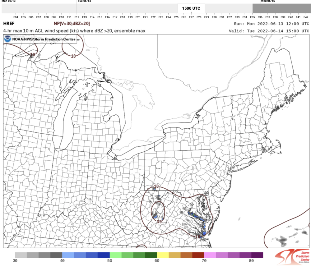
The HREF products reflect the idea among the CAMs that the chances for what's left of the MCS to bring strong winds down to the surface is fairly low (but not zero).
-
I do love how the Day 2 Outlook discussed a "weakened carcass of an MCS". That said, there is still a lot of uncertainty about how and where this MCS will evolve overnight. I'm still not overly worried at this time about widespread wind potential into the metro areas, given the poor timing and lack of instability, but these systems can certainly surprise if they develop a sufficiently strong cold pool.
-
2
-
-
1 hour ago, osfan24 said:
Well it's almost 4 pm and there is nothing on radar so that probably doesn't bode well.
It doesn't, but 18Z HRRR and NAM Nest still suggest that a cell or two is possible closer to sunset, especially in central or northern MD. And as mentioned earlier, any sustained cell today has potential to rotate.
-
1 minute ago, yoda said:
Anyone else waiting for the new Day 2 OTLK? Lol
YES!!!!! You would think that, given the delay, it's going to be "interesting".
-
1
-

2022 Mid-Atlantic Severe Wx Thread (General Discussion Etc)
in Mid Atlantic
Posted
I still like the SVR threat generally being confined to areas west of an axis that bisects DC, although it looks like it could spill eastward by a county. I do feel better, however, about chances for heavier rain for those of us on the east side of town. The heaviest rain in the late afternoon will be west of DC, but there seems to be agreement on a lot of showers on the east side of town overnight through Thursday morning.