

high risk
-
Posts
2,588 -
Joined
-
Last visited
Content Type
Profiles
Blogs
Forums
American Weather
Media Demo
Store
Gallery
Posts posted by high risk
-
-
22 minutes ago, BxEngine said:
Hi guys. Invading your forum to ask if you could send some storms to Rehoboth area this afternoon? Everything fizzled over me last night. Thx.
several CAMs fire storms along the sea breeze in Delaware by early/mid afternoon
-
 1
1
-
-
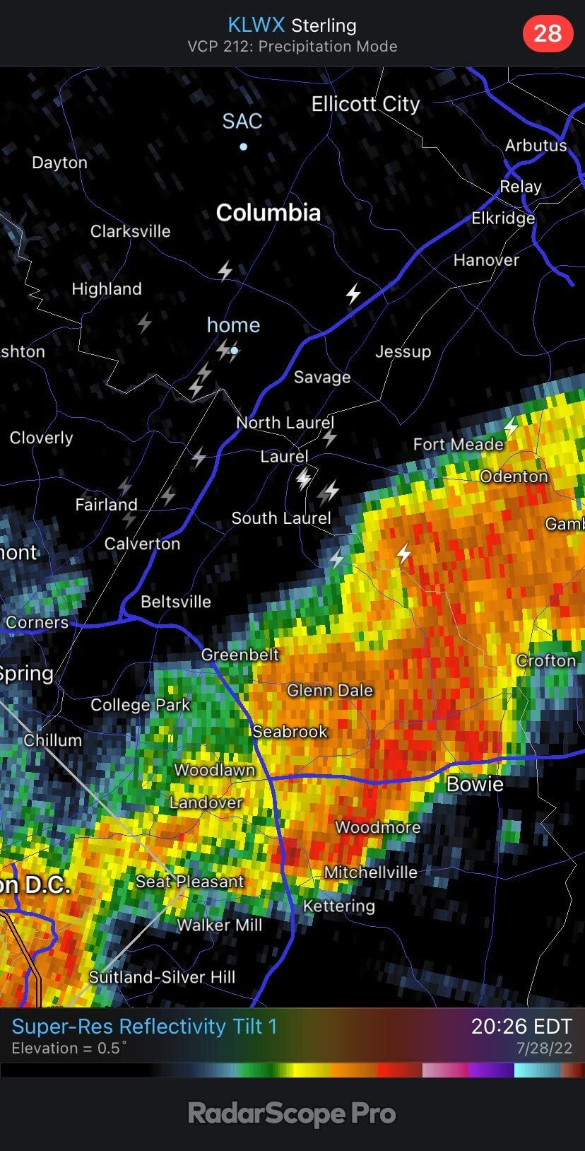
There were several lightning strikes this evening on outflow boundaries, with no rainfall or other nearby lightning, so it's not surprising that people were caught off guard.
-
2
-
-
46 minutes ago, mattie g said:
3km NAM goes CAPE crazy and drops some storms around dinnertime today.
It's the NAM. What can go wrong?
NAM Nest is doing its usual thing of having low-level dew points that are too high, which inflates the CAPE. That said, even though that solution has the most organized convection of the CAMs, most do show at least a few storms in the area later today. Tomorrow looks like the bigger deal. The HRRR is an outlier with its *low* dew points - most CAMs show widespread heavy storms in the area towards dinner time.
-
2
-
-
some significant changes so far in the 12Z suite of models: several CAMs now show a batch of heavy showers moving across a good chunk of northern VA and northwestern MD during Sunday afternoon. The HRRR even goes so far as to make it a full Sunday afternoon washout for the metro areas. Will be interesting to see if this is a one-cycle glitch for the guidance or if it's figuring out now that Sunday won't be nearly as nice of a day as originally expected.
-
4
-
-
13 hours ago, WxUSAF said:
Lots of distant thunder now behind the line. 0.08” deluge for MBY.
Got 0.26" just south of you. I posted in the Obs thread that the thunder really started cranking after the line passed, and you could see it in the lightning data. There were many strikes well behind the rainfall, including one here that was maybe 75 yards away and took out our power for 5 hours
-
1
-
-
Slight risk today includes DC at the northern edge. Consistent with that, HRRR definitely likes the area south of town.
-
4 hours ago, CAPE said:
Early next week could be interesting depending on the exact location of the stalled front that will lie to our south.
Snippet from this morning's AFD from Mount Holly-
Sunday night into Monday...The surface high weakens and a low and mid level short wave trough approaches from the northwest. As this happens, the front to our south should begin to slide northward as a warm front. Exactly how far north the front will get remains uncertain, but some models have the front as far north as southern Delmarva by late Sunday night. This has implications for our region because the pattern has several similarities to a Maddox heavy rain frontal event. In these types of patterns, there is a risk for heavy rain on the north side of a E-W slow moving front. Winds aloft are nearly parallel to the front and model soundings depict very high precipitable water values (near the 90th percentile for early August) and deep warm cloud layers. If the front does get as far north as southern Delmarva, then heavy rain could be a concern for northern Delmarva and S Jersey. I added a mention of heavy rain into the forecast, but have held off on any flood watch considerations as there remains quite a bit of uncertainty in how far north the front will be.
This is an excellent discussion. The GFS hasn't caught on to this threat yet, but the ECMWF and Canadian have.
-
3
-
-
One other odd aspect of the storm yesterday: there was no lightning as the line moved through southern Howard, but it started cranking out bolts on the back side of the storm as it moved into PG. There were numerous lightning strikes in Howard, eastern Montgomery, and western PG well after the rain had ended, including one that was way, way too close here and knocked out our power for 5 hours.

-
3
-
-
14 minutes ago, WxUSAF said:
Light sprinkles, distant thunder, grass browning.
Today was a total kick in the teeth.
-
3
-
 1
1
-
-
22 minutes ago, WxUSAF said:
Every short range meso seems to be poorly initializing the storms out west. Not sure what that implies per se…
Good point, but I *think* that it only affects the timing and not whether we get storms. If the line remains intact, I think it drives through the area in the early afternoon. If not, we wait for cells to fire to our west and move east during the later afternoon. None of the CAMs fail to move storms through the area at some point today, although there are admittedly disagreements in the amount of coverage.
-
8 hours ago, high risk said:
Right, and we have respectable shear too. My concern remains, however, that several CAMs have a dying line arriving during the morning. Most of the solutions still allow us to get hot and generate new strong storms on the outflow, but the coverage isn't what I would expect to see in the setup, and we all know that this type of scenario fails here with great ease. I'm still optimistic (honestly, I just want some rain!), but it's a cautious optimism.
I feel even better after looking at the 00Z suite, especially for those south of I-70.
-
2
-
-
1 hour ago, Eskimo Joe said:
Tomorrow looks decent. Any time we have high CAPE and a big airmass change, someone wins.
Right, and we have respectable shear too. My concern remains, however, that several CAMs have a dying line arriving during the morning. Most of the solutions still allow us to get hot and generate new strong storms on the outflow, but the coverage isn't what I would expect to see in the setup, and we all know that this type of scenario fails here with great ease. I'm still optimistic (honestly, I just want some rain!), but it's a cautious optimism.
-
 3
3
-
-
I don't see an active photos thread, so I'll put it here and apologize if I screwed up, but the sky ahead of that dying line yesterday evening was glorious:

-
8
-
-
Monday definitely has some really good SVR potential here. CAPE is extremely high in several models, and deep layer shear will be more than adequate. I'd say that we could get a day 2 ENH, but the timing on a few solutions might preclude that. The idea of a dying line of storms in the morning rejuvenating in the early afternoon could still work fine, but that scenario finds a way to screw us more often than it should.
-
3
-
2
-
-
55 minutes ago, Maestrobjwa said:
Now what caused that brief hut intense bout of wind a little while ago?
The outflow discussed in the 6 posts right before yours.
")
-
1
-
 9
9
-
-
Always fun to have a rogue MCS that the models can't handle. Box may be coming shortly for eastern WV and parts of northern VA. HRRR shows the line falling apart, but it has already held together much longer and stronger than the model has shown.
-
3
-
-
2 minutes ago, WxUSAF said:
For me too. Keep hoping for one of those popcorn showers ahead of the line to hit MBY
The CAMs have been pretty confident that new cells will form on the outflow and roll through Howard County. I suppose we could still fail, but I like our chances - I know that I also really need the rain and am not optimistic that the timing of the Thursday system will work out in our favor.
-
1
-
-
19 minutes ago, osfan24 said:
Not really seeing the flooding potential on the NAM or HRRR. Seems like things are pretty progressive.
Definitely progressive, and it was correctly noted that this partially accounts for some areas that have been very wet in the past week, but there is actually some signal for several rounds of storms:

In this example, you have a lead intense line, followed by a bit of a break, but then followed by another high-reflectivity area. And if you go 2 more hours, there is more redevelopment behind that second batch. Not every CAM shows this, but the HRRR scenario would definitely cause some flooding issues.
-
8
-
-
Looking like an active late Monday afternoon and evening, especially for those north of DC. CAPE doesn't appear to be tremendously impressive due to weak lapse rates, and shear is marginal, but downdraft CAPE looks quite good, so it's definitely at least a MRGL day with some potential for an upgrade to SLGT. One thing that stands out on the 00Z guidance is that a lot of CAMs show multiple rounds of storms, so some flash flooding potential likely exists.
-
7
-
-
26 minutes ago, Kmlwx said:
Looks stormy all of a sudden on radar
Yeah, the clouds at sunset had a convective look that suggested some forcing arriving, and the radar has really blown up. There were a few model runs today (12z NAM Nest stands out) that suggested that the weak front would light up a bit after dark.
-
Some guidance had hinted at some convective development after sunset, and radar is now blossoming to the west.
-
2
-
-
4 minutes ago, yoda said:
Looks like maybe some more storms over next couple hours looking west on radar
Yes! This has some potential to transition to a heavy rain event, mainly along and south of I-66.
-
1
-
-
11 minutes ago, Kmlwx said:
Winchester cell (now seems to be weakening a bit - (good job Cappucci lol) still has mostly an easterly component to the motion. The southern part split off and kind of took a turn to the south. Interested to see if the northern updraft just sort of peters out now as the southern one cranks.
He's completely accepting the details of the HRRR which has been pretty consistent in weakening that system. Not totally sure how much I'd trust that.
-
1
-
-
1 hour ago, NorthArlington101 said:
Surprised my area is the "easiest" to flood - just not many streams around here that tend to cause issues. I guess that isn't exactly what this map is getting at, but there are only a few areas in N Arlington that I think of as particularly flood-prone.
The map takes into account how much rain has fallen in recent days, and that big rain Friday night in the Arlington-Bethesda corridor has really lowered the rain totals needed to cause problems there. There will certainly be regions within the higher threat area that are far lower risk than others, but it's accounting for the general threat.
-
1
-

August Discobs 2022
in Mid Atlantic
Posted
Right. Instability is important, but Precipitable Water is a better driver of flooding rains than CAPE.