

high risk
-
Posts
2,587 -
Joined
-
Last visited
Content Type
Profiles
Blogs
Forums
American Weather
Media Demo
Store
Gallery
Posts posted by high risk
-
-
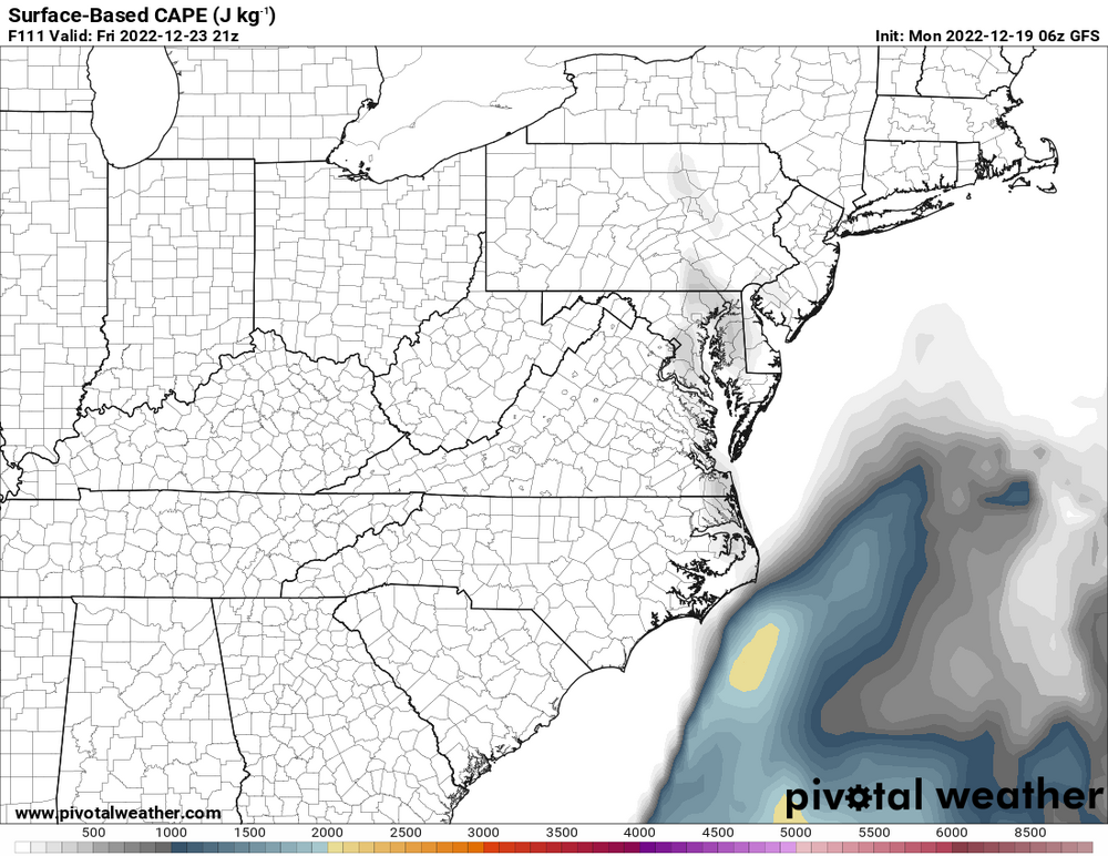
A period of anafrontal snow is definitely on the table. It's also worth watching to see how warm we get ahead of the front and the timing. GFS right now actually shows some instability for areas east of the Potomac, and with intense winds above the surface and strong shear, a low-topped convective line with damaging wind and perhaps a few brief spinnies would be possible.
-
 8
8
-
-
When the NAM Nest loses the low-level cold air really quickly, you know it's not going to be a huge deal.....
-
4
-
-
15 minutes ago, Kevin Reilly said:
One word sleet.
That's not correct. The snowfall includes sleet, so those 10:1 maps are useless in any type of mixed event. The map being shown, though, is the change in snow depth which correctly applies a very low ratio with sleet. I'm not saying that this GFS map will verify - just saying that it's not the same issue as with 10:1 snowfall maps.
-
4
-
 6
6
-
-
58 minutes ago, WxUSAF said:
^even that snow depth map seems sketchy here, but clearly a trend to colder initial conditions in the last 24hrs. 2 rules of thumb to keep in mind in this sort of scenario:
1. Surface temps will stay cold longer with CAD
2. Low/mid levels will get eroded faster than expected.
3. See rule 1, and the GFS always erodes the surface cold air too quickly.
-
8
-
1
-
-
Pretty clear trend in the guidance for a further west track which will knock down rain totals for those of us along the I-95 corridor. It does, however, open the door for a TOR threat, although instability may be too meager to take advantage of the very strong low-level shear.
-
2
-
-
4 hours ago, Kmlwx said:
I'm a little more in today and less meh - but still pretty meh.
The latest (06z) NAM nest looked decent. CIPS had a bit of a signal as well...at least as much as you could expect off-peak season. SREF even paints some sigtor ingredients in our region tomorrow on the 21z frame.Yeah, the timing is better, and instability therefore looks ever-so-slightly better. There will pretty clearly be a line of strong convection just ahead of the front. Whether it will contain lightning or be surfaced-based is unclear. Some of the CAMs even suggest some discrete cells in advance of the line. The shear is very strong, and some of the models even suggest some healthy low-level shear, so this event certainly warrants some watching.
-
2
-
-
3 hours ago, Kmlwx said:
As is common in these out-of-season events...the NAM and NAM nest favor south and east of the metros for any enhanced activity.
meh.Yeah, definitely looks better south and east of here, where the better instability will reside. A slightly slower system could, however, change things a bit.
Pros: good wind fields including some favorable hodographs, good surge of low-level moisture
Cons: limited heating leading to crappy lapse rates and very limited CAPE, no real height falls of note (the trough lifts to the northeast, which also explains why it won't be very cold behind the front)
-
1
-
-
Looks like the outflow from the northern line really disrupted the primary line arriving from the west.
-
Huge severe warning box to the east of that line segment. Certainly looks like growing potential for a long-track swath of damaging winds.
-
1
-
-
Sunday is potentially interesting around here with good timing for the next front and fairly healthy deep layer shear in place. The limiting factor is instability, especially due to fairly low dew points. The HRRR is less enthused about the potential, but as usual, it has by far the lowest dew points among the CAMs. Other CAMs are more moist, and there are some impressive simulated reflectivity forecasts (hi there, 6Z NAM Nest!).
-
4
-
-
All of the obvious caveats at this range of course apply, but besides the deterministic GFS and EMCWF agreeing on the idea of a storm and a pattern than would pull it hard north, the ensembles at that range also support a synoptic pattern that would pull any Gulf storm to the north. Certainly worth a look for now.
-
12
-
2
-
-
Time to update the max temps for today. Temps soaring ahead of the front.
-
13 minutes ago, George BM said:
I think he meant that he's surprised that we are NOT under a Severe T-storm Watch w/ a SLGT risk from SPC based on the activity that he's seeing in the region.
Ah, that makes sense - I misinterpreted. As I mentioned in the SVR thread, I thought that a SLGT was possible, but the MRGL may work ok. I do expect several warnings and a handful of wind reports (and an outside chance of a brief TOR).
-
20 minutes ago, Eskimo Joe said:
Kind of surprised we aren't in a SLGT with a sever t'storm watch box.
Is there a box out?? I haven't seen one....
-
23 minutes ago, Kmlwx said:
Yeah some of these cells have the mini supercell look.
Hodographs definitely support supercells, although low-level shear *appears* to be insufficient to actually get rotation to the ground.
-
No doubt that we could certainly get a low-topped event in the next 2 months, but for now, today's storms seem to have initiated ahead of schedule. NAM Nest is further south, but the HRRR has been pretty consistent with the greatest coverage around DC and points north.
-
2
-
-
Last hurrah for this thread?? Pretty clear in the CAMs that strong convection will form later Monday afternoon, but there is disagreement on location, timing, and coverage. Regardless, shear will be more than adequate, and instability overall looks to be sufficient (and somewhat impressive on the latest NAM Nest and HRRR runs). The MRGL is certainly warranted (as is the 2% TOR, although low-level shear might be too weak), and I would not be surprised if this ends up as a SLGT.
-
3
-
-
already up to 1.1" in southern Howard County at 10:30 AM
-
Flooding a likely concern on Sunday:
-
5
-
-
Got close to 0.6" in the heavy showers that rolled through Howard County at dinner time.
Some very solid model consensus for a more widespread area of heavy rain for the early morning hours into rush hour.
-
4
-
-
4 hours ago, WxUSAF said:
Mesos seem to be in lockstep with a line moving through the metros between 6-8pm. Agree with @high risk, just hoping for some decent rain.
The 12Z guidance went back to having several CAMs ripping the line to shreds as it arrives.
-
7 hours ago, yoda said:
Last chance severe for a while
I want to be intrigued by tomorrow, but at this point, I'm just hoping for rain. The shear is very marginal, but it looks like there will be some modest instability and a decent amount of downdraft cape. The simulated reflectivity forecasts are all over the place, but there may be some agreement on a weakening line approaching the metro areas by early evening, possibly intensifying a bit over the eastern burbs.
-
1
-
-
LWX ignored some decent signals in the CAMs for convection today......
-
1
-
-
1 hour ago, mattie g said:
Not sure about that. The radar is the proverbial Christmas Tree right now with boundaries all over the place. I think we see constant pulsing and reforming of storms for quite some time this afternoon/evening with lots of 2-3" reports.
Right. Instability is important, but Precipitable Water is a better driver of flooding rains than CAPE.


December 22-23, 2022: Warm Rain to Arctic Chill
in Mid Atlantic
Posted
While some displays are wonky, the GFS (and the other NCEP models) internally do track precipitation at every time step, and if it's falling through a thermal profile that supports snow (or sleet), it will be tallied into the snow bucket. Algorithms, based off of temperature profiles, are used to compute instantaneous precip type, but if we're seeing snow accumulation output, the model integration has precipitation falling into a column supporting either snow or sleet.
It gets dicey because the "snowfall" is a liquid equivalent, and users have to apply a ratio, and we all know that the commonly-used 10:1 is often not representative. It's worth noting here, though, that the accumulated snow depth field looks similar to the 10:1 maps. so the model is legitimately accumulating snow on the ground.
To be clear, the GFS might be totally wrong with the idea that significant anafrontal precip will fall in this event. But the snow on the GFS maps is not due to weird post-processing.