

high risk
-
Posts
2,587 -
Joined
-
Last visited
Content Type
Profiles
Blogs
Forums
American Weather
Media Demo
Store
Gallery
Posts posted by high risk
-
-
The axis from Rockville down to Manassas just lit up!
-
1 minute ago, nw baltimore wx said:
I've found the hrrr to be pretty accurate this spring and early summer, at least in my vicinity. I'm assuming the hrrrx has better overall verification scores?
yes, but the HRRR has a high bias for precip/reflectivity. The HRRRX brings that down, but in the process of eliminating some of the false alarms, it occasionally loses a "real" event.
-
 1
1
-
-
Just now, MN Transplant said:
Haven’t had a drop of rain in a week. Hope the HRRR is onto something for tonight.
the HRRR looks really good tonight, especially for the western side of DC. It's interesting, though, that the HRRRX (which becomes the HRRR next week) is not nearly as excited. Radar seems to suggest that the operational HRRR is on the right track, but we'll see.....
-
1
-
-
NAM3 and HRRR both want to develop a few storms along the I-95 corridor by early afternoon - let's see if they are on to something.
-
wind profiles are progged to be fairly decent as we approach evening.
-
16 minutes ago, yoda said:
Good call today @high risk
Thank you. The transition from SVR to flooding occurred a little earlier than I was thinking, but the excellent hi-res guidance definitely steered me in the right direction.
-
I do like seeing the HRRR get a line into our area, and the forecast soundings suggest that it would have severe potential. But one threat that appears more emphatically in the HRRR is significant rainfall from training convection over locations north of the DC Beltway.
-
2 hours ago, yoda said:
Looks like storms will be coming from our NW or N tomorrow... which is a bit odd. Though I believe @high risk liked tomorrow?
I do, as the NAM3 wants to bring an organized line in from the north into an environment with strong instability (due to impressive lapse rates) and modest deep layer shear. The shear is certainly better further north, but it would be sufficient this far south IF the extreme instability is realized.
-
1
-
-
4 minutes ago, yoda said:
SPC new 1730 DAY 2 likes PA into NY into New England
The wind fields up there are better, so I can see what they've highlighted that area, but we're going to have better instability (4000 sfc-based cape, per the NAM), and the CAMS have a nice squall line signal here too, so I'm perfectly fine with being in "only" the slight risk for now.
-
1
-
-
1 minute ago, andyhb said:
That EML for tomorrow looks absolutely nasty.
You''re all getting better severe than I got on my Plains trip lol.
I know. I was in Norman last week, and I've returned now for what will be 4 straight days of impressive storms here (and 5 of the last 6 days).
-
what's crazy is that the overall setup for later Tuesday actually looks as good or even better. Could be intense squall line (avoiding overuse of the D word), part 2.
-
4
-
-
As has been noted, it's fascinating that the HRRRX just has some scattered (although potentially svr) cells, while the ops HRRR crushes us. The HRRRX is replacing the HRRR in June, and had there not been some delays, it would have become the operational HRRR by now.
-
1 hour ago, yoda said:
18z NAM supercell and sig tor composite hitting DC area hard 00z TUES... interesting
The 00Z NAM3 likes 00z Wednesday, with really volatile environment progged for our area.
-
1
-
-
28 minutes ago, yoda said:
02z HRRR brings a large complex through the region between 08z and 11z while 00z 12km NAM and 00z 3K NAM have basically nothing
while you're totally correct that the strongest signal is in the HRRR, the NAM3 does have a system arriving around the same time - it's just not quite as organized or expansive.
-
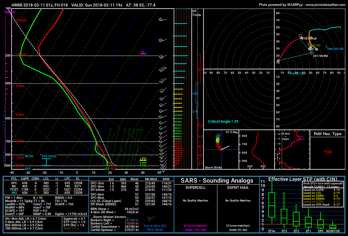
13 minutes ago, high risk said:
uh, have you looked at the upstream radar?
sorry about that. I thought I was replying to a different post (that I think the poster deleted) that questioned the need for any watch. Your question was perfectly legit. I wasn't expecting a TOR box either, but the supercell composite values in that area are actually impressive.
-
1
-
-
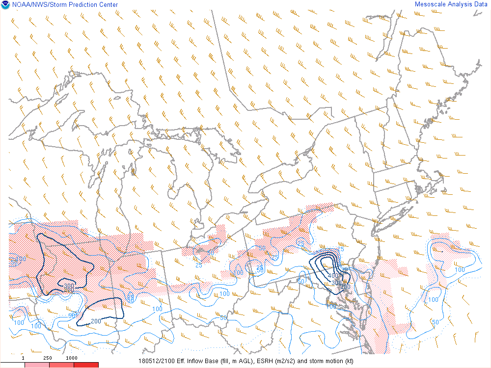
Helicity is maximized over north-central/northeast MD, so I do understand why they went with the tornado watch instead of the severe watch.
-
27 minutes ago, alexderiemer said:
I am shocked they went with a tornado watch
Sent from my SM-G892A using Tapatalk
uh, have you looked at the upstream radar?
-
After being on the southern plains for a week and not even seeing lightning there, I'm ready for this! But, I'm still totally unsure how this will evolve. The best signals in the CAMs are still for southeast PA and far northeast MD. Deep layer shear is terrific, and as has been noted previously in this thread, lapse rates are impressive, so the hail/wind threat is legit. That said, low-level shear is weak, so I don't think that a good tornado threat is shaping up.
For DC metro, the CAMs are all over the place, but the most consistent signal appears to be for the late evening hours. Maybe something will go earlier on an outflow boundary, and some guidance has some healthy storms moving through very late at night, so nailing down the time window is unusually complicated.
-
3
-
-
The CAM signals for later today are inconsistent, but some do get some decent cells into our area. As noted above, the profiles may support some damaging wind threat. But wow, check out the shear profiles up in VT for later today - remarkable. If they had a little more instability, it would be a MDT risk day. When northern New England gets into the SVR threat before our area does, it's time to wave the white flag.
-
1
-
-
Newest NAM3 still wants to develop a forced line of convection right on top of the DC Metro area during the late morning, with it looking decent for the east side of the area and into northeast MD and the eastern shore. The HRRR brings the overnight convection further east and kills it late which seems to inhibit better development in our area during the morning. The HRRR would be a big whiff; the NAM3 isn't great, but areas to the east could certainly see some stronger wind gusts.
-
500-750 j/kg of sfc-based cape seems doable for Wednesday morning, and the shear looks good, with strong wind fields in place through the column. With the strong forcing, I expect a squall line as opposed to discrete cells, with a decent wind threat. The NAM3 seems to show this well, as I expect that we'll end up with a slight risk at some point. The risk can go to enhanced if we end up with greater instability.
-
2
-
 2
2
-
-
48 minutes ago, George BM said:
Probably WAY overdone but lol hrrr for tomorrow afternoon.

There is little doubt that shear tomorrow afternoon will be fabulous; it's a question of whether we can have any src-based instability. Both the HRRR and NAM3 suggest small amounts of cape; the chances of severe seem to be low, but they're likely non-zero.
-
1
-
July Discobs Thread
in Mid Atlantic
Posted
liking the squall line forming over southern PA/northwest MD. fits well with the NAM3.