-
Posts
2,596 -
Joined
-
Last visited
Content Type
Profiles
Blogs
Forums
American Weather
Media Demo
Store
Gallery
Posts posted by high risk
-
-
marginal risk for areas just south of DC Friday. With the front now likely to be much slower to move through the area, there is the opportunity for low to mid 60s dew points to return. Shear will be strong - it's just a matter of how much instability can develop. It's very possible that much of the area ends up in MRGL (with a non-zero chance of SLGT) on Friday.
-
88/70 at BWI last hour.
-
storms struggling south of the Mason-Dixon line, but it's a wedgefest in northwest PA. Ok, that's going overboard, but there has been at least one confirmed large tornado up there, and new warnings have now been issued in the Willamsport area.
-
-
4 hours ago, EastCoast NPZ said:
12z seems to like the chances.
Another miserable run. Enjoy the next 72 hours.
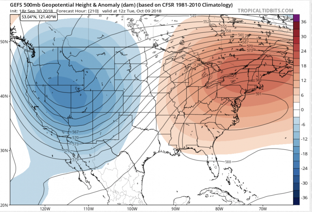
There seems to be fairly good agreement in a trough coming in from the Pacific merging with the tropical thing coming out of Baja, forming a healthy sfc low in the west next week, forcing a strong ridge over the east. The 500 pattern would support 90+ here, but perhaps the wet ground will keep us a little lower. Regardless, another stretch of hot days seems fairly likely.
-
 1
1
-
-
-
32 minutes ago, yoda said:
00z HRRR likes the 04z to 09z time period
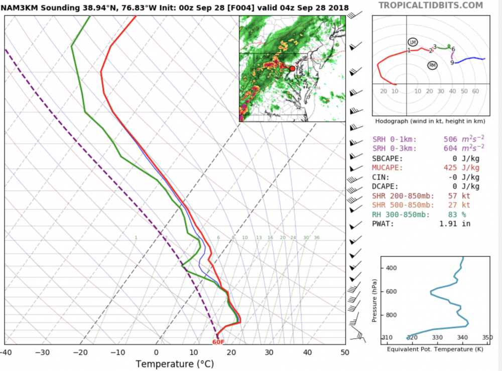
definitely. forecast soundings show some elevated instability, so while I'm not sure if we'll get lightning, a convective element to the rain is likely. The simulated radar seems to show that.
-
20 minutes ago, osfan24 said:
I was just about to come here to post that. It's been really consistent run after run on some type of line of storms in the 6-8 pm range.
and the NAM nest has been consistent for the past 8 cycles or so.....
-
25 minutes ago, MN Transplant said:
Effortless.
54.87" on the year.
Probably should have a flash flood watch up for this afternoon. Any downpour could do it.
Agreed, especially for areas along and north of I-66 in VA and Rt 50 in MD, where there pretty good agreement on storm coverage. Also think that there should be more emphasis today on the threat for trees coming down easily in storm wind gusts, given the saturated soil.
-
9 hours ago, yoda said:
I posted this in the September disco thread:
"00z 3km NAM has some interesting storms around the region from 21z WED to 00z THUR... maybe severe"
That sums it up. Looking more closely, the last 5 (at least) NAM nest cycles show this, along with the 12z HRRR and all last night's Hi-Res Windows. It's rather impressive agreement. I'm still concerned about trees toppling easily in the saturated ground.
-
 1
1
-
-
Multiple NAM nest cycles show storms initiating well ahead of the main squall line late Wednesday afternoon on some sort of lee trough. Instability is decent, and deep layer shear is probably sufficient for some svr gusts. Given how wet the soil is, I suspect that trees could come down even if gusts are only in the 35 kt range.
-
 1
1
-
-
2 minutes ago, NovaTarHeel said:
There was some damage about a mile from my house from one of the Midlothian tornados, but my neighborhood is safe.
Looks like more storms tomorrow as Florence exits. Would we get round 2 tomorrow or should those be more “normal” thunderstorms? Today was pretty damn scary.
The low-level shear that favored rotation today will NOT be present tomorrow.
-
 1
1
-
-
ah geez. UMD has a private company issue tornado warnings for their campus, independent of NWS warnings.
That must be what's happening again today. That couplet that's near Silver Spring now was never really on a path towards campus.
-
 2
2
-
 1
1
-
-
looks like a weak couplet near Takoma Park
-
Looking at the NAM nest and HRRR, while the greatest coverage of storms will be over the next few hours, a few more could be around later during the night. Decent shear profiles will remain in place, and instability won't drop off much in this air mass. Not sure we can rule out an isolated supercell overnight.
-
 1
1
-
-
22 minutes ago, osfan24 said:
Where is the excessive rainfall forecast coming from today? Radar looks empty, forecast is not for much today, and while those dumb futurecast things aren't all that accurate, all they show is very isolated storms later.
The 15z update removed our area from slight risk (still in marginal) and specifically noted the reduced threat for DC/MD/VA in the discussion.
-
 1
1
-
-
Just now, osfan24 said:
Ummmm radar not looking so hot for Ellicott City right now. Where is the flood warning there? I'm to the east of that activity and can hear pretty constant thunder. It's gotta be dumping there and it just keeps stalling and re-forming.
You beat me to posting this. Definitely looks like training setting up for Ellicott City right now.
-
 1
1
-
-
lightning show as this storm approached was fantastic. now getting a legit downpour
-
57 minutes ago, WxUSAF said:
Hugging the 384hr GFS. Looks like widespread 40s in the burbs.
ALL IN
I'd love to hug that too, even as a fantasy, but in the meantime, I'll hug something that's actually in the short range: GFS and Canadian both show some pretty major cold air damming Sunday, with a rainy here and daytime temps in the 60s.
-
 2
2
-
-
pretty impressive rainfall rates here in southern Howard County
-
1 hour ago, Eskimo Joe said:
Meso guidance looks pretty meh tomorrow.
The question seems to be whether any storms will fire during the day out ahead of the main forcing. Neither the cape nor shear are particularly crazy during the day, but the combination must just be sufficient for SVR if we get storms. Otherwise, the best chance of widespread storms is way late during the evening (as per the NAM3), but they might be slightly elevated with lesser threat of SVR.
I am also keeping an eye on Wednesday, when the secondary cold front arrives during peak heating, with better lapse rates and deep layer shear in place.
-
Just now, Eskimo Joe said:
Are there referring to this small inversion on their 12z balloon?
I thought about that, but that's clearly something that would mix out quickly during the heating of the morning hours.
-
 1
1
-
-
Can someone please tell me what LWX is doing the last two days? They keep talking about an inversion that will retard convection, but it simply doesn't exist in any of the forecast soundings, and the relative ease with which convection is developing again today (albeit scattered coverage) confirms it's not that tough to initiate convection in this environment. Forcing is weak, which is preventing widespread development, but the idea that we'd have a quiet day is again going to fail.
-
 4
4
-
-
2 hours ago, wxdude64 said:
Had two rounds of showers roll through in last two hours...what happened to the mostly sunny and 82 forecast from this morning?
Not a great showing by LWX today. They mentioned that there was a forecasted cap that would inhibit storm development, but I didn't see it on soundings I looked at this morning. The hi-res models all showed a few cells in the area this afternoon, and they nailed it.


2018 Mid-Atlantic General Severe Discussion
in Mid Atlantic
Posted
The sfc low is a going to take an extremely favorable track for the I-95 corridor. Wind profiles this evening will become as good as we can get around here, but the degree of instability is the big question.