

high risk
-
Posts
2,596 -
Joined
-
Last visited
Content Type
Profiles
Blogs
Forums
American Weather
Media Demo
Store
Gallery
Posts posted by high risk
-
-
1 minute ago, yoda said:
What do you think of the 00z NAM NEST tonight? STP looks to be pretty high across the region from 02z to 08z MON... looking at it on weather.cod.edu
I was looking at it when you posted. Sunday night could be very, very interesting around here. As I noted earlier, the NAM keeps temps well up in the 60s Sunday night, so the usual big drop in overnight instability here won't be an issue. While the overall wind profiles have some veer-back-veer in them (which can limit the ability of cells to stay discrete), and the cape is a bit "tall and skinny", the low-level shear looks truly outstanding, and the NAM NEST certainly suggests some cells out ahead of the main line. Tomorrow's day 2 for Sunday/Sunday night will almost certainly extend slight risk into our area, and it could end up as an enhanced risk.
-
 3
3
-
-
3 hours ago, Kmlwx said:
The 12z 12km NAM also looks kind of good for overnight Sunday into Monday...but we all know how nocturnal stuff usually works for us. Unless that speeds up to be Sunday afternoon it probably won't be much.
The overnight threat Sunday could materialize better than overnight threats usually do here if the NAM is correct. It shows strong southerly winds keeping temperatures here in the upper 60s through the night.
-
5 minutes ago, AmericanWxFreak said:
NAM3 looks pretty intriguing for those near DC again
It does, but look at the 2m dewpoint field. It has dew points rocketing up into the 62-64 range as the precip approaches which allows it to blow up the convection. Actual dew points have been falling this afternoon, more in line with what the HRRR is showing.
-
The key for today appears to be the low-level dew points. NAM3 moistens us all afternoon, we end up with low/mid 60s dew points by late afternoon and a pretty unstable atmosphere. HRRR mixes and advects some low dew point air into our region during the afternoon, and we end up in the low 50s by late afternoon.
-
8 minutes ago, North Balti Zen said:
This for Friday? I am driving to Lynchburg and back that day - maybe will be in the right spot coming through central VA in the afternoon to see some storms perhaps.
yeah, I could have clarified, although the NAM3 only goes to f60...... But while Friday does have some potential, I am talking about today.
-
I had been "way out" on this event, but the 12z NAM3 is making me reconsider, with some impressive signatures much further north than in previous runs along with greater instability and a shear profile that is lacking in low-level shear but would have decent deep-layer shear with a modest increase in sfc winds. This solution is an outlier for now, but I'll be curious to see whether the HRRR trends in its direction.
-
HRRR soundings showing about 500 sfc-based cape, and SPC has added our area into general thunder. Will certainly be interesting convection around this afternoon.
-
1 hour ago, George BM said:
Also look graupely with,dare I say, some graupely snow mix in with the most intense showers?...... Or is my weenie mode getting carried away again?
very low freezing levels. definitely possible.
-
Friday afternoon could be a bit fun as the strong vort approaches. Convective showers are likely, and with very steep lapse rates, it looks like a few folks could see some lightning.
-
first thunder of the year in North Laurel!!
-
1 hour ago, WxUSAF said:
When will the CAD break?
We saw this exact scenario 2 weeks ago, also on a Sunday. The wedge doesn't give up easily, and the temperatures are going to bust, except in the western areas. Models are still emphatic that we'll break out in a few hours and get to the upper 50s - maybe we can get that high, but I think that 60's in the metro areas are pretty unlikely.
-
Lots of talk about the light snow not being able to stick and references to the struggles of last Sunday, but this isn't a Sunday redux. 1) Air and ground temps going in to this storm are much colder 2) it's not necessarily a light snow event - if you look at the NAM3 in particular, it's mostly a 2hr burst of steadier snow that will rapidly cool the low levels
Don't get me wrong, it's still a weak, fast-moving system, and DC and points south will struggle to get accumulation no matter what, especially if the GFS is right getting us to the low 40s. But north of DC could get a quick 1-2" if the NAM3 idea of limited heating prior to onset and some short-lived heavier rates is correct.
-
7
-
-
10 minutes ago, AfewUniversesBelowNormal said:
NAM doesn't look bad
agreed. nice thump of afternoon snow for areas north of DC with temps in the mid 30s falling to lower 30s.
-
1
-
-
3 minutes ago, MD Snow said:
850's still draped through central Virginia into the south central delmarva. 925mb temps draped through calvart county into the central delmarva. Where they set up later this afternoon will have huge implications on where the cutoff for accumulating snow.
except the the guidance has repeatedly indicated that the primary warm layer will be around 800 mb
-
it's really worth noting that the NAM and NAM3 10:1 maps show accumulation overnight for much of the I-95 corridor, even though the p-type is mostly rain. That means that the microphysics inside the model are cranking out some sleet for sure, even though the p-type shows rain due to the p-type being computed outside out the model purely based on the thermodynamic profile. Don't take the accumulation numbers literally, as a 10:1 ratio obviously shouldn't apply to sleet, but the fact that it's non-zero is telling us that the model has at least some frozen falling in a profile that is so close to supporting more frozen, and it supports the idea that it wouldn't take much cooling to be a much bigger deal.
-
9
-
 2
2
-
-
1 minute ago, psuhoffman said:
So what does it make me when its a good event for the "northern tier" but the max is still south of me? lol
LOL. It was too much and too confusing for me to write "for the southern half of the northern tier."
-
 2
2
-
-
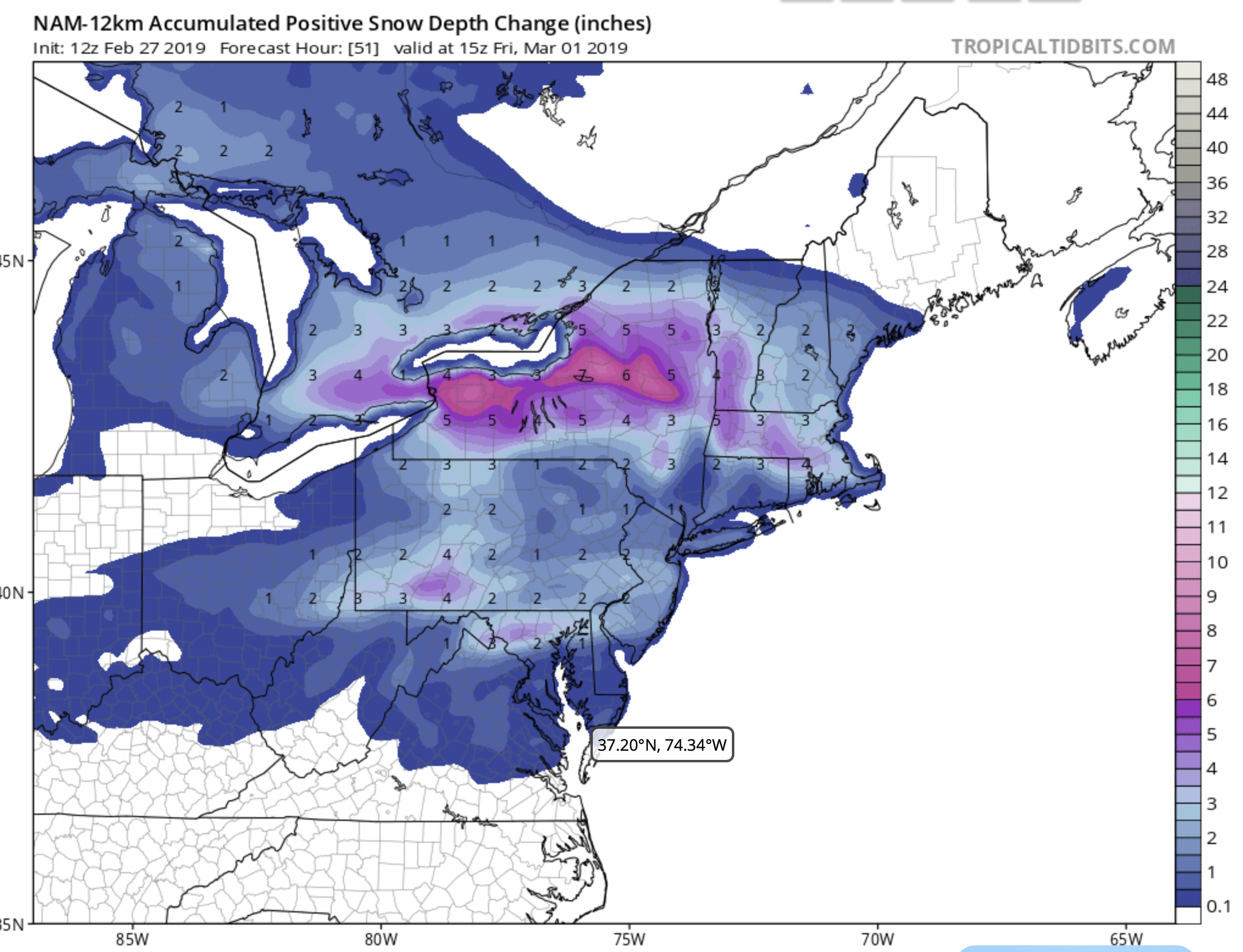
can we stop saying things like the NAM3 has 5" and crap that like? The TT 10:1 map has 5". The model does not. If you want to know what the actual model is doing, look at the snow depth change or Ferrier maps. They're much lower, indicating significant riming of the snow, consistent with the forecast soundings which show a possible warm layer around 800. It's marginal with that warm nose, so those depth and Ferrier maps may end up too light, but the model does not have 5".
-
8
-
-
nice event for the northern tier

-
2
-
-
NAM is a wet outlier, but the NAM3, CMC, and GFS are somewhat in line for 1-2" across parts of DC Metro.
-
2
-
-
NAM3 brings us back to reality a bit, but it does show the potential for a couple of heavier snow bands.
-
a reminder to, at the minimum, split the difference between the 10:1 and accumulated snow depth maps, but that is still a LOT of precip. (or at least a lot more than we were expecting to see....)
-
1
-
-
Remember that the NCEP models tally sleet along with the snow, so when you see those generous snow maps, they're because TT is applying a 10:1 ratio to the liquid equivalent. The positive snow depth change is also plotted there, and it accounts for poor ratios and overall difficulty in accumulating - it's way less snowy for this case (consistent with the sleet).
-
2 minutes ago, usedtobe said:
Here's a question for you. Why does the NAM have a separate max over our area. It's not related to a jet streak. The low is well to the south as is the precip associated with the low. The vort is a meager looking thing arguing for a flat look. An inquiring mind would like to know.
NAM has some very good 850 mb speed convergence with a modest southerly jet. The previous wetter runs of the GFS had the similar jet structure, but overnight runs have shown a weaker and more veered low level jet.
-
3 minutes ago, DCTeacherman said:
If they just got rid of the boom/bust stuff that’s a good map.
Disagree with all the people complaining about 1-8" ranges and boom/bust ideas needing to be tossed. Forecasting snow amounts isn't a contest. It's communicating the most likely outcomes along with the range of possibilities to account for model errors, localized bands, and such so that people who may need to travel or decide whether to close a business or school can assess the level of risk and their tolerance of it and make informed choices.
-
3
-
2
-
2019 Mid-Atlantic Severe Wx - General Discussion
in Mid Atlantic
Posted
I'll agree with the props to LWX for the synopsis. Looking at the early components of the 00z suite, the HRRR wants to initiate some convection during the late afternoon in the area that would have slightly better low-level instability to work with than later storms - this might be an earlier show, with lesser severe potential later at night. The NAM nest avoids the earlier convection and has the show all being later at night, with an ominous radar showing cells and line segments. That said, the cape is very tall and skinny, which reduces the severe potential at least a little, but the low-level shear is still very impressive.