

high risk
-
Posts
2,596 -
Joined
-
Last visited
Content Type
Profiles
Blogs
Forums
American Weather
Media Demo
Store
Gallery
Posts posted by high risk
-
-
Seems like a pretty good shot that northern VA, eastern WV, western MD, and south-central PA will get a MRGL risk for severe Friday, with an outside chance of an eventual SLGT.
-
24 minutes ago, wxmeddler said:
DCA TAMDAR aircraft at 2:58z had 50 kts at ~950mb (1900ft). Peak of LLJ at ~912mb (2800ft) with 63 kts. Nearly isothermal from SFC to that height.
The isothermal profile surprises me, as the models have shown a pretty significant low-level inversion. That could certainly up the threat of stronger overnight surface gusts.
11pm: 60 at DCA, 57 at BWI, and 55 at IAD.
-
56 minutes ago, yoda said:
Definitely think we have some thunder potential overnight, but I haven't seen any forecast sounding with surface-based instability. So, while there will be strong winds just above the surface, it seems like the chances of them mixing down are low. I'm still more intrigued by the late afternoon/early evening time period Friday when we'll have modest but surface-based instability.
-
 1
1
-
-
NAM nest shows a dramatic warm frontal passage, with low 40s for DC metro at 8pm and near 60 by midnight.
-
1
-
-
52 minutes ago, yoda said:
So you say there is a chance Ian...
There definitely does appear to be a window of opportunity west and northwest of DC Friday afternoon. Instability is limited, but there is some cape, and lapse rates will steepen as the colder temps aloft arrive. The shear is outstanding, and there will be forcing along the arriving front.
-
1
-
-
5 hours ago, C.A.P.E. said:
Yowza. Look at those PWATS. Dews approaching 60 too. Maybe some thunder. Good thing we desperately need the rain.
Thunder definitely seems to be on the table for most of the area Thursday night and for points east on Friday. Good elevated instability early Friday:
-
1
-
 1
1
-
-
4 minutes ago, Buddy1987 said:
My brain cells must be warped today bc I’ve been on there and I don’t see anything labeled the FV3. Only NAM, GFS, GEFS and the normal models.
The mageval.ncep.noaa.gov is the site for parallel versions of models. If you click on GFS, you get the parallel GFS, which is the FV3GFS. If you don't believe me, check out the 12z 'GFS' on mageval and compare it to the TT FV3GFS plots.
-
3
-
-
3 minutes ago, JakkelWx said:
you sure you're not looking at yesterday's 18z?
go ahead and check for yourself. It's clearly listed as the 18z run on 12/4. It clearly ran, and that's the NCEP site which can plot it directly from the files on the supercomputer. There is clearly some issue with the other sites that have to download the data.
-
1
-
 1
1
-
-
18z FV3GFS (per mageval.ncep.noaa.gov) took a bit of a step back. 0.5" liquid line stays well south in VA, with the DC area on the northern edge.
-
4 hours ago, EastCoast NPZ said:
Another rainy weekend. Yayyyyyy.
Ummm, Sunday looks dry and overall a pretty nice day.
-
00z GFS taking a big step towards the idea of at least a close call on Tuesday
-
6
-
-
1 minute ago, pasnownut said:
Why wouldn't they want to incorporate and updates into the current GEFS. Too much math? j/k
ha! There is no way (in terms of manpower and computer resources) to do the complete set of retrospective testing and evaluation that needs to be done (much of the past 3 years were rerun with the FV3GFS and assessed as part of the validation) for both the GFS and GEFS systems concurrently.
-
1
-
-
10 minutes ago, psuhoffman said:
Ugh....so we will still be using the same gefs even once the gfs op is gone? I'm really looking forward to that upgrade...more than the op.
correct. There will be no change to the GEFS when the FV3GFS replaces the GFS in operations.
-
1
-
-
30 minutes ago, WxUSAF said:
No idea although I would assume the ensembles will also transition to FV3.
Yes, but it will not be concurrent with the switch of the GFS to the FV3 core. The GEFS upgrade to FV3 is still over a year away.
-
6
-
-
This event is our reminder to always toss GFS thermal profiles in cold air damming situations.
-
6
-
-
It's worth noting that the HRRR has rain at the start and then transitioning quickly to sleet and then snow, with a heavier burst of snow around 10AM. NAM nest is similar, with an initial period of rain and sleet, followed by some heavier snow, also around 10AM.
-
1
-
-
18z 12km NAM still has the 2m freezing line running right through the District at noon Thursday.
-
2
-
-
2 minutes ago, osfan24 said:
LOL, I don't even see how that's possible based on just the precip panels. It only possibly snows/sleets in Baltimore, for example, for a max of six hours and probably much less than that, yet it shows 9 inches. But yes, 1/4 of that would be pretty historic and quite exciting.
The precip type is computed off of the thermodynamic profiles; the water equivalent of snow (+sleet) is from the model microphysics. That's how that can differ. And this is clearly a case when the 10:1 ratios won't come close to working.
-
2
-
1
-
-
I really have a hard time accepting the GFS having most of the DC and Baltimore metro areas in the mid 30s tomorrow at 12z. I think we've seen plenty of winter precipitation cases in which the GFS has failed to properly model evaporative cooling and then eroded low-level cold air too quickly. While the NAMs can hold on to low-level cold air a little too long, their track record in this kind of setup is superior. I'm not calling for an OMG snow here in the I-95 corridor, but a few hours of snow and then sleet (and perhaps a longer period for the next tier of counties north and west) is still very much on the table, IMO.
-
9
-
-
1 hour ago, showmethesnow said:
After looking over some things since the 12Z runs I have to wonder if the bigger story might be the ice/sleet storm that some people get. Have a feeling that we will see a band 25-50 miles wide of a fairly significant ice storm shaping up centered on or near the cities. Also leaning towards the favored areas to the west and around PA line actually have warning criteria snows.
Significant ice storm near the cities? That's going to be extremely difficult to accomplish given the very warm antecedent ground/road temperatures.
-
5 hours ago, yoda said:
No talk about the threat for tomorrow afternoon? AFD mentions threat for some severe with damaging winds main threat but also the potential for a few tornadoes
The problem is that the hi-res guidance is now in good agreement that the line clears most of the area by midday, and there is limited opportunity for the atmosphere to destabilize in advance, especially from DC and points north. Chances are better for southern MD and points further east and south, where guidance shows either more warm advection ahead of the line or a later arrival of storms allowing more heating to occur. That said, shear in the local area will be strong, so if instability ends up larger than currently progged, we could certainly have a greater threat, including TORs.
-
2
-
-
reports of significant damage in Mt Airy. New tornado warning in southern MD.
-
MD issued by SPC. Watch possible as the strengthening line to the west approaches.
-
39 minutes ago, Kmlwx said:
@high risk - how much CAPE do you think will be enough to do it?
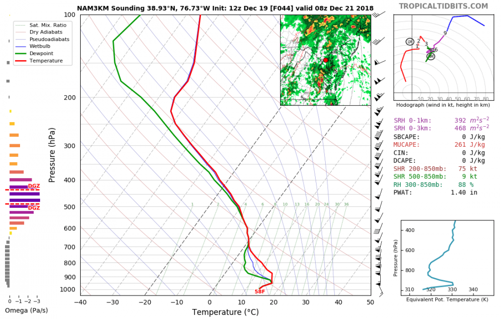
great question. The issue may not be the amount of total cape, but the distribution of it. I think in these low instability/high shear events, you can work with 500 or so, but there needs to be some instability just above the sfc. Tall, skinny cape usually doesn't get it done. That forecast sounding has lousy low-level lapse rates and likely would not get the job done, assuming it's correct. History says that these low instability/high shear events rarely work out here, but there are exceptions.

December Discobs Thread 2018
in Mid Atlantic
Posted
more for damaging wind, as wind profiles are strong but somewhat unidirectional. Still, there is perhaps enough low-level backing of winds closer to the sfc flow to make it so that an isolated tornado cannot be ruled out. Instability is limited (which prevents a more robust threat), but low-level lapse rates will be good. Forecasts like these intrigue me.....