

high risk
-
Posts
2,621 -
Joined
-
Last visited
Content Type
Profiles
Blogs
Forums
American Weather
Media Demo
Store
Gallery
Posts posted by high risk
-
-
On 2/16/2022 at 11:17 AM, Kmlwx said:
Aw shucks - I'm not THAT smart with this stuff. Most of my strength is anecdotal past stuff. I defer to the red taggers mostly, though. I'm closer to @yoda's copy and pasting than I am to the @high risk analysis.
As much as I like snow - and hate 85+ degree weather, I do prefer spring/summer on the forums to winter. Much more of a cordial environment. Seems us severe weenies are way more able to accept that we just don't go big on severe very often versus the winter weenies who are seemingly "entitled to" all winter storms
")
So nice to see this thread! Cheers to a great 2022 severe season! That said, I'm not very excited about later tonight. Temperatures should stay up overnight, but we need every degree we can get, and having the threat in the afternoon would have helped. The shear is awesome, but the lapse rates suck, and there just isn't much chance of getting even a few hundred joules of cape. There will be convective enhancement of the rain early Friday, but it seems like the SVR threat is really, really low.
-
 2
2
-
-
Some reasonable agreement between the 18Z NAM Nest and GFS - my confidence level always goes up with they align.
-
4
-
-
The precip shield is pretty clearly going to extend further to the northwest than initially thought. The problem for weenies, however, is that even with "close" sfc temps, the forecasted soundings overall don't seem to support snow on the northwest edge. That said, some of the temperature profiles wouldn't require too much cooling to become wet snow, so I suppose that a few surprises are possible.
-
4
-
-
11 minutes ago, MillvilleWx said:
Interesting upstream trend showing a lot of areas a touch colder than orginiallly forecast for the time being, but the warm nose is more pronounced to the south (Shocker, I know). I still like a climo based event for ice with the northern tier getting the brunt of the ZR risk. Mt PSU will be glazed over like a Krispy Kreme Friday but DC will only be able to see ice if they get a Dunkin Iced Mocha.
Areas with sneaky ice potential are spots like Damascus/Clarksburg/Mt Airy/Monkton/Jarretsville.
I can't argue with this thinking, and it seems like the 18Z NAM is moving towards that idea.
-
1
-
-
The 18Z HRRR laughs at our thread
-
3
-
 2
2
-
-
FWIW, and I say this with every caveat about no two events being the same, the ARW and ARW2 Hi-Res Windows were the coldest (and most erroneously cold) models for the January 20 rush hour bust. The GFS and Hi-Res Window FV3 were the next coldest. NAM and NAM Nest were next "best" but still a bit cold. The Canadian models did the best. Again, it was a single case, but it did involve shallow cold air spilling into the area.
-
6
-
 2
2
-
-
4 minutes ago, Bob Chill said:
Laurel ice weenies are no doubt rooting for another 3 hundredths
Oh, F*ck yes!
-
13
-
-
29 minutes ago, MN Transplant said:
I don’t actually know why they use that terminology. SREF is ensemble-based, so it uses slightly different initial conditions to see how robust the solutions are to model/observation error. It is an older system so they aren’t as advanced as other methods now.
Way more SREF information than anyone ever wanted or needed, but in addition to initial condition differences, the members are comprised of two different cores, and there are some other physics differences too. And one of those model cores is a system that has mostly been retired, so as noted, it's very much an outdated system.
-
2
-
2
-
-
I'm really surprised by what I've seen from the guidance so far today, as while the GFS is documented to do a poor job with shallow cold air masses, it's usually *slow* to bring them in. Seeing the GFS be faster than other guidance with the arrival of the cold into our area is not what I expected to see. The bottom line is that I need to see another model show the same idea before I'm going to get anything close to being on board.
-
18
-
-
1 minute ago, jayyy said:
I can only imagine. I think it may bust big time in Boston proper. Seen this saw and dance before. One model camp shows 6” and another showing 30”. Rarely ends with the latter for them. These setups can go very wrong, very quickly for BOS, while the hamptons over to cape cod still cash in. December 2000 comes to mind here. Miller B transfer situation. Widespread 10-20+ with 30” lollies all around NYC (NNJ, NYC, Western LI, extreme W CT) while Boston, RI and coastal SNE saw 4-6”
I lean towards lower totals in the jackpot zone too, but as some of the cooler heads (or major weenies) have noted in that discussion, there was a storm in 2015 (I think) where the models kept the huge snows out of southeast New England despite an amazing look at h5, and they ended up getting crushed.
-
12 minutes ago, jayyy said:
Lived up in this area (nyc surrounding area) long enough growing up to know that the current look at h5 and position of the surface low means a monster storm is coming for roughly Trenton and points ENE tomorrow. Absolute textbook setup. Excited to watch the bands come off the Atlantic tomorrow. Will try and capture some pics for y’all.
H5 looks super, but several models show a bit of a strung-out mess at the surface. The New England forum is freaking out.
-
9 minutes ago, high risk said:
NAM parent looks great with the snow, but temps are above freezing until early evening, so it might struggle to accumulate during the daylight hours.
edit: and "looks great" should have been "looks improved with the front end snow"
and of course, the Nest doesn't look as good.
-
 2
2
-
-
NAM parent looks great with the snow, but temps are above freezing until early evening, so it might struggle to accumulate during the daylight hours.
-
2
-
2
-
4
-
-
As we try to sort through all of the disagreement between the models, one thing that stands out to me is how much the GFS and NAM Nest agree on the precip field. I have no idea how this is going to play out, when the NAM and GFS disagree, but the NAM Nest is close to the GFS, I take notice.
-
2
-
-
2 minutes ago, high risk said:
18Z GFS looks much different than the 18Z NAM that had us throwing ourselves over the cliff last hour. Stronger, more phased wave and higher heights out front. Not saying that this will put the coastal low in a favorable spot for us, but it should hopefully retain our Friday evening/night snow here.
or not.....
-
9
-
1
-
-
18Z GFS looks much different than the 18Z NAM that had us throwing ourselves over the cliff last hour. Stronger, more phased wave and higher heights out front. Not saying that this will put the coastal low in a favorable spot for us, but it should hopefully retain our Friday evening/night snow here.
-
11
-
-
5 minutes ago, snowfan said:
Not sure the initial snowfall associated with the N piece is getting enough attention. Simply based on timing and the impacted area, prepare for a disastrous rush hour if this plays out. Dramatic, sure, but our area sucks with even a coating on the roads.
Perhaps, but guidance has us getting to the upper 30s during Friday and only falling back to around freezing for the evening rush. Moderate snow at rush hour will have some impact for sure, but that's not the standard recipe for rush hour disaster here.
-
1
-
1
-
1
-
-
8 minutes ago, yoda said:
18z GFS tries for 5" at DCA

Including DC metro into BALT metro as well
I'm thoroughly confused, as Pivotal 10:1 has almost 3" on the ground around DCA by 12Z, while TT 10:1 has a small fraction of that. The final totals then of course end up with a big discrepancy. There is a single snowfall field in the GFS (it's a liquid equivalent), so they should in theory be using the same field, applying the same 10:1 SLR, and getting the same result. One of them is doing something funky, and my money is on Pivotal being the goofball.
-
5
-
-
I'm always a big fan of the NAM Nest for this type of event, but it's worth noting that it's a bit later with the changeover than other CAMs, and it's also less aggressive with the temperature crash during and just after the event. Actually, the HiRes Window FV3 is also a bit slower with the change to snow and is a bit closer to the NAM Nest temperatures (although it still drops lower as the event gets cranking). I'm going to watch these details in later CAM runs today.
-
2
-
3
-
-
The Kuchera ratios seem a bit generous for an event with marginal temps through a decent depth above the surface. For now, I like a blend of the 10:1 maps with the positive snow depth change; a 1-3 along and northwest of I-95 and 2-4 well north and northwest might work well.
-
12
-
-
5 minutes ago, losetoa6 said:
1/2" qpf on several mesos
Some of that is rain at the start. The HRRR in particular has a couple of rounds of showers ahead of the snow.
-
2
-
-
1 minute ago, WxUSAF said:
DC has a watch and I don't??

I would bet my left nut that DC goes above freezing before we do.
-
1
-
9
-
-
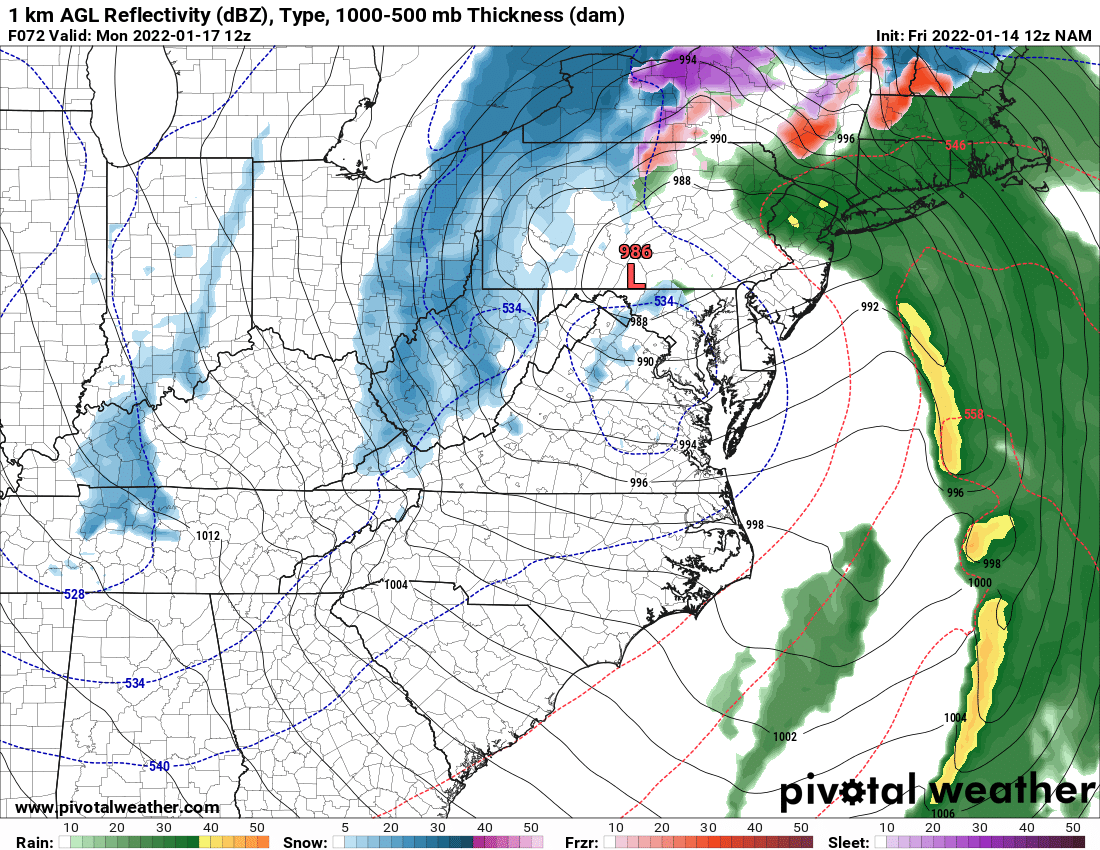
The NAM for Monday morning shows this:

and it's easy to look at that and say "some patchy light snow" in the DC metro area, but the 500 map shows an impressive vort pass right through the area at that time, so this is likely a representation of some heavy convective snow showers.
-
20
-
-
also worth noting that the GFS is considerably warmer at the start of Sunday than most other guidance.
-
1
-
February Discobs 2022
in Mid Atlantic
Posted
A number of the CAMs either explicitly show a similar feature or hint at it. The Saturday front is really strong, and the environment ahead of it will have healthy lapse rates, so I think that the chance of a forced line of convection along the boundary is fairly high. Temperatures would support rain showers quickly changing to snow.