high risk
-
Posts
3,146 -
Joined
-
Last visited
Content Type
Profiles
Blogs
Forums
American Weather
Media Demo
Store
Gallery
Everything posted by high risk
-

2022 Mid-Atlantic Severe Wx Thread (General Discussion Etc)
high risk replied to Kmlwx's topic in Mid Atlantic
Yes, that happens, but damming isn't a concern for Thursday - strong low-level southerly flow is pretty much a certainty. I've been less enthused about this event due to potential poor timing, but there is more hope in recent guidance. The HRRR and some of the HiResWs have convection breaking out during the late afternoon hours. The wind profiles will be strong, so any storms that try to take advantage of peak heating certainly have a shot to be severe. And low-level convergence looks better than it did several model cycles ago. The potential for 1) widespread showers and storms forming too early and wiping out heating and/or 2) the front hanging back and having the main line roll through the DC/Baltimore areas after dark are still on the table. We need every bit of heating we can get at this time of year to maximize potential. Storms rolling through after dark simply won't have the warm sfc temperatures and resulting larger CAPE values to work with. -
2022 Mid-Atlantic Severe Wx Thread (General Discussion Etc)
high risk replied to Kmlwx's topic in Mid Atlantic
Recent model trends have me liking this setup a lot less. There is lead wave that arrives midday Thursday - this has the potential to produce showers and clouds that limit afternoon heating. It also leads to a cold front that has more of a southwest-northeast orientation; we do better with a more south-north orientation. There isn't much convergence along the front as currently modeled (especially on the NAM and CMC - it's better on the GFS), and the main upper system lags pretty far behind. There is still plenty of time to get things much more favorable, but it definitely has limited potential as currently progged. -
2022 Mid-Atlantic Severe Wx Thread (General Discussion Etc)
high risk replied to Kmlwx's topic in Mid Atlantic
Definitely keeping an eye on Thursday, as there is good model consensus for a very strong system in the east. Given the cold air mass in place early Wednesday, it's obviously uncertain how far north the higher theta-e air will reach Thursday, but a slightly slower system (as suggested by the Euro) would increase our chances of seeing appreciable CAPE. -
Very clear convective threat with graupel and lightning Saturday. That is an intense upper system coming through at the right time of day - lapse rates are going to be terrific, and freezing levels will be low.
-
2022 Mid-Atlantic Severe Wx Thread (General Discussion Etc)
high risk replied to Kmlwx's topic in Mid Atlantic
I think you nailed it. Most guidance shows an enhanced area of convective cells moving through the area during the mid to late evening, but the surface layer is really stable. Lapse rates are garbage, so even elevated CAPE will be small (as you noted), and the sfc-based CAPE to our south will be limited too (hence only a MRGL to our south). I agree, though, that there may be just enough elevated CAPE to get some lightning, although I'm far from sold on the potential. The thunder potential might perhaps be a big greater much later tonight, as the low-levels warm a bit, and lapse rates slightly improve. Coverage of cells will be limited, but anything could put out some lightning. -
2022 Mid-Atlantic Severe Wx Thread (General Discussion Etc)
high risk replied to Kmlwx's topic in Mid Atlantic
I think that the timing is fine, but most of the CAMs have very few (at best) storms in our area. I'm not totally sure what the negating factor is, but I think that the orientation of the system will lead to strongly veered flow in the low levels, which as we know is subsidence in our area and mixed-out moisture. Barring some changes, it's going to again be a central PA event. -
2022 Mid-Atlantic Severe Wx Thread (General Discussion Etc)
high risk replied to Kmlwx's topic in Mid Atlantic
Trend in the NAM is really interesting. A slower arrival of the front allows for more heating Saturday and for moisture to return. 00Z run this evening has a good amount of CAPE, especially south of DC along with a not-too-shabby wind profile. -
3/12 Event: Winters Last Hurrah at Least East of Mountains
high risk replied to Weather Will's topic in Mid Atlantic
Completely understand the post, but the NAM doesn't give most of us 6". This is definitely a case to look at the snow depth maps, as the 10:1 is probably an overall too generous ratio, and the model is definitely showing some sleet which gets tallied in. There are flaws with the snow depth maps, but they (right or wrong) best represent what the model is actually predicting will be on the ground. That said, even the snow depth maps are 3-4" for many. -
3/12 Event: Winters Last Hurrah at Least East of Mountains
high risk replied to Weather Will's topic in Mid Atlantic
Thank God we're sneaking this event in just before the clock change...... -
3/12 Event: Winters Last Hurrah at Least East of Mountains
high risk replied to Weather Will's topic in Mid Atlantic
Definitely faster with the arrival of the cold air, which is key. Mid 20s for most by early afternoon Saturday. -
3/12 Event: Winters Last Hurrah at Least East of Mountains
high risk replied to Weather Will's topic in Mid Atlantic
Great question! The issue you mentioned might be leading to slightly higher sleet amounts than justified by the model output, but I checked the forecast soundings, and the GFS does show profiles that favor sleet for a few hours Saturday morning. -
2022 Mid-Atlantic Severe Wx Thread (General Discussion Etc)
high risk replied to Kmlwx's topic in Mid Atlantic
pretty remarkable that we're too far south to get in on the good SVR threat for an early March event -
2022 Mid-Atlantic Severe Wx Thread (General Discussion Etc)
high risk replied to Kmlwx's topic in Mid Atlantic
There are reasonable questions about how far south the threat will extend, but there is a steady stream of wind damage reports coming in from central PA. -
Wednesday March 9th wet snow(snow TV?) threat
high risk replied to George BM's topic in Mid Atlantic
Absolutely. High rates would allow those us north of town to get some whitening for sure. I'm cautiously getting on board with the idea of seeing some accumulations on certain surfaces, as even the models which are typically too warm in these scenarios are close to showing this scenario. If I lived north of I-70, I'd be feeling good about about increasing chances for a few inches.- 93 replies
-
- 10
-

-
2022 Mid-Atlantic Severe Wx Thread (General Discussion Etc)
high risk replied to Kmlwx's topic in Mid Atlantic
A number of the HRRR solutions today have shown these crappy pre-frontal showers and have been less enthusiastic for our SVR chances. -
2022 Mid-Atlantic Severe Wx Thread (General Discussion Etc)
high risk replied to Kmlwx's topic in Mid Atlantic
Too far out. Looks like a very strong system with an intense front, but verbatim, there isn't right now an impressive push of warmth and moisture in advance, and it comes through too quickly and too early. If that changes, and it becomes a slower system, we would have time to advect a more impressive air mass into our area ahead of the system, and it might come through at a better time of day. Both of these would open the door to SVR chances. -
2022 Mid-Atlantic Severe Wx Thread (General Discussion Etc)
high risk replied to Kmlwx's topic in Mid Atlantic
It's hard to get excited about an event with such a small chance for lightning, but I suppose that the showers later could mix down some intense gusts. Given that we're already gusting to 35-40 knots, some convective enhancement could certainly take us into the severe range. -
Feb 24-25, 2022 Ice/Sleet/Rain/Snow (yeah sure) Storm Thread
high risk replied to WinterWxLuvr's topic in Mid Atlantic
I'm calling complete and total b.s. here. There isn't a model that gets 40 degrees to DC or even close by midnight tomorrow night, much less mid to upper 40s. This isn't some 995 sfc low blasting by to our northwest; it's a weak surface system with an accompanying weak pressure gradient, and the cold wedge will take time to erode. -
Feb 24-25, 2022 Ice/Sleet/Rain/Snow (yeah sure) Storm Thread
high risk replied to WinterWxLuvr's topic in Mid Atlantic
Surface temps around the metro area tomorrow evening, and the precip totals won't be huge, but there is a pretty clear signal for a period of sleet or freezing rain for a lot of us. Even if sfc temps warm up above freezing, there is a still a cold layer immediately above in pretty much all guidance for at least a few hours. -
Feb 24-25, 2022 Ice/Sleet/Rain/Snow (yeah sure) Storm Thread
high risk replied to WinterWxLuvr's topic in Mid Atlantic
I don't know for sure, but I think that they're at least using the precip type information directly from the models and not computing it themselves. Regardless, it's applying an instantaneous precip type to an accumulated precip. -
Feb 24-25, 2022 Ice/Sleet/Rain/Snow (yeah sure) Storm Thread
high risk replied to WinterWxLuvr's topic in Mid Atlantic
Right! It's most pronounced for the NAM beyond 48 hours or the GFS beyond day 5, as those models have hourly output through those times, although that assumes that the various sites are actually pulling in the hourly data. The bottom line, though, is that it definitely inflates freezing rain and sleet totals. -
Feb 24-25, 2022 Ice/Sleet/Rain/Snow (yeah sure) Storm Thread
high risk replied to WinterWxLuvr's topic in Mid Atlantic
This is a fair point. None of these accumulation computations is making any attempt to determine how efficiently the ice can accrete. They're just looking for freezing rain as the precip type at the top of the hour, and if that is found, all of the QPF from the past hour (or in some cases, 3 or 6 hours!) goes into the freezing rain bucket. In fact, only the RAP/HRRR actually have a true tallies of freezing rain and sleet. -
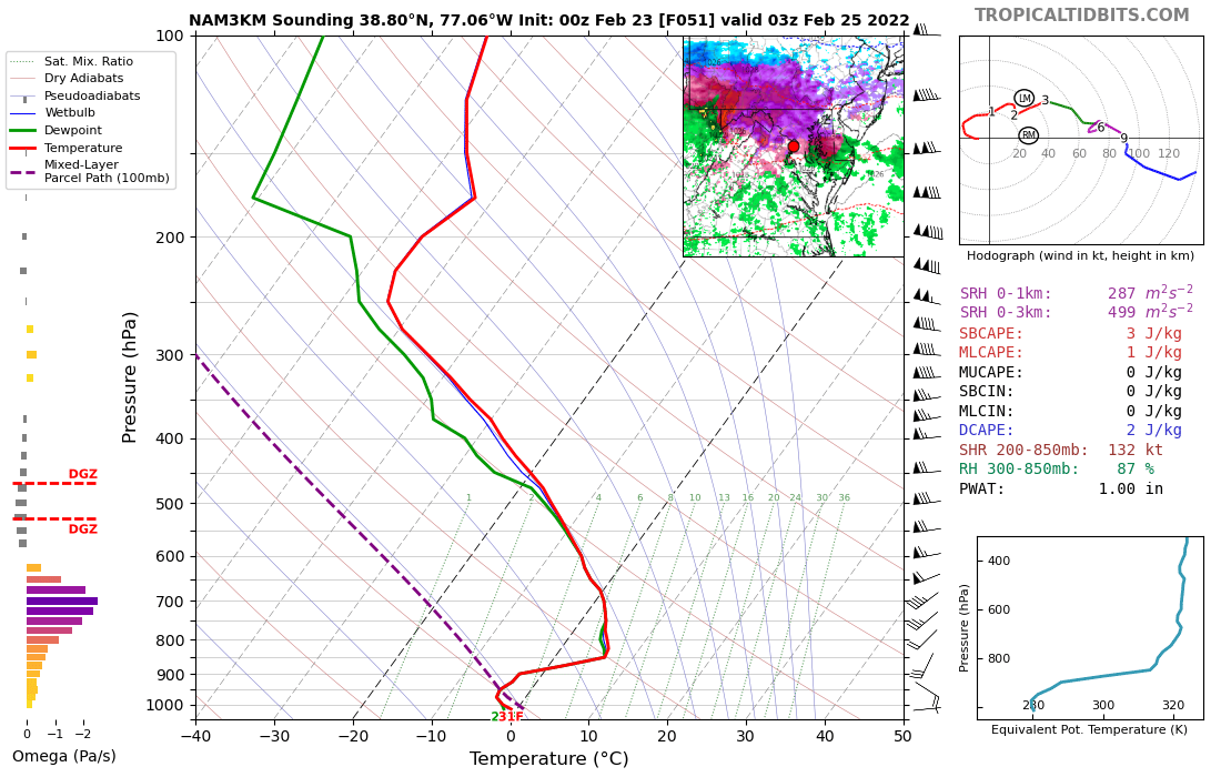
Feb 24-25, 2022 Ice/Sleet/Rain/Snow (yeah sure) Storm Thread
high risk replied to WinterWxLuvr's topic in Mid Atlantic
I think I'm buying on sleet and freezing rain for at least a while in much of the area. Even if the sfc temps are too cold in the NAMs (and I'm not convinced that they are), it's pretty clear that there will be a fairly deep layer below freezing just above. Shows up really well on the NAM Nest: Even the GFS has the same idea - the cold layer isn't as cold or as deep, but it's there. The winds in that cold layer are southeast, so it won't be able to hold in for the whole night (until you get further north), but I think that the idea of a cold layer near the ground during the late afternoon and evening could very well be correct. The biggest wild card is actual precip, as there is still limited agreement on the QPF details.
-
A number of the CAMs either explicitly show a similar feature or hint at it. The Saturday front is really strong, and the environment ahead of it will have healthy lapse rates, so I think that the chance of a forced line of convection along the boundary is fairly high. Temperatures would support rain showers quickly changing to snow.
-
2022 Mid-Atlantic Severe Wx Thread (General Discussion Etc)
high risk replied to Kmlwx's topic in Mid Atlantic
So nice to see this thread! Cheers to a great 2022 severe season! That said, I'm not very excited about later tonight. Temperatures should stay up overnight, but we need every degree we can get, and having the threat in the afternoon would have helped. The shear is awesome, but the lapse rates suck, and there just isn't much chance of getting even a few hundred joules of cape. There will be convective enhancement of the rain early Friday, but it seems like the SVR threat is really, really low.