

jbenedet
-
Posts
7,149 -
Joined
-
Last visited
Content Type
Profiles
Blogs
Forums
American Weather
Media Demo
Store
Gallery
Posts posted by jbenedet
-
-
The exceptional drought out west is most impressive for the fact that it’s worsening while an UL trough is anchored over that part of the CONUS. They’re in terrible shape now given seasonality...
-
 1
1
-
 1
1
-
-
44 minutes ago, CoastalWx said:
You should see what a few hundred feet does here. There is a huge difference at 32.0F and like 33.5F. Which can happen in borderline events with a difference of 200-300'. Meanwhile, I may eventually move further south in Plymouth County. May shave off a few inches a year, but at least Phil comes to visit now and then.
Few hundred feet is like 40 miles of latitude.
When you go from Portsmouth NH, to the top of MT Washington, it’s like traveling 1500 miles in terms of climate zones and you can do it all in ~3 hrs.
-
Ouch. Not familiar at all with records out there, but if this verified must be close to one...
PA/NY


-
Beautiful day in PWM—north; meh day in HFD, crap day in NYC.
North and east for the win today.Overcast about an hour from NYC.
-
I’d take this climate of the Faroe Islands, but only if it came with the landscape.
-
1
-
-
We really aren’t that alone. I mean the northern mid Atlantic knows our pain, bc they’re getting most of it too. That looks like snow in central PA tomorrow, during the day .
Storm tomorrow going to move in pretty quick. I’d err on the side of “worse than forecast” . Southern/western sections going to be under overcast probably by 11 a.m.
-
Nova Scotia has been taking the brunt of every nor-Easter since February it seems.
Eastern sections of the subforum missed a BIG second half of winter by ~150 miles.
-
1
-
-
24 minutes ago, dendrite said:
Except last May 9 when it was still in the 30s in the late afternoon with sun and wind.
")
That’s a good one.
Light Rain in the morning at the coast, storm grazes us. Strong surface cold front through in the afternoon. Temp peaks in low 40’s at PSM. Completely different than today with HP overhead. But anyway yea taking what I said verbatim above—you’re right. Touché.
To put it differently: shift this coastal low headed for NS 200 miles west and May 8 2021 would be putting May 9th 2020 firmly into the past.
-
^Beautiful pics but eff snow on May 7, unless it’s at the tops of the whites...
-
 1
1
-
-
About as cool as you can get May 7 with full sun. Thermo read 60 but persistent light wind and very low dews made it feel like mid 50’s at best, even in the sun.
-
3
-
1
-
-
We locked into the best winter storm pattern of our cold season starting in mid April. Again.
Tough for snow lovers and warm weather lovers. Mother Nature around here figured out how to disappoint the vast majority.
-
1
-
-
May? We’re stuck in early April.
May 1st comes in like April 1st.
At least the sun will let us put March behind us now...
That said, I’ll happily take dewless 60’s most days of the year...Great day for a hike, outside of the far interior.
-
1
-
-
10 minutes ago, NorEastermass128 said:
No leaves on the oaks here. Buds appearing. Buds and small leaves on the maples and smaller trees.
Same here obviously.
And this is why day time temps alone don’t tell the tale. Many cold nights, low dews. CP air masses ruled the month—no subtropical air in our region. The entire month has had climo more like April 1–and the vegetation is saying the same. -
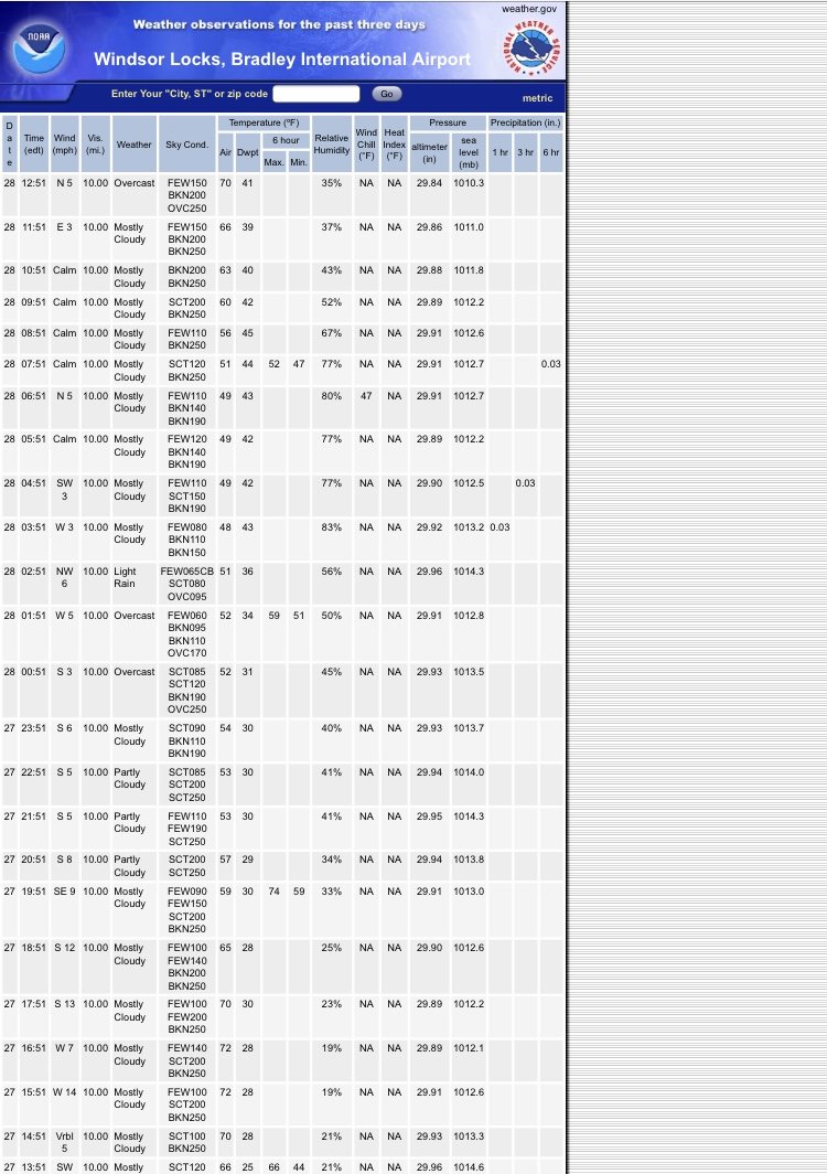
Cooking in Tolland 70/41 OVC, north wind on 4/28 at 1pm.
Break out the speedos
-
 1
1
-
-
4 minutes ago, Damage In Tolland said:
Just checking in while I’m eating lunch in the hot sun on the deck , tanning a bit. Still 3 hours of heating . How’s your day going?

Nice warm sector.
Tanning in overcast with dew in the 40’s.
Weenie rage.
How is my weather ? Very similar to what’s in your back yard as it should be. 60’s and mostly cloudy—the sensible weather is quite similar for the two of us, being we’re both outside of the warm sector.
-
1
-
-
Where’s @weatherwiz
This looks like a good one for him— for a short trip, that is...
-
Surprised SPC unenthused with severe risk in Eastern PA, Southwest CT, down to NYC, NJ.
-
1 minute ago, Damage In Tolland said:
It’ll be interesting to see if he acknowledges his errors or disappears like the snowstorm forecast
Coming from zero-accountability, zero-credibility guy.
At least we can zero in on on a few terrible forecasts from me.
And you? Where do we start.?
-
1
-
1
-
-
16 minutes ago, Damage In Tolland said:
No rain . No surprise . Convective not synoptic
This has been a truly warm spring. Best since 2012.
Can anyone let us know if Pope drops in here today. I’ll let him know the temps in the warm sector in CT
Kevin in Troll-land:
Sunday: “Days and days of high dews and heat incoming folks.”
Monday: “85F on Wednesday”Tuesday: “80F on Wednesday”
Wednesday: “Warm sector today”

Getting there buddy...
...And the rest of the week Kevin?

-
1
-
-
Tolland CT to be one of the worst places to be tomorrow—area-wide—sensible weather wise.
-
1
-
-
Tomorrow looks like a classic case—Danbury CT down to NYC tickle 80. New Haven sniffs the warm front for a few hrs maybe before the backdoor slams through again. And the rest of CT is on the wrong side of the door all day. It’s near 80 or near 60. Either way, Kevin will be yelling “dews” and stein” while he and Hartford are stuck on the wrong side all day.
-
1
-
-
47 minutes ago, rimetree said:
A balmy 57 with sun visible through the clouds. Models seem to be agreeing on a wet period later this week but will see if it holds. In the "abnormally dry" zone here but maybe that will disappear by next week.
It’s raining in Dover now. So surely you’re raining as well. Radar looks good for a 3 hr drink—backbuilding to our west
-
55 minutes ago, dendrite said:
In his defense this was looking a lot wetter a few days ago. Stein did its best to push this south. It mainly became a CT-SE MA deal.
Sure. But don’t get it twisted. Population distribution matters more than geographical area. That’s here; that’s everywhere. Many more people live in the region getting rain today. Boston is getting a good drink too.
-
1
-
-
1 hour ago, Damage In Tolland said:
Op GFS run? Ok !!
That isn’t details guy. The pattern strongly favors wet. Period.
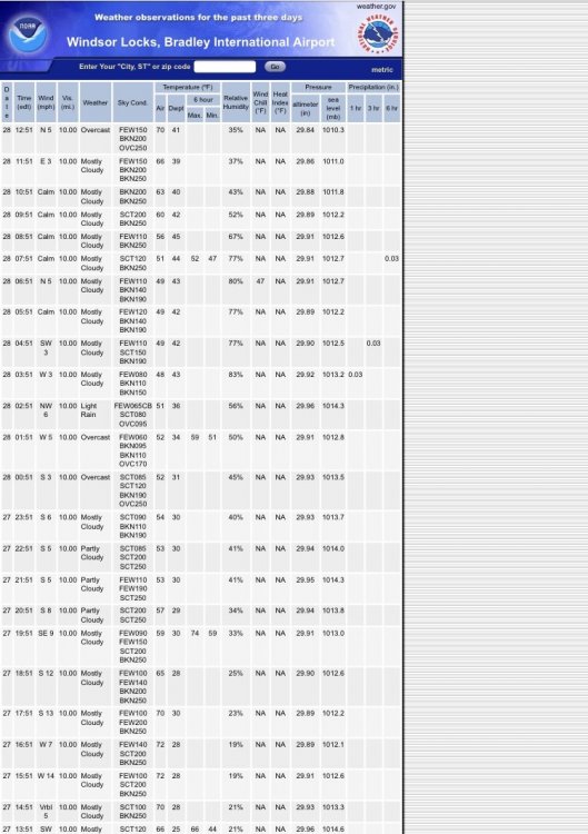
May 2021 Discussion
in New England
Posted
Memorial Day Weekend looking a lot more like Easter weekend on guidance. Euro conceding to the much colder and wetter gfs.
Big changes needed to turn that around.