

jbenedet
-
Posts
7,149 -
Joined
-
Last visited
Content Type
Profiles
Blogs
Forums
American Weather
Media Demo
Store
Gallery
Posts posted by jbenedet
-
-
48 minutes ago, HoarfrostHubb said:
We have a cherry tomato plant that is producing tons of fruit. In the last week or so it has been making some odd looking ones. We are at over 50 tomatoes from that one hanging plant
That’s awesome. My tomato plants are finally fully recovered from the drought and severe heat in June. I did what I could to get out ahead of it, but it was too extreme as to not impose a shock. It was a several-week set back but plenty ripening outside right now...
Not to digress..but most amateur gardeners think their plants aren’t producing much bc the soil is lacking nutrients—but if the plant itself is otherwise healthy and green, it’s most likely bc it is lacking water. Fruit and vegetables are ~90% water. The plant will conserve water, if water isn’t in surplus, and that means poor yield.
-
 1
1
-
-
The GEFS and EPS take this over Boston. If it’s a non-event, it won’t be bc of the track.
-
Not your classic TC, long wave trough interaction. It’s really more of a TC and potent shortwave interaction. I dunno what climo is off the top of my head but from what I recall, late spring or especially fall is when we have these come up our way due to more meridional flow that accompanies these seasons. We’re getting into mid July. We don’t have a big Bermuda High..What gives? I’m seeing surface temps in NNE in the 60’s while Areas of extreme northwestern Canada are pushing 90. A lot more baroclincity around the CONUS than one would expect. And that means more UL jet dynamics than one would expect. That’s my best guess as to what intensification the models curiously are seeing.
-
1
-
-
Looks to be hugging the western side of the cone since the 5a.m. update, but that’s just by eye. The track is still North or ever so slightly west of north. Not seeing an East component yet.
-
Highly Asymmetrical appearance; highly asymmetrical impacts. You could be 25 miles west of the center and be experiencing much better weather than those who are 150 miles to the east.
For all the disorganization Elsa is maximizing impact by maintaining the center off shore allowing tropical storm impacts to affect the entire west coast of Fla. The eastern side is also aligned with the background flow, adding to the surface wind-speeds.
-
 1
1
-
-
Today will be better than expected outside of East Maine. We are all drying out. It’s got a 70+ feel even up here
-
7 minutes ago, Modfan2 said:
I think New England needs to watch this for the rainfall potential adding to already soggy ground
I’d say eastern SNE is very much in the game. I’m not seeing a deep enough trough to make it interesting for points further north and west.
-
The impediments regarding fast forward speed and significant land interaction —hispaniola, and Cuba have been greatly reduced. And now Elsa is over the warmest SST’s in the Caribbean.
This is still a very interesting forecast. Relative to most recent guidance, surprises to the upside in terms of intensity are far more likely than the opposite...

-
47 minutes ago, weatherwiz said:
Temperature forecast tomorrow is quite interesting say across western Connecticut. Models show nicely warming 850/925 temps during the mid-to-late afternoon with some drying of the column. NBM for DXR also wants to get high's close to 75. I think that is a bit too aggressive but I wonder if there is room to sneak enough sun mid-to-late afternoon to push temps from say 68-70 to 72-74 later in the day
Usually this is capped by conditional instability—when there’s a deep UL trough overhead. You reach the upper limit and pay for it in terms of clouds and showers later. It’s nature’s quid pro quo.
-
Weaker storm, not vertically stacked means a much further west track, as the low level easterly flow predominates. My initial thoughts on an earlier recurve were wrong despite the intense trough over the eastern CONUS for this reason. The GEFS is illustrating this quite well now.
I think risk is now tilted in favor that Elsa ends up west of the current NHC cone. And that would translate to much less land interaction with Cuba and a lot more time over open water in the GOM. And we all know what that means in terms of vigilance.
A weaker storm over the next few days could mean a much stronger storm in the end.
-
1
-
-
This really is a warmer version of Memorial Day wknd. I’d be seriously enjoying these rainy cool breaks if not for the terrible timing...
-
2
-
-
2 hours ago, GreekWeatherGod95 said:
Coast Rider maybe? Or will it curve OTS
My guess is the first trough misses but influences a more northerly track. At that point it depends if a ridge builds over the top of it, or another deep trough comes in first and sends it OTS.
Landfall discussions are pointless at this juncture. I’m just saying the initial recurve happens earlier and makes it an east coast threat instead of a west coast FLA., GOM, threat.
-
2
-
-
My guess is this ends up much further east. SE coast threat. Big trough over the east—much earlier recurve. Trough will miss but influence a more northward track than current guidance.
-
1
-
1
-
-
6 hours ago, Ginx snewx said:
Well I meant for this run of course. Persistent pattern of HHH followed by cool rainy weather, here, that is
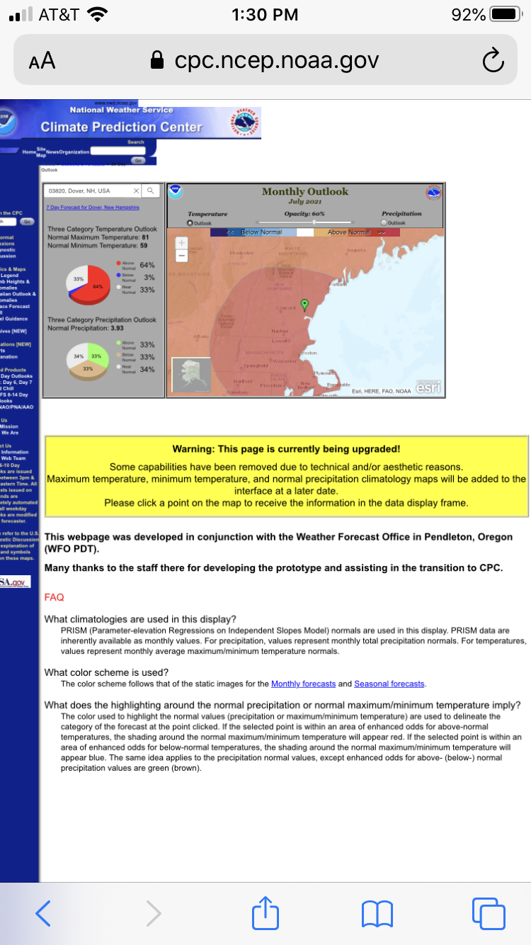
Yea I see that. That is my base case but CPC certainly seeing something quite different.
Hedge accordingly.


-
1
-
-
I’m just hoping for clouds at this point...
-
45 minutes ago, Ginx snewx said:
Bugs sweat stink stunk stank. Thank God its almost over. Lol. Imagine dealing with this for 90 days a year.
I can’t stand this weather. It’s not even July yet and I if I had to guess I’d say I have seen 10+ days of 90+ highs and 70+ lows already this year. We are going to get a wonderful break but it’s certainly far from over. The low temps have consistently been running well above normal. A 70+ low in summer is feeling quite normal, expectations wise, unfortunately.
-
4
-
-
5 minutes ago, psv88 said:
Nah, totally normal.
Yea. For Death Valley.
-
0z Euro is alone vs GFS Ukie and Canadian. And yesterday’s 12z euro looked a lot like what the rest of global guidance is showing...
It’s a high confidence bet still but the models couldn’t make it too easy for us...
-
Just finished walking the dog. Very steamy still.
My guess is temps don’t fall much at all from here, given some clouds, light wind...and dews rising slightly into tomorrow morning. 78 for a low tomorrow morning a.m. in Dover, if I had to throw something out there..,
What are the record high low temps...?
-
24 minutes ago, STILL N OF PIKE said:
Between the life threatening heat and popes tropical disturbance that may produce a 40 mph gust given conditions primed for “RI” ..I’m gonna be glued to the latest
I do kid with Tip, I just don’t see HI’s above 103 or so ..so it’s kinda just another Summer with a hot day
Man up. Winter season is sooo much more exhausting than this.Heat kills many more Americans per yr than TC’s. Probably should focus on the heat if you’re feeling overloaded by “hype “...
-
 1
1
-
-
“WAR strength”. Heh. That’s an unequivocal —NAO next weekend.
-
1
-
1
-
 1
1
-
-
1 minute ago, STILL N OF PIKE said:
The limiting factor with this system is time left over water . Not much time
Sure,
What are the limiting factors while it is over water?
There.
-
8 minutes ago, Typhoon Tip said:
I just see it moving into a no shear environment, with momentum in cyclostrophic flow already going ... over ample OHC. Not sure how many environment variable one really needs, but rip and read on those parametrics, I would not be shocked if TS watches go out for the SE Coast pretty soon here. LOL -
Dry air entrainment only limiting factor, and that will be a function of how organized the circulation becomes. If it tightens up here, it could well create a moisture pocket, and continue to quickly organize. As you noted shear itself is low—modest structural organization will go a long way in this case.
-
1
-
-
7 minutes ago, Typhoon Tip said:
Ho man ... 'magine if that thing did a 24 hour RI out of nowhere ...
The ones with no recurve/trough interaction up through landfall —like this one—are the most dangerous in this respect. Imo.
...
July 2021 Discussion
in New England
Posted
Perfect weather for the gardens. Yesterday I yanked my withering snap peas and planted carrots and lettuce for a second season harvest.