

jbenedet
-
Posts
7,152 -
Joined
-
Last visited
Content Type
Profiles
Blogs
Forums
American Weather
Media Demo
Store
Gallery
Posts posted by jbenedet
-
-
5 minutes ago, 40/70 Benchmark said:
I wonder if they will disappear for months following a bad forecast?
Or reappear on a high horse with no claim to fame but a free website?
-
 1
1
-
 1
1
-
-
Looking more and more “crappy” but surface pressure falling... all day...

-
It’s probably better to look at this more like a sub tropical cyclone at this stage.
-
 1
1
-
-
Just now, CoastalWx said:
Sandy was about 50mb deeper lol
Obviously. Man.
And still looked like shit on IR. We’re not in the tropics bro.
-
2
-
 1
1
-
-
Every TC that comes up this way looks like shit on IR. Even Sandy looked like shit. No rain on the entire eastern half.
-
2
-
2
-
-
4 minutes ago, Quincy said:
Pretty meh wind field outside of the immediate coast and area near landfall.

I’m not opining based on impact to SE New Hampshire.
I’m fascinated and tracking out of interest for south coast, Long Island and SNE (for flooding risks).
wind absolutely not the big story outside of coastal LI and CT. Otherwise it’s storm surge layered on very high seas—coastal flooding. Heavy rainfall.
-
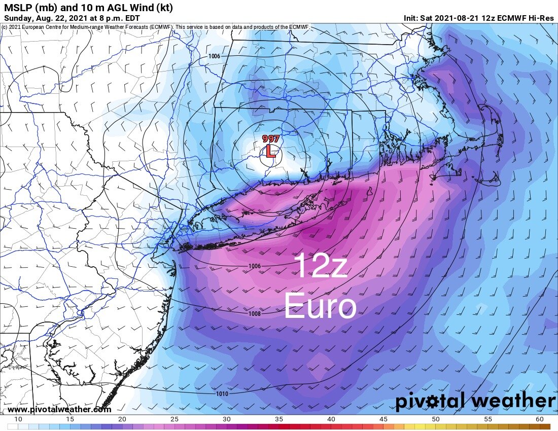
Euro initialized at 12z at 1001 mb. Henri was 993 mb per recon at that same time frame. Euro still takes it to landfall —high 980’s ish...
-
Significant expansion of the wind field right upon closest approach, as phase completed. AWT. New England being New England.
Model huggers flummoxed.-
3
-
1
-
-
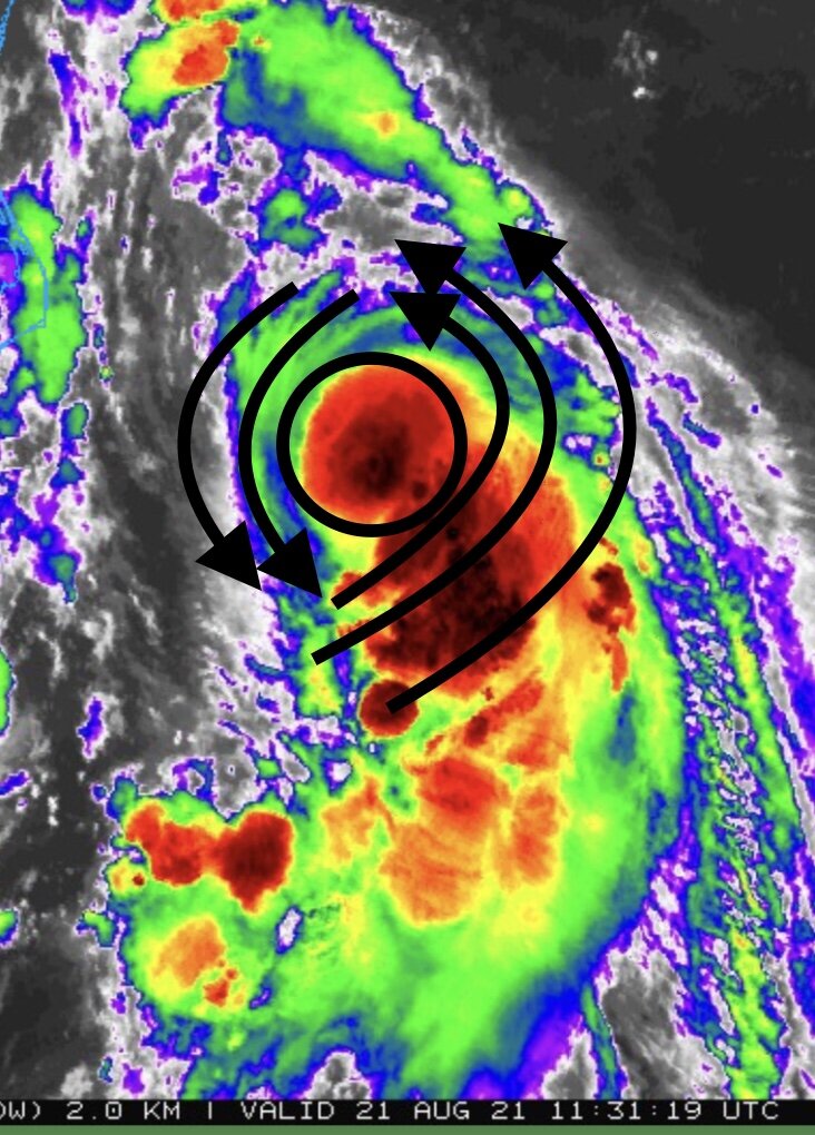
The symmetrical look of yesterday was a facade of organizing—competing CoC’s under a “CDO”
Today everything is coalescing around one CoC. This will look much more impressive on satellite in 3 -6 hrs.
-
3
-
-
“Looking under the hood”

-
I’m seeing some early signs that Henri is finally organizing around ONE center of circulation. He’s got a lot of work to do, but this very disheveled appearance looks like a “shedding” of the competing MLC, LLC state and evolution into a structure that is vertically stacked. Time is the limiting factor now.
-
3
-
-
Just now, SnowGoose69 said:
I still find it hard to believe in 2021 models could be that far off with the track this close in. Their cone seems somewhat absurd to me at 2pm tomorrow of NYC or Cape Cod. It’s probably 98% it ends up within 10-20 miles of their current position forecast at that time
To be fair, this recurve scenario close to landfall means uncertainty is quite high, at very short lead times. This is just a general rule of thumb. Accuracy goes up once new forward velocity attained.
What it implies here is a capture (phase). When does that happen and to what degree? It’s a very complex interaction, unfortunately.
-
I like the NHC’s track. Risk vs guidance is still skewed west—the recent trends East have been due to much less (minimal) phasing with the UL trough, and not less ridging to the east.
The former is a much more uncertain —error prone—aspect of the forecast.-
3
-
-
2 minutes ago, Ginx snewx said:
Ever been to Fishers Island? One of the grandest views of BI sound LI sound. Perhaps the best place to watch a cane with high bluffs. Golf course is silly sweet. Rocks on beach not so good.
I haven’t. But I’m intrigued. Are there local ferries out of Mystic?
-
Just now, WinterWolf said:
Pope ready to excommunicate Hoth lmao.
I’m really just sayin’ same guy has made same comment about rocks on his beach 4 times in past 48 hrs.
-
 6
6
-
-
4 minutes ago, Hoth said:
Maybe it'll at push some sand onto my beach. I've got a great sandbar just off shore, but nothing but rocks to sit on.
No one cares about your goddamn rocks, guy.
-
3
-
-
This is going to be an extremely difficult forecast at very short lead times. Model guidance showing that second recurve west beginning right as Henri is closest to land...
-
4
-
-
GFS Going to hook west into central LI me thinks
-
1
-
-
10 minutes ago, Typhoon Tip said:
I was just looking at the tide charts for NYC ... Looks like the 8:55 am Sunday tide ..should the west correction become more real, is unfortunately timed rather well with the approach to the coast that morning.
If this thing is a category 2 and it is moving headlong, bee-lined into the Bite region on top of that high tide cycle... oy
As a benefit will see how much was (not) learned post Sandy.
A microcosm of our macroeconomic system -
1 minute ago, weatherwiz said:
This x 1,000.
We can't get caught up over potential for hurricane force winds. A prolonged duration of gusts even 40-50 mph is going to do a quite a bit of damage. If we get into the 50-60 mph range...it will be on the ugly side. And well...that is becoming increasingly possible.
Winds are never the focal point for these in general, especially up here. Storm surge, coastal flooding and heavy rainfall.
-
5
-
-
GFS also now showing an expansion of wind field upon closest approach—alluding to UL assist/phasing.
-
4
-
-
1 minute ago, HoarfrostHubb said:
Rain. Lots of it.
Seriously concerned about the freshwater flooding in E CT and RI and SE Mass.that is the biggest risk up there imo
-
1
-
-
3 minutes ago, CoastalWx said:
I don't really see a big Et transition on any guidance though. It just sort of gets tugged NW and then rapidly weakens. Wind fields still tight.
Put on your New England climo hat.
i think some form of hybridization occurs but “how much”? Mostly tropical, slightly ET? 50/50? My guess is more the former.
-
1
-
-
Also we judge hurricane category by wind speed—which doesn’t directly translate to surface pressure falls (min pressure) IF the radius is expanding.
The forecast model for intensity based on wind speed doesn’t tell us nearly enough for a TC at 40N
-
1
-
Major Hurricane Ida
in Tropical Headquarters
Posted
Kinda surprised no one has mentioned this. There’s a 1018 mb high over Georgia. Quite robust for this time of the year. The synoptic scale players favor a significant gradient wind. The west side is not seeing the synoptic ageostrophic flow associated with the synoptic scale gradient as Ida’s center is between their location and the surface high. The flip side is this is making for significantly more wind on the eastern side AND with a substantial fetch over water, all along the east coast of LA. Coastal flooding well away from the center? You betcha. Look at how much more tightly packed the isobars are on the eastern side vs western side, well away from the center.